Mitchell - Angling Waters
View Mitchell River Basin in a larger map (opens new window).
The above map is provided by Google. The department accepts no responsibility for its accuracy or content.
Clifton Creek, Bairnsdale
Access to much of this waterway is through private property. Permission required.
A small tributary of the Mitchell River with brackish water in the lower reaches. The freshwater section contains southern pygmy perch, flathead gudgeon, European carp, goldfish, long-finned eel and short-finned eel. The estuarine water contains good numbers of Australian bass, estuary perch, sea mullet, black bream, luderick, and occasionally silver trevally and tailor. Species and numbers of fish vary with water conditions. Australian bass are most often found in areas of slow-flowing, deep water, near logs or other instream objects.
Crooked River, Grant
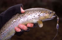
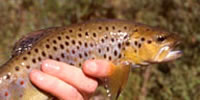
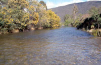
A wide river (15 m) flowing in forested mountains, boulder, rubble and rock bottom. During summer much of the rubble riverbed is exposed allowing good walking access along the channel. Predominantly shallow runs. Accessible from the Dargo High Plains Road via the Grant Township site, along McMillans Track to Talbotville. Contains numerous small brown trout less than 450 g, some river blackfish, short-finned eel, Australian grayling and Australian smelt. Fishing is only good in high rainfall years. Last stocked with trout by Victorian Fisheries Authority in 1969.
Dargo River, Dargo
A very steep gradient river flowing from forested mountain to farmland, rubble, gravel and rock substrate. Width is usually less than 10 m, with mainly shallow riffles/runs and some pools to 100 cm deep. Access is good in the lower reaches, where the gradient is lower, but is extremely difficult in the High Plains area.
Carries river blackfish to 400 g, brown trout to 1.4 kg, (av. 220 g), some Australian grayling, Australian smelt, mountain galaxias, congoli, common galaxias, short finned and long-finned eels.
Angling reports in 2002 indicated some good catches of brown trout to 500 g and some large fish in the Upper Dargo, mainly on worms and grasshoppers. Last stocked with trout by Victorian Fisheries Authority in 1969. Willow removal and bank fencing and re-vegetation have been carried out as part of the River Health Program.
Humffray River, Dargo
Flows through forested mountains, rock and gravel substrate. This is a small stream subject to wide fluctuations in flow and water level. Relatively remote and not heavily fished. Accessible by 4WD vehicles only. Carries brown trout to 350 g with occasional fish to 1 kg, river blackfish, congoli, Australian smelt and common galaxias.
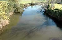
Mitchell River, Bairnsdale
A rock-ramp fishway has been constructed on the Bairnsdale barrage.
The upper reaches are the Wonnangatta and Wongungarra Rivers which join near Talbotville to become the Mitchell River.
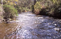
Wonnangatta River Junction to Lindenow
Flows for 60 km through forested mountains, with most of this length in a wide, steep-sided valley, then through the Mitchell River Gorge. Upstream of the gorge, riparian vegetation is willows, blackberry and tea-tree. Substrate is extensive areas of boulders and rubble.
There are extensive deep pools (with some sand substrate) separated by long riffles. Submerged logs, and deep pools provide the major instream habitat. In the gorge, there is a series of rapids and pools, with boulder and rock bottom, and fast-flowing water. Riparian vegetation is wattle and tea-tree scattered along the granitic bedrock. There are scattered patches of sand in some pools. Accessible by conventional vehicle to Tabberabbera and the Mitchell River National Park, where there are walking tracks to the river.
Access along the river is difficult upstream from Glenaladale. Contains brown trout, some to 2 kg, (av. 350 g), some rainbow trout to 1 kg, (av. 300 g), abundant Australian grayling, small river blackfish, congoli, short-finned and long-finned eel, Australian bass, common galaxias and Australian smelt. Fishing is most productive during the winter. Contains a self-sustaining population of trout and is not stocked. Willows have been removed and banks fenced and revegetated as part of the River Health Program.
Downstream of Lindenow
The river flows for 25 km through a wide flood plain used for grazing and cropping, through Bairnsdale and into Lake King. The channel downstream of Lindenow is very wide (20 m) with exposed gravel and rubble banks and extensive riffles and runs to 80-100 cm deep. Some reaches have extensive deep pools (200-400 cm). Riparian vegetation is grass, willows and occasional eucalypts.
Estuarine water is present downstream of the rock barrier at Bairnsdale. Here the banks are largely clear of trees or shrubs and the river is very accessible along its entire length, to the end of the silt jetties in Lake King. The lower reaches of fresh water downstream of Lindenow, contain the same species as upstream including Australian bass, as well as goldfish, European carp, flathead gudgeon, southern pygmy perch, shorthead lamprey and climbing galaxias. The largest brown trout are caught in this locality in July and August.
Estuary fish are present downstream from the rock barrier at Bairnsdale. The most common species are black bream (26-30 cm long) present in good numbers all year, yellow eye mullet, luderick, estuary perch, some flathead (particularly in autumn around The Cut), garfish (upstream at the Butter Factory Wharf) and abundant European carp. During summer, if flows are low and salinity increases, there can be a massive upstream movement of European carp, with large numbers of European carp congregating below the rock barrier. Black bream spawn in the estuary and large numbers of small fish are often present. As part of the River Health Program, a number of fishing platforms have been constructed, logs placed in stream as fish habitat, willows have been controlled, and banks protected and revegetated. Some of this work was funded by Recreational Fishing Licence revenue.
The Mitchell River received a stocking of Australian bass fingerlings, for the first time in 2010, when 15,000 fingerlings were released.
Moroka River, Dargo
Flows in forested mountains. A small stream that is relatively remote and not heavily fished. Accessible by 4WD vehicles. Low flow and water levels in summer. Carries small brown trout to 300 g and occasionally to 500 g. No other species have been taken in DSE surveys. Last stocked with trout by Victorian Fisheries Authority in 1969.
Prospect Creek, Bairnsdale
Small stream entering the Mitchell River near Bairnsdale. Silt and sand bottom. Seasonal fishing for congoli, and occasional brown trout. Also contains river blackfish, Australian grayling, common galaxias, southern pygmy perch and flathead gudgeon.
Victoria Lake, Loch Sport
11,500 ha, Ramsar listed
One of the Gippsland Lakes, surrounded by forest on the southern shore and scrub on the north. Boating facilities at Paynesville and Loch Sport. Carries black bream, mullet, flathead, silver trevally, whiting, river garfish and skipjack (tailor) as well as other estuarine species.
Wentworth River, Tabberabbera
Flows in forested mountains, gravel and boulder substrate. Access is difficult, but possible via mostly 4WD tracks running west from the Bullumwaal-Mount Baldhead Road, including Jones Road. Carries abundant brown trout to 450 g and abundant river blackfish, short-finned eel, congoli, Australian smelt and common galaxias. Reported to carry small rainbow trout. Last stocked with trout by Victorian Fisheries Authority in 1969. Willows have been controlled, and banks fenced and re-vegetated as part of the River Health Program.
Wongungarra River, Dargo
Flows in forested mountains, boulder and rock bottom. Width varies from 10-20 m with numerous pools to 200 cm. Accessible in upper reaches only by 4WD vehicle. Carries brown trout to 580 g, (av. 60 g), river blackfish, Australian grayling, short-finned eels and Australian smelt. Last stocked with trout by Victorian Fisheries Authority in 1978.
Wonnangatta River, Dargo
Upper reaches of the Mitchell River
Rises in forested mountainous country, (1,600 m altitude), flows through a forested gorge with some cleared river-flats in the middle reaches near Talbotville. Gravel and boulder bottom. Average width 10 m with pools to 100 cm deep. It can have low water flow and shallow water during summer. Accessible in the lower reaches by conventional vehicle but elsewhere by 4WD. Good fishing at times and becoming more popular as increasing numbers of people visit the Wonnangatta-Moroka National Park.
Carries abundant river blackfish to 1 kg with some fish to 2 kg, abundant small brown trout average 200 g, (max.1 kg), short-finned and long-finned eel, congoli, Australian grayling, common galaxias, mountain galaxias and Australian smelt. Last stocked with trout by Victorian Fisheries Authority in 1978. Willow control is taking place as part of the River Health Program. Some of this area was affected by 2006/07 fires.