Wild Trout Population Survey 2014
Results of wild trout population surveys in north east Victoria
Anglers in north east Victoria expressed concerns regarding the status of wild trout populations with reports of poor fishing across many streams, particularly during summer of 2013-14. In response, Fisheries Victoria commissioned Arthur Rylah Institute researchers to conduct population surveys of four trout streams in north east Victoria during February 2014. These streams were selected to broadly represent those North East streams where anglers reported poor angling catch rates in :
King River above and below Lake William Hovell
Howqua River upstream of Mansfield-Jamieson Road.
Jamieson River upstream of Jamieson.
Upper Goulburn River Jamieson to Woods Point.
Standard electrofishing methods and water quality monitoring were undertaken at 13 sites (Figures 1 and 2). The aim of the surveys was to assess the relative abundance and size of trout in the lower and upper reaches of each representative stream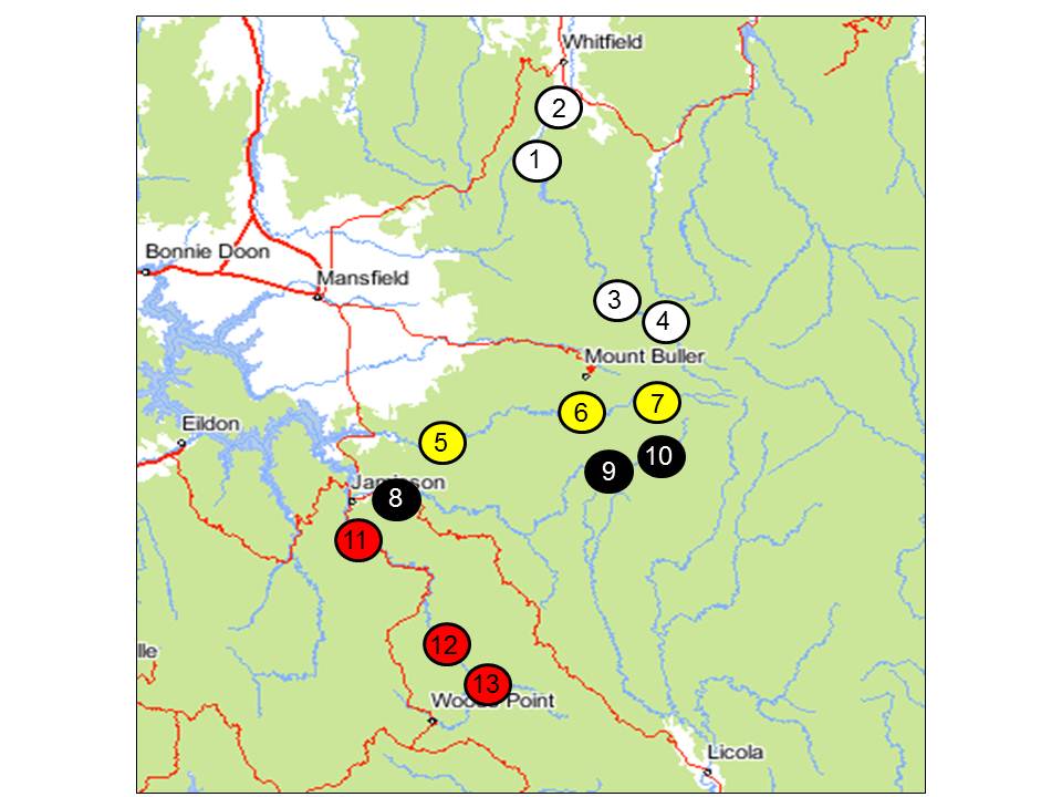
Figure 1. Location of 13 sites conducted during electrofishing survey (site names available in Table 1); white indicates sites surveyed on the King River, yellow indicates sites surveyed on the Howqua River, black indicates sites surveyed on the Jamieson River, Red indicates sites surveyed on the Upper Goulburn River.
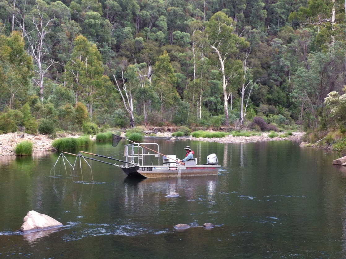
Figure 2. Arthur Rylah Institute researchers used boat (pictured) and backpack electrofishing to survey fish populations
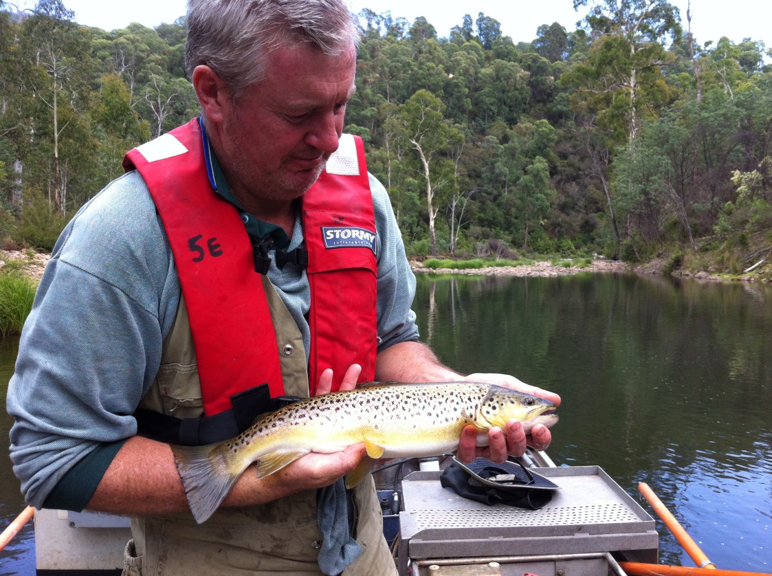
Figure 3.Arthur Rylah Institute researcher with a brown trout caught during the survey.
Survey results
Fourteen species were sampled during the survey, accounting for 857 individuals (Table 1). Brown trout were caught at 12 of the 13 sites and Rainbow trout were caught at 8 of the 13 sites surveyed.
Table 1. Total numbers of each species sampled across each site of entire survey.
Stream | King River | Howqua River | Jamieson River | U/Goulburn River | ||||||||||
|---|---|---|---|---|---|---|---|---|---|---|---|---|---|---|
Sites | 1 | 2 | 3 | 4 | 5 | 6 | 7 | 8 | 9 | 10 | 11 | 12 | 13 | Grand Total |
Two spined blackfish | 42 | 18 | 22 | 58 | 14 | 16 | 20 | 3 | 38 | 6 | 237 | |||
Brown trout | 3 | 3 | 25 | 21 | 1 | 10 | 32 | 12 | 29 | 3 | 19 | 41 | 199 | |
Redfin | 29 | 1 | 56 | 3 | 89 | |||||||||
Galaxias sp. 2 | 5 | 3 | 2 | 2 | 2 | 29 | 2 | 27 | 5 | 77 | ||||
Carp | 2 | 22 | 2 | 41 | 1 | 68 | ||||||||
Rainbow trout | 7 | 13 | 1 | 10 | 7 | 20 | 1 | 5 | 64 | |||||
Murray crayfish | 1 | 3 | 10 | 1 | 12 | 1 | 7 | 3 | 38 | |||||
Roach | 37 | 37 | ||||||||||||
Blackfish spp. | 32 | 32 | ||||||||||||
Yabby | 6 | 6 | ||||||||||||
Murray cod | 5 | 1 | 6 | |||||||||||
Spiny crayfish | 2 | 2 | ||||||||||||
Mountain galaxias | 1 | 1 | ||||||||||||
Big head gudgeon | 1 | 1 | ||||||||||||
Grand Total | 16 | 42 | 76 | 56 | 122 | 74 | 72 | 132 | 35 | 69 | 12 | 91 | 60 | 857 |
Overall, 199 brown and 64 rainbow trout were caught during the survey accounting for collectively over 30% of the total numbers of individuals sampled (Figure 4).
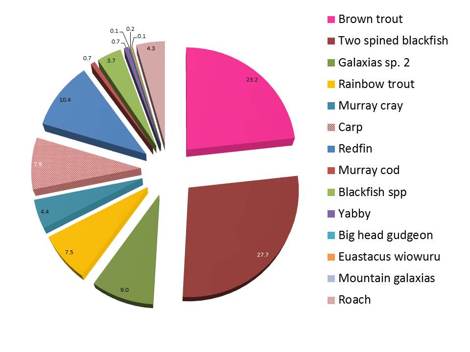
Figure 4. Percentage of each of the 14 species caught in the survey by numbers across all 13 sites.
Relatively low numbers of trout were recorded at the lower reaches (downstream sites) of all streams compared with upstream sites where relatively high numbers were recorded (Figure 5). Trout ranged from 6 to 56 cm in length. The numbers and sizes of trout recorded were indicative of past summer trout population survey results in these streams, although trout abundance in rivers can vary considerably between years.
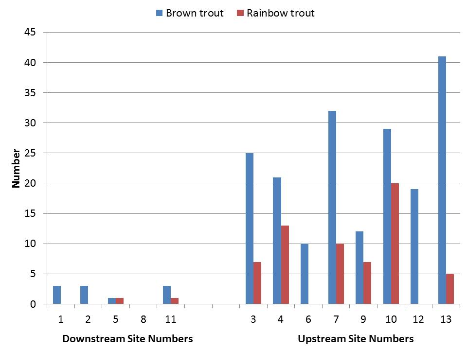
Figure 5. Number of brown and rainbow trout caught and observed at downstream sites and upstream sites respectively.
Relatively high water temperatures were recorded in all sites sampled, particularly in the lower reaches of each stream (Table 2).
Table 2. Water temperature and quality measurements from each of the 13 sites surveyed. *Note water temperature was taken at 8 am and stream temperature is expected to increase by a further 3 or 4 degrees throughout the day.
Site Number | River | Location | Temp. oC @ 8am* | Electrical Conductivity | Dissolved Oxygen (mg/L) | pH |
|---|---|---|---|---|---|---|
1 | King River | Downstream William Hovell | 19.1 | 17.7 | 9.45 | 7.86 |
2 | King River | Upper King Road | 17.9 | 17.2 | 9.74 | 8.46 |
3 | King River | King Basin Road | 15.9 | 12.7 | 9.70 | 7.16 |
4 | King River | Speculation Road | 15.9 | 12.7 | 9.70 | 7.16 |
5 | Howqua River | Steiners Road | 23.2 | 42.5 | 7.14 | 7.35 |
6 | Howqua River | Seven Mile Flat | 18.6 | 23.8 | 8.96 | 7.29 |
7 | Howqua River | Bindaree Road | 20.3 | 19.8 | 6.49 | 7.14 |
8 | Jamieson River | Jamieson Caravan park | 22.6 | 52.1 | 7.57 | 7.35 |
9 | Jamieson River North Branch | Saddle Road | 17.7 | 20.0 | 7.02 | 7.40 |
10 | Jamieson River North Branch | Brocks Road | 18.6 | 17.4 | 9.12 | 7.20 |
11 | Goulburn River | Kevington | 23.9 | 44.0 | 6.46 | 7.09 |
12 | Goulburn River | Clarke Spur Abbot Link Track | 22.4 | 40.0 | 9.15 | 7.31 |
13 | Goulburn River | Johnson Hill Track | 20.0 | 37.5 | 7.28 | 7.23 |
Discussion
Although a range of possible factors may have contributed to the trout population results observed, the most likely cause of low trout abundance in lower reaches of north east Victorian streams is high water temperatures associated with high ambient temperature and low summer stream flows.
As trout are a cold water fish species, they are physiologically vulnerable to warm water and impacts can occur on feeding, growth, survival, reproduction and catchability by anglers. Water temperatures recorded during the survey were at or above the thermal tolerance of trout. Additionally, the Bureau of Meteorology suggests;
- Since 1996, North East Victoria has experienced on average the lowest stream flows on record (refer figure 6),
- In the summer of 2013/14, there were record numbers of days where air temperature was above 25 degrees (recorded at Mt Buller),
- Victoria experienced a particularly dry and hot month in January 2014 with higher than average maximum temperatures felt throughout a significant heatwave event.
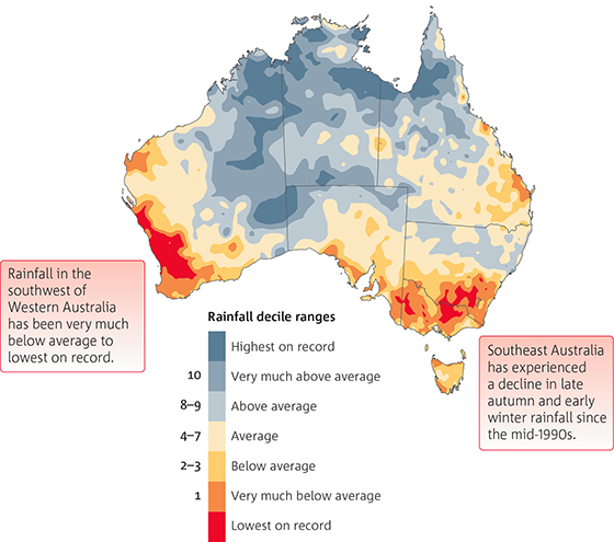
Figure 6. Rainfall deficits throughout Australia Southern wet season (April–November) rainfall deciles since 1996 in comparison with the entire rainfall record from 1900. (Source: BoM State of Climate 2014 report)
In response to high summer water temperatures, trout may reduce feeding and actively avoid warm water by moving away to cooler water areas such as upstream or to deeper water (Lake Eildon).
A range of other factors have also been suggested as contributing to low trout abundance in lower reaches of north east Victorian streams. These include stream habitat condition, fishing pressure, predation by other species (e.g. cormorants) and competition with other species (e.g. carp). In response to these suggested factors, it is worth noting;
- Stream habitat condition is in the streams surveyed is regarded as 'good' to 'excellent' (Index of Stream Condition).
- Fishing pressure in the north east streams has not been quantified but compliance and anecdotal reports suggest recreational fishing influence on trout populations is unlikely to explain low trout abundance in the lower reaches.
- There were reports of high numbers of cormorants sighted in north east Victoria, although their effect on trout populations has not been quantified.
- Carp were only recorded in moderate abundance in the survey (n=68) including at 5 of 13 sites sampled. Their impact on stream dwelling trout is not well understood.
Angler Engagement
The results of this survey were presented to:
- A meeting with 12 representatives of trout fishing organisations at Fisheries Victoria's Snobs Creek Hatchery on 3 April 2014. This group agreed to act as a reference group to consider future research and development proposals.
- A public forum open to all interested parties (attended by approximately 70 participants) at Alzburg Resort, Mansfield on 10 April 2014.
At both meetings, there was considerable discussion about what, if any, fisheries management interventions could be adopted to better understand how the fishery is performing and improve its performance.
Where to from here
High levels of angler concern about the status of river trout fishing in North East Rivers and the social and economic contribution that trout fishing makes to the regional economy warrants further attention.