Werribee - Angling Waters
View Werribee River Basin in a larger map (opens new window).
The above map is provided by Google. The department accepts no responsibility for its accuracy or content.
Cherry Lake, Altona
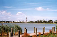
48 ha. Boardwalks, boat ramp, picnic facilites, barbecues, bird hide, playground. The lake is managed by Melbourne Water and the reserve by Hobsons Bay City Council.
A very shallow (<1 m) former swamp converted into a flood control basin and developed as a recreational area. Good for bird watching. The lake carries some European carp to 6 kg, goldfish, redfin to 1 kg, short-finned eel to 1.5 kg, roach, common galaxias and smallmouth hardyhead. Stocking with a wide variety of native and introduced species has not produced significant returns in the past. The lake is fished mainly by children and locals and is used for general picnicking and windsurfing.
Colbrook Reservoir, Ballan
Managed by Central Highlands Water.
A small storage on the Korweinguboora Creek approximately 8 km north of Ballan. Access road is not suitable for conventional vehicles in wet weather. Stocked approximately every three years with brown trout.
Darlingsford Lake, Melton
Melway Ref: 337 C11.
A small water set in parkland on the SE fringe of Melton (Tullidge Street Reserve). Previously managed as a Family Fishing Lake.
Djerriwarrah Reservoir, Melton
1,068 ML.
A domestic water storage managed by Western Water and closed to fishing.
Djerriwarrah River, Melton
A small creek 2-3 m wide, with pools to 70 cm deep. Good riparian vegetation. Contains redfin, roach, a good population of Australian smelt, also mountain galaxias, and southern pygmy perch. Annual diversion into the reservoir is capped at 40 ML/year. Not recognised as an angling water.
Exford Weir
see Melton Reservoir
Kororoit Creek, Deer Park
A small creek flowing for 4 km in flat cleared farmland. The creek is 2 m wide with pools to 70 cm deep and contains a surprising number of fish species including estuarine fish such as flounder, black bream and yellow eye mullet in the lower reaches. The freshwater section has short-finned eel, tench, common galaxias, flathead gudgeon, southern pygmy perch, southern longfin goby, goldfish, congoli and eastern gambusia. It is not recommended as an angling water.
Lerderderg River, Bacchus Marsh
There is a vertical slot fishway on the diversion weir within the gorge.
The river rises in forested hilly country north west of Blackwood and then flows for 30 km through the Lerderderg Gorge. Average channel width is 5 m. There are numerous shallow riffles with pools to 120 cm deep in the gorge area. Substrate in the riffles is gravel and rubble with fast water velocity. The river is in good condition and provides a natural and scenic environment.
The river is accessible from walking tracks along much of its length but there is no vehicle access to the gorge. The road into the diversion weir is locked. There are good numbers of small brown trout (10–25 cm) around Blackwood and upstream of the junction of Goodmans Creek. Other fish species in this section are river blackfish, roach, short-finned eel, mountain galaxias, common galaxias and Australian smelt. There is a diversion weir in the Gorge that diverts water to Merrimu Reservoir via Goodmans Creek. An environmental flow of 30-50 ML/d is maintained, when possible, by Gippsland and Southern Rural Water downstream of the weir.
The short section of the river below Goodmans Creek is wider and shallower than upstream and usually has a low flow or sometimes no flow during summer. Fish are tench, goldfish, redfin and roach. The river was stocked with trout many years ago but it has been established that natural spawning is adequate to maintain the fishery. Goodmans Creek contains short-finned eel and mountain galaxias.
Melton Reservoir, Melton
320 ha. 17,000 ML. Boat ramp, picnic facilities.
Also known as Exford Weir and managed by Gippsland & Southern Rural Water.
Water from the reservoir is released into the Werribee River and diverted from the Werribee Weir, just upstream of Werribee township, to irrigate the market gardening area. Surrounded by grazing land, mud bottom. Contains some redfin, short-finned eel, tench, goldfish, European carp and roach. Provides poor angling and is considered mainly a boating lake. Not stocked.
Merrimu Reservoir, Bacchus Marsh
310 ha. 35,000 ML. Managed by Gippsland & Southern Rural Water.
A deep, domestic water storage surrounded by grazing land. There are picnic facilities but boating swimming, camping and fishing are prohibited.
Navan Park Lake, Melton
Family Fishing Lake. Water, toilets, BBQ's. Melway Ref: 336 H5.
A small water set in parkland on the NE fringe of Melton off Coburns Road. Managed as a Family Fishing Lake and stocked with advanced yearling rainbow trout (See Introduction).
Pykes Creek Reservoir, Ballan
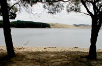
20 ha. 24,000 ML. Boat ramp, toilets, picnic facilities. Managed by Gippsland and Southern Rural Water.
An irrigation storage supplying water to the Bacchus Marsh and Werribee areas. Surrounded by grazing land, clay bottom. Excellent access. A popular recreational boating water. Carries abundant small redfin to 350 g, some to 600 g, roach, European carp to 5 kg, tench, some short-finned eel and a self sustaining brown trout population with fish to 1.5 kg. Not stocked. Popular fishing methods include fly fishing, spinning with lures or bait fishing with worms, maggots and yabbies, usually on the bottom. Redfin tend to be small, but small numbers of good-sized brown trout can be taken at times.
Werribee River, Bacchus Marsh
Rises in the Wombat State Forest south of Daylesford and flows for 110 km to Port Phillip Bay. It passes through the town of Ballan, where water is diverted to Pykes Creek Reservoir, then flows through the Werribee Gorge to Bacchus Marsh. Here water is diverted to the Dairy Factory and for irrigation. It then flows into Melton Reservoir. Further downstream flow is regulated. Water is released downstream during summer and in dry years to the Werribee Weir, located just upstream from the town of Werribee, for irrigation of market gardens.
Flow in the 20 km of river between Melton Reservoir and Werribee Weir therefore varies from very high flows during irrigation releases to very low flows at other times. Diversion of water at the Weir results in low flows downstream to Port Phillip, although groundwater inflow usually maintains a small flow.
Ballan to the Werribee Gorge
The river flows for 15 km in rolling farmland, with basalt outcrops. River width at Ballan is from 2-5 m. Much of the river is shallow and the bed is exposed with little fish cover during low flows. However there are some good pools 80-120 cm deep with good fish habitat. Substrate is rubble and gravel. Riparian vegetation is restricted to some willows. Some trout spawning occurs further upstream in the headwaters where habitat is suitable. A few deep pools at Ballan provide some angling for small brown trout, redfin and river blackfish. Some of the small-sized fish species occurring downstream will be present in the upper reaches but no fish surveys have been carried out in that area.
From top of Werribee Gorge to a diversion weir 2 km upstream of Bacchus Marsh
The river flows through forest and grazing land in a steep-sided valley. Gravel and rock bottom. There is good access to the Gorge and there are picnic facilities. The river is deeply entrenched in the rocky-gorge section and consists of some shallow riffles, but mostly very extensive deep pools, with slow turbid water. These pools have never been surveyed for fish but the remainder of this section of the river is known to contain brown trout to 800 g (av. 300 g), abundant redfin to 200 g, river blackfish, tench and roach. Other species likely to occur are Australian smelt, flathead gudgeon, trout galaxias and mountain galaxias.
Bacchus Marsh to Melton Reservoir 6
This consists of a 10 km reach of river. There is extensive shallow water at Bacchus Marsh with pools 80-100 cm deep and some sedimentation. Further downstream there are some good pools to 150 cm deep. Substrate is rubble, sand, silt and clay. Fish populations have not been surveyed but are likely to be similar to those upstream.
Melton Reservoir to Werribee Weir
The river flows for about 20 km through farmland, in a deeply-entrenched basalt channel in low hills, then through the Werribee Plains with unconsolidated silt, gravel and sand soils to Werribee Weir. This weir has little storage capacity and is used as a diversion point for irrigation of market gardens. Riparian vegetation is often sparse with only a thin strip of riparian vegetation near Werribee. Best access to the river is just below Melton Reservoir and a large reserve area at Cobbledick Ford Road. Flow through this section of the river is limited by release of water from Melton Reservoir.
In spite of this, the prevalence of wide, deep pools maintains good habitat and fishing opportunities even when little water is being released. Angling fish are European carp, roach, redfin and some brown trout. Other species are tench, Australian smelt, common galaxias, blackfish, short-finned eel, eastern gambusia and flathead gudgeon. The first kilometre of the river below Melton Reservoir is very accessible by walking along the bank and is the most heavily fished. Scrubworms are a good bait for redfin and corn and dough is effective for European carp.
Downstream of Werribee Weir to Werribee
During summer or when irrigation diversion from the Werribee Weir is occurring, flow through Werribee can be extremely low. The riffles are shallow with exposed basalt rubble substrate. However there are some extensive pools to 5 m deep above Cottrell Street Ford, the former swimming hole (Bungles Hole) and the Pioneer Settlement Park that retain water and can be fished for redfin to 300 g, short-finned eel, and brown trout to 400 g (av. 120 g). Also contains European carp, congoli, goldfish, pouch lamprey, shorthead lamprey, congoli, common galaxias, tench, roach, flathead gudgeon, Australian smelt and eastern gambusia.
Below Werribee
There is a short length of fresh water from Werribee to the ford behind the Werribee Mansion. This is rather inaccessible but contains extensive pools up to 6 m deep. Below the ford the river is estuarine and carries black bream to 1.3 kg, mullet, trevally, flathead and flounder. Best access for shore fishing in the estuary is the lower western shore via the Melbourne Water farm (permit to enter the farm required). There is some shoreline and jetty fishing at Werribee South and the lower river section can be reached by boat from Port Phillip Bay or the Werribee South boat ramp. Successful baits for black bream are bass yabbies, and sandworms. Fish such as blue-bait, whitebait and pilchards are successful for flathead which enter the estuary in spring. The lower Werribee River provides excellent fishing for black bream at times.