Thomson - Angling Waters
View Thomson River Basin in a larger map (opens new window).
The above map is provided by Google. The department accepts no responsibility for its accuracy or content.
Aberfeldy River, Aberfeldy
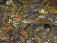
A clear wide (10-15 m) mountain stream running through steep forest. Substrate is rock, rubble and gravel with areas of exposed stream bed and gravel banks. Extensive shallow riffles are separated by pools over 100 cm deep. Most of the river is wadeable. Joins the Thomson River downstream of Thomson Reservoir. Access by conventional vehicles limited to the Walhalla/Aberfeldy Road (a narrow, gravel road) and track crossings for 4WD vehicles.
Some off-road tracks may be closed during the winter. Provides an enjoyable and natural setting. Contains brown trout to 600 g, short-finned eel, river blackfish, Australian smelt and occasional rainbow trout.
Avon River, Stratford

A broad (16-50 m) shallow stream flowing from a forested wilderness area in the upper reaches, through flat open farmland. Substrate varies from rock and rubble upstream to extensive exposed gravel banks and small areas of sand, in the lower reaches, originating from severe channel erosion and stream deposition. There are very extensive pools more than 150 cm deep along the river.
These are separated by shallow (20-40 cm) fast flowing riffles. There is little instream habitat because of frequent flood events and fast-flowing water due to the high gradient of the river. Access to and along the river is good. Above Stratford, contains some brown trout av. 170 g, (max. 600 g), Australian grayling, short-finned and long-finned eel, European carp, some redfin and a good population of Australian bass. Other fish are common galaxias, eastern dwarf galaxias, flathead gudgeon and southern pygmy perch.
Last stocked with trout by Fisheries Victoria in 1969. The estuarine area extends for several kilometres upstream of the mouth and contains some black bream, abundant estuary perch, luderick, sea mullet, yellow eye mullet, Australian smelt, flathead gudgeon and southern pygmy perch. Fishing platforms have been constructed by the Catchment Management Authority with support from Recreational Fishing Licence revenue. Banks have also been fenced and revegetated and access tracks improved.
The Avon River received a stocking of Australian bass fingerlings, for the first time in 2010, when 15,000 fingerlings were released.
Barkly River, Glencairn
A very fast flowing river in steep forested country, rock and gravel substrate. A small river subject to wide fluctuations in flow. Access is limited to road crossings because of steep forested terrain. Not heavily fished because of the limited access and more accessible fishing waters nearby. Contains brown trout to 750 g (av. 95 g), some small rainbow trout to 200 g, possibly short-fined and long-finned eel, river blackfish to 200 g (av. 20 g), Gippsland spiny crayfish and redfin to 200 g. Self-sustaining trout population. Not stocked.
Cowwarr Weir, Cowwarr
Picnic facilities, non-powered boats only permitted. A rock-ramp fishway has been constructed.
A small weir, which regulates releases down the Rainbow Creek with the objective of maintaining maximum possible flow in the Thomson River. The Weir is very accessible around its banks. No boat ramp. Contains some brown trout, European carp to 4 kg and redfin. Fish from downstream can bypass the Weir and move upstream into the upper Thomson River. A rock ramp fishway was built on the weir in 2000 and its design was improved in 2008. Last stocked with trout by Fisheries Victoria in 1991 but receives sufficient fish from the Thomson River.
Freestone Creek, Valencia Creek
A small, highly silted stream with limited access. Poor habitat values and not recommended as an angling water.
Glenmaggie Lake, Glenmaggie
176 ha. 124,020 ML. Caravan, camping and boat launching facilities.
An irrigation storage on the Macalister River surrounded by cleared and forested land. Level fluctuates widely and the lake is drawn down to very low levels in most years. Substrate is mainly mud with little aquatic vegetation. Carries predominantly European carp to 5 kg, (av. 800 g), redfin to 1 kg, (av. 400 g), some brown trout to 1.2 kg, (av. 300 g), rainbow trout to 350 g, short-finned eels, Australian bass and goldfish.
Bank fishing is successful when levels are adequate. Fishing for redfin is best in the spring and early summer. Despite regular stocking with brown trout, catches have declined severely when compared with fishing in the 1970s. Possible reasons are increased fluctuations in water level, significant sediment inputs from upstream erosion and competition with European carp and redfin. Stocked regularly with rainbow trout and sometimes also with brown trout. Australian bass are also stocked.
Glenmaggie received 22,000 bass towards the end of 2010. It also received 30,000 the previous summer, providing two consecutive year classes in this water.
Guthridge Lake, Sale
28 ha, Family Fishing Lake, toilets, picnic tables.
A small lake situated within the town at the southern end of the main business district. Shallow with a mud substrate. Contains European carp, short-finned eels and goldfish. Managed as a Family Fishing Lake and stocked with advanced yearling rainbow trout (See Introduction).
Guyatt Lake, Sale

Family Fishing Lake, no facilities
Not on the map but located immediately south of Lake Guthridge. A small lake managed as a Family Fishing Lake and subject to stocking with advanced yearling rainbow trout (See Introduction).
Heyfield Racecourse Dam
Family Fishing Lake. No facilities, fishing platform.
Not on the map, but located at the SE end of the racecourse. An all-access fishing platform will be built in 2008 using Recreational Fishing Licence revenue. Small water managed as a Family Fishing Lake and stocked with advanced yearling rainbow trout (See Introduction).
Jordan River, Aberfeldy
A small (5 m wide) clear, fast-flowing stream running through steep forested country, rock and gravel bottom. Access limited to road crossings and forestry tracks. Numerous deep holes (>100 cm) but most of the river is wadeable. Contains brown trout to 600 g, a few rainbow trout, short-finned eel and river blackfish over 350 g in the upper reaches. Last stocked with trout by Fisheries Victoria in 1962.
Macalister River, Maffra

Above Lake Glenmaggie
Headwaters in forested mountains, with extensive deep pools and fast runs, rock and rubble bottom. Downstream from Licola, the gradient decreases and the river becomes wider and slower. Near Mt Useful Creek (15-20 km upstream of Lake Glenmaggie) the river flows through farmland with riparian vegetation of grass and willows on one bank and forest on the other bank.
There are wide pools separated by substantial riffles. Substrate is rock, rubble and gravel. Further downstream, the banks are more eroded resulting in the pools becoming filled with sediment. There are wide fluctuations in flow and water level and very high turbidity during floods. As part of the River Health Program, willows have been removed and banks have been fenced, revegetated and stabilized.
Contains brown trout to 750 g, numerous redfin to 400 g, (av. 120 g), river blackfish to 100 g, Gippsland spiny crayfish, European carp to 2.2 kg and possibly some short-finned and long-finned eels. Best fishing is in spring and autumn. Stocked regularly with rainbow trout by The Victorian Fisheries Authority. A recent creel survey to evaluate the contribution that these fin-clipped trout make to the fishery showed that although a reasonable proportion of stocked fish were recaptured, the fishery is supported largely by self-maintaining populations of both brown trout and rainbow trout. In spite of significant environmental impact from fire and flood events, the fishery has survived at a reduced level and the river is showing strong signs of recovery.

Below Lake Glenmaggie
Flows through farmland, with riparian vegetation varying from some forested sections with wattles and eucalypts and other sites with grass and willows. There is a River Health Program to reduce nutrient run-off from the irrigation area. Substrate is rubble and gravel and areas of sand or mud. Water type is fast runs and riffles with slow flowing pools. Carries brown trout av. 300 g, (max. 1.6 kg), also redfin av. 100 g, (max. 700 g). Short-fined eel and European carp to 2.7 kg are common in the lower reaches.
The river immediately below the Lake Glenmaggie wall produces very good brown trout in spring and autumn. Stocked regularly with brown trout by The Victorian Fisheries Authority.
The Macalister River below Lake Glenmaggie was stocked with 4,000 Australian bass in 2010.
McLennan Strait
Connecting channel between Lake Wellington and Lake Victoria in the Gippsland Lakes. Contains black bream, yellow eye mullet, tailor, estuary perch, Australian bass, short-finned and long-finned eel, European carp, congoli, abundant Australian smelt and flathead gudgeon.
North Cascade Creek, Thomson Reservoir
A small fast-flowing tributary of the Thomson River, running into the western side of the Thomson Reservoir, through native forest. Access is from the Thomson Valley Road. Width is 2-3 m with cascades and rapids and shallow water less than 50 cm deep. Sand and boulder substrate. Contains small brown trout and rainbow trout.
Perry River, Perry Bridge

Flows through flat farmland. Good riparian vegetation and aquatic habitat. The freshwater section dries up in some years but there is always some fishing near the mouth for estuarine species such as estuary perch, black bream, mullet and luderick. Contains European carp, short-finned and long-finned eel, common galaxias, eastern dwarf galaxias, climbing galaxias, goldfish, southern pygmy perch and flathead gudgeon.
Rainbow Creek, Cowwarr
An anabranch of the Thomson River formed by floods in 1952. Most of the stream flows through flat farmland and access is limited to road bridges. Channel width is 10 m but the wetted area is often much narrower. Riparian vegetation is grass, willows and planted native trees. Rock and gravel substrate and some deep pools over 100 cm. Wide fluctuations in water level and flow and flash floods are common. Suitability for fishing is limited by the low flows, which are imposed on the river, whenever possible, to minimise further erosion.
Contains redfin to 340 g, (av. 220 g), brown trout to 400 g, average size very small, European carp to 4.8 kg, (av. 1.4 kg), congoli, abundant river blackfish to 80 g, Australian grayling, Australian smelt and southern pygmy perch. Was stocked during the 1990s with fin-clipped brown trout. Last stocked with trout by Fisheries Victoria in 1997.
Rawsons Dam, Rawson
A small water which used to be part of the Family Fishing Lakes Program but has since been withdrawn.
Shaw Creek, Glencairn
A small, fast, clear tributary of the Macalister River flowing through remote, dense forest and open farmland. Gravel and mud bottom. Low summer flows are common. Popular for fly fishing due to a healthy population of small trout which rise well to a fly and the ease of casting on the button grass plains through which the river flows. Contains abundant brown trout to 320 g and occasionally to 600 g, (av. 100 g), some small rainbow trout and short-finned eels. Access is limited and difficult, requiring local knowledge. Last stocked with trout by Fisheries Victoria in 1983.
South Cascade Creek, Thomson Reservoir
A small (2 m wide) fast-flowing tributary of the Thomson River. Runs into the western side of the Thomson Reservoir through pristine native forest. Cascades and rapids with shallow water and a boulder and sand substrate. Contains abundant small brown trout and rainbow trout. Fishing is not permitted within 200 m of the full supply level of the reservoir.
Stratford Reservoir, Stratford
1 ha.
Not shown on map.
A small storage surrounded by flat, partly timbered country. Contains mainly short-finned and long-finned eel. Last stocked with trout by Fisheries Victoria in the 1960s but produced poor results.
Thomson Reservoir, Walhalla

2,200 ha. 1,123,000 ML. Domestic water storage - NO FISHING
A major storage constructed on the Thomson River upstream of its junction with the Aberfeldy River. The Thomson Reservoir is a domestic water supply reservoir, part of Melbourne's water supply and managed by Melbourne Water. The reservoir and all inflowing waters within 200 m of the full supply level are closed to fishing and public access. It provides water to Melbourne via a tunnel to the Upper Yarra Reservoir and also releases irrigation water downstream to Cowarr Weir for Gippsland.
Thomson River
A rock-ramp fishway has been constructed at Easton Weir.
Above Thomson Reservoir
A clear fast-flowing stream running through steep forests. River width is 4-8 m. It is predominantly shallow riffles but there are numerous deep pools and gutters over 100 cm deep. Rock, rubble and coarse gravel bottom. Most of the river is wadeable. Access limited to road crossings and forestry tracks and many of the smaller tracks are subject to a seasonal closure from May to November. A good fishing environment, with large brown trout from the reservoir entering the river during May/June. Contains brown trout to 1.2 kg, a few rainbow trout, river blackfish up to 500 g and used to contain short-finned eels (juvenile eels returning from the sea would now find it impossible to pass upstream over the reservoir wall).
Thomson Reservoir to Cowwarr Weir
Flows the entire length through steep forests with dense native riparian vegetation. There has been removal of willows over a substantial length of the river as part of the River Health Program. Banks have also been revegetated, fenced and stabilized where necessary. Channel width varies from 6-14 m downstream of the dam to 20-40 m at Bruntons Bridge. There are extensive reaches of fast water and riffles, and numerous deep pools usually at least 150 cm deep and often up to the maximum depth recorded in the river, of 490 cm at Bruntons Bridge. Substrate is almost all a mixture of rock, boulders, rubble and gravel, with small areas of sand in the pools or on bends. Access is limited to a few road crossings. There is access by conventional vehicle to downstream of the dam, to the flow gauging station (off the Narrows Track), Walhalla, Coopers Creek and Bruntons Bridge.
The Low Saddle Track (off the Narrows Track), is accessible only by 4WD because of its steep gradient. The best fishing area is from the dam wall downstream along the Narrows Track/Road, but some walking is necessary to reach most of the river. Carries some brown trout to 1.5 kg but mostly smaller, good numbers of large river blackfish to 800 g, short-finned and long-finned eel, congoli, small Gippsland spiny crayfish, Australian smelt, common galaxias, pouch lamprey, shorthead lamprey, southern pygmy perch and occasional Australian grayling downstream of the Walhalla Road bridge.
Platypus are abundant. The numbers of all fish are low at the Coopers Creek and Bruntons Bridge road crossings and these are not good fishing areas although the latter site is a very good picnic/camping area (no facilities). Operation of the reservoir has evened out most of the fluctuations in flow. A designated Environmental Water Reserve has been allocated an additional annual flow of 10,000 ML to improve environmental values, and a further 8,000 ML will be made available in the future. Last stocked with trout by Fisheries Victoria in 1969.
Below Cowwarr Weir
Flows through flat farmland and discharges into the La Trobe River upstream of Lake Wellington. Has deep pools with slow runs and occasional riffles. Turbid water, sand and gravel substrate. Instream logs, willow roots and patches of instream vegetation provide fish cover. Riparian vegetation is river red gums and willows. Contains some brown trout av. 220 g, (max. 750 g), some river blackfish, short-finned and long-finned eel, Gippsland spiny crayfish, European carp, congoli, redfin, Australian grayling, Australian smelt, common galaxias, flathead gudgeon, and southern pygmy perch. There are estuary perch in the lower reaches near the La Trobe River. Last stocked with trout by Fisheries Victoria in 1969.
The Thomson River received a stocking of Australian bass fingerlings, for the first time in 2010, when 11,000 fingerlings were released near Cowwarr Weir.
Valencia Creek, Valencia Creek
Flows through forested hills, rock and gravel bottom. A small stream and its deeper sections have silted up, reducing its value as fish habitat. Subject to wide fluctuations in water level and flow. Contains a few brown trout usually less than 220 g but some to 700 g, short-finned and long-finned eel, Gippsland spiny crayfish, river blackfish and congoli. Last stocked with trout by Fisheries Victoria in 1969.
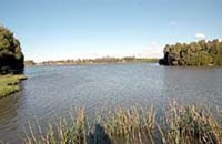
Wellington Lake, Sale
14,000 ha. Ramsar listed
The largest, shallowest and least saline of the Gippsland Lakes. Main species are European carp to 11 kg, mullet, estuary perch, both species of eel and very occasionally brown trout.
Wellington River, Licola
A fast flowing, shallow stream running through forested mountains, rock and gravel bottom. Water level and flow fluctuate. Lower reaches are readily accessible and popular for trout fishing. Contains predominantly small brown trout, maximum 325 g, small rainbow trout, short-finned and long-finned eel, abundant river blackfish, Australian smelt and small Gippsland spiny crayfish. Last stocked with trout by Fisheries Victoria in 1983.
Whitelaw Creek, Thomson Reservoir
Not shown on map.
A small fast flowing tributary of the Thomson River headwaters. Access is limited. Contains abundant small brown trout.