South Gippsland (West) - Angling Waters
View South Gippsland (West) Basin in a larger map (opens new window).
The above map is provided by Google. The department accepts no responsibility for its accuracy or content.
Bass River, Bass
A narrow fast-flowing stream rising in steep cleared country, rock and sand bottom. Downstream from Almurta, the terrain is relatively flat farmland. The river becomes wider (5-7 m) but is fairly shallow with extensive areas less than 60 cm deep in summer with pools and gutters to 100 cm. Substrate is soft mud over a hard clay base.
There is often dense riparian growth of willow trees with some encroachment by them into the channel. Submerged aquatic vegetation is abundant. The lower reaches are subject to flooding after heavy rain. Contains short-finned eel, common galaxias, trout galaxias and some congoli with an occasional large sea-run brown trout in the lower reaches.
River blackfish, goldfish and flathead gudgeon are reported to occur but have not been taken in surveys. The estuarine section is accessible at the Bass Landing Road. The estuary is surrounded by flat, open land and can be easily fished from the banks. Water is 15-20 m wide with depths over 100 cm. Small boats can be launched over the bank. Carries some Australian salmon, estuary perch, flounder and yellow eye mullet.
Berrys Creek, Mirboo North
A major tributary of the West Branch of the Tarwin River. Flows through moderately sloping farmland in its upper and middle reaches onto flat farmland near the Leongatha/Mirboo Highway. Riparian vegetation is willows in the upper and lower reaches and willows and eucalypts in the middle reaches. Channel width varies from 2-6 m upstream to 3-8 m downstream. The section around Watts Bridge consists of riffles 10-30 cm deep with small pools 60-100 cm deep.
The middle reaches (Moirs Bridge) have extensive pools to 110 cm in depth, with extensive, deeper pools near the main highway. Substrate is gravel and rubble upstream, and soft mud and some sedimentation downstream. The creek has areas of good habitat and some promising fishing water. Accessible at road bridges (Watts, Moirs Roads & Main Strzelecki Highway) or through private property.
Fish present are predominantly brown trout (av. 225 g), maximum 900 g, a few rainbow trout of similar size, small river blackfish, European carp, redfin, short-finned eel, southern pygmy perch and common galaxias. Last stocked with trout by Fisheries Victoria in 1969.
Elizabeth Creek, Allambee South
Not shown on map.
Small upper tributary of the Tarwin River. Flows through scrub covered hills, rock and gravel bottom. Access is restricted by private property. Predominant fish are brown trout to 350 g, (av. 100 g) some river blackfish and congoli; also short-finned eel, common galaxias, pouch lamprey and Australian grayling.
Korumburra Reservoirs, Korumburra
There is a series of three domestic water storages, surrounded by steep farmland and controlled by South Gippsland Water Authority. Reservoirs 1 & 2 are located on Coalition Creek; Reservoir 3 is on Bellview Creek. Access is available only to members of the Korumburra Angling Club and because of this restriction of public access, stocking was discontinued in 1988.
Coalition Creek is 1-3 m wide, with pools to 70 cm and a rock, sand and rubble substrate. Bellview Creek flows through open farmland. The lower reaches have good bank vegetation, pools to 100 cm and a bottom of clay and woody habitat. Flow in both these creeks is influenced by the reservoirs but they have good instream fish habitat and permanent water in the lower reaches. Fish species are likely to be those present in nearby waterways into which these creeks flow.
Lance Creek, Wonthaggi
A small (1-4 m wide) creek with high steep banks. Downstream of the Lance Creek Reservoir it is deeply entrenched in flat farmland, with riparian vegetation of swamp paperbark, blackberry and wattles. It has riffles to 20 cm deep, and small pools to 70 cm. Mud substrate. Good habitat for small native fish but of no angling value. No information on fish species present, but probably includes short-finned eels and redfin.
Leongatha Reservoirs, Leongatha
These are four domestic storages located on Ruby Creek and situated in steep gullies in open hilly country. Reservoir 1 (36 ML); Reservoir 2 (182 ML); Reservoir 3 (800 ML) also called Sir Herbert Hyland Dam; Reservoir 4 called Western Reservoir (1,137 ML). Access is available only to members of the Leongatha Angling Club with a total closure to angling during the summer fire period. Because of this restriction of public access, Fisheries Victoria stocking was discontinued in 1988.
Little Bass River, Poowong
A tributary of Bass River not marked on the map.
Flows in steep and undulating cleared farmland. Up to 4 m wide downstream with pools to 110 cm and riffles to 20 cm. Rubble, gravel and sand substrate with areas of woody habitat. Contains some brown trout and short-finned eel. Also possibly other species that occur in the Bass River.
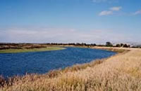
Poowong Reservoir, Poowong
A small deep storage on the Bass River surrounded mainly by open land and owned by the Poowong Butter Factory and controlled by the Poowong Angling Club. Only Club members can fish this water and for this reason, Fisheries Victoria stocking was discontinued in 1988.
Pound Creek, Inverloch
A short stream 6 m wide, flowing through flat farmland, aquatic vegetation. Flows into Andersons Inlet and is only worth fishing immediately above the Inlet, where estuary perch to 1 kg can be taken occasionally.
Powlett River, Outtrim
A narrow stream rising as many tributaries in steep inaccessible farmland. In the lower reaches (upstream of Bass Highway) flows sluggishly through flat farmland and has steep banks and a mud substrate. Width is 6-8 m with dense riparian vegetation of swamp paperbark (Melaleuca). Water depth averages 60 cm with pools over 100 cm. Good habitat and fish cover. Floods regularly and is usually discoloured, except during periods of low flow. Contains some brown trout to 400 g, (av. 120 g) where habitat is suitable, short-finned eel, common galaxias, congoli, goldfish, and flathead gudgeon.
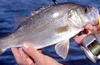
Estuarine section is popular with anglers and produces black bream in excess of 1 kg, yellow eye mullet, sea mullet, flounder, and some estuary perch.
Saltwater Creek, Ventnor
Not shown on map, located close to Cowes.
A short stream which at times carries reasonable numbers of black bream to 900 g, yellow eye mullet and short-finned eel.
Screw Creek, Inverloch
A short stream draining into Andersons Inlet. Tidally affected up to the Inverloch/Venus Bay Road. Here it is 7 m wide, and up to 200 cm deep with riparian vegetation of swamp paperbark. Good instream habitat and bank fishing is possible. Contains the same estuarine fish as the Inlet with occasional estuary perch to 1 kg, (av. 670 g) and small black bream.
Swan Lake, Phillip Island
32 ha.
Not shown on map, but situated northeast of the Penguin Parade area. A shallow lake with heavy weed growth accessible by an unmade road. Stocked with trout in the 1970s but did not produce worthwhile results and is not recommended as an angling water.
Tarwin River East Branch, Dumbalk
From Mirboo North to junction with West Branch. The section of the river above Mirboo North is in the eastern section of this basin.
A 15 km section of river flowing through rolling cleared farmland with riparian vegetation of mostly willows and some eucalypts. At Dumbalk, the river is up to 12 m wide with slow flowing water and deep pools over 200 cm deep, mud and sand bottom. Access is restricted by private property. Contains brown trout av. 100 g, some 400 g with occasional larger fish, river blackfish, short-finned eel, southern pygmy perch, Australian smelt, common galaxias and congoli. This water is no longer stocked due to the presence of a native fish species listed in The Flora and Fauna Guarantee Act 1988 (FFG Act).
Tarwin River West Branch, Tarwin
Seven fishing platforms with associated walkways and bridges have been constructed by the Catchment Management Authority supported by funding from Recreational Fishing Licence revenue.
Upper Reaches to Allambee South
This is an 18 km section in the headwaters. It rises as a number of tributaries at 500 m altitude on the southern slopes of the Strzelecki Ranges. Flows through mostly steep, cleared farmland, with occasional isolated eucalyptus forests. Rock and gravel bottom and considerable sedimentation. Mean width is 2 m with shallow riffles 10 cm deep. Access is restricted by private property. Has a self-sustaining brown trout population in the top section, with trout to 350 g, (av. 90 g), numerous river blackfish (some of a good size, particularly closer to Allambee), congoli, trout galaxias, climbing galaxias, common galaxias, Australian smelt, Australian grayling, short-finned eel and pouch lamprey.
Allambee South to Wilkur Creek
A 15 km section of the river in the upper reaches with slower-flowing water with deeper pools over 2 m, a mean width of 4 m and a mud and sand bottom. Contains some brown trout to 350 g, (av. 90 g), with occasional larger fish, abundant river blackfish, southern pygmy perch and congoli. All the species present upstream could also occur in this section with the exception perhaps of trout galaxias. Access restricted by private property.
Wilkur Creek to Meeniyan
This 20 km length of river in the middle reaches, flows slowly through flat and rolling farmland, mud and sand bottom. The river is 7-9 m-wide with steep, high banks (4 m). There are extensive reaches of deep water (over 100 cm) and often dense riparian vegetation. All the species present upstream could also occur in this section with the exception perhaps of trout galaxias.
Meeniyan to Estuary
The river flows for 30 km to the estuary through flat farmland. At Meeniyan the channel is 8-10 m wide. There are extensive riffles 60-100 cm deep as well as pools over 200 cm deep. There is submerged aquatic vegetation in the shallower water and slightly turbid water. Riparian vegetation is wattles, swamp paperbark and some willows. Steep banks, 5 m high, restrict access except at cleared areas. Further downstream, at the Buffalo/Tarwin Lower Road crossing, it is fast-flowing through flat farmland with good riparian vegetation comprised of wattles and paperbark. Width is 8-10 m with steep banks. Mud substrate. There are areas of shallow riffles separated by reaches of deeper water (over 100 cm).
Angling fish are brown trout to 1 kg, congoli to 100 g, long-finned eel, short-finned eel, river blackfish and European carp. Other species known to occur are common galaxias, climbing galaxias, southern pygmy perch, Australian smelt and shorthead lamprey. Access is restricted to road bridges because of private property.
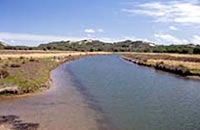
There is an extensive estuary extending 7 km from the Bald Hill Creek confluence to Andersons Inlet. At the Venus Bay Road bridge the estuary is 20 m wide with a dense riparian strip of canegrass along the water's edge then swamp paperbark. Bank fishing is possible only at cleared areas along the bank, however small light boats can be launched from the bank, and there is a concrete boat ramp at Tarwin Lower.
The most common species are sea mullet and yellow eye mullet to 800 g, small Australian salmon, black bream to 1.1 kg, luderick, occasional tailor and abundant estuary perch to 1.2 kg. The largest fish are usually taken near good stands of Swamp Paperbark.
Watkins Creek, Allambee South
Not shown on map.
A small creek forming part of the upper reaches of the Tarwin River West Branch. Flows through steep scrub-covered farmland, rock and gravel bed. Access restricted by private property. Self-sustaining trout population in the top section. Contains some brown trout average 150 g, (max. 600 g), numerous river blackfish to 500 g, congoli, common galaxias and short-finned eel.
Wild Dog Creek, Allambee South
Slower flowing water with deep pools, mud and sand substrate. Contains brown trout average 350 g, (max. 900 g), river blackfish, short-finned and long-finned eel and congoli. Access restricted by private property. Low flow in summer and may dry up completely. Last stocked with trout by Fisheries Victoria in 1969.
Wilkur Creek, Leongatha
Slow flowing creek with deep pools, mud and sand bottom. Contains Australian smelt, southern pygmy perch, and short-finned eel. Reported to also contain some brown trout average 150 g, (max. 500 g), river blackfish and congoli. Access restricted by private property. Low flow in summer and may dry up completely. Last stocked with trout by Fisheries Victoria in 1969.