Mallacoota
Mallacoota Inlet
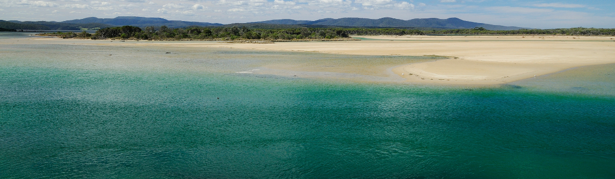
Mallacoota Inlet, located on the far eastern coast of Victoria in East Gippsland, is a fishing paradise worth the six-hour drive from Melbourne. To access the area, take the Princes Highway through Orbost to Genoa, then along the Genoa Road to Mallacoota. The large estuary adjacent to the small township of Mallacoota has an entrance to Bass Strait that opens and closes periodically. While Mallacoota is home to a significant commercial abalone fleet, it is more renowned as a secluded fishing destination best explored by boat or kayak. Nevertheless, there are ample opportunities for shore-based fishers on its western side.
Mallacoota's bream and flathead fishing inside the inlet is unmatched. Amongst the plethora of excellent estuaries in East Gippsland, Mallacoota sits atop the list in terms of fish quality and quantity. Bream, the most sought-after species in the lake, regularly weigh over a kilogram, followed by dusky flathead. Bream tournaments are conducted here every year and it's not difficult to see why. Mallacoota is famous for big dusky flathead, with fish of up to a metre on the move in the warmer months from November to April. Fifty centimetre fish are a common catch. The system holds more species, including luderick, tailor, salmon, mulloway, trevally, flounder, sand whiting, estuary perch, and mullet.
Mallacoota Inlet includes the bottom (town end) and upper lake, which are divided by the aptly named Narrows in between. The top lake stretches upstream to the Genoa and Wallagaraugh rivers and is enclosed by the majestic Croajingalong National Park. The bottom lake has an excellent boat ramp with fish cleaning tables, a wharf and ample parking. Both lakes are expansive, containing countless drop-offs, deep holes, sand and weed beds, and rocky points. However, boat operators must be aware of shifting sands and mud as it is easy to find yourself in shallow water.
Mallacoota is also home to a network of artificial reefs installed and maintained by Fisheries. Each reef consists of a number of smaller 'patch reefs' made up of 15 purpose-built reef modules of various shapes and sizes. These concrete reef modules have a rough surface and holes and cavities to allow water flow and provide refuges for marine life. They attract a wide range of popular estuary species, making them a drawcard for fishers.
The Bottom Lake
The Bottom Lake, although a vast expanse of water, can be choppy at times. Sheltered spots can still be found in manageable conditions. If you're looking to catch trevally, salmon and tailor, head towards the mouth of the lake where deeper channels are especially productive when the tide is running. Even when the entrance is closed to the sea, these species still seem to reside in this area. Around the boat ramp and wharf, you can also find luderick.
Shore-based fishers can easily access a variety of areas with dedicated fishing platforms available through to Stingray Point and beyond at Robertsons Bight via Karbethong Way. The sand flats opposite the boat ramp, as well as the shallows around Horse, Goat Islands and Rabbit Island, are excellent places to target flathead or sand whiting with lures.
For those using bait, the marked channel from Rabbit Island through to the John Bull light is a popular spot to target flathead and bream. The Fairhaven area is very popular with flathead and bream fishers willing to venture out and find a secluded area. Sometimes, estuary perch can be caught deep in these arms and large schools of mullet are encountered. From Goodwin Sands all the way to the Narrows, there are plenty of banks and drop-offs that are productive for flathead and bream, and you may even catch tailor or salmon in the open water.
Artificial reef locations can be found here.
The Narrows
The Narrows is a unique stretch of the estuary that connects the two lakes. As the name implies, it is narrow and deep, with steep sides that create a sheltered environment from most winds. While it is not a location where you will catch many fish, it is renowned for producing mammoth flathead and mulloway. To increase your chances of hooking one of these giants, you need to anchor up and fish deep. Shore-based fishers frequently target bream and flathead in the shallow margins on the west side of The Narrows using the bush tracks, and it is also popular with kayakers who launch from Karbethong.
The Top Lake
The Top Lake is famous for bream year round, but there is a defined seasonal push when vast numbers move up to spawn during winter and spring. Finding them often relies heavily on your ability to read a good sounder, particularly in the deeper stretches of either the lake itself or the rivers above. Flathead are present, with some of the biggest specimens in the Mallacoota system residing here. Usually, it is a case of quality over quantity as you move further up the lake. Shallow flats, the end of points, and the opening to backwaters are prime places for a trophy flathead. The arms on both sides of the Top Lake provide excellent opportunities to find your own patch of fish, with a little less boat traffic compared to the Bottom Lake. As you start pushing towards Gypsy Point, the shoreline becomes snaggy with more structure and backwaters that, along with flathead and bream, offer the possibility of estuary perch. However, be aware of the shallow, unmarked reef stretches in the Top Lake.
Upstream
Upstream of the Top Lake are the Genoa and Wallagaraugh arms, offering access to deep, snaggy banks inhabited by bream and estuary perch. The freshwater sections, many kilometres upstream, also hold bass. The junction of the Wallagaraugh and Genoa rivers, upstream of Gypsy Point, is an excellent spot to fish. The vast backwaters can hold anything. Shallow sand flats, mud flats, channels, weed beds, and fallen trees litter the rivers and backwaters, making for prime territory. Bream can be caught near the snags and close to the bank, where there is overhanging vegetation and access to deeper water. When the bream are stacked on the fallen timber up-river, it is some of the best bream fishing anywhere. However, navigating through this area requires careful attention due to the presence of obstacles such as fallen trees and weed beds.