Locations
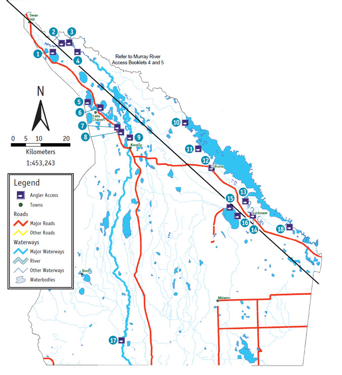
1. Lake Boga
Lake Boga: The road to, and parking at this site is good and can be accessed in a 2WD in any weather conditions. A concrete boat ramp is available which is accessable by 2WD vehicles in all weather conditions. The bank slope is flat and access to the water is moderate. The facilities available are toilets, picnic tables, fireplace/BBQ. Camping is allowed. The turn off to this site is located 44.1km north-west of Kerang along the Murray Valley Highway. Take Lake Side Drive for 2.6km to access this site.
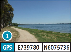
2. Letts Lane
Letts Lane: The road to this site should only be attempted in a 2WD vehicle in dry weather conditions however access and parking should only be attempted in a 4WD vehicle. The dirt boat ramp should only be attempted in a 2WD vehicle in dry weather conditions. The bank slope is steep and access to the water is moderate. Camping permitted. The turn off to is located 44.1km north-west of Kerang along the Murray Valley Highway. Take Lake Side Drive for 2.7km, Walkers Esplanade for 1.3km, Winlaton Road for 3.1km and Lette Lane for 1.6km to access this site.
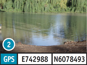
3. Pental Island Reserve
Pental Island Reserve: The road to, and parking at this site is good and can be accessed in a 2WD in any weather conditions. The dirt boat ramp can be accessed in a 2WD vehicle in all weather conditions. The bank slope is moderate and access to the water is good. Camping is allowed. The turn off site is located 40km north-west of Kerang along the Murray Valley Highway. Take the Fish Point Road for 10.6km, followed by Pental Island Road for 4km to access this site.
4. Fish Point
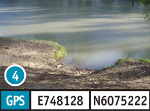
Fish Point: The road to, and parking at this site is good and can be accessed in a 2WD in any weather conditions. The dirt boat ramp can be accessed in a 2WD vehicle in any weather conditions. The bank slope is moderate and access to the water is good. Camping is allowed. The turn off is located 40km north-west of Kerang along the Murray Valley Highway. Take the Fish Point Road for 8km to access this site.
5. Kangaroo Lake
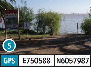
Kangaroo Lake: The road to, and parking at this site is good and can be accessed in a 2WD in any weather conditions. The concrete boat ramp can be accessed in a 2WD vehicle in any weather conditions. The bank slope is flat and access to the water is moderate. Toilets, picnic tables, fireplace/BBQ are available and camping is allowed. The turnoff is located 18km north-west of Kerang along the Murray Valley Highway. Take Racecourse Road for 1.1km, followed by Kangaroo Lake Road for 4.8km then Gorton Drive for 2km to access this site.
6. Lake Charm
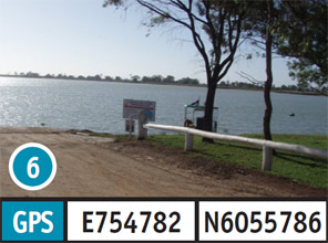
Lake Charm: The road to, and parking at this site is good and can be accessed in a 2WD in any weather conditions. The concrete boat ramp can be accessed in a 2WD vehicle in any weather conditions. The bank slope is flat and access to the water is moderate. Toilets, picnic tables, fireplace/BBQ are available. Camping is permitted. The turn off to is located 18km north-west of Kerang along the Murray Valley Highway. Take the Lake Charm east Road for 600m, followed by Park Road for 400m to access this site.
7. Middle Lake
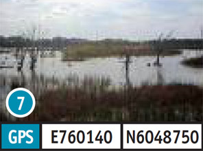
Middle Lake: The road to this site can only be accessed in a 2WD vehicle in dry weather conditions. Access and parking at this site is 2WD vehicle in any weather conditions. The bank slope is moderate access to the water is moderate. The facilities available at this site are toilets, picnic tables and fireplace/BBQ. The turn off is located 8km north-west of Kerang along the Murray Valley Highway. Take Pratt Road for 500m to access this site.
8. Reedy Lake
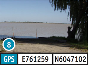
Reedy Lake: The road to, and parking at this site is good and can be accessed in a 2WD in any weather conditions. The concrete boat ramp is accessable by 2WD vehicle in any weather condition. The bank slope is flat and access to the water is moderate. Toilets, picnic tables and a fireplace/BBQ. The turn off is located 6km north-west of Kerang along the Murray Valley Highway. Take Apex Park Road for 1.1km to access this site.
9. Kerang Weir
Kerang Weir: The road to this site can be accessed in a 2WD vehicle in any condition, but access and parking should only be attempted in a 4WD vehicle. The bank slope and access to the water is moderate. The turn off is located 400m north of Kerang along the Kerang-Koondrook Road. Take the Kerang-Murrabit Road for 1.7km, followed by Lower Loddon Road for 1.8km, and then Weir Road for 300m to access this site.
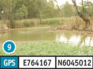
10. Koondrook End
Koondrook End: The road to, and parking at this site should only be attempted in a 2WD vehicle in dry weather conditions. The dirt boat ramp should only be attempted in a 2WD vehicle in dry weather conditions. The bank slope and access to the water is moderate. Toilets, picnic tables, BBQ/fireplace are available. Camping is permitted. The turn off to this site is located 1.1km from Kerang along the Murray Valley Highway. Take the Kerang-Koondrook Road, north-east for 22.9km, followed by Koondrook Track for 1km to access this site.
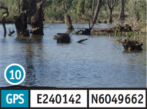
11. Spencers Bridge
Spencers Bridge: The road to, and parking at this site can be accessed in a 2WD vehicle in any weather conditions. The dirt boat ramp should only be attempted in a 4WD vehicle in dry weather conditions. The bank slope is steep and access to the water is moderate. Picnic tables, fireplace/BBQ provided. Camping is permitted. The turn off to this site is located 32.4km from Kerang along the Murray Valley Highway. Take Cohuna-Koondrook Road for 7km, follow Spencers Bridge Road for 50m to access this site.
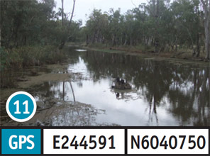
12. Cohuna
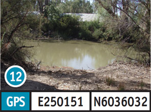
Cohuna: The road to this site is good and can be accessed in a 2WD vehicle in any weather conditions. Access and parking should only be attempted in a 2WD vehicle in dry weather conditions. The dirt boat ramp should only be attempted in a 4WD vehicle. The bank slope is steep and access to the water moderate. Picnic tables and fireplace/BBQ are available. Camping is permitted. The turn off to this site is located 33.8km south-east of Kerang along the Murray Valley Highway. Take Cohuna Island Road for 250m, followed by Tennis Road for 40m and an unnamed Road for 500m.
13. Thompsons Bridge
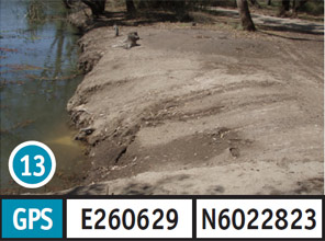
Thompsons Bridge: The road to, and parking at this site is good and can be accessed in a 2WD vehicle in all weather conditions. The dirt boat ramp should only be attempted in a 2WD vehicle in dry weather conditions. The bank slope and access to the water is moderate. Camping is permitted. The turn off is located 47.4km south-east of Kerang along the Murray Valley Highway. Take Thompsons Weir Road for 2.5km, followed by Bunyip Lane Road for 500m to access this site.
14. Gunbower boat ramp
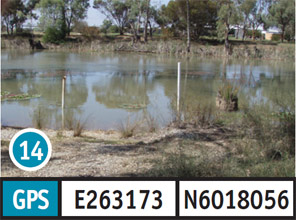
Gunbower boat ramp: The road to this site is good and can be accessed in a 2WD vehicle in any weather conditions. Access and parking should only be attempted in dry weather conditions. The concrete boat ramp available should only be attempted in a 2WD vehicle in dry weather conditions. The bank slope and access to the water is moderate. Toilets, picnic tables and fireplace/BBQ are available. The turn off to this site is located 55km south-east of Kerang along the Murray Valley Highway in Gunbower. Take Weir Street for 700m, followed by an unnamed road for 400m to access this site.
15. Box Bridge
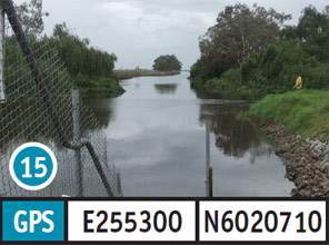
Box Bridge: The road to, and parking at this site can be accessed in a 2WD vehicle in all weather conditions. The dirt boat ramp available should only be accessed by a 4WD vehicle. The bank slope access to the water is moderate. A toilet is available and camping is permitted. The turn off is located 4.6km south-east of Kerang along the Murray Valley Highway. Take the Loddon Highway for 1km, followed by the Kerang-Leitchville Road for 33.1km, then Leitchville-Pyramid Road for 6.2km, and then Kow Swamp road for 60m to access this site.
16. Kow Swamp
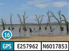
Kow Swamp: The road to, and parking at this site can be accessed in a 2WD vehicle in all weather conditions. The bank slope is flat and access to the water is moderate. The facilities available are toilets, picnic tables and fireplace/BBQ. Camping is permitted. The turn off is located 4.6km south-east of Kerang along the Murray Valley Highway. Take the Loddon Highway for 1km, followed by Kerang-Leitchville Road for 37.1km, and then Leitchville South Road for 6.2km to access this site.
17. Fernihurst Weir
Fernihurst Weir: The road to, and parking at this site can be accessed in a 2WD vehicle in all weather conditions. The dirt boat ramp can be accessed in a 2WD only in dry weather conditions. The bank slope access to the water is moderate. Camping is permitted. The turn off to this site is located 4.6km south of Kerang. Take the Loddon Highway for 64.2km, followed by Borang Prairie Road 11.8km, Loddon west Road for 1km, then an unnamed Road for 1.4km to access this site.
18. Head Works National Channel
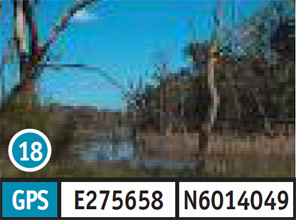
Head Works National Channel: The road to, and parking at this site is good and can be accessed in a 2WD vehicle in all weather conditions. The bank slope is steep and access to the water is moderate. Camping is permitted. The turn off to this site is located 72.2km south of Kerang along the Murray Valley Highway. Take Head Works Road for 4km to access this site.