Upper Murray
- Burrowye Creek
- Corryong Creek
- Cudgewa Creek
- Koetong Creek
- Limestone Creek
- Murray River (NSW)
- Nariel Creek
- Thowgla Creek
- Walwa Creek
![]()
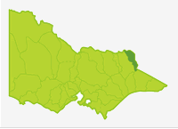
Upper Murray basin
All rivers in the north-east edge of this Basin are tributaries of the Murray River upstream of Lake Hume. The terrain consists of steep hills or mountains with forests south of Corryong and scattered forest and farmland in the north of the Basin. The upper reaches of the waterways in the forests are
in very good condition. The lower reaches of the larger rivers flow in mature valleys with broad alluvial plains. There has been loss of native riparian vegetation because of the introduction of willows, however instream habitat for biota is in good condition. Mean annual rainfall in the north is 700-800
mm but increases with altitude to over 1,400 mm in the southern mountains. All rivers had very low flows during the past drought years, however fish populations are still intact.
Only the larger more accessible rivers have been included in the Guide. The upper reaches of the Murray River are described in the section 'Murray River'.
Fishing Opportunities and Access Maps
Freshwater Fish in the Basin
Natives species
- (Large fish): Murray cod, Murray spiny crayfish and #trout cod.
- (Small fish): Australian smelt, blackfish, *climbing galaxias, flathead galaxias, mountain galaxias, southern pygmy perch
Introduced species
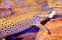
- Brown trout, rainbow trout and redfin
Native species in bold are protected in this Basin. Introduced species in bold are declared noxious.
# Trout cod were stocked into Koetong Creek and are known to have survived for several years after stocking ceased in 1991/92. Current status is uncertain. The Murray River upstream of Lake Hume is being stocked with trout cod by NSW and fish could move into rivers in this Basin.
* It is believed that the climbing galaxias entered the northern catchments via the Snowy River Scheme as they are native to the coastal catchments.
Management
See Introduction for information on management agencies and programs.
The Victorian Fisheries Authority
- manages stocking, fisheries policy, compliance with fisheries regulations and angler contact.
- Fisheries Management Plan (FMP) (a recent project that provides recreational anglers, government agencies and other stakeholders with clear guidance on fisheries management issues with a regional area over a five year period).
A FMP has been declared for waters within this Basin. Fisheries Victoria Report Series. North East Fishery Management Plan. No 48. August 2007. - Stocking Program (stocking plans for desirable species are based on an approved Victorian Fisheries Authority stocking policy and are reviewed annually via Vic Fish Stock). Cudgewa Creek receives irregular stockings of Murray cod. All other rivers carry self-sustaining populations of fish. See
details in the Angling Waters.
Up-to-date information on numbers and size of each species stocked can be found under Fish Stocking in the Fisheries and Aquaculture section of this website or in the annual Vic Fish Stock Report published by the department. - Family Fishing Lakes Program (an ongoing project of stocking small waters within urban areas with larger trout, for junior and disabled anglers, see Introduction). None in this Basin.
- Victorian Stream Classification (a project that was completed in November 2010, which classifies each water as a native, salmonid or mixed fishery). Classifications relevant to this basin are:
- Trout - Corryong and Cudgewa creeks upstream of Briggs Gap Road. All other Murray River tributaries upstream of the Murray Valley Highway including the Nariel Creek.
- Mixed - all waters downstream of the Murray Valley Highway not mentioned elsewhere. Corryong Creek and Cudgewa Creek downstream of Briggs Gap Road. Sandy, Flaggy and Jarvis creeks.
North East Catchment Management Authority
- is responsible for catchment management and the Victorian River Health Program.
- Victorian River Health Program (an ongoing state government initiative to achieve healthy rivers, streams and floodplains). Work is continuing in Nariel, Koetong and Thowgla creeks.
Goulburn Murray Rural Water
- manages irrigation, domestic and stock and some bulk water supplies and development of Stream Flow Management Plans.
- Stream Flow Management Plans (an ongoing project in which various agencies and water users develop a flow sharing arrangement which ensures an adequate environmental flow allocation for each river in Victoria). No stream flow management plans have yet been developed for waters in this Basin.
North East Water
- manages urban demand.
Best Fishing Waters
| Water | Species |
|---|---|
Cudgewa Creek | Brown trout |
Nariel Creek | Brown trout |
Special Values
Natural Catchment Areas
Log Bridge Creek has been listed as a Natural Catchment Area.
Threatened Fish Species
Three species in this Basin (Murray cod, trout cod and Murray spiny crayfish) are threatened species in Victoria (Department of Sustainability and Environment [DSE] Dec 2007). The list of Victorian threatened species, with their national conservation value, scientific names and explanation of their conservation status category, is available on the DSE web site.
Species in bold type are also listed under the Flora and Fauna Guarantee Act (1988) and cannot be taken or kept without an order, licence or permit. Such an order by the Governor in Council allows anglers to take Murray cod and Murray spiny crayfish.