South Gippsland (East) - Angling Waters
View South Gippsland (East) Basin in a larger map (opens new window).
The above map is provided by Google. The department accepts no responsibility for its accuracy or content.
Agnes River, Welshpool
Small picnic ground and scenic reserve at the Agnes Falls.
The river can be separated into three sections. The upper reaches above the falls flows through timbered then cleared hills. There are riffles, fast water and a rock and gravel substrate. The river then flows through a 4 km long gorge alongside the Agnes River Road. Channel width has increased to 10 m with extensive areas of water 50-70 cm deep. It has good riparian vegetation, boulder substrate, extensive riffles and excellent fish habitat.
The lower reaches are deeper (100+ cm) and narrower (3-6 m) with a mud and gravel substrate. It has slow-flowing water in the pools, some excellent habitat and abundant aquatic vegetation. In some sections, there are riparian willows. Angling species are short-finned eels, which are widespread, and brown trout (av. 120 g, max. 400 g) which are most abundant in the upper reaches near Dingo Creek junction. Access to the best trout areas is difficult. Other fish present are mainly small-sized species; climbing galaxias, trout galaxias, congoli, occasionally Australian grayling, common galaxias, Australian smelt, pouch lamprey, striped gudgeon and Cox's gudgeon.
The estuary is difficult to reach because of private property. It contains mostly yellow eye mullet, flounder and some estuary perch and Australian bass.
Albert River, Yarram
Above Staceys Bridge
A fast-flowing stream originating as a number of small tributaries in steep forest but running for most of its length in moderately sloping farmland. Width varies from 4-6 m upstream to 8-10 m downstream. Substrate is rock and rubble with extensive shallow riffles (20 cm deep) and good pools (over 100 cm). Riparian vegetation varies from scattered eucalypts, wattles, to a few willows and open pasture. The river is very accessible from the Albert River Road. Predominant angling species in this section are brown trout to 350 g, abundant small river blackfish, short-finned and long-finned eels.
Below Staceys Bridge
The river is now 8-10 m wide, with steep banks and flows through flat, open farmland. The water is deeper and is usually turbid, mud and sand bottom. Riparian vegetation is willows and pasture. Flow can be low in summer.
Eels (short-finned and long-finned) are the predominant species. Other fish present in various areas of the river are climbing galaxias, trout galaxias, congoli, Australian grayling, common galaxias, Australian smelt, southern pygmy perch, bridled goby and flathead gudgeon.
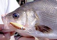
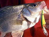
The estuary (which extends upstream of the South Gippsland Highway) is popular with anglers and contains flounder, yellow eye mullet, sea mullet, luderick, Australian salmon, black bream and good numbers of Australian bass and estuary perch.
Bruthen Creek, Carrajung South
Above the Hyland Highway
A small, fast-flowing creek (2-3 m wide) with predominantly shallow riffles but some larger pools over 100 cm deep. Substrate is rubble in the riffles and mud in the pools. Flows through farmland and on the edge of forest and pine plantations upstream. Riparian vegetation is scattered willows and wattles. Access in the middle reaches, is restricted by private property and the distance of the river from the road. (Lower reaches best reached from Saddle Road).
May carry a few brown trout but mostly short-finned eel, climbing galaxias and common galaxias. Other fish are Australian smelt, shorthead lamprey, eastern dwarf galaxias, southern pygmy perch and flathead gudgeon.
Below the Highway
The creek is 2-3 m wide with mud substrate and shallow pools (80 cm deep). Flows through flat farmland with light riparian vegetation. Accessible only from a few crossroads. May be worth fishing immediately downstream of the highway but contains few angling fish in the lower reaches.
Clear Creek, Mirboo
Flows through cleared, hill country as a series of runs and pools, rock and gravel bed. Contains brown trout (av. 150 g) and short-finned eels.
Darby River, Tidal River
A short stream flowing from inaccessible scrub country in the Wilsons Promontory National Park. Fishing is permitted below the Tidal River Road but no fishing is allowed upstream. Fish in the freshwater are climbing galaxias, trout galaxias, congoli, common galaxias, short-finned and long-finned eel, striped gudgeon, flathead gudgeon, numerous pouch lamprey and abundant southern pygmy perch, There is no estuarine section as the river flows down a steep slope to the sea over a rubble substrate. Some estuarine species may enter the river mouth at high tides. Fishing for estuary species not recommended.
Deep Creek, Foster
Tributary of the Franklin River. This is a fast-flowing stream in steep cleared farmland but has good bank vegetation of tree ferns and native trees. Width varies from 2 m upstream to 5 m downstream. Substrate is rock, then mud and gravel in the lower reaches. Shallow water upstream (pools 50 cm, riffles 5-10 cm). The lower reaches have been highly modified by agriculture but there is some deeper water, instream woody habitat and fish habitat. Access is difficult and by walking only. There is a population of trout in the headwaters, and congoli and possibly short-finned and long-finned eel downstream.
Dingo Creek, Welshpool
Not shown on map.
This small tributary of the Agnes River flows through timbered hills and has a rock and gravel substrate. Summer flow is low with considerable shallow water. Contains a large population of small-sized brown trout (av. 20 g, max. 300 g). River blackfish, short-finned and long-finned eel are reported to be present. Access is difficult because of the terrain.
Franklin River, Foster
There is a large, family picnic area at the South Gippsland Highway crossing.
A fast-flowing stream rising in forested-hills upstream of the Foster-Mt Best Road, rock bottom. Access upstream is difficult and walking is required to reach most of the river. The only brown trout fishing is in the headwaters. The middle reaches flow through a narrow valley in steep farmland alongside the Franklin River Road. Riparian vegetation is dense willows and wattles.
The river is 5 m wide with deep pools (over 100 cm) and narrower shallow riffles with rock and rubble substrate. Freshwater fish include brown trout upstream of the Foster/Mt Best Road, climbing galaxias, congoli, Australian grayling, common galaxias, long-finned eel, Australian smelt, short-finned eel and the occasional river blackfish.
Downstream of the South Gippsland Highway the river flows through flat farmland, channel width is 3-4 m, with predominantly shallow riffles (less than 50 cm) and occasional pools.
Sand and mud substrate. Riparian vegetation consists of willows. Contains abundant short-finned and long-finned eels in the lower reaches but few other angling species. The estuary contains good numbers of estuary perch and some Australian bass, particularly around the bridge on the Port Franklin/Toora Road.
Greigs Creek, Calrossie
Not shown on map.
This tributary of the Tarra River flows through lightly forested hills. It is fast flowing with a gravel and rock substrate. Access is difficult because of the terrain and the lack of road access. It contains abundant river blackfish and some brown trout. Other fish are climbing galaxias, congoli, common galaxias, Australian smelt and short-finned eel.
Jack River, Yarram
This is a tributary of the Albert River. It rises in lightly forested hills and extensive pine plantations as a fast-flowing stream with a rock bottom but then flows mostly through cleared farmland. The middle reaches are up to 4 m in width with good water depths in the riffles (50 cm) and pools to 100 cm deep. Substrate is hard clay. The lower reaches are wider with deeper pools to 120 cm. There is algal growth over the substrate and instream encroachment of willows and cumbungi. Contains brown trout (av. 160 g, max. 520 g) in the upper reaches, climbing galaxias, short-finned and long-finned eels.
Little Albert River, Staceys Bridge
This small tributary of the Albert River (2-4 m wide) is a fast-flowing creek in steep forested hills, rock and rubble bottom. Contains abundant small brown trout to 350 g, climbing galaxias and mountain galaxias. Short-finned and long-finned eels and river blackfish (present in Albert River) may also occur.
Macks Creek, Calrossie
There is a picnic area with facilities at the Visitor Centre but no overnight accommodation.
This other major tributary of the Tarra River rises in the Tarra-Bulga National Park (accessible from either Yarram or Traralgon). Most of the creek is remote and access is difficult. It flows in forested hills and has a rock and gravel bottom. Brown trout (av. 300 g, max.900 g) are the main angling species. Other fish are abundant climbing galaxias, congoli, common galaxias, numerous small river blackfish, short-finned and long-finned eel.
Merriman Creek, Gormandale
Upstream of a rock barrier, 1.2 km above Giffard Road Bridge.
The freshwater section is a narrow (2 m) shallow creek, with only a few deeper sections and sand substrate. Fish include brown trout upstream of Gormandale (good numbers near the junction of Morrison Creek), common galaxias, Australian smelt, southern pygmy perch, short-finned and long-finned eel, flathead gudgeon, pouch lamprey and shorthead lamprey. Australian grayling were taken in surveys prior to 1981 and probably still occur. Main angling species around the South Gippsland Highway are short-finned and long-finned eel and congoli. Flow can be low in summer.
Downstream of the Rock Barrier (consists of 10 km of usually fresh water then 2.5 km of estuary).
The freshwater river at Giffard Bridge has riffles only 2-3 m wide and 10-30 cm deep with scattered pools up to 15 m in width but only 40-100 cm deep, during summer flows. Substrate is shifting sand and the habitat is satisfactory only for small-sized fish. The upper reaches of the estuary are up to 20 m wide with riffles to 60 cm deep and pools to 110 cm. The lower reaches of the estuary are severely silted, with most water less than 2 m deep. The most common fish in the estuary are yellow eye mullet, flounder, luderick, Australian salmon and black bream. Estuary perch and Australian bass can be taken upstream to the rock barrier when the mouth of the estuary is open and water level is high. The estuary has become shallow because of sedimentation and is not considered to be a prime fishing water.
Reedy Creek, Carrajung South
This upper tributary of the Bruthen River is 2 m in width, with fast-flowing water and a gravel bed. It has some good pools but access is difficult because of the terrain and private property. Contains mostly brown trout (av. 200 g, max. 450 g,) some rainbow trout of a similar size and short-finned and long-finned eel.
Tarra River, Yarram
Upstream from Calrossie
Rises in remnant native forest in the Eastern Strzelecki Ranges (Tarra-Bulga National Park) and then flows through partly cleared hilly farmland. In the headwaters the river is shallow and fast flowing with good habitat for small trout. There is a good picnic area with facilities and a range of overnight accommodation options is also available. The Tarra Valley Road runs up the river for most of its length. Access to the headwaters however, is difficult because of the terrain.
The river is very accessible further downstream. It is now up to 8 m wide but is predominantly shallow riffles with some small pools to 100 cm. Substrate is boulder and rubble, with patches of sand downstream. This section carries some small brown trout but the river is predominantly shallow riffles with limited instream fish cover. Other species present in the river are climbing galaxias, mountain galaxias, trout galaxias, Australian smelt, river blackfish, southern pygmy perch, short-finned and long-finned eel, flathead gudgeon, congoli and Cox's gudgeon.
The last six species are probably more common in the middle and lower reaches.
Downstream of Calrossie
The river flows in flat farmland and becomes deeper, with steep banks and often dense willow riparian vegetation. The river is up to 8 m wide near the South Gippsland Highway with pools to 200 cm, riffles 20-30 cm and patches of rubble on mud. Willows have encroached into the channel. Willows are being removed and replaced with native vegetation as part of the River Health Program. The section downstream to the start of the estuary varies from 2-6 m in width with pools 120-200 cm deep. There is often dense riparian and instream aquatic vegetation. Substrate is mud. Good habitat for small native fish but fishing opportunities are poor. Main angling species are congoli, short-finned and long-finned eel, as well as some of the species mentioned in the upper section.
The estuary extends at least 2 km upstream of the bridge at Tarraville and has sections with dense riparian vegetation. Access is good and it is a popular fishing area. The Catchment Management Authority has undertaken to fence the entire length of this river and the majority of its tributaries. This also involves removal of willows and revegetating with native species. Fishing platforms and access tracks have also been constructed in the lower reaches. The most common fish are abundant estuary perch, yellow eye mullet, flounder, luderick, Australian salmon, black bream and some Australian bass.
Tarwin River, East Branch Tarwin
This is the extreme upper reaches of the river, upstream from Mirboo. The remainder of the east branch downstream from Mirboo is described in South Gippsland (West) Basin.
This is a small waterway and flows through cleared hilly country as a series of runs and pools, rock and gravel bed. Fish are abundant small brown trout (av. 150 g), climbing galaxias, congoli, common galaxias, Australian smelt, short-finned eel and river blackfish.
Tidal River, Tidal River
A rock-ramp fishway has been constructed at the storage.
Flows from forested hills in the centre of Wilsons Promontory National Park. Closed to fishing upstream of the Tidal River Road but contains congoli, common galaxias, short-finned eel, pouch lamprey and flathead gudgeon. The lower estuary reaches are open to fishing with the most common species being abundant estuary perch, yellow eye mullet, flounder, luderick, Australian salmon and black bream. Good quality habitat. There is a boardwalk around the edge of the estuary with fishing spots. Small boats can be launched from the beach adjacent to the estuary in calm sea conditions.
Turtons Creek, Foster
This is a small upper tributary of the East Tarwin River. It flows through cleared hilly country as a series of cascades, runs and pools, rock and gravel bed. Some native riparian vegetation. There is an area of grassy flats (where a picnic can be held) at the Turton Creek Scenic Reserve. Fish are abundant small brown trout (av. 150 g), climbing galaxias, short-finned eel and river blackfish.
Wilsons Promontory Streams
Check with the department at Yarram regarding fishing in waters other than the Darby and Tidal River estuaries as angling in other estuaries may be restricted. Access to all freshwater streams is by walking. Most freshwater fish are small-sized and larger species are not sufficiently abundant to recommend the area for fishing. Freshwater fish are eastern dwarf galaxias, common galaxias, trout galaxias, climbing galaxias, river blackfish, congoli, short-finned eel, shorthead lamprey, pouch lamprey, flathead gudgeon, long-finned eel, striped gudgeon, southern pygmy perch and estuary perch.