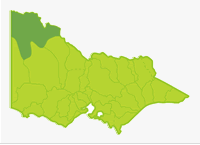
Mallee
- Cardross Lake
- Cullulleraine Lake
- Hattah Lakes
- Hawthorn Lake
- Kings Billabong
- Lindsay River
- Murray River (NSW)
- Walla Walla Lake
- Wallpolla Creek
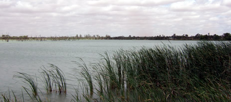
The Basin is located in a semi-arid zone and the landscape is characterised by low ridges, dunes and lumpy terrain. The Murray River floodplain, anabranches and associated wetland systems dominate the northern part of the region and provide all of the angling in this Basin. The swamps and lakes are of varying salinity and almost all are filled by overflow of the Murray River. There is a lack of perennial streams apart from several anabranches of the Murray River.
Mean annual rainfall is 600 mm in the south decreasing north to 270 mm at Mildura. Vegetation varies from widespread mallee to extensive grassy-plains, sand-plains and salt pans in the northern Sunset Country. The Big Desert in the south is infertile sand, covered with scrub. Groundwater in the south is fresh to marginal but is saline (>8,000 EC) in the north.
Fishing Opportunities and Access Maps
Freshwater Fish in the Basin
Native species
- (Large fish): Murray cod, golden perch, bony bream, Murray spiny crayfish, #silver perch, freshwater catfish.
- (Small fish): Mountain galaxias, southern purplespotted gudgeon, Murray hardyhead, Murray River rainbow fish, southern pygmy perch, flathead galaxias, flathead gudgeon, unspecked hardyhead and Australian smelt.
Introduced species
- Redfin, European carp, tench, goldfish and eastern gambusia.
Native species in bold are protected in this Basin. Introduced species in bold are declared noxious.
#Silver perch can only be taken from lakes or impoundments.
Most surveys used fishing gear designed to catch larger fish. The small species are probably much more common and widespread than shown in the description of individual waters.
Management
See Introduction for information on management agencies and programs.
Victorian Fisheries Authority
- manages stocking, fisheries policy, compliance with fisheries regulations and angler contact.
- Fisheries Management Plan (FMP) (a recent project that provides recreational anglers, government agencies and other stakeholders with clear guidance on fisheries management issues with a regional area over a five year period).
Victorian Fisheries Authority will develop a FMP for waters with this Basin in the future. - Stocking Program (stocking plans for desirable species are based on an approved Victorian Fisheries Authority stocking policy and is reviewed annually via Vic Fish Stock). Only Lake Cullulleraine is stocked with golden perch and Murray cod.
Up to date information on numbers and size of each species stocked can be found under Fish Stocking in the Fisheries and Aquaculture section of this website or in the annual Vic Fish Stock Report published by the department. - Family Fishing Lakes Program (an ongoing project of stocking small waters within urban areas with larger trout, for junior and disabled anglers, see Introduction). None in this Basin.
- Victorian Stream Classification (a project that was completed in November 2010, which classifies each water as a native, salmonid or mixed fishery). Classifications relevant to this basin are:
- Native - all waters.
Mallee Catchment Management Authority
- is responsible for catchment management and the River Health Program.
- Victorian River Health Program (An on-going State Government initiative to achieve healthy rivers, streams and floodplains). Special environmental flood flows for red gum forests were provided in 2003-05 for Lindsay and Walpolla Islands and Hattah Lakes.
Grampians Wimmera Mallee Water
- manage irrigation, urban, domestic and stock water services, also development of Stream Flow Management Plans in the southern section of this Basin (south of and including Ouyen).
- Stream Flow Management Plans (an ongoing project in which various agencies and water user's develop a flow sharing arrangement which ensures an adequate environmental flow allocation). None developed.
Lower Murray Water
- manages irrigation, rural and urban diversions and services along the Murray River, including Mildura
Best Fishing Waters
| Water | Species |
|---|---|
| Cullulleraine Lake | Golden perch, Murray cod |
| Lindsay River | Golden perch, Murray cod |
| Walpolla Creek | Golden perch, Murray cod |
Other Values
Ramsar Sites
(wetlands of international significance, Convention on Wetlands. Ramsar. Iran 1971)
Lakes Bitterang, Cantala, Konardin, Yelwell, Yerang, Mournpall, Bulla, Hattah, Arawak, Brockie and Kramen in the Hattah-Kulkyne National Park are listed as Ramsar Sites.
Threatened Species
Eight species in this Basin (Murray cod, freshwater catfish, Murray hardyhead, Murray River rainbowfish, silver perch, unspecked hardyhead, southern purplespotted gudgeon and Murray spiny crayfish) are threatened species in Victoria. The list of Victorian threatened species, with their national conservation value, scientific names and explanation of their conservation status category, is available on the DSE web site (Department of Sustainability and Environment [DSE] Dec 2007).
Species in bold type and the Lowland Riverine Fish Community of the Southern Murray Darling Basin are also listed under the Flora and Fauna Guarantee Act 1988. ) and cannot be taken or kept without an order, licence or permit. Such an order by the Governor in Council allows anglers to take Murray cod and Murray spiny crayfish from any water and silver perch only from lakes or impoundments in this Basin.