Loddon (North) - Angling Waters
View Loddon River (North) Basin in a larger map (opens new window).
The above map is provided by Google. The department accepts no responsibility for its accuracy or content.
Bannacher Creek, Durham Ox
Flows through cleared farmland with little riparian vegetation apart from lignin bushes. The channel is a shallow depression 10 m wide and less than 100 cm deep. It usually dries up each year. Reported to carry European carp, goldfish and redfin in a few pools but seldom fished and not recommended.
Barr Creek, Cohuna
A shallow 3 m wide channel flowing into the upper Loddon River. Suffers from stratification, low concentration of dissolved oxygen and high salinities (up to 35,000 EC) along its entire length. Carries European carp. Not recommended for angling.
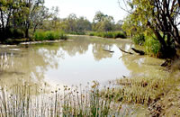
Big Lake, Meran
See Meering Lake
Boga Lake, Lake Boga
906 ha. 36,700 ML. Boat ramp, picnic area, caravan park and all facilities.
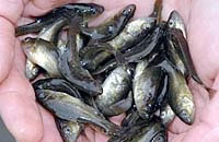
A sand-bottom lake situated adjacent to the Lake Boga township and surrounded by farmland. It forms part of the local irrigation system providing water to orchards, pasture and vineyards in the Kerang-Swan Hill area. Dry in 2008 but when operational it will become an online storage subject to extreme fluctuations in water level. There are separate areas in the lake for boating and fishing. When full it contained mostly redfin to 2 kg, European carp to 3.4 kg, goldfish, bony bream, occasional golden perch, Murray cod, silver perch and Australian smelt. Excellent access but aquatic vegetation around the edge makes a boat necessary for successful fishing. Stocking of chemically marked golden perch and dart tagged Murray cod commenced in 2004 following the buy-back of inland commercial fishing licences and the recovery of the lake's water level.
Boort Lake, Boort
455 ha. 9,600 ML.
A very shallow, weedy lake with abundant standing dead timber adjacent to Little Boort Lake. Surrounded by farmland and mud bottom. Dry since 2002 and will not fill again except after very high floods. When full it contained redfin and European carp. Not recommended for fishing because of dense submerged aquatic vegetation.
Box Creek, Leitchville
Drains Kow Swamp and flows through farmland. Channel is up to 10 m wide with riparian vegetation of cumbungi and scattered trees. Accessible at the Kow Swamp outlet. The first 3 kilometres are a popular fishing area for redfin and golden perch, which enter the creek from Kow Swamp. Not stocked.
Brandy Lake, Kerang
See Wandella Lake
Bullock Creek, Mitiamo
A small weedy creek with irregular flow and not recommended for angling.
Charm Lake, Kerang
457 ha. 19,940 ML. Caravan park, boat ramp. Ramsar listed.
A semi-permanent slightly saline lake surrounded by farmland, sand bottom. Part of the irrigation system supplying water for agriculture in the Kerang-Swan Hill area. Contains a very good population of redfin, which is the main angling species. Also European carp, golden perch, Murray cod, abundant bony bream, goldfish, Australian smelt and flathead gudgeon. Boat needed for successful fishing.
Cullens Lake, Kerang
615 ha. 15,000 ML Permanent saline, Ramsar listed.
Surrounded by open land and has a sand and mud bed. Dry most of the time. When full could possibly contain European carp. Small native fish such as Australian smelt, unspecked hardyhead, flathead galaxias and Murray hardyhead used to be present when the lake was full and less saline. Seldom fished.
Elizabeth Lake, Kerang
80 ha. 1,500 ML. Saline. Caravan park.
A shallow weedy lake surrounded by farmland, sand bottom. Murray hardyhead had been recorded but the water is now saline and contains no fish.
Boating is prohibited.
Gunbower Creek, Cohuna
Camping possible in the red gum forest, no facilities. Ramsar listed.
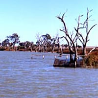
A 60 km long anabranch of the Murray River, flowing from south of Gunbower to Koondrook. It forms the south western boundary of Gunbower Island. This is the largest (20,000 ha) permanent island of this type in the Southern Hemisphere. It has a red gum forest with native birds and animals and is a popular tourist area.
Flow in the creek is controlled by irrigation releases with lowest flows during the non-irrigation period (15 May-15 August).
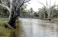
Gunbower Creek flows from the Murray River to Cohuna, through open farmland. The channel is 25-35 m wide with sand substrate. Riparian vegetation is cumbungi and red gums and there is abundant dead timber along the banks. Small boats can be launched from the bank and the river is very accessible. Water depth increases to 150-200 cm during high flows.
The river becomes narrower (16-20 m) when it flows for a further 20 km through the red gum/black box forests north of Cohuna; before re-entering the Murray River at Koondrook.
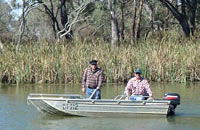
Banks are 1 m high and there is good access for bank fishing and boat launching at Spence Bridge via Tresize Road, 7 km from Cohuna. Water depth at low flow is around 150-200 cm and there is good instream snags and fish habitat. Riparian vegetation is cumbungi, reeds, occasional wattles, and eucalypts.
Contains abundant European carp, golden perch, numerous Murray cod, silver perch, redfin, tench, goldfish, Australian smelt, Murray River rainbowfish, eastern gambusia and freshwater catfish in the lagoons. An excellent angling water. Stocked annually with Murray cod. Freshwater catfish and silver perch are protected and must be returned alive.
In recent years the North Central CMA has provided increased flood events (environmental flooding) at the northern end of Gunbower Island, to enhance the ecological health of the forest. The objective is to reinstate wetlands back to 50% of their original area. Results are being monitored and there are already improvements in bird breeding and 600 records of five frog species being present.
Hird Swamp, Cohuna
400 ha. Deep freshwater marsh. Ramsar listed.
Dries out periodically and dry in 2008/09. Contains European carp when full. Not recommended for angling.
Johnson Swamp, Kerang
485 ha Deep freshwater marsh. Ramsar listed.
Dry in 2008/09. When full may carry some European carp. Not recommended for angling.
Kangaroo Lake, Kerang
980 ha. 34,390 ML. Deep freshwater marsh. Ramsar listed. Boat ramps and caravan parks on northern and western shores, popular camping and picnicking area.
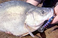
A deep lake with a mud and sand bottom, surrounded by farmland and citrus groves. Part of the irrigation system supplying water for agriculture in the Kerang-Swan Hill area. Contains redfin, bony bream, golden perch, European carp, Murray cod, a few silver perch and possibly freshwater catfish. Also Australian smelt, flathead gudgeon and goldfish. Good bank fishing is available. Quality redfin can be taken on baits (yabbies, worms and shrimp). One of the best fishing waters in the Basin. Freshwater catfish are protected and must be returned alive if caught.
Kow Swamp, Gunbower
2,720 ha. 51,700 ML. Also called Mount Hope Swamp. Part of the Torrumbary irrigation scheme.
Surrounded by open country with abundant dead timber and cumbungi around the shoreline. Shallow water, aquatic vegetation and snags. Requires careful boating. Contains redfin, European carp, silver perch, golden perch, bony bream, freshwater catfish, Murray cod, goldfish, Australian smelt, Murray River rainbowfish, and eastern gambusia. Difficult to fish because of aquatic vegetation. Contains a self-sustaining population of Murray cod. Freshwater catfish are protected and must be returned alive if caught.
Leaghur Lake, Boort
50 ha. 1,100 ML.
No boat ramp, and seldom fished because of abundant submerged aquatic vegetation. Contains redfin, tench and European carp. Not recommended for angling. Presently (2008/09) dry and unlikely to fill except in wet years.
Little Boort Lake, Boort
93 ha. 1,700 ML. Boat ramp, caravan park, walking track around the lake, water sports and skiing.
A small, tree-lined lake adjacent to the township of Boort. The lake is zoned for power, sail and self-propelled boats. Boating activities can restrict angling opportunities at times. Located on the edge of town. Carries golden perch, bony bream, European carp, redfin, goldfish, tench, and flathead gudgeon. Stocked regularly with golden perch but no stocking in 2009 unless conditions improve.
Little Lake Meran, Kerang
30 ha. Also called Little Lake Meering.
A deep lake, mud bottom and weedy edges. Surrounded by farmland. Used to carry European carp, redfin, tench, goldfish and some Murray cod. Stocked with Murray cod up until 1998. Fish can become infested with red worms (Eustrongyloides) which are harmless to humans. A boat is needed for fishing because of the weed. Drought affected since 1999 and still not full in 2008/09. Will be stocked with Murray cod when conditions are again suitable, but unlikely to occur because of possible changes to water allocations for the lake.
Little Murray River, Swan Hill
This is a 30 km long anabranch of the Murray River which has a weir at each end (Fish Point Weir at the mouth of the Loddon River and Little Murray Weir upstream). Flow in the Little Murray River comes from the Murray River during the non-irrigation period or from the Loddon River direct or the Avoca River via a channel, depending on irrigation requirements. During high flow irrigation periods, water depth averages 200 cm with pools up to 7 m deep.
During the non-irrigation period (15 May-15 August) water depth between the pools can drop to less than 1 m, if natural flow in the Murray River is also low. High salinity in the pools and very low concentrations of dissolved oxygen (less than 5% saturation) can also occur during low flows.
River width is 40-50 m and riparian vegetation is red gums, canegrass and saltbush. Good instream snags.. Turbid water and sluggish flow, during the non-irrigation period. Access is restricted by the scarcity of roads. However there is good access at Fish Point Road with bank fishing and boat launching possible from the bank. Contains abundant golden perch, some freshwater catfish, silver perch, Murray cod, European carp, redfin, bony bream, tench and goldfish.
Most common angling species are golden perch, European carp and redfin. Murray cod are present but are not easy to catch. Stocked annually with Murray cod.
Loddon River, Kerang
The section of river upstream of Serpentine has been described in Basin 7 south
The river between Serpentine township and the Murray River can be divided into several distinct sections. The first consists of a 15 km stretch of river from the Serpentine Weir (a small concrete structure near the township of Serpentine to Loddon Weir (also called Fernihurst Weir). This section has high summer flows as water is passed downstream to Loddon Weir and then diverted into the Waranga Western Channel.
The next 60 km section of river downstream to Macorna Channel, receives no extra summer flow and has considerable periods of low flow and low water level. Water via the Macorna Channel enters the Loddon River about 10 km south of Kerang. This provides a high flow in the next 15 km of river downstream of Macorna Channel to the Kerang Weir at Kerang. The river then flows for a further 35 km to the Little Murray River.
The entire length of river in this Basin is less than 2 m deep with good mixing of water in the pools and no development of anaerobic saline water on the bottom during summer. However water salinity of the river does increases from around 600 EC at Serpentine to 1,600 EC at Kerang. At times of low flow in the river, the concentration of dissolved oxygen in the deeper water in Loddon Weir can fall to 20-40% saturation.
Serpentine Weir to Loddon Weir (also called Fernihurst Weir)
The best fishing area in this section of river between Serpentine and Loddon Weir is in the backwaters of Loddon Weir. Note that Murray cod and golden perch are stocked from Newbridge to Kerang.
Loddon Weir
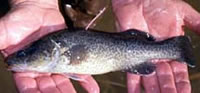
There is access by road to the weir where a boat can be launched off the bank. Walking access around the weir is restricted by private property. There is an extensive (11 km) stretch of water (up to 5-7 m deep) upstream of the wall of the Weir, which provides excellent fishing for redfin to 1.3 kg, golden perch to 1 kg, European carp to 2 kg and the occasional Murray cod to 15 kg. There are also silver perch to 500 g which are protected in rivers and must be returned alive if caught.
Trolling with lures or bait fishing (see Murray River section) are popular fishing methods. The water level in the Weir is lowest in winter and early spring when there are no releases of water for irrigation, from upstream. Best fishing is when irrigation water releases from upstream enter the Weir in early September and then until water releases stop in early May. Fishing in the morning and evenings gives best results. Worms, yabbies and shrimps are good baits for redfin. Stocked with golden perch and Murray cod at Fernihurst.
Downstream of Loddon Weir to the inflow from Marcorna Channel
This 60 km section of river is mostly 7-14 m in width with occasional wider areas to 26 m. It is predominantly shallow water 50-70 cm deep with no pools deeper than 150 cm. Substrate is soft mud. Flow is low during summer and controlled by release of water from Loddon Weir. Although the river flows through flat farmland there is a light growth of eucalypts along the banks. There is good access from a number of crossroads. Bank height is around 3 m with areas of exposed mud along the bottom of the banks.
There are some snags on the riverbed. Predominant species are redfin, European carp, silver perch, and golden perch to 2kg. The natural population of Murray cod appears to have died out by the 1950's and Murray cod are now being stocked as well as golden perch. Other species present are goldfish, eastern gambusia, Australian smelt, flathead gudgeon, and possibly bony bream and Murray River rainbow fish. A light line and lures or a running sinker with bait is suitable for redfin, and golden perch. Silver perch are protected and must be returned alive to the water if caught.
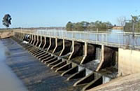
Downstream of Marcorna Channel to the Kerang Weir
A vertical slot fishway has been constructed on the Kerang Weir.
Fresh water enters the river from the Marcorna Channel increasing flow and water depths for the next 10 km to Kerang. Average depth is now 140 cm with pools to 200 cm deep. The banks are lower (2-3 m) and riparian vegetation is scattered red gums. Channel width varies from 10-24 m. The river flows through flat farmland and the substrate is soft mud. There is little channel configuration (pools/riffles) and only a small amount of snags. Species found in the previous section also occur in this reach of river. A boat can be launched from the bank and used on the river. Stocked with golden perch and Murray cod at Kerang.
Each year, golden perch moving upstream from the Murray River to spawn, were blocked at the Kerang Weir wall. The new fishway opens up another 70 km of the Loddon River, upstream of Kerang.
Kerang to Murray River
Flows through saltbush and black box forest. Average water depth is 100 cm with occasional deeper pools. Access is reasonable but this section is not heavily fished. Main angling species are redfin, golden perch and Murray cod.
Long Lake, Swan Hill
125 ha. 9,225 ML.
A drainage swamp surrounded by vineyards. Used to carry redfin, tench, European carp, eastern gambusia and Murray hardyhead but is now saline. Not recommended for angling.
Marraboor River
Meering or Meran Lake, Kerang
203 ha. 6,150 ML. Camping facilities, boat ramp and water skiing.
Surrounded by agricultural land, sand bottom. The lake is zoned with areas for speed boating and fishing. Carries mostly redfin and there are reports of occasional Murray cod. Also possibly European carp, bony bream, goldfish and flathead gudgeon. Has a sandy shoreline and is a popular recreational area. Stocked irregularly with golden perch. Dry in 2008/09. To be stocked with golden perch when conditions are suitable. However this lake will be part of an irrigation system and may not fill again, except from rainfall events.
Mount Hope Creek, Mitiamo
Also called Piccaninny Creek.
A 2 m wide drain with spasmodic flow. Has brackish water at times (7,600 EC). Contains European carp. Not recommended for angling.
Murray River (NSW)
See Murray River
Murphy Lake, Kerang
227 ha. 3,500 ML. Saline.
Surrounded by agricultural land. Dries up at times and not recommended for angling. Contains European carp.
Murrabit River
See Barr Creek
Pelican Lake, Kerang
40 ha. 580 ML. Very saline.
Surrounded by farmland, mud bottom. No recent record of fish being present.
Picaninny Creek
See Mt Hope Creek
Pyramid Creek, Kerang
A 15 m wide stream flowing through saltbush and farmland. Riparian vegetation consists of lignin, cumbungi, reeds and very occasional black box trees. Water depth is about 200 cm. Steep banks and mud bottom. Carries mostly redfin, European carp, numerous silver perch, abundant golden perch and a few Murray cod. Best fishing in the lower reaches near Kerang or near the outfall of Kow Swamp where it is known as Box Creek. Can have a low flow during the non-irrigation period (15 May-15 August). Stocked annually with Murray cod and golden perch. Fish from the Murray River and the Lower Loddon River can now enter this creek through the fishway at the Kerang Weir.
Racecourse Lake, Kerang
241 ha. 5300 ML. Permanent open freshwater. Ramsar listed
A shallow lake (max. depth 150 cm) linked by channel to Kangaroo Lake. A weedy lake surrounded by open land and citrus groves. A boat is required for angling but it is rarely fished. Golden perch, Murray cod and silver perch have been recorded. Not stocked but would receive marked golden perch and dart tagged Murray cod released into Kangaroo Lake.
Reedy Lakes, Kerang
Consists of three lakes linked by a channel, and part of the Kerang-Swan Hill irrigation system. Surrounded by open land (saltbush) and farmland. Together they support the largest ibis rookery in the world (100,000 plus nesting ibis). Ramsar listed.
Reedy Lake (First)
202 ha. 3,780 ML. Picnic area with facilities, boat ramp, lake restricted to boats with motors less than 10 hp (7.5 kw).
Permanent open freshwater. Ramsar listed.
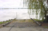
Shallow, weedy lake with a fringe of cumbungi and a mud bottom. Only a small stretch of water (60 m) can be fished from the bank because of riparian cumbungi. Main angling species are redfin, golden perch and European carp. Also contains tench, silver perch, bony bream, goldfish, some Murray cod and possibly freshwater catfish. Stocking of chemically marked golden perch and dart tagged Murray cod commenced in 2003 following the buy-back of inland commercial fishing licences, and continued in 2008. Success of this stocking will be evaluated by fish surveys (stock assessment), analysis of fish samples (marked golden perch) and angler surveys. Results will be published
Middle Lake
2,210 ha. Ramsar listed.
A very weedy lake surrounded by private property, lignin and dense beds of cumbungi. This lake has the main ibis rookery. Boating is prohibited. Seldom fished because of difficult access to the water's edge. Probably contains the same species as Reedy Lake. Most fishing occurs in the channels connecting the lakes.
Third Lake
232 ha. 2,800 ML. Ramsar listed.
Abundant dead timber, with very little aquatic weed. Open to boating. Same species as Reedy Lake. Most fishing occurs in the channels connecting the lakes.
Round Lake, Swan Hill
20 ha. 490 ML. Very saline.
A drainage swamp surrounded by vineyards. May contains European carp but is not recommended as an angling water.
Serpentine Creek, Durham Ox
Flows from the Loddon River via Bears Lagoon, becomes Pennyroyal Creek and ends in Tragowel Swamp. A wide (30-40 m) sluggish creek with turbid water. Has low banks with riparian vegetation of reeds, cumbungi and river red gums at Durham Ox. Good water depths (100 cm), some instream snags and aquatic vegetation. Good instream habitat. Main angling species are abundant golden perch, redfin and European carp. Also goldfish, eastern gambusia, Australian smelt and flathead gudgeon. No recent records of Murray cod. Stocked with golden perch around Durham Ox.
Tutchewop Lake, Benjeroop
775 ha. 20,000 ML. Permanent saline. Ramsar listed.
A shallow lake surrounded by open saltbush country, mud bottom. Filled by pumping and water level fluctuates. Used as a saline water evaporation basin and for salt and mineral extraction. Dry in 2008/09.
Wandella Lake, Kerang
80 ha. 1,230 ML. Very saline. Also called Brandy Lake.
A shallow lake surrounded by farmland, mud bottom. Used to carry redfin, European carp and tench but now reported to carry no fish as it is saline.
Waranga Western Channel
An irrigation channel flowing through flat farmland. The whole length of the channel is popular for fishing but access is a problem as it flows through private property. Reported to contain silver perch, European carp, redfin, tench, brown trout, and Murray cod.