La Trobe

- Ada River
- Bear Creek
- Billy Creek
- Blue Rock Lake
- Clear Lake
- Flynns Creek
- Hawthorn Creek
- Hazel Creek
- Hazelwood Pondage
- Hyland Lake
- La Trobe River
- Little Morwell River
- Loch River
- Middle Creek
- Moe River
- Moondarra Reservoir
- Morwell Lake
- Morwell River
- Narracan Creek
- Narracan Lake
- O'Gradys Creek
- Pioneer Creek
- Red Hill Creek
- Rintouls Creek
- Shady Creek
- Tanjil River
- Toorongo River
- Traralgon Creek
- Tyers River
- Wilderness Creek
- Yallourn Storage Dam
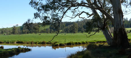
The basin extends south to north from the Strzelecki Ranges to the Great Dividing Range. It consists of an elongated central area of flat cleared farmland with unconsolidated soils, (potential for bank erosion), plus a larger northern and smaller southern area of forested, steep mountain and/or hills. The La Trobe River originates as a number of tributaries in several high rainfall areas (mean annual 1,000-1,400 mm and 1,400+ mm) resulting in a very reliable flow regime and a large waterway, downstream. Rainfall elsewhere is in excess of 700 mm per year except in the eastern area where it varies from 500-700 mm.
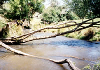
Land use in the central La Trobe Valley is grazing and broad acre cropping with intensive cropping of potatoes in rolling hills at Thorpdale. The largest river is the La Trobe which flows for over 80 km, discharging into Lake Wellington. A clear separation can be made between streams flowing through forest and those in farmland. The former (mostly in the north-western area) are in excellent condition with native riparian vegetation, coarse substrate with little or no sedimentation, fast-flowing riffles, good pools, clear water and good summer flow. They contain excellent habitat for biota and provide a good environment for fish. Streams flowing through farmland, including the middle and lower reaches of the La Trobe River are in poor condition.
Brown trout and river blackfish are common in various tributaries of the La Trobe River but scarce in the main channel downstream of Lake Narracan. European carp have become established in the lowland waterways. Some waters in this Basin are commercially fished for short-finned and long-finned eel.
Freshwater Fish in the Basin
Native species
- (Large fish): Australian bass, Australian grayling, Gippsland spiny crayfish, long-finned eel, river blackfish and short-finned eel.
- (Small fish): Australian smelt, congoli, eastern dwarf galaxias, flathead gudgeon, pouch lamprey, shorthead lamprey and southern pygmy perch. The spiny crayfish, Euastacus wolwuru, which has no common name,is also present.
Introduced species
- Brown trout, #convict cichlid, #blue acara, #red devil cichlid, #spotted tilapia, eastern gambusia, European carp, goldfish, rainbow trout, redfin and tench.
(# tropical aquarium fish which have been illegally introduced into Hazelwood Pondage).
Native species in bold are protected in this Basin. Introduced species in bold are declared noxious.
There is an absence of galaxias species, with Australian smelt and southern pygmy perch now the most abundant of the small-sized native fish. Introduced fish species are now common and widespread in the lowland streams.
Management
See Introduction for information on Management Agencies and Programs.
The Victorian Fisheries Authority
- manages stocking, fisheries policy, compliance with fisheries regulations and contact with anglers.
- Fisheries Management Plan (FMP) (a recent project that provides recreational anglers, government agencies and other stakeholders with clear guidance on fisheries management issues with a regional area over a five year period).
A FMP for waters within this Basin has been completed and was declared in July 2008. It can be viewed on the website. (West Gippsland Fishery Management Plan no. 56) - Stocking Program (stocking plans for desirable species are based on an approved Victorian Fisheries Authority stocking policy and are reviewed annually via Vic Fish Stock). In this Basin, Lake Narracan and Blue Rock Lake are regularly stocked with trout and Australian Bass are also being released when available. All the rivers carry self-sustaining populations of fish.
Up-to-date information on numbers and size of each species stocked can be found under Fish Stocking in the Fisheries and Aquaculture section of this website or in the annual Vic Fish Stock Report published by the department. - Family Fishing Lakes Program (an ongoing project of stocking small waters within urban areas with larger trout, for junior and disabled anglers – see Introduction for further information). The water within this basin is Morwell Lake.
- Premier Lakes Program (five Family Fishing Lakes in the State have been selected as Premier Lakes. They will have access for all anglers and be provided with facilities such as toilets, BBQs, picnic tables and playground equipment to encourage families and new anglers to go fishing. They will be stocked with large {>1kg} rainbow trout – see Introduction for further information) The Premier Lake in this basin is Hyland Lake at Churchill.
- Victorian Stream Classification (a project that was completed in November 2010, which classifies each water as a native, salmonid or mixed fishery). Classifications relevant to this basin are:
- Trout - the Toorongo and Loch rivers. Tanjil River upstream of Blue Rock Reservoir, La Trobe River upstream of Mount Hawthorn Creek.
- Mixed - La Trobe tributaries, Tanjil, Moe, Tyers and Morwell rivers. Hazelwood Pondage.
- Native - La Trobe River and tributaries downstream of Tyers and Thomson Valley Tyers road.
West Gippsland Catchment Management Authority
- responsible for catchment management and the Victorian River Health Program.
- Victorian River Health Program (an on-going State Government initiative to achieve healthy rivers, streams and floodplains). Major activities are removal of willow and pest plants and the protection of banks by fencing, re-establishing native vegetation and engineering works when necessary. Work has been done on the La Trobe, Moe and Morwell Rivers and the Traralgon Creek
Gippsland & Southern Rural Water
- manages farm and irrigation water diversion and the development of Stream Flow Management Plans.
- Stream Flow Management Plans (an ongoing project in which various agencies and water users develop a flow sharing arrangement which ensures an adequate environmental flow allocation for each river in Victoria. Stream flow management plans have been completed for the Upper La Trobe River and are being prepared for the Morwell River.
Gippsland Water
- manages urban water diversion.
Best Fishing Waters
| Water | Target Species |
|---|---|
| Blue Rock Lake | European carp, brown trout, redfin |
| Hyland Lake | Rainbow trout |
| La Trobe River,upstream of Noojee | Brown trout, small river blackfish |
| Morwell River, upstream of Boolara | Brown trout, river blackfish |
| Narracan Lake | European carp, redfin |
| Tanjil River, below Blue Rock Lake | Brown trout, eels |
Special Values
Ramsar Sites
(wetlands of international significance - Convention on Wetlands, Ramsar, Iran 1971).
The Gippsland Lakes, which are the receiving body for all water flowing out of this Basin.
Threatened Fish Species
The Australian grayling and the eastern dwarf galaxias are listed as threatened species in Victoria. (Department of Sustainability and Environment [DSE] Dec. 2007). A list of Victorian threatened species together with scientific names of species, a definition of the terms used and their national status is available on the DSE web site.
Species in bold type are also listed under the Flora & Fauna Guarantee Act 1988. These species cannot be taken or kept within Victoria without a written order, licence or permit issued by the Director-General.