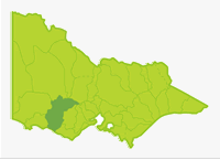
Hopkins
- Alexandra Lake
- Beaufort Lake
- Bolac Lake
- Bookar Lake
- Burrumbeet Creek
- Burrumbeet Lake
- Cartcarrong Lake
- Cobrico Lake
- Dawsons Dam
- Deep Lake
- Fiery Creek
- Goldfields Lake
- Gillear Lake
- Greenhill Lake
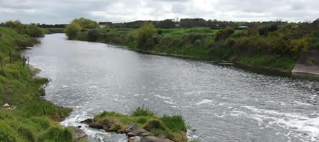
- Hopkins River
- Jubilee Lake
- Learmonth Lake
- Logans Lake
- Merri River
- Mount Emu Creek
- Mumblin Lake
- Musical Gully Reservoir
- Muston Creek
- Norval Dam
- Norville Dam
- Shallow Lake
- Tea Tree Lake
- Winslow Lake
This is a large basin with predominantly flat terrain except for low rolling hills in the north of the Basin in the headwaters of the Hopkins River and Fiery Creek and another small area east of Dunkeld. Soils are finely textured unconsolidated deposits, with volcanic rock in the plains and sedimentary and granitic rocks in the hill country.
This basin is almost totally cleared for agriculture such as grazing and some broad acre cropping. Some small areas of low mixed species forest occur in the hills, north of Beaufort. All the rivers flow through grassland and riparian tree cover is usually absent apart from scattered individual trees. Mean annual rainfall is 700-1,000 mm in the far north and south of the Hamilton Highway but the large central area only receives from 500-700 mm.
The absence of forests, predominance of finely textured soils and low rainfall results in sluggish, mud-bottom streams with low summer flows. Most waterways have quite high salinity during summer, which has the potential to adversely affect freshwater ecosystems. The volcanic rock provides some basalt, rubble and rock in the larger rivers. However the generally poor habitat conditions in most rivers is compensated by the numerous lakes, which provide excellent fishing.
Some lakes are brackish to saline. Short-finned eels are abundant and some waters in this Basin are commercially fished for them. The Hopkins River is the main waterway and its largest tributary, Mount Emu Creek, drains the eastern side of the Basin.
Freshwater Fish in the Basin
Native species
- (Large fish): Australian grayling, estuary perch, river blackfish, and short-finned eel.
- (Small fish): Australian smelt, common galaxias, congoli, flathead gudgeon, mountain galaxias, dwarf galaxias, pouch lamprey, trout galaxias southern pigmy perch and Yarra pygmy perch.
Introduced species
- Brown trout, eastern gambusia, European carp, goldfish, rainbow trout, redfin, roach and tench.
Native species in bold are protected in this Basin. Introduced species in bold are declared noxious.
The most common angling species in the rivers are redfin and short-finned eel. Brown trout are only common in the lower Merri River (downstream of the weir), the freshwater section of the Hopkins River and in stocked lakes. Small native fish are quite common and widespread and very abundant in the upper Merri River. River blackfish are restricted to the freshwater section in the Mount Emu Creek and Hopkins River. They were probably more widespread before water salinity increased.
Management
See Introduction for information on Management Agencies and Programs.
The Victorian Fisheries Authority
- manages stocking, fisheries policy, compliance with fisheries regulations and contact with anglers.
- Fisheries Management Plan (FMP) (a recent project that provides recreational anglers, government agencies and other stakeholders with clear guidance on fisheries management issues with a regional area over a five year period).
A FMP for waters within this Basin has been completed and was declared in October 2006. It can be viewed on the website. Fisheries Victoria Report Series. Glenelg Hopkins FisheryManagement Plan. No. 42. October 2006. - Stocking Program (stocking plans for desirable species are based on an approved Victorian Fisheries Authority stocking policy and are reviewed annually via Vic Fish Stock). In this Basin, Lakes Beaufort, Cartcarrong and Gillear; and the Hopkins, Merri and Moyne Rivers and the Mount Emu Creek are the only waters being stocked with trout during the drought. In normal years, Lakes Bolac, Deep, Greenhill and Learmonth are stocked regularly and Lake Burrumbeet is stocked occasionally.
Up-to-date information on numbers and size of each species stocked can be found under Fish Stocking in the Fisheries and Aquaculture section of this website or in the annual Vic Fish Stock Report published by the department. - Family Fishing Lakes Program (an ongoing project of stocking small waters within urban areas with larger trout, for junior and disabled anglers – see Introduction for further information). Waters in this Basin are Alexandra Lake, Jubilee Lake and Tea Tree Lake.
- Premier Rivers Program(Three river sections in Victoria have been selected as Premier Rivers under the Go Fishing in Victoria initiative. They have been chosen for their existing high recreational fisheries values and will be provided with improved access and other facilities to assist anglers. Information packages will be developed for each river to increase awareness of the fishing opportunities and facilities available). The Premier River in this Basin is the Hopkins estuary.
- Victorian Stream Classification (a project that was completed in November 2010, which classifies each water as a native, salmonid or mixed fishery). Classifications relevant to this basin are:
- Trout- Merri River downstream of Drysdale Creek to Princes Highway, Mount Emu Creek from Hopkins River junction to Skipton.
- Mixed- All other waters including Hopkins River downstream of the Hopkins Falls and Merri River downstream of Bromfield Weir.
Glenelg Hopkins Catchment Management Authority
- is responsible for catchment management and the River Health Program.
- Victorian River Health Program (an on-going State Government initiative to achieve healthy rivers, streams and floodplains). Major activities are erosion control, bed and bank stabilization, willow and weed removal, fencing and replanting banks.
Gippsland and Southern Rural Water
- manages rural water diversion for irrigation/stock use and the development of Stream Flow Management Plans.
- Stream Flow Management Plans (an ongoing project in which various agencies and water users develop a flow sharing arrangement which ensures an adequate environmental flow allocation for each river in Victoria). A Stream Flow Management Plan has been completed for the Merri River.
Central Highlands Water and Wannon Water
- manage urban diversion and supply.
Best Fishing Waters
| Water | Target Species |
|---|---|
| Hopkins River | Brown trout |
| Hopkins River estuary | Estuary perch, black bream |
| Lower Merri including the estuary | Brown trout, black bream, estuary perch, mullet |
Special Values
Ramsar Sites
(wetlands of international significance - Convention on Wetlands, Ramsar, Iran 1971)
Lake Bookar.
Threatened fish Species
The Australian grayling, Yarra pygmy perch and dwarf galaxias are listed as threatened species in Victoria. (Department of Sustainability and Environment [DSE] Dec. 2007). A list of Victorian threatened species together with scientific names of species and a definition of the terms used and their national status is available on the DSE web site.
Species in bold type are also listed under the Flora & Fauna GuaranteeAct 1988. These species cannot be taken or kept within Victoria without an appropriate written order, licence or permit.