West Gippsland Fishery Management Plan
Fisheries Victoria Management Report Series No. 56
July 2008
ISSN: 1448-1639
Preferred way to cite this publication:
Department of Primary Industries (2008). West Gippsland Fishery Management Plan 2008. Fisheries Victoria Management Report Series No. 56
Executive summary
The purpose of the West Gippsland Fishery Management Plan (WGFMP) is to specify the objectives, strategies and actions for managing fishing activities within the West Gippsland Fishery.
The West Gippsland Fishery includes all inland waters (as defined in the Fisheries Act 1995) in the area administered by the West Gippsland Catchment Management Authority. The WGFMP does not cover Shallow Inlet, Anderson Inlet, Corner Inlet and Noormunga, the western end of the Gippsland Lakes (including Lake Wellington), and any coastal waters.
The Fishery, for the purposes of this plan, does not include commercial bait and eel fishing or aquaculture ventures as these are managed through other planning processes.
The WGFMP prescribes fishery management arrangements in accordance with a nationally agreed framework for applying the principles of Ecologically Sustainable Development to fisheries.
The WGFMP describes the main fishing waterways and impoundments and key recreational target species; current management arrangements for recreational fishing activities; goals, objectives, performance indicators and actions for management of recreational fishing activities; and processes for participating in management of other relevant issues to ensure possible negative consequences to fish habitat are identified and responsible agencies notified.
In view of the lack of detailed information on recreational fishing and key fish habitats in the West Gippsland Fishery, existing management arrangements will initially remain unchanged. Actions to be implemented in the West Gippsland Fishery over the next five years include:
- establishing monitoring programs for key target fish species
- preparation of a Stream Classification Model to identify Native, Mixed and Salmonid fisheries
- stocking of fish in support of recreational fishing in suitable waters
- establishment of an Australian bass fishery
- providing advice to habitat resource managers with the aim of achieving better outcomes for key fisheries resources
- identifying opportunities to improve access to fisheries resources through the Victorian Recreational Fishing Peak Body
Priorities for implementation and indicative costs of the actions identified in the WGFMP are provided. If information from proposed programs indicates a need to alter fishery management arrangements in the future to ensure sustainable use or to meet changing demands for recreational fishing opportunities, then changes will be considered in consultation with stakeholders.
Annual progress reports and a five-year review process will allow fishery management arrangements for the West Gippsland Fishery to be adapted to changing circumstances, and ensure sustainable use of fisheries resources with economic and social benefits to the community.
A West Gippsland Fishery Reference Group will be established to work with the Department of Primary Industries to deliver the desired outcomes for the West Gippsland Fishery. It is proposed that the reference group include representatives from recreational fishers, public land managers, water management authorities and Indigenous interests. Other groups or individuals may be engaged as required.
Introduction
The Fisheries division (Fisheries Victoria) of the Department of Primary Industries (DPI) works with its stakeholders to facilitate the sustainable development of fisheries resources. A key task in sustainable management is the preparation and implementation of fishery management plans.
Fishery management plans specify the objectives, strategies, actions and performance measures for managing fishing activities in accordance with the principles of Ecologically Sustainable Development (ESD).
Recreational fishing is the primary fishing activity in Victoria's rivers, tributaries, lakes, estuaries and impoundments. Other fishing activities in inland areas of Victoria include commercial bait fishing, aquaculture and eel fishing (refer to the Victorian Eel Fishery Management Plan). Inland fishery management plans focus on managing recreational fishing activities with the aim of enhancing social, environmental and economic outcomes. Inland fishery management plans also recognise the importance of fisheries resources to Indigenous communities.
Effectively managing inland fisheries requires the implementation of appropriate fisheries management tools (for example, bag and size limits), but also a recognition that other anthropogenic activities in the catchment are equally, if not more, important in sustaining fish stocks. Therefore, inland fishery management plans are prepared with a strong focus on establishing partnerships with relevant catchment and water management agencies.
The West Gippsland Catchment Management Authority (WGCMA) is one of ten Catchment Management Authorities that have responsibility for managing catchments and waterways in Victoria. Catchment Management Authorities (CMAs) develop and implement Regional Catchment Strategies (RCSs) and their substrategies, the Regional River Health Strategies (RRHSs).
To create effective alignment of catchment and fishery management strategies and the efficient delivery of management actions, the West Gippsland Fishery Management Plan (WGFMP) has been aligned with the boundaries of the WGCMA. The WGFMP also recognises that management of fishery resources must also occur at larger scales across CMA boundaries. Fisheries Victoria has identified management units where similar species and ecological characteristics are found and will enable management of these units on a statewide basis.
The WGFMP will provide management direction for fishing activities across the Fishery. This area includes all inland waterways in the South Gippsland, Latrobe and Thomson basins. The WGFMP will not cover Shallow Inlet, Anderson Inlet, Corner Inlet and Noormunga, the western end of the Gippsland Lakes (including Lake Wellington), or any coastal waters to three nautical miles.
The goal of the WGFMP is to manage fisheries resources in the West Gippsland Region in accordance with principles of ESD (Fletcher et al. 2002). The aim of ESD is to enable the ongoing use, conservation and enhancement of the fisheries resources such that ecological processes are maintained into the future and, where possible, usage is enhanced. In the context of the WGFMP, ESD involves research to demonstrate the sustainable harvest of fisheries resources, identification of the habitats and aquatic environments on which fisheries resources depend, and enhancing social and economic benefits for all Victorians.
West Gippsland Region
The West Gippsland Region (Figure 1) comprises approximately 17,700 square kilometres and covers a general area from the western part of the Gippsland Lakes in the east, Wilsons Promontory in the south, the Great Dividing Range in the north and west of Warragul. The three major catchments of the region are the Latrobe, Thomson and South Gippsland basins (WGCMA 2004).
The South Gippsland catchment occupies the western part of the region and is characterised by relatively small and independent river systems (for example the Franklin, Tarra, Agnes, Powlett, Tarwin and Albert rivers) and Merrimans, Pound and Screw creeks that flow from the southern slopes of the Strzelecki Ranges to Bass Strait or into small estuaries (WGCMA, 2004).
The Latrobe catchment occupies the central part of the West Gippsland Region with rivers rising on the southern side of the Great Dividing Range and the northern side of the Strzelecki Ranges and draining into Lake Wellington, the western most part of the Gippsland Lakes. The Latrobe, Tanjil, Tyers and Moe rivers and the Morwell and Traralgon creeks are characterised by large catchments with forested upper reaches, extensive floodplain areas in the middle reaches and connectivity with freshwater marshes and estuarine environments on the lower reaches.
The Thomson catchment occupies the eastern part of the West Gippsland Region and extends from the southern side of the Great Dividing Range through forested upper reaches, extensive floodplains to wetland environments and freshwater marshes. This catchment includes the Thomson, Macalister, Avon and Perry rivers, Freestone and Valencia creeks and Lake Glenmaggie, Cowwarr Weir, Lake Tali Karng and the Thomson Dam.
The southern fall of the Great Dividing Range, the Strzelecki Ranges and the western part of the West Gippsland Region receive rainfall between 1000 – 1600 millimetres annually. Snow may fall on the higher peaks through the winter months. The rain shadow of Wilsons Promontory and the Strzelecki Ranges reduces the rainfall to around 600 millimetres per year (WGCMA 2004).
The West Gippsland Region supports many industries including manufacturing, power production, gas mining, water harvesting, forestry, agriculture, fishing, business and property services. Thirty-nine per cent of the population within the West Gippsland Region are employed in agriculture (beef, dairy, wool and lamb), fishing or forestry (public or private). The brown coal industry provides most of Victoria's electricity supply.
The West Gippsland Region includes municipalities of Latrobe City, and parts of Wellington, Baw Baw, South Gippsland, Bass Coast and sparsely populated areas of East Gippsland and Delatite (WGCMA 2004).
The population in the West Gippsland Region is approximately 169,000 people and is dispersed between several regional centres in the vicinity of South Gippsland, Strzelecki, Bass and Princes Highways (WGCMA 2004). Morwell, Traralgon and Sale are considered to be major regional towns.
Key asset groups
As a basis for strategic statewide fisheries management, Fisheries Victoria has identified regions with similar environmental, geomorphological and fishery species characteristics. Similar areas have been grouped into key asset groups. The West Gippsland Region contains the following fisheries key asset groups which will assist in identifying and describing issues:
- rivers
- estuaries
- impoundments
Fisheries key asset groups are a tool to assist in the identification and prioritisation of issues at a strategic level and therefore allow common issues to be grouped together and addressed with a strategic approach. In particular, the key asset groups recognise the West Gippsland CMA's model for investment and enable the establishment of partnerships for management outcomes at common geographic scales.
Key asset groups will not be used as a vehicle for introducing different fishing regulations at smaller spatial scales within the waters of the West Gippsland Region. In addition, the boundary between rivers and estuaries may change seasonally as a result of fluctuations in river flows and water levels.
The following sections provide information on the recreational fishing species generally found in each key asset group. Information has been obtained from the Guide to Inland Angling Waters of Victoria www.depi.vic.gov.au/angling/, from Fisheries Victoria regional staff and through public consultation processes undertaken during the development of the WGFMP.
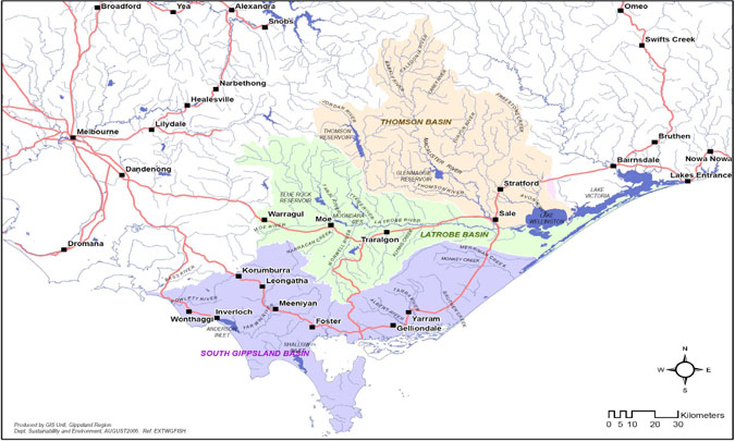
Figure 1: Map of the West Gippsland Region (coloured areas)
Rivers
Rivers in the West Gippsland Region typically contain a mix of native and introduced species and, for comparison purposes to other management plans, are broadly similar to 'Midland' or 'mixed species' rivers reflecting the mix of warm water and cold water species that occur. The Rivers key asset group includes forested coastal streams, wide slow-flowing rivers running through grazing and agricultural land and smaller inland creeks.
Anecdotal reports from the first round of public consultation indicate that the most popular fishery species for this key asset group include brown and rainbow trout, Australian bass, river blackfish, tupong, eels, black bream, estuary perch and Gippsland spiny freshwater crayfish.
There is evidence of self sustaining populations of brown trout in the Tarwin River and upstream of Lake Glenmaggie in the Macalister River. A popular and productive brown trout fishery exists in the Macalister River downstream of Lake Glenmaggie and in the Tanjil River downstream of Blue Rock Lake. Brown trout have been stocked into the Macalister River upstream and downstream of Lake Glenmaggie and rainbow trout have been stocked into the Tarwin and Macalister rivers.
The upper sections of the Thomson, Macalister and Tanjil rivers are considered popular angling locations for recreational fishers. The Thomson River downstream of the Thomson Dam is considered a good river blackfish and eel fishery, while fishing for brown trout and small river blackfish is considered good on the Latrobe River upstream of Noojee. With the Thomson Dam closed to fishing activities, the catchment above the dam is considered by anglers to offer some of the best waters in the West Gippsland Region to target large trout and river blackfish. The Easton Portal is renowned for excellent catches of quality brown and rainbow trout and river blackfish which may reach more than a kilogram. The installation of the fishway at the Easton Portal allows passage of native and introduced species from the Thomson Dam to the upper reaches of the Thomson River.
Anecdotal reports indicate that Lake Tali Karng (situated at the head of the Wellington River) is also considered an excellent fishery for trout and river blackfish with some reports of freshwater crayfish being present.
The Fisheries Regulations 1998 defines the Tanjil River and its tributaries between Blue Rock Lake and the junction of the Tanjil and Latrobe rivers as 'Tailrace' rivers. These rivers are formed when cool water is released into rivers from impoundments.
Current regulations for 'Tailrace' rivers can be found in the Victorian Recreation Fishing Guide, but at the time of writing, the regulations include a range of bag and size limits and a closed season. 'Tailrace' rivers are closed to all fishing from midnight of the Queen's Birthday weekend in June each year to midnight on the Friday before the first Saturday in September.
During this period, fishing is permitted in other rivers and streams, but taking trout is prohibited. Therefore, impoundments provide an important year-round recreational fishing opportunity for trout anglers in the West Gippsland Region.
'Tailrace' rivers support significant numbers of large trout (greater than 1 kilogram) because habitat conditions, including year round water temperatures and flows, are favourable to supporting self-sustaining trout populations.
Profile of recreational fishing in the Macalister River
Anglers in the Macalister River were surveyed from September 2003 to June 2004 to determine angler catches during the trout open season to investigate concerns over low catch rates within the system (DPI 2006a). The creel survey has been the only assessment for the Macalister River (upstream of Lake Glenmaggie) and the lower reaches of the Wellington River.
In summary, the study found:
- the Macalister River is highly regarded as a 'good' to 'excellent' fishery
- the most popular method of fishing was bait fishing, while the most effective method was a combination of lure and bait fishing
- the highest angler patronage was from Melbourne and surrounding postcodes
- almost a quarter of anglers surveyed were considered local, indicating a high use of the river by residents of the district
- fishing pressure was found to be at its greatest in January and March although trout catches were at the lowest for both species during the same period
- the greatest fishing pressure occurred between Paradise Valley to Cheynes Bridge with the greatest angling success occurring in the Wellington River, Cheynes Bridge to Basin Flat and Abbotts Road to Paradise Valley
- the best fishing for trout was within the months of April to June for brown trout and November to December for rainbow trout.
Anecdotal evidence suggests that fly fishing is also an effective fishing method in the Macalister River.
Outcomes of other smaller studies relevant to the West Gippsland Fishery can be found in Appendix 2.
Fishing catch and effort in the Macalister River
A specific study to determine the recreational fishing catch and effort in the Macalister River was undertaken between September 2003 and June 2004 (DPI 2006a).
The catch per unit effort for all species was highest for carp, with smaller catches of Australian bass, redfin and brown and rainbow trout observed.
The estimated total catch of brown trout over the survey period was 917 fish with a catch rate of 0.14 fish per hour. The estimated total catch of rainbow trout was 339 with a catch rate of 0.05 fish per hour (DPI 2006a).
The survey also indicated proportionally low catch rates of fin-clipped brown trout and indicated that the greater proportion of brown trout found in the Macalister River are spawned naturally in the system. The survey also concluded that stocking has little effect on the overall catch rates for brown trout and that further supplementary stocking of trout is not recommended as it appears that stocked individuals are unlikely to survive in any number from year to year (DPI 2006a).
Outcomes of other smaller studies relevant to the West Gippsland Fishery can be found in Appendix 2.
Impoundments
The impoundments key asset group describes all static water bodies, including lakes and impoundments that support or have supported fish species targeted by recreational fishers across the West Gippsland Region. Many impoundments have been stocked and are popular areas for recreational fishing.
The most popularly fished impoundments and the key recreational target species likely to be found within them are described in Appendix 1. Public consultation suggested that Lake Glenmaggie and Blue Rock Lake are considered the most popular impoundments for recreational fishing. Smaller impoundments such as Lake Narracan, Easton Portal and Lake Tali Karng are also popular.
Lake Glenmaggie, located on the Macalister River, is an irrigation storage area. The level fluctuates widely with the lake drawn to low levels in most years. Lake Glenmaggie is considered a mixed fishery with rainbow trout and Australian bass the main target species for recreational angling. Access to the water is from the shoreline when water levels are adequate. Three boat launching ramps exist and provide access to boat users.
Blue Rock Lake, located on the Tanjil River, is principally a brown trout fishery. Australian bass, carp and redfin can also be targeted. While boating is permitted, vessels may be no longer than 4.3 metres, can only travel at a maximum of five knots, and have a motor with a maximum of 7.5 kilowatts (10 horse power). Good shore-based fishing is available on the western side of the Lake. This impoundment has been stocked with brown trout for the past six years.
Lake Narracan receives water from the Latrobe and Tanjil rivers to provide cooling water for the Yallourn Power Station. The lake level fluctuates widely and has extensive shallows at the western end. Lake Narracan is popular for boating activities including water skiing. This storage facility is considered to be an important brown and rainbow trout, carp and redfin fishery. This impoundment has been stocked with rainbow and brown trout for the past three years.
Family fishing lakes
The Impoundments management unit also includes water bodies managed as part of Fisheries Victoria's Family Fishing Lakes Program.
The Family Fishing Lakes Program (previously known as the Small Waters Program) stocks readyto- catch advanced yearling rainbow trout (150 – 200 grams) into suitable impoundments. The primary purpose is to provide recreational fishing opportunities for anglers of all ages and abilities.
Family Fishing Lakes are situated within or close to population centres throughout Victoria and offer good access. Stockings of these rainbow trout are aligned with the second and or third term school holidays plus any Fishing Week or junior fishing clinic events. This generally coincides with water temperatures best suited to trout.
Family Fishing Lakes in the West Gippsland Region are detailed in Appendix 1 and include Guthridge and Guyatt lakes (Sale) and Morwell Lake.
Premier lakes
As a part of the Go Fishing in Victoria initiative, five of the Family Fishing Lakes have been selected for development as Premier Lakes.
Within the West Gippsland Region, Hyland Lake, which is located near Churchill in central Gippsland, has been chosen as a Premier Lake. Hyland Lake has long been a popular fishing spot for families.
Premier Lakes have a guaranteed standard of access for disabled fishers, and feature family friendly facilities such as toilets, BBQs, picnic tables and playground equipment. Premier Lakes will be partly stocked with larger Premier rainbow trout at least four times per year (subject to suitable water conditions).
Premier Lakes will be the focus of Family Fishing events; fun days when families and kids can learn to catch a fish. These events are planned and run by DPI in partnership with VRFish, local angling clubs, local shires, Fishcare volunteers and other stakeholders.
Hyland Lake is currently undergoing additional redevelopments, including the installation of a fifth fishing platform and a large modern picnic and BBQ facility which has been funded through the Go Fishing in Victoria initiative. These redevelopments will be completed in 2008.
Stocking of Premier rainbow trout fish at Hyland Lake will commence in 2008.
Estuaries
The estuaries of the West Gippsland Region support a diverse range of fish species. The key recreational target species include black bream, Australian bass and estuary perch.
The seaward boundary of each estuary is described by the extent of inland waters in the Fisheries Act 1995. The inland limits of each estuary (beyond which the river is considered to be freshwater) have not been described.
Recreational fishing effort is high in most estuarine environments of the West Gippsland Region. Fishing for estuary perch is considered good in the lower reaches of the Franklin, Albert, Avon, Latrobe, Tarra and the Tarwin rivers and Merrimans creek. The black bream fishery is considered excellent in the estuarine sections of the Avon, Latrobe, Powlett and Tarwin rivers as well as Screw and Merrimans creeks.
The lower section of the Avon River is also renowned for an annual mullet run.
A sea run trout fishery has also been declared on the Avon River, downstream of the Stratford Railway Bridge. These waters are known to contain populations of sea-run brown trout that provide salmonid angling opportunities during the salmonid closed season.
Information on fishing restrictions and regulations while fishing in a nominated sea-run trout river can be found in the Victorian Recreational Fishing Guide.
Commercial fishing
Commercial fishing activity within the West Gippsland Region is considered limited. There is minimal commercial harvest of native and introduced fish species.
Some commercial activity occurs in the larger bays and inlets within the West Gippsland Region (for example Corner Inlet and the western area of Gippsland Lakes). These waters are not part of the West Gippsland Fishery.
The eel fishery is managed in accordance with the Victorian Eel Fishery Management Plan (DNRE 2002a).
The Victorian commercial eel fishery is an important State fishery and involves the harvesting of the short-finned and long-fined eel.
This fishery is input managed, with the main management controls being limited entry, gear restrictions and the allocation of licences and or permits for a limited number of specified waters. Holders of Eel Fishery Access Licences may take eels for sale. Within the West Gippsland Region, holders of these licences are authorised through licence conditions to fish in the following waters:
- Franklin River downstream from the South Gippsland Highway, Agnes River downstream from the South Gippsland Highway
- all rivers, creeks, channels and drains downstream from the South Gippsland Highway between Dandenong and the junction from the South Gippsland and Bass Highways. All rivers creeks, channels and drains downstream from the Bass Highway between the junction of the South Gippsland and Bass Highways and Wonthaggi.
With some exceptions, Eel Fishery Access Licence holders may fish in lakes, dams, swamps, marshes or morasses south of the Great Dividing Range. Licence holders may also apply for specific permits to harvest eels from Wildlife Reserves.
Individuals or groups wanting more information on the commercial eel fishery may refer to the Victorian Eel Fishery Management Plan (DNRE 2002a).
Aquaculture licences
Under various licences authorising inland aquaculture, licence holders may grow trout, eels, abalone, yabbies, warmwater finfish and ornamental fish for harvest and sale. At the time of writing, a total of 4 aquaculture licences have been issues within the West Gippsland Region.
Bait licences
There are currently no bait licences authorising the commercial harvest of bait species in the waters of the West Gippsland Region.
Noxious aquatic species permits
At the time of writing, two operators are authorised via permits under the Fisheries Act 1995 to harvest carp in waters of the West Gippsland Region.
Biology and ecological requirements of key native and introduced recreational fishery species
The following descriptions of the biological and ecological characteristics of key target fish species in the West Gippsland Region are derived from published literature and anecdotal reports. While some recreational fishers have extensive knowledge of the distribution and behaviour of key fish species in the West Gippsland Region based on personal observations, there has been little or no scientific investigation of the distribution, population dynamics or ecological requirements of fish species in the region. The list of species for the WGFMP has been identified from the public consultation process and anecdotal evidence and is not considered to be a definitive list of key target species.
Key fish species
Public consultation suggested that in recent years, the main target species for recreational fishers in the West Gippsland Region have been brown and rainbow trout, estuary perch, Gippsland spiny freshwater crayfish, black bream, Australian bass, redfin and river blackfish. Smaller catches of tupong, mulloway, eels, carp and luderick are also reported.
Key native recreational fishery species
Estuary perch (Macquaria colonorum)
Estuary perch are resident in estuaries of southeastern Australia from northern NSW through Victoria and Tasmania to the mouth of the Murray River in South Australia (Williams 1970).
Examination of fish caught in netting surveys of Victorian estuaries indicated that estuary perch spawn during winter and spring months (McCarraher & McKenzie 1986). Spawning usually begins later in western estuaries than in the east. Estuary perch in spawning condition were most often found in waters with salinities between 10 and 24 parts per thousand and over seagrass, algal beds or rocky reefs.
The Victorian netting surveys indicated that estuary perch were generally abundant in Gippsland estuaries and that they grew and survived best in estuaries containing deepchannelled rivers and frequently or permanently open entrances.
Little is known of the early life history stages of estuary perch, but nursery areas for small juveniles are thought to be in the upper reaches of estuaries. Larger juveniles and adult perch are known to be associated with submerged tree branches and seagrass beds where they can shelter and feed as ambush predators on smaller fish and crustaceans such as crabs and shrimps.
Anecdotal reports from public consultation and accounts from local Fisheries Officers suggest that the estuary perch fishery in the West Gippsland Region is popular in the Powlett, Avon, Tarra, Albert and Agnes rivers and Screw, Pound, Merrimans and Cherry Tree creeks. The species is also targeted in the Tarwin River (east branch).
Black bream (Acanthopagrus butcheri)
Black bream (Acanthopagrus butcheri) is an endemic species, which inhabits estuarine waters of southern Australia from southern NSW to Western Australia. The range of black bream overlaps with the closely related yellowfin bream (Acanthopagrus australis) in southern NSW and East Gippsland (Kailola et al. 1993). These two species are morphologically similar and are known to hybridise in some areas (Rowland 1984).
Black bream is a demersal species and may be found in association with rocky river beds, snags and man-made structures such as jetties. Black bream are also caught over seagrass beds, mud and sand substrates (Kailola et al. 1993; Cashmore et al. 2000). Black bream are rarely found at sea although some adult bream may migrate between estuaries (Hall 1984).
Larvae and small juvenile black bream are thought to be found primarily amongst seagrass beds because of the availability of small invertebrate prey and adequate shelter for the species (Kailola et al. 1993; Cashmore et al. 2000).
Spawning for this species can occur from August to January in any given year, but the peak is usually in October/November. Black bream spawning usually begins later in western Victorian estuaries than in Gippsland estuaries (Cadwallader & Backhouse 1983).
The survival of black bream larvae is dependent on suitable salinity and water temperature conditions as well as food and habitat availability (Kailola et al. 1993; Cashmore et al. 2000).
Female black bream first spawn at approximately 24 centimetres in length and can release between 300,000 and 3 million eggs depending on variable environmental conditions. Males become sexually mature at 22 centimetres (Butcher 1945; Hall 1984; Kailola et al. 1993).
Juvenile black bream feed primarily on polychaetes (small worms) with bivalves and amphipods are considered a secondary component of their diet (Cashmore et al. 2000). Adult black bream are considered to be opportunistic feeders, with prey items including bivalve and gastropod molluscs, prawns, crabs, polychaete worms and other small demersal fish (Rigby 1982; Kailola et al. 1993; Cashmore et al. 2000).
Anecdotal reports from local Fisheries Officers and public consultation suggested that the black bream fishery is considered good to excellent with the majority of fish caught in the Screw, Pound Merrimans and Cherry Tree creeks and the Powlett, Tarra, Agnes, Avon, Tarwin and Perry rivers. Black bream may also be found around the Swing Bridge in Sale.
River blackfish (Gadopsis marmoratus)
River blackfish are widely distributed throughout Victoria and are found north and south of the Great Dividing Range. Across the West Gippsland Region, the species may be found in many rivers and tributaries. This species is distinct from the two-spined blackfish (Gadopsis bispinosis). While both species can be found living together, river blackfish are generally found in the lower elevation, slower-flowing warmer streams.
Adult and older juvenile river blackfish prefer an abundance of snags and cover (Jackson & Davies 1983) in well oxygenated waters (Fletcher 1979). Adults can be aggressive towards other species, and are nocturnal (Frankenberg 1974; Koehn & Morison 1990). River blackfish have a limited home range between 25 – 30 metres (Koehn 1986).
River blackfish usually spawn in spring and early summer when water temperatures are approximately 16°C (Koehn & O'Connor 1990).
Eggs are strongly adhesive and may be laid in hollow logs and rock cavities (Proebsting et al., 1974) and are thought to be guarded by males (Jackson 1975). Eggs hatch around fourteen days after being laid with five week old fish found actively swimming and seeking food (Koehn & O'Connor 1990). Small juveniles spend much of their time confined to the bottom where they can be heavily preyed on by nymphs, dragonfly larvae and other crustaceans (Koehn & O'Connor 1990).
River blackfish are carnivores and feed on aquatic insects, crustaceans, small fish and molluscs (Koehn & O'Connor 1990).
Public consultation and observations from local Fisheries Officers indicated that the river blackfish are mostly targeted in the Tarwin River (east & west branch) as well as the Thomson, Little Morwell, Jordan and Aberfeldy rivers.
Australian bass (Macquaria novemaculeata)
Australian bass have a wide distribution from Tin Can Bay in Queensland to Gippsland in Victoria. The species does not naturally occur west of Wilsons Promontory (Cadwallader & Backhouse 1983). Australian bass are found in coastal rivers and lakes and can be found far upstream due to their tolerance of freshwater (Cadwallader & Backhouse 1983).
Australian bass migrate downstream into estuaries to spawn between June and early December in Victorian waters (McCarraher 1986). Australian bass require salinities of at least 14 part per thousand and a water temperature of between 14 and 19°C for spawning events (Llewellyn & MacDonald 1980; McCarraher 1986). Australian bass are known to hybridise with estuary perch in natural populations (Jerry et al. 1999).
Spawning can be induced by rising river flows (Harris 1986a), while drought and periods of decreased river flows during winter may delay or prevent reproduction (van der Wal 1983). Submerged aquatic plant beds, reefs and sandbars appear to be the preferred spawning habitat for this species (McCarraher 1986).
Males reach maturity when they are approximately 180 millimetres in length, or 3 years of age (Harris 1986), while females mature at 200 millimetres in length, or 5-6 years of age (Llewellyn & MacDonald 1980).
Larvae and juveniles are thought to remain in estuarine environments until they reach 15 – 50 millimetres in length and then migrate upstream (Koehn & O'Connor 1990). Macrophytes and structures (for example snags) provide important habitat for both juvenile and adult Australian bass. A reduction in macrophyte habitats and a decrease in water flow are thought to impact negatively on Australian bass populations (Koehn & O'Connor 1990).
Diets of larger juveniles and adults can vary widely depending on the time of year. Australian bass feed on prawns, shrimps, small crabs, amphipods, worms and fish when in estuaries (Cadwaller & Backhouse 1983) while insects, shrimps, tadpoles and small fish are eaten when in freshwater reaches (Harris 1985).
Information obtained from local Fisheries Officers observations as well as anecdotal evidence from public consultation suggested that Australian bass are targeted in Lake Glenmaggie and Blue Rock Lake as well as the Avon and Albert rivers.
Gippsland spiny freshwater crayfish (Euastacus kershawi)
The Gippsland spiny freshwater crayfish is one of ten species of spiny crayfish in Victoria and is indigenous to most creeks and rivers in Gippsland (Morey 1998). The distribution of the Gippsland spiny freshwater crayfish is from the Bunyip River in the west of Gippsland through to the NSW border (Morgan 1986).
While the genus Euastacus is well represented in eastern Australia, little information is known or has been published about the ecology and biology of the species (Morey 1998).
E. kershawi is one of the larger freshwater crayfish in Victorian waters which grows very slowly (Morey 1994). Gippsland spiny freshwater crayfish take at least 5 years to reach minimum legal length (Morey 1998). This species require monitoring to guard against over fishing in accessible waters due to slow growth rates and unknown age at maturity.
Anecdotal evidence collected from public consultation together with observations from local Fisheries Officers suggested that Gippsland spiny freshwater crayfish are regularly targeted in the Tarra, Thomson, Latrobe, Morwell and Little Morwell rivers, the upper and lower reaches of the Tanjil River, upper reaches of the Tarwin River as well as Bear and Berries creeks.
Key introduced recreational fishery species
Introduced fish species provide important recreational fishing opportunities in the West Gippsland Region. The recreational trout fishery is a major social and economic contributor to regional communities. According to the National Recreational Indigenous Fishing Survey (NRIFS) undertaken in 2000/01, the overall harvest of trout was about 800 thousand fish, 45 per cent of which were taken in Victoria, 30 per cent in New South Wales and 26 per cent in Tasmania (Henry & Lyle 2003).
The management of introduced recreational species requires consideration of the adverse impact they can have on native species. Wager and Jackson (1993) reported that trout species have had a major impact on native fish species, being implicated in the decline of several species such as native galaxid and pygmy perch, as well as predation on juveniles of Australian grayling.
Brown trout (Salmo trutta)
Brown trout is native to the cool and cold waters of Europe, and was introduced to Australia in the 1860s as a recreational sport fish (McDowall 1996). Its distribution has increased through a combination of translocation and migration.
The ideal habitats for this species are cool, welloxygenated waters, such as rivers and streams with moderate to fast flow. Most suitable waterways tend to exist in mountainous areas and feature adequate cover in the form of submerged rocks, undercut banks and overhanging vegetation. Lakes and impoundments where suitable water quality, habitat and food exist may also support brown trout.
Juvenile brown trout feed mainly on aquatic and terrestrial insects; whereas adults feed on molluscs, crustaceans and small fish.
Brown trout mature at 3 to 4 years of age. Spawning season extends from autumn into winter. Females use their tail to excavate depressions in the stream bed and lay an average of 1,600 eggs for each kilogram of body weight. After spawning, eggs are covered by dislodging gravel upstream of the spawning site (Cadwallader & Backhouse 1983). Fish migrate upstream into smaller tributaries and feeder streams, or spawns locally in resident rivers. Trout require a gravel substrate for the deposition of eggs to ensure sufficient oxygen supply.
Anecdotal evidence obtained from public consultation together with local Fisheries Officer observations suggested that a good brown trout fishery exists in the Morwell, Tarwin (east & west), Tanjil, Latrobe, Thomson, Avon, Macalister, Toorongo, Loch, Tyers, Albert, Tarra, Little Morwell, Franklin and Wellington rivers together with the Turtons, Rainbow, Merrimans and Shaws creeks. A brown trout fishery also exists at Blue Rock Lake, Lake Glenmaggie, Lake Narracan and Hyland Lake.
Rainbow trout (Oncorhynchus mykiss)
Rainbow trout are native to the pacific coast of North America. It was introduced to Australia in the 1890s from New Zealand where it had previously been introduced from California. As was the case with brown trout, it was introduced to satisfy a sport fishing market (McDowall 1996).
Spawning requirements for this species are similar to those of brown trout, although they spawn later in the year, during winter and early spring.
Adults feed on aquatic and terrestrial insects, molluscs, crustaceans, fish eggs and small fishes (including other trout); whereas juveniles feed predominantly on zooplankton.
The collection of anecdotal evidence from public consultation together with observations from local Fisheries Officers suggested that a good rainbow trout fishery exists in the Morwell, Tarwin, Tanjil, Latrobe, Macalister, Thomson, Toorongo, Loch, Tyers and Wellington rivers and Shaws and Turtons creeks. A rainbow trout fishery also exists in Blue Rock Lake, Lake Glenmaggie and Hyland Lake.
Redfin (Perca fluviatilis)
Redfin, also known as English perch, was introduced from Europe during the 1860s (McDowall 1996).
Redfin prefer lakes and slow flowing rivers with abundant aquatic vegetation. It feeds on crustaceans, worms, molluscs, insect larvae and smaller fishes. Vegetation plays an important role in the life cycle of redfin. During spawning, the female disperses eggs amongst aquatic plants and submerged logs.
Redfin are known to be susceptible to the lethal endemic virus, epizootic haematopoietic necrosis virus (EHNV), particularly during summer months when stressed. During an initial epidemic, high adult and juvenile mortality occurs. In endemic areas, most infections occur in juveniles.
Information collected from public consultation and observations from anglers and Fisheries Officers suggested that redfin may be caught from impoundments such as Blue Rock Lake, Lake Glenmaggie and Lake Narracan and the Avon River.
Other species
Some fishers occasionally catch other non-native species in the West Gippsland Region including carp (Cyprinus carpio).
Other uses of the West Gippsland Region
Historical use of the West Gippsland Region by Traditional Owners
The Gunai/Kurnai People together with the Kulin People are the traditional owners of the West Gippsland Region. Gunai/Kurnai country extends east from the coast near Wilsons Promontory, north to Mount Baw Baw and across a large section of East Gippsland. The Gunai/Kurnai People consist of five clans:
- Brataualung occupied country between the Latrobe River and Cape Liptrap, and from the southern watershed of the Latrobe River to the sea
- Braiakaulung occupied all country west of Providence Ponds and includes the Avon, Macalister, Thompson and Latrobe rivers, down to the junction of the Latrobe River. The clan also covered country along the eastern side of the Latrobe and Wellington rivers, eastward along the lakes to somewhere near Roseneath and northward to Providence Ponds
- Brabraulung occupied all the country near Tambo, Mitchell and Nicholson rivers with their tributaries to their source and west of the Mitchell River to Providence ponds, fronting the Gippsland Lakes
- Tatungalung occupied the Gippsland Lakes
- Krowathunkooloong occupied Country east of Gippsland Lakes.
Kulin country extends west of Gunai/Kurnai country and includes Bunurong to the south west and Wurundjeri and Taungurong to the north (WGCMA 2004).
The West Gippsland area is still used by, and has great cultural significance for, aboriginal people/Traditional Owners based on traditions – including landscape and seascape values - descended from the original Indigenous custodians of Country in this area.
Sites and places of cultural significance
There are a large number of significant aboriginal cultural locations within the West Gippsland Region including sites that contain artefacts, and places of spiritual and or cultural significance.
Artefact scatters, scar trees, burials/conflict sites, middens, pre-contact association places and selfdetermination sites are found throughout the West Gippsland Region.
All sites of cultural significance and artefacts are protected by the new Aboriginal Heritage Act. The new Act replaces the current Aboriginal cultural regime in Victoria which is governed by the Aboriginal and Torres Strait Islander Heritage Protection Act 1984 (Commonwealth legislation) and the Archaeological and Aboriginal Relics Preservation Act 1972 (Victoria).
Key features of the Act include:
- the creation of the Aboriginal Heritage Council with membership consisting of traditional owners who will advise on the protection of Aboriginal heritage
- the use of cultural heritage management plans for certain development plans or activities
- the ability for registered Aboriginal parties to evaluate management plans, advise on permit applications, enter into cultural heritage agreements and negotiate repatriation of Aboriginal human remains
- alternative dispute resolution procedures.
Enquiries in relation to registered or noted sites of cultural significance should be directed to Aboriginal Affairs Victoria (AAV). Any proposed works or use of Crown land are required to be carried out in accordance with the 'future acts' provision of the Native Title Act 1993, and the Aboriginal Heritage Act 2006.
Information regarding Indigenous fishing activities and controls on these activities can be found under the 'Current management arrangements' section of this Plan.
Recreational activities
The West Gippsland Region has a number of areas which have been identified as having high social value including, but not limited to, Lake Narracan, Lake Glenmaggie, Coopers Creek, Horseshoe Bend Tunnel, Cowwarr Weir and Lake Wellington (WGCMA 2004).
Popular recreational activities that occur within the West Gippsland Region may include camping, swimming, water-skiing, recreational fishing, hiking, boating (motor and non-motor boats), canoeing and bushwalking.
Current management arrangements
Legislative framework
Fisheries Victoria is responsible for ensuring the sustainable use of fisheries resources and seeks to maintain, and where possible enhance recreational fishing opportunities.
The following sections describe the policy, legislative tools, management processes and current controls relevant to recreational fishing in Victoria. These current management arrangements provide a framework for the sustainable management of fisheries resources within the West Gippsland Region.
Fisheries Act 1995
Fishing activities in all Victorian inland waters are managed under the provisions of the Fisheries Act 1995 (the Act) and the Fisheries Regulations 1998 (the Regulations). The Act is administered by DPI. The Act provides a legislative framework for the regulation and management of Victorian fisheries and for the conservation of fisheries resources, including their supporting aquatic habitats. The objectives of the Act include:
- to provide for the management, development and use of Victoria's fisheries, aquaculture industries and associated aquatic biological resources in an efficient, effective and ecologically sustainable manner
- to protect and conserve fisheries resources, habitats and ecosystems including the maintenance of aquatic ecological processes and genetic diversity
- to promote sustainable commercial fishing and viable aquaculture industries and quality recreational fishing opportunities for the benefit of present and future generations
- to facilitate access to fisheries resources for commercial, recreational, traditional and nonconsumptive uses
- to encourage the participation of resource users and the community in fisheries management.
The Act provides for the development, implementation and review of fishery management plans; facilitates participation of stakeholders in fisheries management via fisheries co-management arrangements; and prescribes enforcement powers to assist in achieving compliance with fishing controls.
Recreational fishing Regulations
The Regulations prescribe detailed management arrangements for individual commercial and recreational fisheries, including licence requirements, restrictions on fishing equipment and methods, restrictions on fishing catch and/or effort (bag limits, size limits, closed seasons/areas), and penalties for breaches of fishing controls.
It is important to note that the provisions of fisheries legislation can only be applied to the control of fishing activities. Other human activities (for example: catchment land use; foreshore management; and competing water-based recreational activities) that may directly or indirectly affect fish habitats, fishery resources or the quality of fishing, are managed by different agencies under a variety of legislation.
Flora and Fauna Guarantee Act 1988
The Flora and Fauna Guarantee Act 1988 (FFG Act) is administered by the Victorian Department of Sustainability and Environment (DSE). The FFG Act provides an administrative structure to enable and promote the conservation of Victoria's native flora and fauna and to provide for a choice of procedures which can be used for the conservation, management or control of flora and fauna and the management of potentially threatening processes.
The FFG Act also provides for the listing of species, communities or threatening processes.
Following the listing of a species, Action Statements are prepared that provide background information about the species, including its description, distribution, habitat, life history, the reasons for its decline and threats. Action Statements also identify what has been done to conserve the species and what will be done in the future.
Within the West Gippsland Region, the following fish species have been listed as 'threatened' under the FFG Act: Australian grayling (Prototroctes maraena), Cox's gudgeon (Gobimorphus coxii), Strzelecki burrowing crayfish (Enhaeus rostrogaleatus), South Gippsland spiny crayfish (Euastacus neodiversus), dwarf galaxid (Galaxiella pusilla), Narracan burrowing crayfish (Engaeus phyllocercus) and Warragul burrowing crayfish (Engaeus sternalis).
Action Statements have been prepared for the Warragul burrowing crayfish, Strzelecki burrowing crayfish, South Gippsland spiny crayfish and the Narracan burrowing crayfish. Action Statements are designed to apply for three to five years, after which time they are reviewed and updated (for further information, see the DSE website at www.dse.vic.gov.au).
Implementation of Action Statements are the primary responsibility of DSE, with input from other stakeholders.
Species that are listed as threatened under the FFG Act can only be taken or kept by recreational fishers if authorised by Order of Governor in Council in accordance with the FFG Act. The Order specifies the species that can be taken and includes conditions such as gear restrictions, seasonal closures, closed waters, and size and bag limits. These conditions reflect those in the Fisheries Regulations.
The FFG Act is considered the most appropriate method of management to achieve optimum ESD outcomes for these species.
Heritage Rivers Act 1992 and National Parks Act 1975
The Heritage Rivers Act 1992 makes provisions for Victorian Heritage Rivers by providing for the protection of public land in particular parts of rivers and river catchment areas in Victoria which have significant nature conservation, recreation, scenic or cultural heritage attributes. DSE and Parks Victoria administer both the Heritage Rivers Act 1992 and the National Parks Act 1975. Both pieces of legislation also provide guidance in relation to the protection of biodiversity when considering translocations in inland waters. In summary, the introduction of non-native fauna is not permitted in:
- Natural Catchment Areas, as defined in accordance with the Heritage Rivers Act 1992
- National Parks, State Parks and Wilderness Parks as defined in accordance with the National Parks Act 1975
- Reference Areas as stated in provisions under the Reference Areas Act 1978.
The Thomson River (downstream of Thomson Reservoir to Cowwarr Weir) and the Aberfeldy River (in the Baw Baw National Park) have been listed as Heritage River Areas. The upper reaches of the Avon River including Turton and Dolodrook Rivers and Ben Cruachan Creek have been listed as Natural Catchment Areas. Mount Vereker Creek, in the centre of Wilsons Promontory National Park has also been listed as a Natural Catchment Area. The upper reaches of the Macalister River at Glencairn has been listed as a Representative River for East Victorian uplands, dissected plateau. The Tarra River has also been listed as a Representative River of the geomorphic unit of the South Gippsland Ranges and Riverine Plains.
Environment Protection and Biodiversity Conservation Act 1999
The Environment Protection and Biodiversity Conservation Act 1999 (the EPBC Act) is administered by the Commonwealth's Department of Environment and Water Resources (DEWR). The EPBC Act provides for the identification of key threatening processes and the protection of critical habitat. The EPBC Act also promotes the conservation of biodiversity and provides for the protection of listed species, protected areas and communities in Commonwealth areas.
Under the EPBC Act, the Commonwealth Minister may make or adopt and implement recovery plans for threatened fauna, threatened flora (other than conservation dependent species) and threatened ecological communities listed under the EPBC Act.
Recovery plans set out the research and management actions necessary to stop the decline, and support the recovery, of listed threatened species or threatened ecological communities. The aim of a recovery plan is to maximise the long term survival in the wild of a threatened species or ecological community.
Recovery plans state what must be done to protect and restore important populations of threatened species and habitat, as well as how to manage and reduce threatening processes. Recovery plans achieve this aim by providing a planned and logical framework for key interest groups and responsible government agencies to coordinate their work to improve the plight of threatened species and/or ecological communities.
Within the West Gippsland Region, Australian grayling and the dwarf galaxid are listed as vulnerable under the EPBC Act.
Native Title Act 1993
Native Title describes the interests and rights of Aboriginal and Torres Strait Islander people in land and waters according to their traditional laws and customs that are recognised under Australian Law (NNTT 2000). The WGFMP is required by law to adhere to the requirements of the Native Title Act 1993 as part of the planning process, which allows Native Title parties an opportunity to comment on the WGFMP through a 28-day notification process.
Advice on particular situations relating to Native Title in the West Gippsland Region is available through the Native Title Coordinator, DSE.
Policy framework
Ecologically sustainable development
All Australian governments, including Victoria, have made a commitment to manage fisheries according to the principles of ESD. These principles include:
ensuring that fishing is carried out in a biologically and ecologically sustainable manner
- ensuring that there is equity within and between generations regarding the use of fish resources
- maximising economic and social benefits to the community from fisheries within the constraints of sustainable utilisation
- adopting a precautionary approach to management – particularly for fisheries with limited data
- ensuring that the processes and procedures involved in management of a fishery are appropriate, transparent and inclusive.
There is an expectation in Australia and worldwide that utilisation of fish resources will be managed according to these ESD principles, and these principles have been incorporated into the WGFMP.
Ecosystem based fisheries management
Ecosystem Based Fisheries Management (EBFM) describes and implements the ecological objectives of ESD. An ESD approach provides for broader economic, social and environmental factors to be considered in decision-making for fisheries management and is reflected in the objectives of the Fisheries Act.
Fisheries Victoria adopts the national definition but also recognises the impact of non-fishing activities and environmental change on fisheries resources.
Fisheries Victoria's guiding principles for EBFM are:
- Management of access to fisheries resources in a way that maintains them for future generations.
- Management of fisheries resources to minimise the risk of unacceptable impacts on the ecosystem (measured as the impact on target species, by-product, by-catch, protected species, habitats and communities).
- Application of a risk-based, precautionary approach to fisheries management where there is uncertainty.
- Maintaining that the 'right to fish' carries with it an obligation to act in a responsible and law-abiding manner towards the resource and ecosystem that supports it.
- Maintaining that non-fisheries activities that impact on the aquatic ecosystem should be managed to minimise adverse impacts on fisheries.
- Adapting management responses to account for environmental impacts such as climate change and marine pest incursions.
Fisheries Victoria undertakes a risk-based approach to implement EBFM so that the highest risks to fisheries and or supporting ecosystems are addressed as a priority.
Fisheries Victoria's Strategic Direction
The objectives of fisheries management are changing with community expectations; previously, fisheries were managed for maximum yields and providing for maximum jobs. Fisheries are now managed for maximum sustainable yield and viable industries. Management has moved from being reactive to more adaptive and proactive and is now focussed on securing a high quality natural resource base for the long term as well as generating jobs and other economic and social benefits in local communities.
Fisheries Victoria's role is delivered in the context of increasing competition for water and for access to fisheries resources, as well as increasing pressure on fish habitats as a result of other uses in the catchments. With this in mind, the establishment of clear directions for Fisheries Victoria is critical to the maintenance of effective management of the state's fisheries.
Fisheries Victoria's vision of success is to develop and manage Victoria's fisheries resources within an ESD framework to ensure fish now and for the future.
Securing fisheries resources is about demonstrating sustainability; sharing the fish means allocating fisheries resources in the public interest; and growing the value is about having viable fishing industries (see Figure 2).
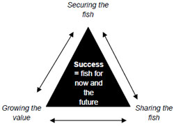
Figure 2. Fisheries Victoria vision of success.
Fisheries Victoria's vision and directions underpin its projects, policies and services. Fisheries Victoria's vision and strategic directions will be achieved with the cooperation and support of the community, industry and other government agencies. They will also be achieved within the legislative framework established by the Fisheries Act 1995 and Fisheries Regulations 1998.
Policy implementation tools
Fishery co-management arrangements
Co-management is an inclusive arrangement that brings industry, community and government together to participate in the management of a natural resource. It assists those involved by improving their collective understanding of individual stakeholder needs and aspirations and by identifying behavioural modifications that can increase the long term viability of the resource and, therefore, continued access to that resource by user groups.
The co-management of fisheries within Victoria is a process involving three entities. The first comprises the peak bodies as specified in the Act.
The second entity comprises the Fisheries Co- Management Council (FCC) and its expertisebased committees.
The third entity is the government agencies, including DPI of which Fisheries Victoria is a division.
The above co-management entities will ensure that the fisheries interests are appropriately acknowledged and represented during consultation processes regarding decisions that may impact on the fishery.
Fish stocking
The release or stocking of fish into inland waters is recognised as a fisheries management tool, to create, maintain and or enhance recreational fisheries.
DPI holds regional consultation meetings each year as a forum to discuss fish stocking, fish population surveys and other related recreational fisheries management issues.
Meetings include representatives from DPI, DSE, FCC, Water Management Authorities, Catchment Management Authorities, Victorian Recreational Fishing Peak Body (VRFish) and other stakeholders as required.
The meetings:
- review the current year's stocking plan and identify necessary modifications
- draft next year's stocking plan
- identify management questions to be answered by stock or catch assessments
- identify current fishery management issues.
Appendix 3 and 4 provides a list of fish stockings for the past six years (2001-2006) for the West Gippsland Region.
Translocation guidelines
Translocation of live aquatic organisms poses an ecological risk through the potential transmission of diseases, potential impacts on biodiversity from changes in genetic integrity, and the establishment of feral and or exotic populations (DPI 2003). The Victorian Government has developed Guidelines for Assessing Translocations of Live Aquatic Organisms in Victoria 2003 (Translocation Guidelines) (DPI 2003) to meet its obligations under the National Policy for the Translocation of Live Aquatic Organisms 1999 (MCFFA 1999). This policy requires all states in Australia to develop assessment measures for the translocation of aquatic organisms, including fish.
Stocking proposals in public and private waters will be assessed in accordance with the Translocation Guidelines, including any associated protocols approved by the Secretary, DPI.
To ensure that existing fish stocking programs, and new proposals which have manageable risks, can proceed without the need for individual risk assessments, protocols for public water stockings have now been developed. The Protocols for the Translocation of Fish in Victorian Inland Public Waters (Protocols) will ensure consistency with the Translocation Guidelines. Importantly, fish stocking proposals that meet the criteria outlined in the new protocols will not require an individual risk assessment.
In order to assess a proposed translocation, consideration is given to the potential hazards, the likelihood of the hazard occurring and consequences of that hazard. The risks that may arise as a result from translocations are outlined in the Guidelines. The risks are assessed in terms of:
- the likelihood and consequences of escape and or release
- the likelihood and consequences of survival
- the likelihood and consequences of establishment of a feral population.
More information on the Translocation Guidelines and associated Protocols can be obtained from the DPI website at www.depi.vic.gov.au/fishing.
Aboriginal stewardship
Customary fishing
Fisheries Victoria has been working with Indigenous community representatives, other Australian fisheries authorities and other fishing stakeholders to develop:
- a national set of principles and pathways to facilitate definition and lasting recognition of customary fishing practices
- increased opportunities for economic engagement of Indigenous communities in fisheries-related enterprises
- increased Indigenous participation in all aspects of fisheries use and management.
Following the development of a Victorian customary fishing policy, Fisheries Victoria may consider local actions to provide for customary fishing access in accordance with the agreed national set of principles.
Customary fishing practices by Indigenous Australians are not currently identified as a distinct type of fishing activity under Victorian fisheries legislation. Non-commercial fishing by Indigenous Australians is, therefore, treated as recreational fishing. The Fisheries Act 1995 provides for the issue of permits to facilitate the taking of fish for specified Indigenous cultural ceremonies or events. Unless exempted or holding a permit issued under the Fisheries Act 1995, Indigenous Australians are required to hold a recreational fishing licence when participating in recreational fishing activities.
Current controls on fishing
Recreational Fishing Licence
A Recreational Fishing Licence (RFL) is required for angling, bait pumping, hand collecting and all other forms of recreational fishing in Victorian public waters, including the West Gippsland Region. Some sectors of the community, including people under 18 or over 70 years of age, holders of a Victorian Seniors Card, and recipients of various age, disability or veterans benefits, are exempt from the need to hold this licence. Fish taken under a RFL cannot be sold.
Recreational fishing equipment
The Regulations define 'recreational fishing equipment' as including a rod and line, handline, dip/landing net, bait trap, spear gun (prohibited in inland waters), hand-held spear (prohibited in inland waters), bait pump, recreational bait net and recreational hoop net. Recreational use of any equipment not included in this definition is prohibited in all Victorian public waters. The maximum permitted dimensions of dip nets, bait traps, bait pumps, recreational bait nets and hoop nets are summarised in the Victorian Recreational Fishing Guide.
Inland waters
All lakes, impoundments, rivers, creeks and some estuaries of the West Gippsland Region are classified as 'inland waters' for the purposes of the Act.
The Act defines inland waters as (among other things) "any reservoir, dam, tank, channel or works for water storage or distribution vested in or under the control of the Crown or a public authority." It should be noted that most of these channels in the West Gippsland Region are managed by Southern Rural Water and that while possession of an RFL or an exemption entitles an individual to fish in these waters, it provides no authority to enter upon private land or land managed by Southern Rural Water to gain access to them. Where access is proposed, an angler must negotiate that access directly with the property owner or relevant land manager.
Size and catch limits
Legal minimum sizes, bag limits, and possession limits (in, on or next to fishing waters) for fin fish and invertebrate species for recreational fishing are prescribed in the Regulations or current Fisheries Notices, and are summarised in the Victorian Recreational Fishing Guide.
Some size and catch limits have been introduced as measures to protect fish stocks from unsustainable fishing pressure. Other controls exist for social or cultural reasons.
Requirement to land fish in whole or carcass form
For some fish species with high commercial market value and which are subject to size limits, there is a requirement to retain captured fish in whole or carcass form until after they have been landed (brought ashore), in order to ensure compliance with recreational size and catch limits. Fish species relevant to the WGFMP required to be landed in whole or carcass form include black bream and eels. In the case of scale fish, 'carcass' means a fish which has been scaled and gutted, but has not been headed or filleted. For further information on the requirement to land fish in whole or carcass form, please refer to the Victorian Recreational Fishing Guide.
Intertidal collection of shellfish
Shellfish and other invertebrate animals may be collected by hand or using an approved bait pump from most Victorian intertidal waters. Controls on intertidal collection of shellfish and other invertebrate animals are prescribed in the Regulations and are summarised in the Victorian Recreational Fishing Guide.
Salmonid regulations
Salmonid regulations are defined in the Fisheries Regulations. Changes to the Regulations with respect to the salmonid fishery made in 2006 included an additional 24 lakes in the schedule of waters managed as Family Fishing Lakes. With respect to the West Gippsland Fishery, the Regulations were altered to introduce new Family Fishing Lakes (Appendix 1) which will be intensively stocked to provide new fishing opportunities.
Recreational Fishing Licence Trust Account
Revenue from recreational fishing licence fees is spent to improve angling opportunities and fish habitats in Victoria. The Fisheries Revenue Allocation Committee (FRAC) which includes representatives of the recreational fishing sector, determines priorities and makes recommendations to the Minister responsible for fisheries on how the money should be spent. Every year the Victorian Government, through the Recreational Fish Licence Trust Account, disburses revenue derived from the sale of Recreational Fishing Licences to projects that will improve recreational fishing in
Victoria. On average $1.2 million of funding is granted to projects each year.
Grants are allocated to projects in one of four categories:
- recreational fishing access and facilities (but not recreational boating related infrastructure such as boat launching ramps)
- recreational fisheries' sustainability and habitat improvement including fish stocking
- recreational fisheries research
- recreational fisheries-related education, information and training. For further information on recreational licence funding, please refer to the DPI fisheries website at www.depi.vic.gov.au/fishing.
Management of non-fisheries issues
Climate change
Scientific opinion agrees that the threat posed by climate change will become more severe over the coming decades (IPCC 2007). The CSIRO has identified future climate projections for Victoria including reduced rainfall, increased temperatures, more frequent El Nino Southern Oscillation (ENSO) events, more heatwaves and fewer frosts and increased frequency of severe weather events, e.g. storms and high-risk bushfire days (DPI 2006b). Information on the likely impacts of climate change in the West Gippsland Region can be found at www.greenhouse.vic.gov.au. In summary, the future climate is expected to be drier and warmer with run-off expected to decrease by 2030.
Climate change is also likely to increase stress primarily on the heavily committed Latrobe, Thomson and Macalister systems. Lower flows and higher temperatures may also reduce water quality by creating a suitable environment for algal blooms and microbes (DSE 2004a).
Fisheries resources, such as trout and river blackfish which prefer cooler water temperatures, may experience reductions in available habitat and, therefore, suffer reduced viability in previously suitable areas. Reduced flows could affect river connectivity and reduce spawning cues for fish and have a deleterious effect on other aquatic organisms on which fisheries resources depend.
Climate change is identified as strategic priority for action in the Victorian Government's Growing Victoria Together (2005) policy statement. The
Victorian Greenhouse Strategy action plan outlines actions the Government is taking to reduce greenhouse gas emissions as well as to improve understanding of the impacts of climate change. DPI has developed an Action Agenda on Climate Change and Greenhouse which outlines adaptation strategies including improving understanding of the likely climate change impacts on inland fisheries in Victoria and using this information to assist fisheries management and inform recreational anglers (DPI 2006b).
Catchment and waterway management
The WGCMA was formed under the provisions of the Catchment and Land Protection Act 1994 and the Water Act 1999 and works with regional communities, industries and government stakeholders to coordinate the development of strategies for integrated management of land and water resources in West Gippsland.
The West Gippsland RCS (WGCMA 2004) and the West Gippsland RRHS (WGCMA 2005) identify valuable land, water and living natural resource assets, assess the condition of and identify threats to the maintenance of these assets (including identification of knowledge gaps), and provide directions on actions required to manage land (both public and private), water and biodiversity.
The WGCMA has developed a number of management action targets relevant to the WGFMP, including:
- an improvement of freshwater dependent focal species
- 30km of instream habitat rehabilitated (including large woody debris, removal of debris, grade control structures)
- seven fishing platforms constructed
- three reaches of aquatic weed control (focus on Spartina)
- reinstatement of flows to the Thomson River around the Horsehoe Bend Tunnel and the Morwell River around the piped section resulting in 179 km of fish passage opened up.
A number of risks were identified through the drafting of the RRHS (for example barriers to fish passage) but were not considered due to feasibility issues and high project costs (WGCMA 2005).
The Jack and Albert rivers riparian restoration project
The proposed Jack and Albert rivers riparian restoration (JARR) project strategic vision is to provide a coordinated approach to improve the environmental health and productivity of the Jack- Albert sub-catchment and the Nooramunga Marine and Coastal Park. The proposed project is being coordinated through the Yarram Yarram Landcare Network and is currently in its planning phase. It is proposed that the majority of onground work will be undertaken and owned by Landcare groups and individual landholders.
The proposed project is to be approached as a longterm investment in catchment and estuary health. If this project is successful in obtaining funding, Fisheries Victoria would be an advocacy agency.
Management of facilities for boat-based fishing
Management of installation, maintenance and boat launching facilities and jetties around the West Gippsland Fishery lies with many different agencies and may include local Government and Southern Rural Water.
Individuals or groups seeking clarification on the management of facilities for boat-based fishing or for information on grant programs, are encouraged to contact the relevant authority (DSE, local Government, Parks Victoria, Marine Safety Victoria) or VRFish.
The Gippsland Boating Coastal Action Plan (GBCAP) (GCB 2002) provides direction for the future management of safe and environmentally friendly boating throughout the Gippsland region. It also provides a framework for accommodating multiple uses and users of Gippsland waters.
Management of land-based angler access
Responsibility for the installation, maintenance and ongoing management of land-based access will be dependent on the official status of the land.
A VRFish policy Access for Recreational Fishing (VRFish 2004) has reviewed the issue of angler access to public land and made a number of recommendations to improve angler understanding of access issues across Victoria.
Individuals or groups seeking clarification on land access to specific parts of the West Gippsland Region for shore-based fishing should contact the relevant authority (DSE, local Government, Parks Victoria) or VRFish.
A number of access projects have been supported and funded by the Recreational Fishing Grant Program since 2004, including:
- $60,000 to enhance fishing facilities by replacing an existing boardwalk and four fishing platforms at the south bank of the Tarwin River, Tarwin Lower
- $21,375 to improve fish habitat by removing introduced vegetation, constructing fencing and installing signage at Apex Park, Morwell
- $11,500 to improve fish habitat by removing introduced vegetation, constructing fencing and installing signage at Primrose Park, Morwell
- $60,000 to construct an access track, vehicle parking, four fishing platforms, erect fencing and plant native vegetation at Springberg's Lane.
Many of the waterways in the West Gippsland Region are culturally significant to the Traditional Owners of the Country. Aboriginal communities across Victoria have developed a database of culturally significant sites and can provide advice to land managers on appropriate consideration of cultural heritage issues when improvements are being considered. Please refer to the 'Sites and cultural significance' section of this plan for further information.
Management and regulation of water
The amount and timing of water moving down rivers and into estuaries can have a major impact on the production of river and estuarine fish species. In addition to natural variation, water flows have changed as a result of extraction and diversions for irrigation, industry and domestic water needs.
The movement, regulation and delivery of water from rivers, lakes and groundwater supplies are overseen by a number of agencies within the West Gippsland Region.
Gippsland and Southern Rural Water (SRW) Authority manages irrigation and rural diversions. SRW is one of five rural water authorities in Victoria that provide services to farmers, graziers and growers through the management and control of irrigation water from rivers and groundwater aquifers.
Central Gippsland Region Water Authority manages urban water diversion.
Flow from the Thomson River (1,123,000 mega litres) is held in the Thomson Dam and diverted to Melbourne for urban water supply. Melbourne Water Corporation manages waters within the Thomson Reservoir. The Reservoir and all inflowing waters within 200 metres of the fully supply level is closed to fishing and public access. The Reservoir also releases irrigation water downstream to Cowwarr Weir for Gippsland.
The Macalister Irrigation District (MID) is a regulated gravity fed irrigation system which supplies more than 147,000 mega litres a year through 600 kilometres of open channels to irrigated holdings throughout central Gippsland.
The health of the Macalister and Thomson rivers has been degraded by a range of activities as a result of land management practices and reduced water flow.
The White Paper – Securing Our Water Future Together (a paper released to address water reform) outlines major changes to the way Victorians will use water. The Victorian Government through its "White Paper" has committed to improving the Thomson and Macalister rivers and the Gippsland Lakes by increasing environmental flows by 25,000 mega litres annually. The White Paper also identifies the WGCMA as the responsible authority for the development of an operational strategy for the management of the Environmental Water Reserve (EWR) for the Thomson and Macalister rivers. Until this strategy is in place, there is a cap on water allocations within Macalister, Thomson and Latrobe catchments.
Sustainable Water Strategy
Central Region Sustainable Water Strategy (SWS) is a plan to secure water supplies for homes, business, industry, agriculture and environment for the next fifty years. The community were invited to provide views and comments throughout the preparation of the document. Individuals and groups will continue to have an opportunity to have input throughout ongoing public consultation phases.
The SWS is responsive to changing water needs and includes actions to ensure there are sufficient supplies in the event that low inflows to reservoirs experienced over the past ten years continue. The SWS considers all water sources including rivers, reservoirs, aquifers (groundwater) as well as recycled water, storm water and sea water. The SWS includes the Thomson and Latrobe catchments.
The objectives of the SWS include:
- protecting and where necessary, improve the health of aquifers, rivers and estuaries
- making best use of water resources locally and throughout the region
- understand the implications of climate change and be prepared for a range of possible future scenarios.
- The WGCMA, DSE and various water management agencies have the responsibility to implement the outcomes of the SWS.
- A Gippsland SWS is proposed for 2008 and is anticipated to include all other Gippsland waters that were not included in the Central SWS.
Bulk Entitlements
The management of water found within regulated systems is through 'bulk entitlements' which are issued to urban and rural water authorities. The bulk entitlement identifies the volume of water allowed to be extracted, the rate of water extractions, the reliability of the supply and the required environmental flow.
Environmental Water Reserve
The Water (Resource Management) Act 2005 amends the Water Act 1989 and establishes the Environmental Water Reserve (EWR) as the legal share of water for the environment. The aim of the EWR is to provide a specific entitlement for the environment which can be used to help achieve environmental objectives. These objectives may include protection, or enhancement of fish populations.
The EWR may be maintained or enhanced in unregulated river catchments through the preparation of Stream Flow Management Plans or in regulated river catchments through either specific Environmental Entitlements (bulk entitlements for the environment) or conditions on existing Bulk Entitlements.
Environmental flow assessments & stream flow management plans
An environmental flow assessment is undertaken to gain an understanding of the environmental water requirements of a river. The FLOWS assessment tool provides an independent process for determining the environmental water requirements for a healthy river. The Our Water Our Future Victorian Government Action Plan (DSE 2004c) identified in the West Gippsland Region the Upper Latrobe, Tarra and Avon rivers as priority unregulated rivers for the provision of ecologically sustainable Environmental Water Reserves. This will be achieved through a range of mechanisms including, moving diverters to diverting water in winter when in most instances there will be less ecological damage, co-investing with farmers to assist them to build off-stream dams and harvest their water in winter, and/or the development of Stream Flow Management Plans. Stream Flow Management Plans (SFMPs) aim to provide a balanced and sustainable sharing between water users in unregulated catchments including the environment.
The plans are prepared for unregulated rivers with high environmental values and have been identified as flow stressed. The plans are developed in consultation with the community and relevant agencies to ensure an equitable share of water is allocated across all sectors (private, industry and the environment).
Management of water quality
Poor water quality, including increased sedimentation and turbidity primarily as a result from catchment related processes such as land clearing, industry and bushfires may have a significant impact on production and the overall health of fish stocks through an increase in pH, nutrients and dissolved oxygen levels. The Gippsland Water Quality Action Plan (WQAP) is the regional action plan addressing water quality in the West Gippsland Region. The WQAP identifies a range of priority management actions to address the causes of poor water quality across the West and East Gippsland regions.
Management of blue green algae/ dinoflagelletes in the West Gippsland Region
Ongoing effects of the drought in Victoria may lead to increased occurrences of algal blooms throughout the West Gippsland Region. Blue Rock Lake (Latrobe Basin), Lake Glenmaggie (Thomson Basin), Candowie, Lance Creek, Poowong, Korumburra No 1 and 3 and Leongatha 2, 3 & 4 Reservoirs (South Gippsland Basin) are facilities located in the West Gippsland Region that are subject to blue-green algal blooms.
Many species of micro-algae are naturally present in relatively small numbers in waterways. Waterway blooms are nearly always triggered by specific environmental conditions causing a proliferation of a particular species. Most blooms are not toxic; however, some may cause serious problems for water suppliers and users.
Favourable conditions for blooms may include:
- high nutrient levels, such as phosphorus and nitrogen are present in levels that support growth
- water is still or turbulence is minimal
- weather patterns are stable for an extended period with minimal wind
- warmer weather (some species also bloom in cooler weather).
In particular, blue-green algal (BGA) blooms may lead to an unpleasant appearance of water and pungent smells.
Some species of micro-algae produce toxins, making contact with affected water a potential danger to human and animal health. Such toxins may also accumulate in shellfish making them a potential risk to human health.
In high concentrations and in enclosed waters, fish may be directly affected through obstruction and irritation of gills. Fish deaths have also been known to occur as a result of anoxia caused by the rapid decomposition of the algal cells following a bloom or oxygen consumption by phytoplankton at night.
DSE is the Regional Convening Agency for the management of BGA blooms within the Thomson and Latrobe River Basins. Management of algal blooms in these river basins (excluding the South Gippsland River Basin) are currently being reviewed, with DSE leading a process to update the existing framework for algal bloom management within the Region.
Southern Rural Water is currently responsible for management of algal outbreaks in storages it manages in the Latrobe and Thomson River basins including Blue Rock Lake, Lake Narracan, Lake Glenmaggie and Cowwarr Weir. This responsibility also extends to its water supply network in the Macalister Irrigation District and the Latrobe, Thomson, and Macalister rivers.
It is proposed that the revised management framework will identify appropriate Local Water Managers for other waterways not currently specified in the plan but that are known to experience BGA blooms.
South Gippsland Water is responsible for management of algal outbreaks in potable water storages in the South Gippsland Basin and monitors the Tarwin (East and West branch), Agnes and Tarra rivers and Deep Creek.
Management responsibilities of local Government
The West Gippsland Region includes municipalities of Latrobe City, and parts of Wellington, Baw Baw, South Gippsland, Bass Coast and sparsely populated areas of East Gippsland and Delatite.
Local government manages a range of issues that can impact fisheries resources and recreational fishing opportunities. Applications for planning permits, review of planning overlays and zones and the maintenance of roads and tracks can all have an impact on angler access to fisheries resources, and the habitats that support these resources. Local government also has an important role in implementing environmental programs (eg weed management) and engaging community groups in natural resource management projects.
Management of aquatic pest plant and animals
The introduction and spread of a number of introduced plants and animals in Victorian estuaries has been listed as a 'Potentially Threatening Process' under the provisions of the Flora and Fauna Guarantee Act 1998. This Act requires that Action Statements be developed describing how these threats are to be addressed in Victoria.
Marine pest emergency arrangements known as the "Interim Victorian Protocol for Managing Exotic Marine Organism Incursions" currently form the basis for responding to introductions and incursions of marine pests.
Spartina (Spartina sp)
Spartina was first introduced to the West Gippsland area in the 1940s and again in the 1960s to aid in land reclamation, stabilise intertidal mudflats, increase grazing land at low tide and assist with the prevention of coastal erosion (Rash et al. 1996). Spartina is found in the estuarine sections of the following rivers:
- Tarwin
- Agnes
- Albert
- Franklin.
The community raised concern over narrowing and shallowing of channels; possible adverse impacts of Spartina invasion on mangrove/saltmarsh communities; and possible denial of intertidal habitat to fish stocks.
Specific management actions to control the spread of Spartina, together with the relevant management agencies in these estuarine environments can be found in the West Gippsland RRHS and the Gippsland Estuaries Coastal Action Plan (GCB 2006)
Carp (Cyprinus carpio)
Carp is one of the world's most common freshwater fish and has all the characteristics of a species that is invasive and opportunistic (Murray Darling Basin Commission 2000). It is a native of Asia and was spread throughout the world including Australia with the earliest records indicating the species was introduced to Victorian waters in the late 1850s probably due to the desire of some colonists to imitate a European environment (Koehn et al. 2000).
In the West Gippsland Region, carp have become established in many rivers and their associated habitats including wetlands, billabongs, backwaters, anabranches, impoundments and some estuarine and coastal lakes including the Gippsland Lakes via Lake Wellington (Koehn et al. 2000).
Carp control plans as identified in the RRHS are likely to be carried out on a sub-catchment basis. The WGCMA has undertaken some preliminary work on identifying potential management options (including daughterless carp, carp exclusion devices and carp traps), although application of these techniques have yet to be applied to any particular area within the West Gippsland Region (except for habitat restoration and improved river management).
DPI has invested $315,000 since 2006 to support ongoing research into carp management and control through joint projects established by the 'Invasive Animals Cooperative Research Centre' (IACRC).
Research has focused on sustainable medium and long-term control of carp and other priority freshwater pest fish species. Projects supported by DPI include:
- a review of national and state policy on the use of genetic technologies such as 'daughterless' carp
- an investigation of fish-specific biocides and possible delivery options
- identification and isolation of natural environmental attractants for common carp control
- development of software to simulate the effectiveness of possible carp management strategies such as trapping, predation and pheromone attractants.
The National Management Strategy for Carp Control (Murray Darling Basin Commission 2000) is the key policy document that describes state responsibilities and aims to:
- prevent the spread of carp
- reduce the impacts of carp to acceptable levels
- promote environmentally and socially acceptable application of carp control programs
- improve community understanding of the impacts of carp and the management strategies
- promote the cost efficient use of public resources in carp eradication and control programs.
The suggested implementation of the national carp strategy uses a risk assessment model that is also the framework for decisions in the WGCMA RRHS. Carp control may occur where carp damage threatens high value assets (for example, native fish populations, recreational fishing).
At a state level, the Victorian Pest Management – A Framework for Action (VPMF) (DNRE 2002b) sets out the guiding principles of how pests will be managed in Victoria. The VPMF provides a mechanism for considering terrestrial and aquatic (freshwater and marine) weeds, and vertebrate and invertebrate pest management in Victoria.
Integrated management of Gippsland estuaries
Coastal Action Plans (CAPs) are developed under the provisions of the Coastal Management Act 1995 to address coastal issues and implement the objectives of the Victorian Coastal Strategy at a regional level.
The Gippsland Coastal Board (GCB), in partnership with the West and East Gippsland CMAs, has developed a Gippsland Estuaries CAP. The Plan was formally adopted in November 2006. The Gippsland Estuaries CAP identifies six themes which form the basis of the estuary planning and management framework including:
- protection of natural values
- conservation of Indigenous cultural and heritage values
- improving water quality
- management of estuarine entrances
- guiding development and land use
- sustainable management of estuary uses and activities.
The Gippsland Estuaries CAP aims to provide a strategic framework for the future use, development and management of the major riverine estuaries, within the Gippsland region. It is expected that implementing the Gippsland Estuaries CAP will help to maintain or enhance aquatic and terrestrial environments and biodiversity, while maximising social and economic benefits from the use of estuaries.
Artificial entrance openings
Many rivers along the Victorian coast open intermittently to the sea. They may close naturally when currents deposit sand at the entrance. This often coincides with periods of low freshwater flow. When the entrance closes, the duration of closure may influence both the physiochemical conditions (for example, dissolved oxygen, salinity and water temperature) and also may impact on the kinds of fish species found within the estuary.
In the past, the entrance at the Powlett River has been opened artificially when high water levels threatened to inundate infrastructure and land surrounding the river. At the time of writing this Plan, Parks Victoria together with community members and other agencies including the WGCMA, have the responsibility for any decision making regarding artificial entrance openings.
At a statewide level, a Steering Committee has been formed to prepare an Estuary Entrance Management Support System (EEMSS). The EEMSS will assist managers to decide whether or not to artificially open an estuary entrance and under what conditions. It is anticipated that the EEMSS will be applicable for Gippsland estuaries, including the Powlett River and Merrimans Creek. Experts in relevant disciplines (including fisheries) and the community will be engaged to ensure that consideration is given to all possible environmental, social and economic impacts and benefits associated with an opening.
A number of options for management of entrance openings are currently being considered at a regional level and are expected to be finalised shortly.
Preparation of the West Gippsland Fishery Management Plan
Steering committee
The WGFMP was prepared by Fisheries Victoria, assisted by Steering Committee consisting an independent chair and representatives from key stakeholders including VRFish, the FCC, local Government, the West Gippsland Catchment Management Authority, DSE, Southern Rural Water and Indigenous interests.
The role of the Steering Committee was to advise the Executive Director, Fisheries Victoria, DPI, on the preparation of the WGFMP consistent with the requirements of the Act and the Ministerial guidelines, and to assess public submissions from community consultation on the draft WGFMP.
A list of the stakeholder representatives are provided in Appendix 5.
Planning process
The process for developing the management plan includes the following steps:
- Conducting public meetings to identify recreational fishing values and issues across the region.
- Holding steering committee meetings to evaluate issues and options for addressing those issues identified through public meetings and the issues identification workshop.
- Preparing a draft management plan addressing the issues identified and developing the options for dealing with the issues.
- Providing the public and stakeholders with an opportunity to comment on the draft management plan.
- Preparing final management plan following stakeholder submissions.
- Seeking Ministerial approval for the declaration of the management plan in the Victorian Government Gazette.
Public consultation
The first step in the preparation of the WGFMP was to seek the views and comments of recreational fishers and other community interests regarding the values and issues associated with fishing in the West Gippsland Region.
In October/November 2006, public meetings were held at Sale, Traralgon, Ellinbank and Leongatha to canvass views and comments of the community. Recreational fishers and members could also provide written submissions by 24 November 2006. Information was sought to determine:
- the species of fish most important for recreational fishing across the West Gippsland Region
- factors the community believes are limiting their ability to target or catch these species
- opportunities to enhance recreational fishing across the West Gippsland Region
- any other issues relevant to the West Gippsland Region.
Thirty-two verbal and written submissions were received from this round of consultation, providing a range of views on values and issues associated with the West Gippsland Region. This information helped to guide the drafting of the WGFMP so that it had a strong focus on addressing fishing-related issues that matter to both recreational fishers and the local community.
A summary of the key issues raised can be found in Appendix 6.
West Gippsland Fishery Management Plan
Scope of plan
The overall purpose of the WGFMP is to formalise management arrangements for the West Gippsland Region in accordance with the provisions of the Act, the Ministerial guidelines and the national Fisheries ESD Reporting Framework.
To this end the WGFMP specifies goals, objectives, strategies and actions for management of fisheries resources across the West Gippsland Region.
The WGFMP builds on community feedback and identifies the most valued recreational fishing assets in the region and describes the highest priority strategies and actions to mitigate issues/risks that could impact on these fishing assets.
The WGFMP also identifies recommended actions by stakeholders and other management agencies to ensure that processes for management of other values and uses of the region's waterways include identification and minimisation of potential adverse impacts on fish habitat and fisheries.
The WGFMP contains a section describing research and monitoring information needed to address the identified management objectives and performance indicators; a section outlining compliance with fishing controls in the region; and a section describing implementation and future review processes.
Requirements of the Fisheries Act 1995
The Act stipulates that a fishery management plan must:
- define the fishery to which it relates
- be consistent with the objectives of the Fisheries Act 1995 and with any Ministerial guidelines issued with respect to the preparation of the management plan
- include the management objectives of the management plan
- specify the management tools and any other measures to be used to achieve the objectives of the plan
- include guidelines for the criteria to be used in respect of the issue of licences and permits and in respect of the renewal, variation or transfer of licences
- as far as is known, identify critical components of the ecosystem relevant to the plan and current or potential threats to those components, and existing or proposed preventative measures
- specify performance indicators, targets and monitoring methods
- as far as relevant and practicable, identify any other biological, ecological, social and economic factors relevant to the fishery covered by the plan, including its current status, human uses and economic value; measures to minimise its impact on nontarget species and the environment; research needs and priorities; the resources required to implement the plan
The Act also indicates that each fishery management plan may:
- specify the manner in which fishing capacity is to be measured and the fishing capacity so measured
- specify the duration of the management plan
- specify procedures and conditions for review of the plan
- include any other relevant matters.
Additional direction on the development of the WGFMP has been provided by the gazettal of Ministerial guidelines on 5 October 2006 (see Appendix 7).
Definition of the fishery
The West Gippsland Fishery is hereby defined as all inland waterways (lakes and rivers) in the Thomson, South Gippsland and Latrobe basins. The Fishery does not include Shallow Inlet, Anderson Inlet, Corner Inlet/Nooramunga and the Gippsland Lakes (including Lake Wellington).
Duration of the plan
The WGFMP provides the basis for the management of specified waters within the West Gippsland Region for a period of 5 years unless established fishery monitoring and assessment programs indicate a need for a review prior to that time.
Review of the plan
Review of the WGFMP and preparation of a new WGFMP will commence twelve months prior to the schedule expiry of the WGFMP. The review will examine all aspects of fisheries management against the defined goals, performance indicators and reference points, and will examine the need for new or amended objectives in light of monitoring and research information obtained.
Should there be a need for the Minister to amend the WGFMP prior to its review, notice of this intention will be published in the Victorian Government Gazette and there will be formal consultation with stakeholder groups.
Implementation of the plan
The WGFMP provides direction for recreational fisheries management for the West Gippsland Fishery.
Initially, most fishery management measures for the West Gippsland Fishery will remain unchanged with a focus on reviewing appropriate resource allocation, establishing programs to monitor the status of key recreational species and identifying key environmental threats to fisheries resources.
If information from these programs indicates a need to alter fishery management arrangements in the future to ensure sustainable use or to meet changing demands for recreational fishing opportunities, then changes will be considered in consultation with stakeholders.
Any proposed changes to fisheries regulations may be subject to a Regulatory Impact Statement (RIS) process under the provisions of the Subordinate Legislation Act 1994, which includes extensive consultation with stakeholders.
The WGFMP will come into effect following a declaration by the Minister via a notice in the Government Gazette and will be made available to the public through the Internet and as a published document.
The West Gippsland Fishery Reference Group
The West Gippsland Fishery Reference Group will be established to work with DPI to deliver the desired management outcomes for the West Gippsland Fishery. It is proposed that the West Gippsland Fishery Reference Group include representatives from recreational fishers (VRFish), public land managers (WGCMA), water management authorities (Southern Rural Water) and Indigenous interests. Other groups or individuals may be engaged as required.
The role of the Reference Group is to advise the Executive Director, Fisheries Victoria, DPI with respect to the coordination of activities and projects in support of the WGFMP actions, strategies and objectives, including monitoring the implementation of the WGFMP. The Reference Group will also facilitate partnerships with other agencies to develop programs, and review the outcomes of research and provide recommendations on future research directions.
Fisheries Victoria will establish the Reference Group within the first twelve months of declaring the WGFMP. Terms of reference to guide the Reference Group will be issued by the Executive Director, Fisheries Victoria, DPI.
Ongoing implementation of the WGFMP will require action by DPI in conjunction with the Reference Group and other stakeholders to establish the required fishery monitoring and research programs, to carry out day-to-day management activities, and to ensure compliance with fishery management arrangements.
Key actions required to facilitate implementation of this plan are summarised in Table 1.
An annual progress report will be prepared by Fisheries Victoria on the implementation of the WGFMP and will provide details of progress against key performance indicators. Annual reports will be available on DPI website at www.depi.vic.gov.au/fishing/.
Costs of implementation
Costs of establishing the required fishery monitoring and research programs, and potential funding sources, are described in Table 2 in the 'Research and monitoring' section of the WGFMP. Costs for implementation of fisheries compliance activities across the West Gippsland Fishery will be met within the DPI Fisheries Program budget allocation.
Management goal and objectives
The following broad goal and objectives apply to management of fishing activities in the West Gippsland Region.
Goal
The goal of the WGFMP is to manage fisheries resources of the inland component within the West Gippsland Region in accordance with the principles of ESD. This includes identifying the habitats and aquatic environments on which fisheries resources depend, and enhancing the social and economic benefits to all Victorians.
Objectives
- Biological – To conserve and ensure the sustainable use of key fish stocks across the West Gippsland Fishery.
- Social – To maintain and where possible enhance recreational fishing opportunities across the West Gippsland Fishery.
- Environmental – To promote protection and where possible enhancement of the habitats and environments which are essential for production or maintenance of fisheries resources across the West Gippsland Fishery.
- Governance – To achieve maximum community participation, understanding and support for the management of fisheries resources across the West Gippsland Fishery.
Performance indicators
Performance indicators are provided for actions that Fisheries Victoria has responsibility for implementing. These indicators provide a means of tracking progress on an ongoing basis.
As part of the annual reporting against the WGFMP, management actions and performance indicators may be further refined using data from monitoring programs and surveys.
Performance indicators are not provided for actions that other agencies are responsible for implementing.
Targets
Targets provide a longer-term measure for the objectives of the WGFMP. Targets should be achieved through the successful implementation of the WGFMP.
Identification and prioritisation of strategies
During the development of the WGFMP, consideration was given to the biological, environmental, social and governance components of the fishery in accordance with the principles of ESD.
Ten strategies have been identified to address the goal of managing fisheries resources in the West Gippsland Fishery in accordance with the principles of ESD. The strategies were identified as a result of the planning process outlined.
The ten strategies fit into three broad themes reflecting the biological, social and environmental objectives of the WGFMP. The governance objective is addressed through the planning process, the implementation and reporting against the WGFMP.
The themes are presented under the following chapters in the WGFMP: Sustainable Use of Fish Resources (Biological); Recreational Fishing Opportunities and Issues Affecting Recreational Fishing (Social), and Maintenance of Fish Habitat (Environmental).
More detailed accounts of the strategies, management actions, performance indicators and schedules needed to address each of these objectives are provided in the following sections and are summarised in Table 1.
Some of the issues raised during the development of the WGFMP cannot be directly dealt with in accordance with fisheries legislation. For these issues, the WGFMP attempts to identify other processes whereby recreational fishing interests can ensure their concerns are addressed.
Further information
For further information on this management plan or to comment on its implementation or recreational fishing in general, contact the Department of Primary Industries Customer Service Centre telephone 136 186 or visit the DPI website.
For further information on the activities of VRFish, visit the VRFish website at www.vrfish.com.au.
Sustainable use of fishery resources
Strategy 1 – Monitor catch rates and size composition of key recreational target fish species
Waters of the West Gippsland Region support fisheries that are relatively small in comparison with other recreational and commercial fisheries under Victorian jurisdiction.
Objectives, strategies and performance indicators for sustainable use of West Gippsland fish resources will therefore need to be achievable and cost effective given limited resources for fishery resources monitoring, assessment and management.
Ensuring sustainable recreational fishing requires knowledge of general fishery trends and fluctuations in the abundance and size composition of key target fish populations. Further work also needs to be undertaken to determine the relationship between fishing pressure in the larger bays and inlets (Corner Inlet and Gippsland Lakes) and the inflowing rivers within the boundaries of the West Gippsland Region.
This information will assist resource managers to make 'adaptive' management decisions to ensure recreational fishing pressure is maintained at sustainable levels.
Establishment of ongoing monitoring of recreational fishing activities to collect information on catch rates and size composition of key recreational target species is therefore a key focus of the WGFMP. The most cost effective method for collecting this type of information is a targeted recreational fisher research diary program.
Ongoing recreational fisher research diary programs will provide a time series of data on catch rates and size composition for key recreational fishery species and therefore an indication of fluctuations in year class abundance and recruitment. Information on pre-recruit (smaller than the legal size) as well as recruited fish will assist fishery managers by providing the capacity to predict changes in fishery conditions and to plan appropriate management responses.
The ongoing program will rely on experienced and highly skilled volunteer anglers undertaking research angling trips targeting specific fish species in accordance with prescribed methods. Hook size, bait and fishing locations are varied within the identified waters to ensure a representative sample of the stock of a targeted species in the waterway is sampled. The program collects information on abundance, length and age (through the removal and aging of otoliths) of the target species.
Recent anecdotal reports and public consultation indicated that the following species are the most popular native target species in the waters of the West Gippsland Region:
- Gippsland spiny freshwater crayfish
- estuary perch
- Australian bass
- black bream
- river blackfish.
For native fish in the region, there has been no systematic monitoring of recreational fishing pressure or fish stocks. The research angler diary monitoring program will initially concentrate on the three most popular native species: estuary perch; Australian bass and Gippsland spiny freshwater crayfish. Other species including brown and rainbow trout will be monitored through Strategy 2.
Fisheries Victoria recognises that rainbow and brown trout are a popular fishery species in the West Gippsland Region. Survey work undertaken as a result of regional consultation meeting outcomes since 2000 in both rivers and impoundments (see Appendix 2) indicates that wild trout populations are self sustaining in the West Gippsland Region and that stocking regimes have been generally accepted by anglers as successful. It is anticipated that Fisheries Victoria will continue its research and monitoring programs for brown and rainbow trout as a part of the regional consultation meeting process and a new angler diary program including trout will also be established as a part of Strategy 2.
Gippsland spiny freshwater crayfish
Gippsland spiny freshwater crayfish is a priority for monitoring as this species has limited geographic distribution and its abundance may also be affected by habitat alteration and degradation. Anecdotal reports from regional Fisheries Victoria staff and public consultation suggest that this species may also be affected by high levels of fishing pressure.
Currently, there are limited data on the levels of recreational take of this species and monitoring will improve understanding of the stock status and assist in ascertaining the sustainability of the species.
If the research diary program for Gippsland spiny freshwater crayfish is not feasible, fisheryindependent surveys of this species may be required.
Estuary perch & Australian bass
Estuary perch and Australian bass are both popular recreational native fishery species in the West Gippsland Region. Estuary perch are known to be caught from the Powlett, Avon, Tarra, Latrobe, Albert and Agnes rivers as well as Merrimans, Screw and Pound creeks, while anecdotal evidence suggests that Australian bass are regularly caught from the Macalister, Avon and Perry rivers.
Estuary perch and Australian bass normally spend their entire life cycle in a system and consequently, their abundance is likely to be determined almost entirely by environmental and or fishing factors in these systems.
The abundance of successive year classes of estuary perch and Australian bass in Victorian estuaries is known to vary substantially, probably as a result of fluctuating habitat/environmental conditions determining the success of spawning and the survival of young fish. Abundance can be monitored as they grow and enter the fishery.
Knowledge of recruitment patterns can be used to adapt fishery management arrangements so that full advantage is taken of periods of strong recruitment while avoiding excessive fishing pressure during periods of poor recruitment.
The popularity of these species and the limited data currently available means that the proposed monitoring program will be valuable to fisheries managers to enable them to make informed management decisions.
Black bream & river blackfish
Black bream populations and fisheries are being monitored and assessed in a number of larger estuaries across Victoria including the Hopkins River estuary (DPI 2006c), the Glenelg River estuary (DPI 2006c), the Gippsland Lakes, Lake Tyers (DPI 2007) and Mallacoota Inlet (DPI 2006d). The information obtained from these programs will assist in interpreting black bream fishery information obtained from the West Gippsland Region.
Collection of diary information on recreational fishing for river blackfish and black bream will rely on identification of fishers who target these species and are willing to join the angler diary program. River blackfish are well distributed across Victoria's rivers and lakes and fishing pressure targeting this species is thought to be generally low. The greatest threats to river blackfish are likely to be from non-fishing impacts like siltation in rivers and streams and removal of habitat (DPI 2003). River blackfish will continue to be managed at a statewide level.
Actions
Fisheries Victoria to develop a recreational fisher research diarist program to provide information on catch rates and size composition of estuary perch, Australian bass, Gippsland spiny freshwater crayfish and other significant target fish species in the waters of the West Gippsland Region, subject to available funding.
Fisheries Victoria to establish fishery independent surveys of Gippsland spiny freshwater crayfish if required, and if funding is available.
Where information collected from recreational fisher diary programs indicates a need to review recreational fishery management arrangements in order to ensure the impacts of fishing are sustainable, Fisheries Victoria will evaluate possible fishery management actions in consultation with stakeholders.
Performance indicator
Establishment of cost effective programs in the West Gippsland Region to monitor recreational fishing trends and determine patterns of recruitment of estuary perch, Australian bass and Gippsland spiny freshwater crayfish to the fisheries.
Targets
The recreational harvest of key target species is sustainably managed in response to information collected from monitoring programs.
Independent survey for spiny crayfish undertaken if required.
Fisheries management arrangements are adjusted to respond to angling pressure.
Strategy 2 - Monitor catch composition and trends for other fishery species
More than 17 native and introduced species have been reported from recreational catches in the waters of the West Gippsland Region.
Trout
Trout is an icon species in the West Gippsland Region and is a popular recreational angling species. Trout is stocked in several impoundments in the West Gippsland Region, but in many rivers and streams, trout fisheries are based on selfsustaining wild populations.
Angler catch and effort records can provide information on fishery trends for fishery management. During the mid 1990s anglers provided valuable information on fishing catch and effort and the proportion of stocked brown and rainbow trout in catches from a number of rivers and impoundments in the West Gippsland Region. More recently in other parts of Victoria, angler logbook programs have provided similar information. This monitoring has enabled fishery managers to assess species composition and ongoing fishery trends and adapt management responses where appropriate.
Other species
Anecdotal evidence from public consultation suggested that other species such as tupong, eels, mullet, luderick, carp and mulloway were caught occasionally as by-catch during fishing activities aimed at key recreational fish species.
The most cost effective method to monitor the species composition of recreational catches, and to detect changes in catch levels or targeting preferences, is to establish an ongoing general angler logbook program for waters of the West Gippsland Region.
If information collected from the general angler logbook program, together with supplementary data from the research angler diary program, indicates there is a significant change in catches of any minor species, or a shift in the preferred target species, then a closer investigation of the change in trend or review of fisheries management arrangements may be justified.
Actions
Fisheries Victoria to establish an ongoing recreational fishing general logbook program for the waters of the West Gippsland Region to collect information on catch composition and to detect changes in catch or targeting trends for a range of species, subject to funding.
If information from the general logbook program indicates changing fishery trends, Fisheries Victoria, in conjunction with stakeholders, to assess the need for further investigation and or to review the adequacy of existing fishery management arrangements.
Performance indicator
Establishment of a cost effective recreational fishing general angler logbook program for waters of the West Gippsland Region to determine species composition of catches and allow ongoing assessment of fishery trends.
Fishery management arrangements are adjusted to respond to angling pressure.
Target
The recreational harvest of key target species is sustainably managed in response to information collected from monitoring programs.
Recreational fishing opportunities
Strategy 3 – Classify waters within the West Gippsland Fishery
In 2006, the State Government recognised the preparation of a stream classification model (SCM) to promote native, salmonid (trout and salmon) and mixed fishery waters. The SCM will aim to provide clarity for recreational anglers wishing to participate in fishing activities in specified waters as outlined by the SCM.
Fisheries Victoria recognises that the SCM may require flexibility to account for boundaries which may alter seasonally due to fluctuations in river flows and water levels and other habitat conditions.
Actions
VRFish to lead the preparation of a SCM for the waters of the West Gippsland Fishery to define the waters to be recognised as Native, Mixed or Salmonid fisheries.
Management decisions will recognise the SCM and broader government policy.
Strategy 4 – Maintain stockenhanced salmonid fisheries in the West Gippsland Region
The maintenance of stock-enhanced fisheries generates important social and economic benefits.
To enhance the recreational fishing value of the West Gippsland Fishery, salmonid fish species are stocked into various impoundments and rivers by Fisheries Victoria as determined by representatives at the regional consultation meetings.
Some of the most productive and highly rated angling waters in the West Gippsland catchment are Blue Rock and Glenmaggie lakes and the Macalister River. The success of the fisheries in these waters is dependent upon a range of factors such as water level, water temperature and dissolved oxygen levels, combined with appropriate levels of stocking to provide rapid fish growth and angling opportunities. The abundance of available food is also a critical factor in determining the growth rate and condition of salmonids species.
Overstocking in impoundments can have a number of implications for both the fishery and the supporting ecosystem. The implications of introducing too many salmonids may include a decline in the growth and condition of the population and a decline in the natural populations of invertebrates and prey fish.
Stocking of impoundments is conducted in accordance with the Translocation Guidelines and complies with the criteria specified in Protocols. The current stocking regime aims to strike a balance between the carrying capacity of an impoundment and the social value that stocked fisheries provide. The process also considers possible implications for any threatened or endangered species where appropriate.
Overstocking may also stimulate phytoplankton by shunting nutrients such as phosphorus from the littoral to the pelagic zone. Management of the West Gippsland salmonid fishery therefore requires consideration of seasonal environmental conditions with the aim of stocking to a level which maintains an ecological equilibrium for the growth and development of salmonids along with maintenance of the ecosystem on which the fishery relies.
Action
Fisheries Victoria to continue to stock fish in support of recreational fishing in suitable waters as agreed at annual regional consultation meetings and where consistent with the Translocation Guidelines.
Performance indicators
Stocking programs are consistent with the Translocation Guidelines, and the Protocols where appropriate, and outcomes of the regional consultation meetings.
Existing salmonid fisheries are supported subject to environmental constraints.
Target
Existing brown and rainbow trout fisheries are supported subject to environmental and translocation constraints and as agreed to at annual regional consultation meetings.
Strategy 5 – Provide new fishing opportunities in the West Gippsland Region
In early 2002, 12,450 Australian bass were released into Lake Glenmaggie. A further 59,350 Australian bass were released into Blue Rock Lake, Lake Glenmaggie and the Macalister River in 2003. Reliable Australian bass production has since been problematic.
When the capacity to produce Australian bass within Victoria has been established, a stocking program in the Snowy River will be developed. Ultimately, the stocking program will be expanded to include waterways in the Gippsland Lakes catchment (including waters in the West Gippsland Region).
The production of fish will be supported by a genetic program to preserve the genetic integrity of existing stocks.
Monitoring programs to investigate the returns of Australian bass to anglers will be considered as a part of this strategy. Information on catch and effort as well as size/age data can be collected through the recruitment of research anglers in waters (particularly in impoundments) throughout the West Gippsland Region.
Actions
Fisheries Victoria to work in partnership with stakeholders to establish a quality assured Australian bass breeding program in Victoria.
Subject to environmental and biological constraints and production success, Australian bass stocking will commence in waters within the West Gippsland Region as identified though the regional consultation meetings.
Fisheries Victoria to ensure that any proposals for stocking programs are consistent with the Translocation Guidelines and associated Protocols.
Fisheries Victoria to establish a cost effective monitoring program to investigate ongoing angler returns, subject to funding.
Performance indicator
Australian bass are stocked in West Gippsland waters subject to environmental and biological constraints and availability.
Fishery management arrangements are adjusted to respond to angling pressure.
Targets
Australian bass stocking programs implemented in selected impoundments in the West Gippsland Region.
Fisheries management employs adaptive fishing management arrangements where appropriate as a result of monitoring programs.
Strategy 6 – Support the establishment of the Go Fishing in Victoria initiative at Hyland Lake
The Victorian State Government has committed $3.2 million over four years (2006/2007 until 2009/2010) to the Go Fishing in Victoria initiative, which aims to improve recreational fishing facilities and infrastructure, as well as promote opportunities for fishing as a family activity. Recognising that recreational fishing is a major social and economic contributor to Victorian communities, the Government aims to boost participation. As part of the initiative, Hyland Lake, located near Churchill, has been chosen as a Premier Lake Premier Lakes will feature all ability access, family friendly facilities such as toilets, BBQs, playground equipment and picnic tables and will also host family fishing events as well as the second and third term school holiday periods.
Stocking of Premier rainbow trout at least four times a year (subject to suitable water conditions) in Hyland Lake is planned to commence in 2008. These stockings will coincide with Family Fishing Events which will provide families the opportunity to experience recreational fishing, perhaps for the first time.
Some information on angler satisfaction will be available from evaluation data collected at Go Fishing in Victoria events. This information will be used to determine whether the profile of fishing, as a family activity, has increased.
It is important that at the end of the Government initiative these programs are continued by the recreational fishing community. A process for transitioning the program to local recreational fishing groups, with stockings maintained through the regional consultation meetings needs to be considered.
Actions
Fisheries Victoria to continue to promote the use of Hyland Lake as a Premier Lake.
Fisheries Victoria to conduct follow up evaluations (e.g. at six months) on participants that attend Family Fishing events at Hyland Lake to provide some data on angler revisitation rates and overall satisfaction with the fishery.
Fisheries Victoria to work with VRFish and local stakeholders to develop arrangements to continue the program beyond the Government initiative.
Performance indicators
Premier rainbow trout are stocked in Hyland Lake subject to suitable water conditions. Recreational anglers retain an interest in recreational fishing.
The program continues beyond the Government's initiative.
Target
Demonstration that anglers retain an interest in recreational fishing activities as a result of the Go Fishing in Victoria initiative.
Strategy 7 – Identify and encourage responsible recreational fishing behaviour
Access to Victoria's fish stocks for recreational purposes brings with it a responsibility to act in an acceptable manner and develop stewardship for the resource. To support Fisheries Victoria in meeting this responsibility, VRFish developed the Victorian Recreational Fishing Code of Conduct. This document outlines what recreational fishers deem to be acceptable behaviour.
Many regulations applying to recreational fishing in Victorian waters have been introduced at the request of recreational fishers for ethical or cultural reasons, including concerns about possible future stock conservation issues, rather than because of a scientifically identified need to protect fish stocks from excessive fishing pressure. A number of daily bag and possession limits have been introduced or amended to define a 'reasonable' daily take for personal use, and some size limits have been introduced to define minimum acceptable sizes of fish for human consumption. Regulations introduced or amended for these reasons have, in nearly all cases, been applied uniformly to all Victorian waters.
Preliminary information obtained during public consultation on the development of the WGFMP indicated that many recreational fishers were generally satisfied with existing controls on recreational fishing within the West Gippsland
Region. A number of submissions called for changes to catch limits and or size limits for particular species, including estuary perch, trout and luderick for cultural or ethical reasons. Reasons included concern about possible future stock conservation issues, defining a 'reasonable' number of fish to take for personal use, or defining the minimum size of a particular type of fish that is acceptable for eating purposes.
Victorian recreational fishing catch limits were revised in 2000 after a four year review process that included extensive consultation with the VRFish and several rounds of public comment. Proposed catch limits including estuary perch were established on the basis of what the majority of Victorian recreational fishers considered to be reasonable, desirable or acceptable.
More recently, recreational fisheries have made further requests for statewide reviews of size or catch limits for particular species. These requests will be considered in consultation with VRFish and the recreational fishing community during a review process initiated in 2006. All information obtained from public consultation has been provided to the review panel for its consideration. The WGFMP does not contain any recommendations for changes to recreational catch or size limits that are proposed for ethical or cultural reasons.
The National Strategy for the Survival of Released Line Caught Fish is an initiative of the Fisheries Research and Development Corporation (FRDC) in association with Recfish Australia and the Australian National Sportsfishing Association (ANSA).
The main aim of this strategy is to improve the survival rate of fish which have been caught by hook and line and released through a better understanding of the effects of fishing catch and release on the survival of released fish, and through adoption of "best practices" in handling released fish. Further information on the National Strategy for the Survival of Released Live Caught Fish, can be obtained from the FRDC website.
Action
VRFish to facilitate the distribution of the Victorian Recreational Fishing Code of Conduct through through appropriate outlets in the region and by including it in DPI's Victorian Recreational Fishing Guide.
Maintenance of fish habitat
Sustainable use of fishery resources is dependant not only on controlling the impacts of fishing on fish stocks, but also on the integrity of the aquatic habitats and the ecological processes that support the fishery. This is recognised in the move to an EBFM approach.
Inland waters in the West Gippsland Region are facing increasing pressures from human population growth and associated agricultural, industrial, urban and tourism development.
Fisheries Victoria manages the sustainable use of fisheries resources, but many factors affecting fisheries sustainability are not within the direct control of Fisheries Victoria. Habitat and environment are key supporting components of fisheries and these factors are primarily managed by other agencies. To more effectively achieve fishery outcomes, Fisheries Victoria seeks to influence other management agencies. Fisheries advocacy involves providing information and exercising persuasion to influence outcomes in favour of fisheries.
Six issues were identified as potential threats to habitat or ecological processes for key recreational species:
- poor water quality (from catchment related processes)
- reduced water flows and or increased water extraction
- barriers to fish migration
- willow removal
- effects of natural disasters artificial entrance openings
Water quality
Poor water quality, including increased sedimentation and turbidity primarily resulting from catchment related processes such as land clearing, can have a significant impact on fisheries resources, particularly at the terminal estuarine reach of a river.
Catchment run-off, stock access, bushfires, removal of riparian vegetation, urban and agricultural runoff and land clearing may lead to increased erosion of nutrient-laden sediments. Point source discharges (such as industry discharge) may also lead to nutrient and other pollutants entering waterways. These sediments can reach waterways increasing nutrient levels that may result in algal blooms and sedimentation which reduce habitat suitability for fisheries resources.
Water quality can also influence the carrying capacity of waterways for many fishery species. Carrying capacity is also determined by the quality of in-stream habitat. Natural variation in fish abundance often occurs between seasons as a consequence of climate induced fluctuations in stream flow and temperature. For some native (black bream) and introduced fish species (particularly brown trout), water temperature can strongly influence reproduction capacity and limit distribution.
Trout in Victorian rivers are often subjected to less than ideal conditions during summer. High water temperatures may impact trout populations by restricting their distribution, inhibiting their growth and even causing mortality in extreme cases. Higher stream flows help buffer against stream temperature changes; however, natural events such as drought have an uncontrollable negative effect on stream flow, habitat and in turn, trout quality and abundance.
The primary policy driver for improving water quality within the West Gippsland Fishery is the West Gippsland Regional River Health Strategy (WGCMA 2005). Although the WGCMA coordinates the water quality strategy, the responsibility to implement various components of the strategy includes water authorities and land managers.
Water flows and extraction
The amount and timing of water moving down rivers can have a major impact on the production of fishery resources. In addition to natural variation, water flows have changed as a result of extraction and diversions for irrigation and domestic water supply needs.
Periodic high river flows are important for the flushing of nutrients and sediments and can act as triggers for migration and spawning of some fish species. It is also important for the flooding of estuarine environments, as this process sustains important fringing wetland communities and associated food chains.
Water flows are managed in accordance with bulk water entitlements, environmental water reserves protocols and individual extraction licences. For more information, please refer to the 'Current management arrangements' section of the WGFMP.
Barriers to fish migration
Barriers to fish migration can limit opportunities for fish species to access other areas within a waterway. Key native recreational fishery species such as river blackfish, Australian bass and tupong, are capable of moving significant distances to breed or access food resources.
The Victorian Government officially launched the State Fishway Program (SFP) in 1999 in response to a statewide inventory that identified nearly 2500 structures in rivers and streams that restrict fish passage and overall river health. Since the launch of the SFP, CMAs, water authorities and DSE have been working towards the improvement of native fish migration and movement through the installation of fishways at priority sites across Victoria. The SFP has seen fishways installed at nearly 60 priority sites across Victoria for a net gain of at least 4500 kilometres of riverine habitat being reinstated for fish passage.
The Victorian River Health Strategy (DNRE 2002c) includes targets for the provision of fish passage either through installation of fishways or removal or modification of barriers on rivers identified as priorities. Priority barriers for removal or modification for fish passage have been collated by CMAs and Melbourne Water for their management regions. Priority sites were determined by a Fishway Implementation Committee comprising of fish biologists, Government representatives and other key stakeholders and based on information such as:
- length of waterway made accessible
- condition of the river system
- potential negative impacts (including potential spread of noxious or introduced species)
- approximate cost of fishway/removal.
Within the West Gippsland Region, the Cowwarr Weir, Horseshoe Tunnel (located on the Thomson River) and Lake Narracan were identified as priorities.
The WGCMA commissioned an assessment of the effect of Horseshoe Bend tunnel on fish passage (Koster & Crowther 2003). The study concluded that a continued diversion of river flow through the tunnel would effectively stop many migratory fish from re-populating upstream waterways as a result of poor access by species to these areas. The tunnel has been listed as a Heritage Site with Heritage Victoria. Any future works at this site would need to comply with relevant approvals from Heritage Victoria (C. Paulet pers.comm. 2007).
A study to determine the effect of Cowwarr Weir on fish passage through Rainbow Creek was also undertaken in 2003 (Koster 2003a) and concluded that providing in stream passage past Cowwarr Weir will potentially benefit at least ten native fish species by providing a further 47 km of access upstream to the Thomson Dam as well as positive access impacts on other rivers and streams. Further investigations were recommended to determine the most suitable option for improving fish passage (Koster 2003a).
An assessment on the effectiveness of a rock-ramp fishway on the Thomson River at Cowwarr Weir for facilitating upstream passage for native fish was commissioned by the WGCMA (Koster 2003b). The results found that a range of species and sizes of fish are able to ascend the fishway, although the study was undertaken over a relatively low flow period. Recommendations to determine the effectiveness of the fishway during periods of high flow which are recognised as a stimulus to migration of many species of native fish were made (Koster 2003b).
The WGCMA commissioned a company to investigate options to reinstate native fish passage beyond Cowwarr Weir. A series of recommendations were developed and the WGCMA is currently sourcing funding to implement the recommendations (C. Paulet pers.comm.2007).
To date, no work has commenced on investigating options to reinstate fish passage at Lake Narracan (C. Paulet pers.comm.2007).
Future management options for providing fish passage at all sites include whether the barrier should be removed, modified (structurally or operationally), or whether a fishway should be built.
Willow removal
River restoration projects are an investment for long term river health. Willows and other exotic vegetation threaten to impact floral diversity, river form and available habitat and have the ability to use water flows to seed downstream.
The WGCMA, in accordance with the RRHS (WGCMA 2005), have identified strategies to reduce the impact of exotic vegetation including willows throughout the West Gippsland Region, including the Macalister, Latrobe and Thomson rivers among others.
For many fish species, willows may provide a degree of protection from temperature fluctuations. Large scale removal may affect summer stream water temperatures. The degree of any impact is primarily dependent on stream size and area removed, and can be predicted using remote sensing data to assess riparian canopy type or by models such as STREAMLINE (Rutherford et al. 1999).
Replacement of willows with appropriate native vegetation is an important part of restoring river health. The RRHS (WGCMA 2005) aims to (among other things) promote the natural regeneration of native species, improve and promote aquatic biodiversity and habitat, protect and improve water quality and stabilise bed and banks as a result of removing exotic vegetation, including willows.
Effects of natural disasters
In 2003, bushfires burnt over one million hectares or almost 5 per cent of Victoria and 15 per cent of the State's total area of public land (DSE 2004b).
The 2006/07 summer season was one of the worst on record, with fires burning for long periods in extremely dry conditions caused by eleven years of below average rainfall (Victorian Govt 2007). The fires in North East Victoria and Gippsland destroyed almost 1.2 million hectares of private and public land. Fires have had a severe impact on the catchments of most rivers and the Gippsland region (State of Victoria 2007).
Bushfires may impact aquatic systems both directly and indirectly (Rieman et al. 1997). Some of the direct impacts can include increased water temperature and alterations of water chemistry, whilst indirect effects may include changes in erosion patterns, water flow, organic debris loading and movement, alteration of habitat and loss of riparian cover (Rieman et al. 1997).
Effects specifically relating to fish include loss of habitat for both fish and invertebrates resulting in lowered macroinvertebrate numbers. Gills of fish may also become clogged by suspended sediments found in fire affected waterways (Pomorin 2004).
A study undertaken in 2004 on the effects of summer 2003 bushfires on trout in North-East Victoria concluded that:
- the summer bushfires in 2003 has not eliminated trout from the region
- the abundance of trout found at sites on fireeffected waters may have been affected by the fire or the combination of fire and other events such as the ongoing drought, although, trout abundance was within the combined range of natural seasonal variation and variation in sampling efficiency
- based on the information provided by the survey, literature reviews and pre-fire surveys, it is suggested that where trout are present, natural recovery of the population to pre-fire levels should occur within three years from the time of fire (Pomorin 2004).
As a part of the 2006/07 Bushfire Recovery Project, the Victorian Government has allocated $455,000 to undertake the following:
- carry out site, stock and habitat assessments
- monitor the recovery of populations of native fish and trout
- determine and carry out remedial fish stockings where appropriate
The State Government has also committed $6.7 million to:
- trap sediment and provide water quality monitoring in the short term, as well as longer term works to protect stream sides and remove silt deposited in rivers and streams.
The funding provided for fisheries work will be used strategically to inform the present response and to provide an enhanced ability to respond to further bushfire events. Priority locations will be selected across the State.
Strategy 8 – Identify habitat requirements of key recreational target species
While the responsibility for implementing programs to improve water quality and water flow primarily rests with DSE, the Environment Protection Authority (EPA), rural and urban water authorities, local Government and the WGCMA, Fisheries Victoria can identify the habitat and ecological requirements of the key recreational fishery species.
This information can then be used by other resource management agencies to inform policies and programs such as Regional Catchment Strategies, Stream Flow Management Plans and the State Fishway Program which are aimed at addressing issues such as water flows, barriers to fish migration and riparian habitat.
The key target native recreational fishery species are estuary perch, river blackfish, Gippsland spiny freshwater crayfish, Australian bass and black bream. The purpose of this strategy is to facilitate the collection and dissemination of information on habitat and ecological conditions that may affect the production of these species.
The habitat and ecological requirements of fish species are best examined in terms of the key life stages that sustain their production: spawning, recruitment, survival, growth and movement.
For the key target species, some research has been completed within Victoria and other states of Australia on the impacts of habitat and ecological conditions on key life stages. To date, this information has not been consolidated into a single form that can be used by resource managers.
Action
In accordance with the Fisheries Victoria Advocacy Strategy, Fisheries Victoria to provide information packages on black bream, blackfish, Australian bass, estuary perch and Gippsland spiny freshwater crayfish to the West Gippsland CMA, water authorities and other key stakeholders to assist in the prioritisation of strategies and actions.
Performance indicator
Information on the habitat and environmental needs of key recreational species is being considered by the WGCMA, water authorities and other key stakeholders in their policy development and investment programs.
Target
Fisheries Victoria working with the WGCMA to implement the Fisheries Victoria Advocacy Strategy.
Strategy 9 – Work with other agencies to promote protection of important fish habitats
The habitat requirements of key fisheries target species can be provided to other agencies which have responsibility for management of nonfishery related impacts to encourage greater protection for essential fish habitat, maintaining or enhancing fisheries outcomes.
Effects of catchment activities
Known or potential effects of catchment activities on fish habitat and fish stocks in the West Gippsland Region are described in the 'Current management arrangements' section of the WGFMP, together with catchment and waterway management responsibilities and relevant strategic documents.
Actions
Fisheries Victoria to provide available information and advice on fisheries values and important fish habitats during the development and review of the West Gippsland Regional Catchment Strategy and Regional River Health Strategy.
Where appropriate, Fisheries Victoria to provide policy and technical advice to the WGCMA and other agencies to assist them to identify and develop priority projects and programs to ameliorate or prevent adverse impacts of catchment, land and waterway use activities on fish habitats and fisheries in the West Gippsland Region.
Performance indicator
Information on fishery values and habitat requirements of key target species in the West Gippsland Region are provided to the WGCMA and other agencies.
Target
Information on the fishery values and habitat requirements of key target species in the West Gippsland Region are used by the WGCMA in their policy development and investment programs.
Artificial entrance openings
Artificial openings of river mouths (including Powlett River and Merrimans Creek) to mitigate threats to infrastructure can affect the availability of suitable habitat and water for key fisheries species in the estuary.
The development of a consultative Estuary Entrances Management Support System process to assist in making balanced decisions on artificial entrance opening for Victorian estuaries is described in the 'Current management arrangements' section of the WGFMP, together with a list of the relevant responsible management authorities. Persons or groups seeking more information on the decision making process should contact the appropriate authorities.
Actions
Fisheries Victoria to seek formal recognition as a referral agency for proposals seeking to artificially open any of Victoria's estuary entrances. Referral agency status to be sought within two years of the declaration of the WGFMP.
Fisheries Victoria to work with relevant management authorities and VRFish to ensure that fisheries interests are properly considered in any decision regarding any artificial entrance openings.
Performance Indicator
Fisheries Victoria is formally recognised as a referral agency.
Target
Fisheries issues are formally considered in decisions regarding any artificial entrance openings.
Issues affecting recreational fishing
Strategy 10 – Improve access to fisheries resources
Public consultation during the management planning process identified opportunities for improving access to recreational fishing.
VRFish, as the peak body representing recreational fishing interests, is well placed to take a lead role in seeking improvements to recreational fishing access, particularly in light of recent policy reviews (VRFish 2004). Fisheries Victoria may provide secondary assistance (for example, facilitating discussions between government agencies) for actions or initiatives being led by VRFish for high priority projects that have multiple benefits for a wide range of user groups.
Many anglers raised concerns about public access during the public consultation indicating that access issues were widespread. The issues identified included:
- uncertainty regarding the rights of anglers to gain access across land (Crown land, Crown land licences/lease, or private land) adjacent to a waterway
- effect of water diversion/extraction on access to impoundments
- conflict between recreational anglers and other water users.
Boat-based fishing access and facilities
Boat-based fishing occurs mainly in the Blue Rock Lake, Lake Glenmaggie and Lake Narracan and in some of the major rivers. Responsibilities for the maintenance and provision of boat launching facilities and associated jetties predominantly lie with local Government, WGCMA, Marine Safety Victoria, Parks Victoria, local Committees of Management and DSE.
Persons or groups seeking more information on boating facilities, or who wish to propose improvements to boating facilities and access within the West Gippsland Region should contact the appropriate authority for further advice.
Actions
VRFish, representing recreational interests, to work with relevant authorities and recreational user groups in the development or review of planning documents, to ensure recreational fishing needs are considered.
Subject to planning approvals, management plans, strategies and policies, VRFish, and other water-craft based recreational user groups, to identify needs and seek funding to maintain or enhance access and facilities for boat-based recreational fishing in the West Gippsland Region.
Access to impoundments
Public consultation indicated that some members of the community were concerned about the possible redirection of water from the West Gippsland Region to supply Melbourne. The implications of such actions may include restrictions on access to impoundments such as Blue Rock Lake and Lake Narracan.
Individuals or groups wanting to participate in the decision-making process (for example, advocating for access to recreationally fish impoundments) should contact the relevant authority (water authorities including Southern Rural Water and local Government).
Action
VRFish, on behalf of recreational fishers, to liaise with the appropriate authorities to advocate for continued access to recreational fishing waters (including impoundments) in the West Gippsland Region where appropriate.
Shore-based fishing access and facilities
Shore-based fishing is a popular method for recreational anglers accessing waterways.
Anglers identified issues relating to the lack of information regarding the legal status of land adjoining a waterway and rights of access.
Individuals or groups who wish to propose improvements to shore-based fishing facilities (for example, fishing platforms), should contact the relevant management authority for advice with regard to the planning and approvals process and or with assistance.
Action
VRFish, on behalf of recreational fishers, to work with relevant land and waterway management authorities to resolve shore-based fishing access issues and to seek funding to maintain or enhance shore-based fishing access facilities where appropriate.
Management of multiple water-based uses
The West Gippsland Region (particularly Lake Narracan, Blue Rock Lake, Hazelwood Pondage and Glenmaggie Lake) is a popular location for a variety of water-based activities including fishing and water-skiing, particularly during peak periods. Congestion and conflict over multiple use should be avoided.
Individuals or groups seeking more information on water-based management, or wish to participate in management review processes to ensure fishing activities are not unnecessarily constrained, should contact the appropriate authority.
Action
VRFish, on behalf of recreational fishers, to work with relevant management authorities to ensure that fisheries interests are properly considered in the development or review of any management arrangements designed to accommodate multiple water-based activities in the West Gippsland Region.
Table 1. Summary of objectives, strategies and actions for management of the West Gippsland Fishery
Research and monitoring
Information derived from research and monitoring is an essential component of effective fisheries management.
Targeted research projects and ongoing monitoring provide information on the catch rates and size composition of key fish species, catch composition and trends for other fisheries species (including rainbow and brown trout) and habitats and environmental conditions important for the maintenance of key fish stocks.
Planning and priorities
While there has been some monitoring of recreational fishing catches of trout in the West Gippsland Fishery, including a survey of recreational fishing in the Macalister River in 2003, there has been no systematic monitoring of other key species including Australian bass, estuary perch and Gippsland spiny freshwater crayfish.
The most important information requirements to facilitate effective fisheries management in the West Gippsland Fishery are:
- fishery trends in the region
- the status of key recreational species
- habitat which is important for key target species in order to focus on priority fish habitat protection.
A summary of fishery and fish habitat monitoring and research projects proposed to address these information requirements, together with an estimated cost and possible funding sources, is provided in Table 2.
Fisheries and fish stocks
As described in Strategies 1, 2, 5, 8 & 9, research and monitoring programs will initially focus on monitoring catch rates and size composition of key fish stocks, catch composition and trends for other fishery species, monitoring of angler returns for Australian bass stocking programs and habitat and environmental factors that may influence the production of fish resources.
The aim of these monitoring programs is to collect information that can be used in future fisheries assessments to guide decision-making on fisheries management issues.
Indicative current costs to support an ongoing general angler diary program and research angler diary program for estuary perch, Australian bass and Gippsland spiny freshwater crayfish is $12,000 per annum.
Indicative costs for the conduct of an assessment of angler returns as a result of stocked Australian bass in a number of West Gippsland impoundments is $15,000 per survey.
Fish habitat
As described in Strategies 8 & 9, habitat and environmental conditions are critical to the production of key fisheries resources.
Fisheries Victoria has a key fishery advocacy role to provide information on the environmental and habitat needs of key recreational target species to other agencies to inform their policy and investment processes.
Information packages on habitat and environmental needs of estuary perch, Australian bass and Gippsland spiny freshwater crayfish will be developed and given to a number of agencies including the WGCMA and water authorities. Gaps identified in the information packages may be addressed in future research and monitoring programs.
Potential funding sources
Funding of research and monitoring programs for the WGFMP will be sought from a variety of sources including the Fisheries Victoria program budget, the Recreational Fishing Licence Trust Account and through the West Gippsland CMA Regional Catchment Investment Plan.
Availability of funding identified in Table 2 will be subject to Government budget constraints and the success of competitive application for external funds.
Table 2: Summary of fishery research and advocacy projects required to address the WGFMP objectives
| Project |
Relevant Strategy | Responsibility | Key partners |
Total estimated cost |
Potential funding source |
Maximum contribution by Fisheries Victoria |
|---|---|---|---|---|---|---|
|
Ongoing general angler and research diary angler programs | 1, 2 |
Fisheries Victoria |
Recreational fishers |
6,000 per annum |
RFL Trust Account | N/A |
|
Catch sampling and otolith ageing to provide age structure for Australian bass, estuary perch and Gippsland spiny freshwater crayfish. | 1,2 |
Fisheries Victoria |
Recreational fishers, PIRVic |
6,000 per annum |
Fisheries Victoria program budget |
6,000 per annum |
|
Assessment of angler returns for stocked Australian bass in West Gippsland impoundments | 5 |
Fisheries Victoria |
Recreational fishers |
$15,000 per survey |
RFL Trust Account Fisheries Victoria program budget |
$7,500 per survey |
|
Develop information packages regarding habitat requirements of key recreational fishery species | 8 & 9 |
Fisheries Victoria | N/A | $10,000 |
Fisheries Victoria program budget | $10,000 (inkind) |
Fisheries compliance for the West Gippsland Fishery
The inland waterways of the West Gippsland Region are, for the purposes of the Act, classified as Victorian inland waters. Unless exempted, anglers are required to hold a Recreational Fishing Licence (RFL) to fish these waters. The requirement for an RFL applies to the taking or attempting to take, of any species of fish by any method. This licence also covers other activities such as bait collection, gathering shellfish, yabby fishing, prawning and spear fishing. Details of entitlements under this licence and other important information for anglers can be found in the Victorian Recreational Fishing Guide, which is released on an annual basis.
There is a high level of community expectation that fishery resources will be maintained at sustainable levels and that the aquatic habitats that support them will be protected. The Act and the associated Regulations provide the legislative framework to assist in the protection of fishery resources. Successful fisheries management in Victoria, therefore, depends heavily on achieving optimal levels of compliance with this legislation. This is best achieved through a combination of maximising voluntary compliance, education programs and creating deterrent strategies.
Education and community awareness programs
There is growing community awareness that fishing activities can have a direct impact on the condition of fish resources. For some species, specific management arrangements are in place and may include catch and size limits. It will become increasingly important to maintain a high level of angler compliance with legislation and to encourage behaviours consistent with the continued good health of the region's waterways.
High levels of voluntary compliance require effective education and community awareness programs which promote and support ongoing cooperation between fishers and Fisheries Victoria, a high level of community awareness and understanding about management objectives and strategies and perhaps most importantly, a sense of shared responsibility for maintaining healthy fisheries for future generations.
DPI, through its Fisheries Program, is responsible for the delivery of a range of services associated with fisheries compliance. A proportion of these services are funded directly from the Recreational Fishing Licence Trust Account. These services range from the provision of education and information services to the field operations of fisheries officers involved in the detection of illegal fishing activities.
For the West Gippsland Fishery, these compliance services are delivered as part of DPI's Gippsland Fisheries Program and Fisheries Victoria's Recreational Compliance Strategy. Fisheries staff providing these services are based at Yarram, Traralgon and Cowes.
Fisheries Victoria recognises the need to maintain high standards of education and awareness programs relating to the West Gippsland Region's waterways. Fisheries Victoria will continue to provide such services consistent with its statewide education and awareness program.
Fisheries Victoria's programs are often complimented by the community education activities of Fishcare Victoria. The aim of this program is to foster responsible fishing practices and care for aquatic environments. This program has been active in the West Gippsland area in promoting ethical fishing behaviour with respect to natural resources with a large number of activities held each year.
Information about management of fishing activities in the West Gippsland Region can also be disseminated through the West Gippsland Fishery Reference Group.
Enforcement
DPI's fisheries community education and awareness programs are complimented and supported by its efforts to ensure effective deterrents to potential offenders through its fisheries enforcement operations targeting all breaches of the regulations.
Land and water-based patrols by authorised fisheries officers provide important opportunities for communication and engagement with active fishers, as well as discouraging illegal activities by providing a physical presence. There are many compliance options available ranging from warnings through to prosecutions in a court of law. Within the West Gippsland Region, these services are also funded and delivered through the DPI Regional Fisheries Program.
DPI operates a 24 hour, 7-day a week, statewide offence reporting service – 13 FISH (13 3474). Users of waterways who are concerned about suspected illegal activities are encouraged to report these matters on the service.
Actions
Fishcare Victoria Program:
- host community awareness activities to promote responsible fishing and care for fish habitats
- provide opportunities for community involvement in caring for the fishing environment
- conduct education programs promoting key fisheries management objectives
- display and distribute Fishcare and Fisheries Victoria educational material as appropriate
- promote a stewardship approach to the recreational fishery.
Fisheries compliance staff:
- provide information on Fisheries Regulations
- promote community reporting of suspected illegal fishing activities through 13 FISH
- use information derived from: fishery compliance risk assessments; 13 FISH reports; and historical patrol activities to prioritise, plan and target patrols and inspections to achieve compliance with fishing controls within the West Gippsland Fishery in line with a statewide resource risk-based prioritisation process
- undertake targeted compliance operations as required to achieve fisheries objectives defined in the WGFMP.
Performance Indicator
90 per cent compliance with fishing controls achieved.
Target
Compliance programs are adequately implemented to ensure ongoing access to recreational angling species.
References
Butcher, A.D. (1945). Conservation of the bream fishery. Fisheries and Game Department. Victorian Fisheries Pamphlet 1.
Cadwallader, P.L., and Backhouse, G.N. (1983). A guide to the freshwater fish of Victoria. Victorian Government Publishing Office, Melbourne. 249 pp.
Cashmore, S., Conron, S. and Knuckey, I. (eds) (2000). Black bream – 1998. Fisheries Victoria Assessment Report No. 24. Marine and Freshwater Resources Institute. Queenscliff, Victoria.
Department of Natural Resources and Environment (DNRE) (2002a). Victorian Eel Fishery Management Plan. Department of Natural Resources and Environment, Victoria.
DNRE (2002b). Victorian Pest Management – Framework for Action. Department of Natural Resources and Environment, Melbourne. DNRE (2002c). Victorian River Health Strategy. The State of Victoria.
Department of Primary Industries (DPI) (2003). Guidelines for Assessing the Translocation of Live Aquatic Organisms in Victoria. Completed by the Victorian Aquatic Organisms Translocation Guidelines Steering Committee. DPI, Melbourne.
DPI (2006a). Macalister River Creel Survey (unpublished data).
DPI (2006b). Action agenda on climate change and greenhouse: growing sustainable primary industries. Department of Primary Industries Science Policy Unit, Melbourne Victoria, 2006.
DPI (2006c). Glenelg Hopkins Fishery Management Plan 2006. Fisheries Victoria Management Report Series No. 42.
DPI (2006d). Mallacoota Inlet Fisheries Reserve Management Plan 2007. Fisheries Victoria Management Report Series No. 36.
DPI (2007). Lake Tyers Fisheries Reserve Management Plan 2007. Fisheries Victoria Management Report Series No. 43.
Department of Sustainability and Environment (DSE) (2004a). Climate change in the West Gippsland Region. Department of Sustainability and Environment, Victoria. www.greenhouse.vic.gov.au
DSE (2004b). Information pertaining to the Northeast Victorian bushfires, DSE website, www.dse.vic.gov.au.
DSE (2004c). Our Water Our Future: Securing Our Water Future Together, Victorian Government White Paper. Department of Sustainability and Environment, State of Victoria.
Fletcher, W.J. (1979). Effects of Salmo trutta on Galaxias olidus and macroinvertebrates in stream communities. M.Sc. thesis, Zoology Department, Monash University, Clayton, Victoria. 179pp.
Fletcher, W.J., Chesson, J., Fisher, M., Sainsbury, K.J., Hundloe, T., Smith, A.D.M. and Whitworth, B. (2002). National ESD reporting framework for Australian Fisheries: The 'How To' guide for wild capture fisheries. Final Report for FRDC Project 2000/145. Fisheries Research and Development Corporation, Canberra.
Frankenberg, R.S. (1974). Native freshwater fish. In: Williams, W.D. (ed) Biogeography and Ecology in Tasmania. Monographiae Biologciae No. 25. (Junk: The Hague) pp. 113-140.
Gippsland Coastal Board (GCB) (2002). Gippsland Boating Coastal Action Plan. Published by the Gippsland Coastal Board, Bairnsdale.
GCB (2006). Gippsland Estuaries Coastal Action Plan. Published by Gippsland Coastal Board, Bairnsdale.
Hall, D. (1984). The Coorong: biology of the major fish species and fluctuations of catch rates 1976- 1983. SAFIC. 8(1):3-17.
Harris, J.H. (1985). Diet of the Australian Bass, Macquaria novemaculeata (Perciformes Percichthyidae), in the Sydney Basin. Aust. J. Mar. Freshw. Res. 36:235-246.
Harris, J. H. (1986). Reproduction of the Australian Bass, Macquaria novemaculeata (Perciformes:Percichthyidae) in the Sydney Basin. Aust. J. Mar. Freshw. Res. 37:209-235.
Henry, G.W. and Lyle, J.M. (Eds.) (2003). The National Recreational and Indigenous Fishing Survey. Final Report on FRDC Project No. 99/158. 188pp. Published by NSW Fisheries, Cronulla.
Intergovernmental Panel on Climate Change (2007). Climate Change 2007: The Physical Science Basis. Intergovernmental Panel on Climate Change Secretariat. Geneva, Switzerland, 2007.
Jackson, P.D. (1975). Bionomics of brown trout (Salmo trutta Linnaeus, 1758) in a Victorian stream with notes on interactions with native fishes. Ph.D. thesis, Zoology Department, Monash University, Clayton, Victoria.
Jackson, P.D. and Davies, J.N. (1983). Survey of the fish fauna in the Grampians Region, South-western Victoria. Proc.R.Soc.Vic. 95: 39-51.
Jerry, D.R., Raadik T.A., Cairns, S.C., and Baverstock, P.R. (1999) Evidence for natural interspecific hybridization between the Australian bass (Macquaria novemaculeata) and estuary perch (M. colonorum). Marine and Freshwater Research. 50: 661 – 666.
Kailola, P.J., Williams, M.J., Stewart, P.C., Reichelt, R.E., McNee, A. and Grieve, C. (eds) (1993). Australian Fisheries Resources. Bureau of Research and Development Corporation, Canberra. 422 pp.
Koehn, J.D. (1986). Approaches to determining flow and habitat requirements for freshwater native fish in Victoria. In: Campbell, I.C. (ed) Stream Protection: The Management of Rivers for Instream Uses. (Water Studies Centre, C.I.T.: Melbourne). pp. 95-113.
Koehn, J.D. and Morison, A.K. (1990). A review of the conservation status of native freshwater fish in Victoria. Vic. Nat. 107: 13-25.
Koehn, J.D. and O'Connor, W.G. (1990). Biological information for management of native freshwater fish in Victoria. Arthur Rylah Institute Technical Report. Department of Conservation and Environment, Victoria.
Koehn, J., Brumley, A. and Gehrke, P. (2000). Managing the Impacts of Carp. Bureau of Rural Sciences (Department of Agriculture, Fisheries and Forestry – Australia), Canberra.
Koster, W.M. (2003a). Assessment of the effect of Cowwarr Weir on fish passage through Rainbow Creek, West Gippsland, Victoria. Report to West Gippsland Catchment Management Authority. Freshwater Ecology Section, Arthur Rylah Institute for Environmental Research, DSE, Victoria.
Koster, W.M. (2003b). Assessment of the rockramp fishway on the Thomson River at Cowwarr Weir, West Gippsland, Victoria. Report to West Gippsland Catchment Management Authority. Freshwater Ecology Section, Arthur Rylah Institute for Environmental Research, DSE, Victoria.
Koster, W.M. & Crowther, D. (2003). Assessment of the effect of Horseshoe Bend tunnel on fish passage and aquatic biota in the Thomson River, West Gippsland, Victoria. Report to West Gippsland Catchment Management Authority. Freshwater Ecology Section, Arthur Rylah Institute for Environmental Research, DSE, Victoria.
Llewellyn, L.C. and MacDonald, M.C. (1980). Family Percichthyidae. Australian Freshwater Basses and Cods. In: McDowall, R.M. (ed.) Freshwater Fishes of South-Eastern Australia. (Reed:Sydney) pp. 142-149.
McCarraher, D.B. (1986). Observations on the distribution, spawning, growth and diet of Australian bass (Macquaria novemaculeata) in Victorian waters. Arthur Rylah Institute for Environmental Research. Technical Report Series No. 47. 9pp. Department of Conservation, Forests and Lands, Melbourne.
McCarraher, D.B. and McKenzie, J.A. (1986). Observations on the distribution, growth, spawning and diet of estuary perch (Macquaria colonorum) in Victorian waters. Arthur Rylah Institute for Environmental Research, Technical Report Series No. 44. Published by the Department of Conservation, Forests and Lands, Heidelberg.
McDowell, R. (1996). Freshwater Fishes of South Eastern Australia. Reed Books, Chatswood, New South Wales.
Ministerial Council on Forestry, Fisheries and Aquaculture (MCFFA) (1999). National Policy for the Translocation of Live Aquatic Organisms – Issues, Principles and Guidelines for Implementation. Ministerial Council on Forestry, Fisheries and Aquaculture.
Morey, J.L. (1994). The effects of fishing on the freshwater cray, E. kershawi in the Latrobe River system. Department of Conservation and Natural Resources, Victoria.
Morey, J.L. (1998). Growth, catch rates and notes on the biology of the Gippsland Spiny Freshwater Cray, E. kershawi (Decapoda: Parastacidae), in west Gippsland, Victoria. Proceedings of the Linnean Society of New South Wales. 119: 55-69.
Morgan, G.J. (1986). Freshwater crayfish of the genus Euastacus Clarke (Decapoda: Parastacidae) from Victoria. Memoirs of the Museum of Vic., 47(1): 1-57.
Murray-Darling Basin Commission (2000). The National Management Strategy for Carp Control. Murray-Darling Basin Commission on behalf
National Native Title Tribunal (2000). What is Native Title? Native Title Fact Sheet.
Pomorin, K. (2004). Effects of summer 2003 bushfires on trout in North-east Victoria. Fisheries Victoria Research Report Series No. 9.
Proebsting, H., Hock, P. and Staude, H. (1974). Gadopsis marmoratus – the river blackfish. Fishtales. (Eastern Districts Aquarium Society, Victoria) 5(5): 12-14 & 5(6): 7-8.
Rash, J.A.E., Williamson, R.C. and Taylor, S.J. (1996). 'How green is your mudflat?' Proceedings of the Australasian Conference on Spartina Control. Held in Yarram, May 1995. Published by the Department of Conservation and Natural Resources, Yarram.
Rigby, B.A. (1982). An ecological study of the ichthyoplankton and juvenile fish of the Gippsland Lakes, Victoria. Marine Science Laboratories, Internal Report No. 27. 29pp. January 1983. Ministry for Conservation: Queenscliff.
Rieman, B., Lee, D., Chandler, G. and Myers, D. (1997). Does wildfire threaten extinction for salmonids? Responses of Redbank Trout and Bull Trout following recent large fires on the Boise National Forest. Proceedings – Fire Effects on Rare and Endangered Species and Habitats Conference, Nov. 13-16, 1995.
Rowland, S.J. (1984). Hybridisation between the estuarine fishes yellowfin bream, Acanthopagrus australis (Gunther) and black bream, A. butcheri (Munro) (Pisces: Sparidae). Aust. J. Mar. Freshw. Res., 35: 427-440.
Rutherford, J.C., Davies-Colley, R.J., Quinn, J.M., Stroud, M.J. and Cooper, A.B. (1999). Stream shade: Towards a restoration strategy. NIWA and Department of Conservation, Wellington, New Zealand. 161 pp..
State of Victoria (2005). Growing Victoria Together. Department of Premier and Cabinet, Melbourne Victoria, 2005.
State of Victoria (2007). Report from the Ministerial Taskforce on Bushfire Recovery. Published by the State Government of Victoria, Melbourne.
van der Wal, E.J. (1983). NSW bass – breeding program well established. Aust. Fish. Dec. 21-22.
VRFish (2004). VRFish Policy Paper – Access For Recreational Fishing. VRFish, Victoria.
Wager, R and Jackson, P (1993). The Action Plan for Australian Freshwater Fishes. Australian Nature Conservation Agency, Canberra.
WGCMA (West Gippsland Catchment Management Authority) (2004). West Gippsland Regional Catchment Strategy – September 2004. Published by the West Gippsland Catchment Management Authority, Traralgon.
WGCMA (2005). River Health Strategy West Gippsland Catchment. Published by the West Gippsland Catchment Management Authority, Traralgon).
Williams, N.J. (1970). A comparison of the two species of the genus Percalates Ramsay and Ogilby (Percomorphi: Macquariidae), and their taxonomy. Chief Secretary's Department, NSW State Fisheries Research Bulletin No. 11.
Personal Communication
Paulet, C. (2007). Environmental Water & River Health Officer, West Gippsland Catchment Management Authority.
Internet Sites
Department of Primary Industries
Department of Environment and Water
Department of Sustainability and Environment
Murray Darling Basin Authority
Victorian Recreational Fishing Peak Body
West Gippsland Catchment Management Authority
Fisheries Research and Development Corporation
http://frdc.com.au/Pages/home.aspx
Glossary
Amphipods – type of small flattened crustacean (freshwater shrimp, sand fleas etc).
Bivalves – 2–shelled shellfish (for example oysters, clams, pippies etc).
Broodfish – fish that are retained for breeding purposes.
Catchment – the area of land from which run-off from rain enters a waterway.
Co-management – co-management of fisheries in Victoria is a process whereby stakeholders and their representatives, the Fisheries Co- Management Council (FCC) and relevant FCC fishery committees, and government management agencies (including Fisheries Victoria), cooperate and participate in the development and implementation of fishery management arrangements.
Country – with respect to Indigenous usage, all spiritual, natural and cultural connections with the land, water and natural resources of an area.
Creel survey – estimation of angler catches usually by a sampling program involving interviews and inspection of individual catches. Demersal – dwelling at or near the bottom of a body of water.
Ecologically Sustainable Development – using, conserving and enhancing the community's fisheries resources so that ecological processes, on which life depends, are maintained, and the total quality of life, now and in the future, can be increased.
Endemic – species unique to a location or a given region.
Exotic species – any species that is not native to a particular location.
Gastropod molluscs – 'stomach foot', large group of molluscs including snails etc.
Habitat – the physical, environmental and ecological conditions required by a species to survive and flourish.
Introduced – a species that has been translocated outside of its natural distribution or range.
Juveniles – that part of a life cycle of a fish after the larval stage and before the fish becomes sexually mature.
Macrophytes – large plants.
Objective – a longer-term description of what we are trying to achieve through the implementation of the management plan.
Otolith – earbones found in fish used for hearing and balance. Study of otoliths can help determine the age of species.
Parts per thousand (PPT) – measure of salinity. Performance indicator – used as a means of tracking progress of implementing actions on an ongoing (usually annual) basis.
Polychaetes – segmented marine worms with bristles along the body.
Pre-recruit – fish that have not reached the legal minimum size and are not yet subject to targeted fishing pressure.
Premier rainbow trout – rainbow trout that are greater than 1 kilogram in weight.
Production (of fish species) – refers to biological processes, such as spawning, recruitment, survival, growth and movement, that drive changes in the abundance and distribution of a species.
Salinity – the salt content of water, usually measured in parts per thousand.
Salmonid – fish belonging to the family Salmonidae and including both brown (Salmo trutta) and rainbow trout (Oncorhynchus mykiss).
Sediment – fragments of soil and rock that are transported into an estuary by water flow and subsequently settle to the bottom.
Target species – the primary fish species intended to be caught using particular fishing equipment or methods.
Traditional Owner – communities of people that reasonably assert an association with the area that is based on direct decent from the original Indigenous custodians of Country and is in accordance with Indigenous tradition.
Translocation – the deliberate human-assisted movement of live aquatic organism using associated transport media.
Abbreviations/Acronyms
| AAV | Aboriginal Affairs Victoria |
| ATSIC | Aboriginal and Torres Strait Islander Commission |
| CAP | Coastal Action Plan |
| DEWR | Commonwealth Department of Environment and Water Resources |
| DPI | Department of Primary Industries |
| DSE | Department of Sustainability and Environment |
| EBFM | Ecosystem based fisheries management |
| EEMSS | Estuary Entrance Management Support System |
| EGSC | East Gippsland Shire Council |
| EPA | Environment Protection Authority |
| EPBC Act | Environment Protection and Biodiversity Conservation Act 1999 |
| ESD | Ecologically Sustainable Development |
| EWR | Environmental Water Reserve |
| FCC | Fisheries Co-Management Council |
| FFG Act | Flora and Fauna Guarantee Act 1988 |
| FRDC | Fisheries Research and Development Corporation |
| GCB | Gippsland Coastal Board |
| JARR | Jack-Albert River Restoration Project |
| MSV | Marine Safety Victoria |
| NRIFS | National Recreational and Indigenous Fishing Survey |
| NRE | former Department of Natural Resources and Environment |
| RCIP | Regional Catchment Investment Plan |
| RCS | Regional Catchment Strategy (WGCMA) |
| RRHS | Regional River Health Strategy (WGCMA) |
| RFL | Recreational Fishing Licence |
| SFMP | Stream Flow Management Plan |
| SRW | Southern Rural Water |
| VRFish | Victorian Recreational Fishing Peak Body |
| WGCMA | West Gippsland Catchment Management Authority |
| WGFMP | West Gippsland Fishery Management Plan |
Appendices
Appendix 1 – Lakes, family fishing lakes and impoundments of the West Gippsland Fishery and key recreational fishing species
| Key recreational target species | ||
|---|---|---|
| Lakes & Impoundments | Native Species | Introduced species |
| Blue Rock Lake | Australian bass | Trout, carp |
| Lake Glenmaggie | Australian bass | Trout, redfin, carp |
| Lake Narracan | Trout | |
| Tali Karng | River blackfish | Trout |
| Cowwarr Weir | Trout, carp, redfin | |
| Hazelwood Pondage | Tilapia | |
| Family fishing lakes | ||
| Lake Guthridge – Sale | Trout, carp | |
| Lake Guyatt – Sale | Trout, carp | |
| Heyfield Racecourse – Heyfield | Trout | |
| Hyland Lake** - Churchill | Trout | |
| Morwell Lake – Morwell | Trout | |
| ** Hyland Lake has been identified as a Premier Lake | ||
Appendix 2 - Summary of research outcomes from regional consultation meetings – 2000 to 2006
Research Outcomes from 2000
No research outcomes
Research Outcomes from 2001
Blue Rock Survey Results
During May 2000, Fisheries Assessment staff from Snobs Creek conducted a fish survey at Blue Rock Lake to assess the contribution of stocked trout to the current fish population. Four brown trout, four redfin (to 1.2 kilograms) and 3 carp (to 1.6 kilograms) were caught.
Of interest:
- The two large female brown trout were not fin-clipped and are most likely naturally recruited fish from the inflowing Tanjil River
- The larger female brown trout were 'mature' meaning that their gonads were full of developed eggs. As weight is a factor in condition calculations, the females are probably in worse condition than they appear
- The fin clipped male brown trout caught was stocked by the Department in December 1999 at a weight of between 92 and 133 grams
- In the 1997 survey, there were no fin-clipped brown trout captured in a sample of twenty brown trout
- In the 1998 survey, eight brown trout were fin-clipped in a sample of 29 brown trout
Agnes, Albert, Franklin, Tarra rivers and Merrimans Creek survey
In October and November 2000, a survey of the Agnes, Albert, Franklin and Tarra rivers and Merrimans Creek was undertaken to determine whether or not these waters contained populations of self-sustaining brown trout.
Brown trout were captured in all but the Franklin River indicating that where water conditions are favourable, natural recruitment of brown trout occurs on a regular basis in south Gippsland streams. Trout numbers, growth rates and sizes are limited by environmental conditions.
Research Outcomes from 2002
No research outcomes
Research Outcomes from 2003
Morwell River Trout Survey
In December 2002, five sites on the Morwell River as well as at and upstream of Yinnar was undertaken to determine the extent of brown trout natural recruitment using electrofishing equipment. The survey captured the following species:
- Brown trout
- River blackfish
- Australian smelt
- Southern pigmy perch
- Gippsland Spiny Crayfish
- Short finned eel
- Pouched lamprey
- Short headed lamprey
The research concluded:
- Wild brown trout have successfully recruited in several recent years
- The largest brown trout captured measured 365 mm and weighted 487 g
- Growth rates appear to be relatively normal for brown trout
- There is no need to stock the Morwell River to maintain the trout fishery.
Macalister River Trout Survey
In February 2003, three sites were surveyed on the Macalister River above Lake Glenmaggie to determine the proportion of the trout population that is fin-clipped and the extent of natural recruitment. Using electroequipment, the following species were observed:
- Redfin
- Carp
- River black fish
- Flat headed gudgeon
- Short finned eel
- Smelt
- Pygmy perch
In conclusion, there were no trout caught, although previous summer surveys undertaken captured small numbers of trout and that the findings from this survey are not necessarily representative of the system. Other anecdotal evidence suggests regular spring captures of trout in the Macalister River by anglers, although the proportion of fin-clipped fish from these reports is unclear.
Research Outcomes from 2004
Hyland Lake
Mesh nets were set in Hyland Lake to determine how many stocked trout from the previous year's Small Waters Program had survived the summer and remained available to anglers.
In conclusion, no trout were caught although one large carp was observed which may mean that the bulk of stocked trout were caught by anglers before the survey was undertaken, or that the trout who escaped capture did not survive summer water temperatures and were not available in the June survey.
Macalister River Creel Survey
In September 2003, a creel survey commenced on the Macalister River to determine the success of brown trout and rainbow trout stockings as well as angler attitudes and satisfaction.
While the survey had not been fully completed by February 2004, the following information was obtained:
- 95 salmonids were witnessed and measured by the creel officer
- 80 of the 95 were not fin-clipped indicating that they were wild fish rather than stocked fish
- Of the 80 non-clipped salmonids, 70 were brown trout and 10 were rainbow trout
- Of the 15 clipped salmonids, 11 were rainbow trout that were all released in 2003
- 4 of the 15 clipped salmonids were brown trout, 3 released in 2003 and 1 released in 2002
- 1 Australian bass was observed and assumed to be a stocked fish which was released in December 2002.
Research Outcomes from 2005
No outcomes relevant to the West Gippsland Region
Research Outcomes from 2006
Concerns were raised about the returns to anglers of stocked brown and rainbow trout from the Macalister River and whether the practice of stocking should be continued.
Trout is stocked in the river to improve recreational fishing opportunities.
Angler catches were assessed during the salmonid open season from September 2003 to June 2004 with a creel survey, and trout stocks were determined using electrofishing techniques.
Summary of survey results indicate:
- Over the period of the creel survey, 452 interviews were conducted
- No anglers were encountered during 73 sessions (37%)
- A total of 365 fish were caught, with 86 fish released
- Although trout were the primary target of anglers, carp were the most abundant species caught, followed by brown trout, rainbow trout, redfin, Australian bass and golden perch
- Three golden perch were reputedly caught by anglers. The possibility of mis-identification of a morphologically similar species is likely (for example Australian bass)
- The majority of anglers were visitors from Melbourne and its surrounding postcodes, however anglers from Gippsland comprised 42% of the anglers fishing the Macalister River
- 23.9% of anglers were from the local area
- Over the survey period, 87 brown trout were caught indicating a 5.2% return from stocking
- 21 rainbow trout were caught, with tagged fish indicating a 38.1% return from stocking for rainbow trout
- The estimated total catch of brown trout was 917 fish, with a harvest of 571 fish and a catch rate of 0.141 fish per hour
- The estimated total catch of rainbow trout was 338 fish, with a harvest of 127 fish and a catch rate of 0.052 fish per hour
In conclusion, the trout fishery appears to be supported adequately by existing, self-maintaining populations of wild populations of both brown trout and rainbow trout. Stocked rainbows did provide reasonable returns as a proportion of numbers stocked, but low numbers of fish overall.
Appendix 3 - Native fish stocking programs for the West Gippsland Fishery 2000-2006
| Australian Bass | |||||||
|---|---|---|---|---|---|---|---|
| Year | 2000 | 2001 | 2002 | 2003 | 2004 | 2005 | 2006 |
| Waterway | |||||||
| Glenmaggie Weir | Nil | Nil | 12,450 | 31,800 | ** | 30,000** | 10,000** |
| Blue Rock Lake | Nil | Nil | Nil | 35,200 | ** | 30,000** | 15,000** |
| Macalister River | Nil | Nil | Nil | 2,350 | ** | 10,000** | 2,000** |
| (below Glenmaggie) | |||||||
| Lake Narracan | Nil | Nil | Nil | Nil | Nil | 10,000** | 10,000** |
| Hazelwood Pondage | Nil | Nil | Nil | 6,800 | ** | 10,000** | 10,000** |
| ** Proposed stocking but Gippsland strain Australian bass were not available this season. | |||||||
Appendix 4 – Salmonid fish stocking programs for the West Gippsland Fishery 2000-2006
Appendix 5 - West Gippsland Fishery Management Plan Steering Committee
The WGFMP Steering Committee is independently chaired by Mr Duncan Malcolm and includes the following members:
Mr Stephan Gabas, Fisheries Co-Management Council
Mr Max Fletcher, Victorian Recreational Fishing Peak Body
Mr Peter Murray, Victorian Recreational Fishing Peak Body
Ms Kylie Debono, West Gippsland Catchment Management Authority
(replaced by Ms Cath Paulet from March 2007).
Mr Colin McQuillen, Southern Rural Water
Mr Rob Douthat, Gunai/Kurnai representative
Mr Dick Brumley, DPI
Ms Karen Weaver, DPI
Appendix 6 - Summary of key issues raised during public consultation
| Issue category | Issue raised through public consultation |
|---|---|
| Key target species | Salmonids (brown and rainbow trout) where the two most popular recreationally target species, followed by estuary perch, Australian bass, black bream and Gippsland spiny freshwater crayfish. |
| Stocking | Most anglers would like to see stocking efforts with brown and rainbow trout and Australian bass maintained and or enhanced in designated waterways of the West Gippsland Region. |
| Regulations | Some anglers would like to see slot sizes introduced for estuary perch. While other anglers would like to see restrictions for trout either introduced (smaller streams restricted to 2 fish per person) or lifted (no season on trout). |
| Access difficulties | Angers were concerned about access to waterways in parts of the region where fishing opportunities were limited by private property or general lack of information regarding the status of land and its ability to be legally accessed by the general public. Some anglers suggested methods including better signage and communication with landowners to improve access. |
| Reasons for preferring West Gippsland as a fishing venue | Most anglers agreed that they enjoyed fishing in the West Gippsland Region because of its proximity to homes and it produced good fishing opportunities. |
| Carp | A small number of anglers advised that carp was a problem throughout the West Gippsland Region and that an eradication program should be undertaken. |
| Research | Some anglers advised that there needs to be more research to identify gaps within the West Gippsland Fishery. |
| Water quality | Anglers recognised the potential influence that broader catchment activities can have on fisheries resources. Anglers felt that management of these issues were important to sustain fish stocks into the future. |
| Habitat | Many anglers were concerned about the willow removal works and the potential impact it may have on the fishery. Some anglers believed that willow removal along the rivers and streams in the region has been detrimental to the fishery, while others believe that the fishing has been better since the willows were removed. |
| Water levels | Some anglers were concerned that the impacts of prolonged drought may be detrimental to the West Gippsland Fishery. Low water levels may limit areas available for fish production and in turn, may have a negative impact on fish stocks. A small number of anglers were also concerned about the possibility of water being diverted from the area to Melbourne. Anglers were concerned about access being restricted as a result of water diversions. |
| Education | Some anglers advised that there needs to be more emphasis on education, particularly through signage and information brochures. |
| Compliance | Some anglers were concerned that there were not enough Fisheries Officers in the region, particularly at peak times like trout opening. |
Appendix 7 – Ministerial Guidelines
Excerpt from the Government Gazette G40, 5 October 2006, page 2110.
Fisheries Act 1995
Guidelines for the preparation of the West Gippsland Fishery Management Plan
I, Bob Cameron, Minister for Agriculture, pursuant to section 28(2) of the Fisheries Act 1995 (the Act), issue the following guidelines with respect to the preparation of a Fishery Management Plan for the inland West Gippsland Region.
- Fisheries Victoria of the Department of Primary Industries will be responsible for the preparation of the Fishery Management Plan. The plan must be consistent with the objectives of the Act and Departmental policies.
- The Fisheries Co-Management Council will oversee the process for the preparation of the Fishery Management Plan. The plan must comply with Part 3 of the Act.
- The Fishery Management Plan will be prepared with input from all major affected stakeholder groups, including recreational fishing interests and Indigenous interests.
- The inland West Gippsland Region includes the Thomson River Basin, Latrobe River Basin and South Gippsland Basin as defined by the West Gippsland Catchment Management Authority.
- The Fishery Management Plan will identify factors, including habitat and water management issues, impacting fisheries resources.
- The Fishery Management Plan may identify opportunities to maintain or enhance the recreational fishing experience.
- The Fishery Management Plan must specify the management tools and other measures to be used to achieve the management objectives.
- The Fishery Management Plan will identify research and information needs to support the sustainable management of fisheries resources.
- The Fishery Management Plan will include processes for reporting to the Victorian community on achievements of the Plan.
Dated: 27 September 2006
Responsible Minister:
BOB CAMERON
Minister for Agriculture