Mallacoota Management Plan
Fisheries Victoria Management Report Series No. 36
September 2006
Executive Summary
The purpose of the Mallacoota Inlet Fisheries Reserve Management Plan (MIFRMP) is to specify the objectives, strategies and performance measures for managing fishing activities within the Mallacoota Inlet Fisheries Reserve.
The MIFRMP has been prepared under the requirements of the Victorian Fisheries Act 1995 and has been developed in accordance with gazetted Ministerial guidelines. The MIFRMP prescribes fishery management arrangements for the Mallacoota Inlet Fisheries Reserve in accordance with the nationally agreed framework for applying the principles of Ecologically Sustainable Development to fisheries.
The MIFRMP describes:
- The geography of Mallacoota Inlet; available information on recreational fishing activities; and other values/uses of the inlet and surrounds that may affect recreational fishing opportunities;
- Current management arrangements for fishing activities and for other relevant values/uses of the inlet and surrounds;
- Goals, objectives, performance indicators and actions for management of fishing activities in the Mallacoota Inlet Fisheries Reserve; and
- Processes for participating in management of other relevant values/uses in and around the inlet, to ensure any possible concerns regarding consequences for recreational fishing can be raised and considered.
Available evidence from fishery monitoring and assessment programs indicate that current levels of fishing in Mallacoota Inlet are sustainable and, therefore, existing fishery management arrangements will initially remain unchanged. New or expanded programs will be established to monitor recreational fishing activities, to assess the status of the two key recreational fishing target species - dusky flathead and black bream, and to identify key fish habitats in the inlet.
If information obtained from these programs indicates a need to alter fishery management arrangements in the future, to ensure sustainable use or to meet changing demands for recreational fishing opportunities, then changes will be considered in consultation with stakeholders.
Priorities for implementation and indicative costs of the actions identified in the MIFRMP are provided. Annual progress reports and a 10 year review process will allow fishery management arrangements for the Mallacoota Inlet Fisheries Reserve to be adapted to changing circumstances, ensuring sustainable use of fisheries resources with enhanced economic and social benefits to the community.
A reference group will be established to work with the Department of Primary Industries to deliver the key management outcomes from the MIFRMP.
Introduction
On 22 January 2004, Mallacoota Inlet was declared a fisheries reserve under the provisions of Section 88 of the Fisheries Act 1995. The defined area of the Mallacoota Inlet Fisheries Reserve is Mallacoota Inlet, including the Top Lake, Bottom Lake, The Narrows and estuarine sections of the inflowing Wallagaraugh River below the Victorian/New South Wales border and the Genoa River below the junction with the Maramingo River. The fisheries reserve does not include Goodwin Sands or any other area forming part of the Croajingolong National Park. A notice published in the Victorian Government Gazette (see Appendix 1) indicates that the purposes of the Mallacoota Inlet Fisheries Reserve are to:
- Provide for enhanced recreational fishing opportunities;
- Improve the management and monitoring of recreational fishing activities;
- Improve the management and monitoring of any other issues that are likely to have an impact on recreational fishing opportunities; and
- Enable the development of a management plan that provides for appropriate control of fishing activities and equipment, and provides a strategy for ensuring compliance with these controls.
The Mallacoota Inlet Fisheries Reserve Management Plan (MIFRMP) specifies the objectives, strategies and performance measures for managing fishing activities within the Mallacoota Inlet Fisheries Reserve, and was developed in consultation with recreational fishers and other interested sectors of the community. The MIFRMP formalises fishery management arrangements for the next 10 years in accordance with the principles of Ecologically Sustainable Development (Fletcher et al. , 2002).
The MIFRMP also describes other uses, activities and environmental processes in and around Mallacoota Inlet that may influence fishing opportunities or the productivity of fish habitats in the inlet. The MIFRMP identifies agency responsibilities and processes for management of these non-fishing uses/activities, and actions needed to ensure that any concerns regarding possible consequences for fishing or fish habitat can be raised and considered in the appropriate forums.
Description of Mallacoota Inlet and its catchment
Mallacoota Inlet is the eastern-most estuary in Victoria and is located about 550km east of Melbourne and is approximately 25 sq km in size (Hall et al. , 1985; MacDonald et al. , 1997).
Mallacoota Inlet is surrounded by approximately 86,000 hectares of both public and private land. The Croajingolong National Park surrounds the majority of the inlet while state forest, the townships of Mallacoota and Gipsy Point and several other private properties occupy small tracts of foreshore land (LCC, 1993; MacDonald et al. , 1997).
Mallacoota Inlet contains two lagoons or lakes locally known as the Top Lake and the Bottom Lake (Figure 1). The two lakes are linked by a deep channel which is locally known as "The Narrows." Mallacoota Inlet's biggest tributaries are the Genoa and Wallagaraugh rivers with their catchments extending into NSW. Both rivers have been subject to increased sediment loadings as a result of stream-side vegetation clearing (particularly around the township of Genoa), forestry practices and inappropriate land management practices in the catchment (Erskine, 1992; MacDonald et al. , 1997; DPI, 1999). Other smaller tributaries that run into Mallacoota Inlet include the Maramingo River, Little River, Harrison Creek, Coolwater Creek and Dowell Creek.
Saltwater of marine origin is found in both Lakes and has been known to extend considerable distances up the Genoa and Wallagaraugh rivers during low water flow periods (MacDonald et al. , 1997).
MacDonald et al. (1997) have suggested that the physical nature of the Bottom Lake is determined by sedimentary processes derived from three main sources:
- deposition of alluvial sediments from rivers and streams;
- introduction of marine sands by flood tides; and
- run off from the adjacent banks of the inlet.
Fresh water that travels downstream from the Genoa and Wallagaraugh rivers to the Bottom Lake carries mainly fine silty sediments, while tidal flows of oceanic marine water carry coarser marine sands into the Bottom Lake.
Such movements of sand have resulted in a tidal delta adjacent to the entrance of the inlet which is one of Victoria's largest (McRae-Williams et al. , 1981). Another major feature in the northern part of the Bottom Lake is the Goodwin Sands, which was originally part of a coastal barrier between the inlet and the sea at a time when sea levels were much lower. Over time, Goodwin Sands has eroded resulting in a series of small islands, sand banks and spits (Williams, 1980). Goodwin Sands is now home to a large number of internationally, nationally, regionally and locally significant migratory birds.
The Top Lake was formed when the lower Genoa and Wallagaraugh river valleys were drowned at the end of the last Ice Age, and sediments in this lake are dominated by deposits from rivers and streams.
The inlet is usually open to the ocean all year round through a shallow entrance (up to 2.5 m in depth), however the entrance is known to be closed during periods of low runoff. The configuration of the entrance channel may change frequently as a result of fluctuations in freshwater inflows to the inlet and from oceanic conditions such as tidal and storm surges (MacDonald et al. , 1997).
The waters of the Bottom Lake are usually marine except when flooding of the Wallagaraugh or Genoa rivers occurs following heavy rainfall. Such events may lead to temporary salinity stratification in the Bottom Lake and elevated nutrient loads. The salinity characteristics of the Top Lake are much more variable depending on freshwater inflows from the Genoa and Wallagaraugh rivers.
The annual rainfall in the area is between 900 and 1,000 mm with historical data indicating that rainfall is spread evenly throughout the year (MacDonald et al. , 1997).
Annual fluctuations in salinity, water temperature, water quality, habitat, food availability and condition of the inlet entrance are likely to influence breeding success, survival of larvae and small juveniles, growth rates and rates of immigration/emigration from the estuary (MacDonald et al. , 1997; DPI, 2001).
Declaration of Mallacoota Inlet as a fisheries reserve
Prior to the November 2002 State election, the Victorian Government indicated its commitment to improving recreational fishing opportunities by proposing the establishment of fisheries reserves in three Gippsland estuaries: Anderson Inlet, Mallacoota Inlet and Lake Tyers. The proposals for Lake Tyers and Mallacoota Inlet included the removal of commercial fishing other than fishing for eels and bait.
Public submissions received between October and December 2002 indicated support for these proposals. Mallacoota Inlet was gazetted as a fisheries reserve on 22 January 2004, primarily for the purposes of maintaining or enhancing recreational fishing opportunities.
Recreational fishing
Results of the recent National Recreational and Indigenous Fishing Survey (Henry and Lyle, 2003) indicate that approximately 550,000 Victorians or 13% of the State's population, went recreational fishing in the 12-month period prior to May 2000. Approximately 43% of total Victorian recreational fishing events in 2000/01 occurred in bays, inlets and estuaries, including Mallacoota Inlet. The majority of this effort was probably expended in the larger bays and estuaries such as Port Phillip Bay, Western Port and the Gippsland Lakes.
The National Recreational and Indigenous Fishing Survey (NRIFS) also found that Victorians spent approximately $400 million on goods and services associated with recreational fishing activities during 2000/01. This was equivalent to $721 per fisher per year – the highest per capita expenditure in Australia. Approximately two thirds of this expenditure occurred in the Melbourne metropolitan area, but it is nevertheless clear that recreational fishing can significantly contribute to local or regional economies.
Further analysis of Victorian data from the NRIFS has indicated that bream (mostly black bream but also some silver bream) and dusky flathead were the two largest components of the estimated total recreational fishing catch from Mallacoota Inlet in 2000/01. The NRIFS results also indicated that the estimated annual dusky flathead catch from Mallacoota Inlet was the largest of any Victorian inlet or estuary.
Profile of recreational fishing in Mallacoota Inlet
Most recreational fishing in Mallacoota Inlet is angling. Peak recreational fishing seasons occur in January, April and September and coincide with public and or school holiday periods (MacDonald et al. , 1997). Hall et al. (1985) identified, through an examination of the distribution of angling effort by area and time, that between December and April in any given year, the Bottom Lake experienced the most angling pressure by boatbased fishers. Angling pressure by boat-based fishers was found to increase in the Top Lake and inflowing rivers between the months of June and October with black bream being the main recreational target species (Hall et al. , 1985). Recreational prawning is also very popular with residents and visitors in the Bottom Lake in late summer and early autumn.
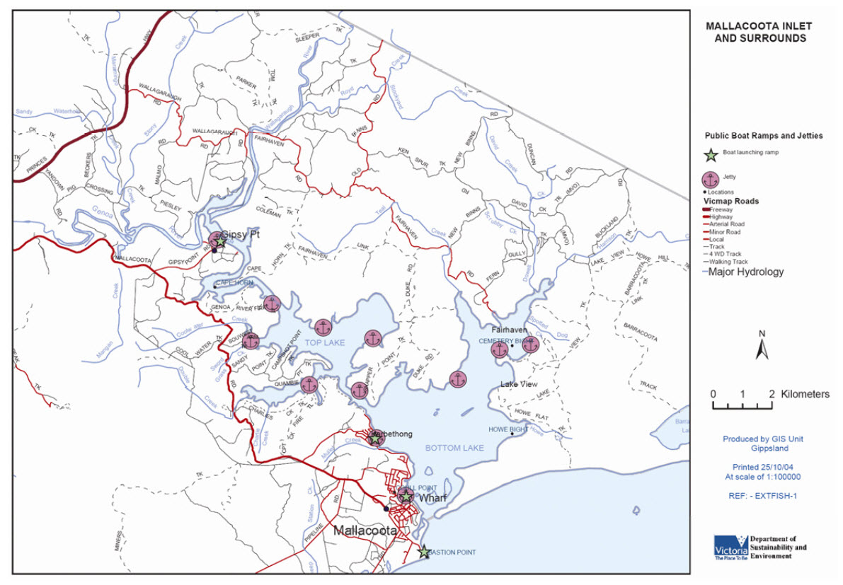
Boat-based fishing in Mallacoota Inlet is predominantly from small powered boats (up to six metres) that are usually launched from boat ramps located at the Mallacoota township, Gipsy Point or Karbeethong.
Shore-based fishing is restricted to a small number of locations (particularly jetties/landings and unvegetated foreshores) around the Bottom and Top Lakes and in some reaches of the Wallagaraugh River.
Key fish species
Information collected during public consultation processes for this management plan suggests that in recent years, the main target species for recreational fishers in Mallacoota Inlet are black bream and dusky flathead.
An extensive boat-based recreational fishing creel survey undertaken from 1981 to 1984 (Hall et al. , 1985) indicates that, in addition to bream and dusky flathead, smaller numbers of anglers were targeting a range of other species, including tailor, mulloway, luderick, King George whiting, garfish, Australian salmon and trevally. Other species that are caught in the inlet or have been targeted in the past include prawns, sand whiting and yellow-eye mullet. All target species are either permanent estuarine residents or rely on estuaries as nursery habitats (MacDonald et al. , 1997).
Fishing catch and effort
The only information on annual recreational fishing catch and effort within Mallacoota Inlet comes from a creel survey undertaken between December 1981 and June 1984 (Hall et al. , 1985) and from preliminary analyses of Victorian data from the 2000/01 NRIFS.
Hall et al. (1985) estimated that the mean angling effort to be 154,000 hours or 30,000 angler days. The estimated annual retained recreational catch was 48,000 fish with an estimated weight of almost 27 tonnes.
The main components of the recreational catch were black bream and dusky flathead, with smaller catches of trevally, tailor and snapper. Comparisons between the recreational and commercial harvest between 1981 and 1984 show that recreational anglers accounted for 36% of the total Mallacoota Inlet catches. Recreational anglers accounted for 44% of total bream catches, 93% of total dusky flathead catches, 27% of all tailor, 20% of all trevally and less than 5% of all luderick (Hall et al. , 1985; NREC, 1991).
Preliminary analysis of 2000/01 NRIFS data indicates that the estimated total annual retained catch of bream from Mallacoota Inlet was about 17,500 fish which represented about 40% of the total retained bream catch from the inlet that year. The estimated 2000/01 recreational retained catch of dusky flathead was about 73,000 fish which represented more than 95% of the total retained flathead catch from the inlet that year.
Commercial fishing
Commercial fishing has a long history within Mallacoota Inlet. The industry commenced in the 1880s and closed in 2003 when the remaining four Mallacoota Inlet Fishery Access Licences were cancelled. There is currently one fishing licence that permits eel fishing and several licences that allow for commercial bait fishing in Mallacoota Inlet.
The main target species for commercial bait collection are prawn and bass yabbies.
Recording of commercial fishing activities (total commercial catch by species) within Mallacoota Inlet began in 1916 and ceased in 2003.
Estuary and garfish seine nets were commonly used within the lower lake of Mallacoota Inlet. Annual commercial catches have varied considerably with a maximum of 220 tonnes recorded in 1953 and a minimum of 24 tonnes in 1966/67. Most catches since 1978/1979 were above 50 tonnes (DPI, 2001). Black bream and luderick were the main target species although significant catches of river garfish, Australian salmon, trevally, yellow-eye mullet, yellowfin bream and dusky flathead were also taken (NREC, 1991; MacDonald et al. , 1997).
Estimated wholesale market value of the annual commercial catch more than doubled from about $85,000 in the late 1970s to more than $200,000 in the last few years of the fishery (MacDonald et al. , 1997; Anon., 2001). Table 1 summarises the mean annual commercial finfish catches from Mallacoota Inlet between 1978 and 2003.
Table 1. Annual commercial fish catches (kg) from Mallacoota Inlet during 1978 – 2003
| Species | Highest Annual Catch | Lowest Annual Catch | Mean Annual Catch | % of Total Catch for the Period 1978-2003 |
|---|---|---|---|---|
| All species total | 118209 | 26093 | 72220 | 100 |
| Australian salmon | 40451 | 15 | 8485 | 12.4% |
| Bream, black | 31554 | 1264 | 13014 | 19A |
| Bream, yellowfin* | 4649 | 33 | 318 | 0.50% |
| Flathead, dusky (incl. small catches of sand & yank flathead) | 2939 | 206 | 1202 | 1.A |
| Garfish, all species | 11408 | 58 | 2885 | 4.20% |
| Leatherjacket | 2636 | 12 | 396 | 0.A |
| Luderick | 31014 | 1224 | 16318 | 23A |
| Mullet, sea | 12748 | 390 | 5213 | 7.60% |
| Mullet, yellow-eye, sand and flat-tail | 12684 | 1257 | 4278 | 6.A |
| Mulloway | 1102 | 29 | 310 | 0.A |
| Perch, estuary | 275 | 24 | 87 | 0.A |
| Prawn, all species | 4474 | 58 | 888 | 1.30% |
| Snapper | 444 | 2 | 75 | 0.A |
| Tailor | 15198 | 490 | 6028 | 8.A |
| Trevally | 16109 | 771 | 6757 | 9.A |
| Whiting, King George | 3539 | 4 | 652 | 1.00% |
| Whiting, sand | 2879 | 23 | 694 | 0.78% |
| Whiting, unspecified | 7182 | 42 | 1345 | 2.00% |
* Prior to 1995, species was not distinguished from black bream
Biology and ecological requirements of key target recreational fish species
The following descriptions of the biological and ecological characteristics of key target recreational fish species in Mallacoota Inlet are derived from published literature. While some recreational fishers have extensive knowledge of the distribution and behaviour of key fish species in Mallacoota Inlet based on personal observations, there has been little or no scientific investigation of the distribution, population dynamics or ecological requirements of fish species in the inlet. The list of species for the MIFRMP has been identified from the public consultation process and anecdotal evidence and is not considered to be a definitive list of key target species. Further information on species other than black bream, dusky flathead, silver trevally, yellowfin bream and Australian salmon can be found in Appendix 2.
Black bream
Black bream (Acanthopagrus butcheri) is an endemic species which inhabit estuarine waters of southern Australia to Western Australia with the range often found to overlap with yellowfin bream (Acanthopagrus australis) (Kailola et al., 1993). These two species are morphologically very similar and are said to hybridise in some areas where they coexist (Rowland, 1984).
Bream is a demersal species and may be found inhabiting rocky river beds, structures (e.g. jetties) and snags, and may be caught over seagrass beds, mud and sand substrates (Kailola et al., 1993; Cashmore et al., 2000). Black bream are rarely found at sea, although some adult bream may migrate between estuaries (Hall, 1984).
Larvae and small juvenile black bream are found primarily amongst seagrass beds which provide ideal habitat conditions including the availability of small invertebrate prey and adequate shelter for the species (Kailola et al., 1993; Cashmore et al., 2000).
Spawning for this species usually occurs from August in any given year; however it may begin later in more westerly estuaries (Cadwallader and Backhouse, 1983). Within the Gippsland Lakes, bream have been found to spawn from October to early December and in Mallacoota Inlet, black bream are thought to migrate upstream to the Genoa and Wallagaraugh rivers during spring (Hall et al., 1985). Anecdotal evidence from local fishers familiar with the inlet suggests that spawning occurs in deeper water with muddy bottoms as the deeper water is thought to provide protection (DPI,1999).
The survival of black bream larvae appears to be heavily dependent on suitable salinity and water temperature conditions as well as food and habitat availability (Kailola et al., 1993; Cashmore et al., 2000).
Female black bream first spawn at approximately 24 cm in length and can release between 300,000 and 3 million eggs depending on environmental conditions. Males become sexually mature at 22 cm (Butcher, 1945; Hall, 1984; Kailola et al., 1993).
Anecdotal evidence suggests that juvenile black bream in Mallacoota Inlet are mostly found in the Top Lake where the species lives in vegetated areas, with larger juveniles found in the Bottom Lake (DPI, 1999).
Black bream feed primarily on polychaetes with bivalves and amphipods considered a secondary component of their diet (Cashmore et al., 2000). Recreational fishers participating in the Mallacoota Inlet Fishery Assessment workshop in February 2006 reported observations of black bream closely associated with beds of small mussels in shallow water, suggesting that this is a significant source of food in Mallacoota Inlet (DPI, 2006a). Adult black bream are considered to be opportunistic feeders on a wide variety of prey including bivalve and gastropod molluscs, prawns and crabs, polychaete worms and small demersal fish (Rigby, 1982; Kailola et al. 1993; Cashmore et al., 2000).
Anecdotal evidence obtained from fishers participating in the Mallacoota Inlet Fish Habitat Assessment workshop in 1999 suggested that at the time, good catches of black bream occurred upstream of Gipsy Point and in the Wallagaraugh and Genoa rivers in the winter months (DPI, 1999).
Dusky flathead
Dusky flathead (Platycephalus fuscus) are an endemic species to Australia and are found in bays, estuaries and inshore coastal areas from Cairns in Queensland to the Gippsland Lakes in Victoria (Kailola et al., 1993).
Dusky flathead may be found residing over mud, silt, sand and gravel beds as well as seagrass beds (predominantly Zostera spp.) (Kailola et al., 1993). Anecdotal evidence from anglers presented at a Fish Habitat Assessment workshop in 1999 (DPI, 1999) suggests that in Mallacoota Inlet, dusky flathead use different parts of the estuary at different times of the year.
Dusky flathead are thought to spawn in response to water temperature and, therefore, the warmer months of January to March appear to suit the species spawning requirements. However, there are no published data on the frequency of spawning and fecundity (Kailola et al., 1993). Dusky flathead are thought to spawn from January to March in NSW and Victorian waters (Kailola et al., 1993). Anecdotal observations suggest that in Mallacoota Inlet, possible spawning grounds may be in the Bottom Lake around Harrisons Channel and sandbank areas from January to March (DPI, 1999; 2006b). However, it is possible that dusky flathead spawned in open coastal waters, or in estuaries up the east coast of Australia, may also be a source of juvenile recruitment to Mallacoota Inlet.
It has been found that dusky flathead are larger in size at the time of maturity in warmer waters compared with cooler waters (Kailola et al., 1993). Dusky flathead are ambush predators with prey including other fish (mullet or whiting), crabs, prawns, other crustaceans and polychaete worms (Kailola et al., 1993).
Kailola et al. (1993) suggests that it is possible for dusky flathead populations to be affected by loss of seagrass, sedimentation and changes in habitat and environment, particularly along east coast estuaries and inlets.
Anecdotal evidence and information collected from the public submission process for the preparation of this plan, suggests that dusky flathead are caught all year round. Higher levels of angling occur in the summer months throughout the inlet.
Yellowfin bream
Gomon et al. (1994) reports that yellowfin bream are endemic to the waters of eastern Australia, with a range from northern Queensland to the Gippsland Lakes.
Yellowfin bream reach maturity at three to four years of age (or about 24 cm in length) (Anon, 1981) and are thought to live up to 20 years of age (Henry, 1983). Individuals may change sex (male to female) after the first breeding season (Anon, 1981).
Pollock (1982) indicates that species found in Queensland generally spawn between late autumn to winter, with spawning taking place near the mouths of estuaries or in surf zones. Evidence presented by participants at the Mallacoota Inlet Fish Habitat Assessment workshop in 1999 indicates that the species may spawn up to 400-500 metres either side of the entrance (DPI, 1999).
Yellowfin bream eggs are thought to drift to sea and hatch approximately two to three days after fertilisation, with larvae developing in coastal waters (DPI, 1999). Pollock et al. (1983) reports that after about one month, post-larvae enter estuaries where they utilise plankton until they are about 13 mm in length. Zostera spp. and other shallow macrophyte beds are thought to be an important nursery habitat for juvenile yellowfin bream (West and King, 1996).
It appears that yellowfin bream use similar habitats to black bream, although the species is not constrained to estuaries and other brackish waters (Anon, 1981).
Yellowfin bream feed on a large range of organisms including crabs, prawns, shrimp, polychaete worms, molluscs and other small fish (Anon, 1981).
Silver trevally
Trevally species of the genus Pseudocaranx are widespread in temperate and sub-tropical waters of Australia, New Zealand, the Indian Ocean and the Atlantic Ocean (James, 1984). In Australia what was thought to be a single species, P. dentex, occurs from about Rockhampton in central Queensland around all southern states (including Tasmania) to North West Cape in Western Australia (Kailola et al., 1993).
Studies in the early 1990s have revealed that silver trevally in Victorian, Tasmanian, South Australian and Western Australian waters consist of two very similar species, P. dentex and P. wrighti (Gomon et al. 1994).
Juvenile silver trevally occur over soft substrates in estuaries, bays and shallow coastal waters, whilst adults are found either in shallow coastal waters or forming pelagic schools in deeper waters off the continental shelf (Last et al., 1983; James, 1976).
Spawning occurs during summer (Lenanton, 1977). Adult fish in spawning condition have been recorded from both estuaries and offshore areas (Winstanley, 1985), but spawning habitat preferences have not been identified. Anecdotal evidence from anglers attending the Mallacoota Inlet Fish Habitat Assessment workshop suggests that adults migrate into the inlet over the summer months where they are found residing in seagrass beds (DPI, 1999). Good catches of the species in Mallacoota Inlet have been observed through the winter months with adult species thought to leave the inlet at the end of winter (DPI, 1999).
Silver trevally can live for more than 40 years (James, 1978), and have been reported to grow to a total length up to 94 cm (Hutchins & Swainston, 1986) and up to 6 kg in weight (Last et al., 1983). However, trevally larger than about 38 cm length are uncommon in Victorian bays, estuaries and shallow coastal waters.
Silver trevally are opportunistic carnivores, adapted to both benthic and planktonic feeding modes. The benthic diet consists of polychaete worms, molluscs and small crustaceans, while surface schools of trevally consume planktonic crustaceans - particularly euphausids (krill). Juvenile trevally mainly consume micro crustaceans (Winstanley, 1985). Seasonal feeding preferences occur in adult trevally with a summer diet of essentially crustaceans shifting to mainly bivalve molluscs and fishes in winter (Anon., 1981).
Australian salmon
Australian salmon are migratory, schooling marine fishes found in coastal waters, bays and estuaries of southern Australia and up the east and west coasts to approximately 30°S (Kailola et al., 1993).
Morphological and genetic studies (MacDonald, 1980; 1983) have confirmed two species of salmon in southern Australian waters: western salmon (Arripis truttaceus) in waters of Western Australia, South Australia, Victoria and Tasmania; and eastern salmon (A. trutta) in waters of southern NSW, Victoria and Tasmania.
Eastern salmon predominate in East Gippsland waters and are relatively common as far west as Port Phillip Bay. Eastern salmon spawn in coastal waters of East Gippsland and southern NSW over the period November to April.
In Victoria, both western and eastern salmon up to 2+ years are found predominantly in bays and estuaries, often in association with seagrass beds. They can tolerate temperature and salinity extremes such as the brackish and turbid waters of estuaries, or the hyper-saline waters of the South Australian gulfs.
Eastern juveniles feed on zooplankton but are known to also prey on bottom-dwelling fauna such as fishes, squid, crustaceans and polychaete worms during winter months (Robertson, 1982).
Larger juvenile salmon (>30 cm length) move out of bays and estuaries into more exposed coastal waters, such as around rocky headlands and along surf beaches. Maturing salmon school up and move east or west along the southern coast to the respective spawning grounds of each species.
Migrating schools of adult salmon will sometimes 'rest up' near the mouths of inlets such as Mallacoota Inlet, and may occasionally move into such inlets to feed.
Significance of Mallacoota Inlet to Traditional Owners
Prior to European settlement, the far east Gippsland region was part of the Country of the Bidwell (Bidawal) Clan whose people occupied the coast between Green Cape NSW and Cape Everard (Point Hicks), inland to Delegate NSW and on the headwaters of the Cann and Bemm Rivers (Laughton, pers. comm.). The community/Traditional Owners were productive hunters and fishers who spent most of their time along the coastline, rivers and estuaries where fresh water and a diverse range of food was plentiful. Larger estuaries like Mallacoota Inlet were probably the richest food resource areas (Coutts, 1981). The Bidawal people also occupied Gabo Island for their ceremonies.
Mallacoota Inlet and surrounding country is still used by and has great cultural significance for aboriginal people/Traditional Owners based on traditions - including landscape and seascape values - descended from the original Indigenous custodians of Country in this area.
Sites of cultural significance
Mallacoota Inlet and surrounds (including Croajingolong National Park) contain areas of high significance including archaeological sites, middens, scarred trees, burial sites and scatters of stone artefacts (DNRE, 1996; AAV, 2002; EGCMA, 2005). Many of these sites have been listed on the Register of the National Estate. Other sites are of spiritual importance. Souvenir hunting, erosion and inappropriate recreation (including unauthorised access) have been identified as the main threats to these significant sites (DNRE, 1996). All sites of cultural significance and artefacts are protected by both State and Commonwealth legislation. Aboriginal Affairs Victoria (AAV) is the responsible authority for the administration of the relevant Acts. Enquiries in relation to registered or noted sites of significance should be directed to AAV. Any proposed works or use of Crown land are required to be carried out in accordance with the 'future acts' provision of the Native Title Act 1993, the Aboriginal and Archaeological Relics Preservation Act 1992 and part IIA of the Commonwealth Aboriginal and Torres Strait Islander Heritage Protection Act 1984.
Information regarding Indigenous fishing activities can be found under the 'Current Management Arrangements' section of the MIFRMP. Information pertaining to current controls on fishing by Indigenous Australians can also be found under the 'Current Management Arrangements' section.
Other uses of Mallacoota Inlet
Mallacoota Inlet is widely used by residents as well as visitors in peak holiday periods, not only for its recreational fishing activities, but also for the isolation and scenic attractions that the surrounding Croajingolong National Park (CNP) has to offer (Hall et al., 1985). The main attractions of the area are water and shore-based recreational activities, including bushwalking and wildlife observation within the adjoining CNP.
The main water-based activities undertaken in and around the inlet are beach combing, swimming, fishing, site seeing and wildlife observation.
Water-based activities
A large number of watercraft users enjoy the many opportunities the inlet has to offer including recreational boating, wind surfing, canoeing, kayaking, sailing, water-skiing, and personal watercraft use. Boat hire businesses are located at several points around the inlet, including Mallacoota, Karbeethong and Gipsy Point. There is at least one fishing charter operation in the inlet. Canoeing and kayaking are popular activities that occur throughout the inlet when weather and tidal conditions are suitable.
Water-skiing and personal watercraft usage are popular throughout the Top Lake and Bottom Lake, particularly at Cemetery Bight, the Narrows, Dead Finish, Cape Horn and Double Creek Arm, where water depths and shelter are conducive to such activities.
Nature tours also operate through peak seasons within the inlet.
While the inlet supports a variety of watercraft activities, increasing demand for these activities, particularly during peak holiday periods may lead to congestion both on the water and at boat launching access points.
Watercraft can be launched from a number of locations including Mallacoota, Karbeethong, Bucklands Jetty and Gipsy Point. The boat ramps at Karbeethong and Mallacoota are the most popular and in peak times may become congested.
There are a large number of public use jetties around the inlet where watercraft users can moor their vessels and enjoy public facilities particularly in the CNP area. Overnight stays are prohibited within the boundaries of the CNP adjacent to the inlet.
Commercial boat berthing opportunities are available near the Mallacoota township.
Shore-based activities
Major shore-based activities as identified by Hall et al. (1985), DNRE (1996) and EGSC (2001) include picnicking, photography, nature appreciation, camping, walking, bicycle riding, horse riding, site seeing and orienteering. Some activities may be restricted due to limited shore access or management constraints, particularly activities within the CNP.
Intensive use of some of the shore locations, particularly around the townships of Mallacoota, Karbeethong and Gipsy Point, has resulted in environmental degradation including the removal of indigenous vegetation, uncontrolled vehicle and pedestrian access, pest plant and animal establishment, and extension of private residential backyards onto foreshore Crown land (EGSC, 2001).
Current management arrangements
Following the removal of commercial fishing (other than for eels and bait) from Mallacoota Inlet in April 2003, and the declaration of the inlet as a fisheries reserve in January 2004, the focus for fisheries management has shifted towards maintaining and, where possible, improving recreational fishing opportunities in Mallacoota Inlet.
The following sections describe the policy framework, legislative tools, management processes and current controls that apply to recreational fishing in Mallacoota Inlet and other Victorian waters.
Legislative and policy framework for fisheries management
Legislation
Fishing activities in Mallacoota Inlet Fisheries Reserve and in all Victorian public waters are managed under the provisions of the Fisheries Act 1995 (the Act) and the Fisheries Regulations 1998 (the Regulations).
The Act provides a legislative framework for the regulation and management of Victorian fisheries and for the conservation of fisheries resources, including their supporting aquatic habitats. The stated objectives of the Act are:
- to provide for the management, development and use of Victoria's fisheries, aquaculture industries and associated aquatic biological resources in an efficient, effective and ecologically sustainable manner;
- to protect and conserve fisheries resources, habitats and ecosystems including the maintenance of aquatic ecological processes and genetic diversity;
- to promote sustainable commercial fishing and viable aquaculture industries and quality recreational fishing opportunities for the benefit of present and future generations;
- to facilitate access to fisheries resources for commercial, recreational, traditional and nonconsumptive uses; and
- to encourage the participation of resource users and the community in fisheries management.
The Act also provides for the development, implementation and review of fisheries reserve management plans, facilitates participation of stakeholders in fisheries management via fisheries co-management arrangements, and prescribes enforcement powers to assist in achieving compliance with fishing controls.
The Regulations prescribe detailed management arrangements for individual commercial and recreational fisheries, including licence requirements, restrictions on fishing equipment and methods, restrictions on fishing catch and or effort (bag limits, size limits, closed seasons/areas), and penalties for breaches of fishing controls.
It is important to note that the provisions of fisheries legislation (including Fisheries Notices) can only be applied to the control of fishing activities. Other human activities (e.g. catchment land use, foreshore development and other waterbased recreational activities) that may directly or indirectly affect fish habitats, fishery resources or the quality of fishing, are managed by different agencies under a variety of other legislation.
Policy
All Australian governments, including Victoria, have made a commitment to manage fisheries according to the principles of Ecologically Sustainable Development (ESD). These principles include:
- ensuring that fishing is carried out in a biologically and ecologically sustainable manner;
- ensuring that there is equity within and between generations regarding the use of fish resources;
- maximising economic and social benefits to the community from fisheries within the constraints of sustainable utilisation;
- adopting a precautionary approach to management – particularly for fisheries with limited data; and
- ensuring that the processes and procedures involved in management of a fishery are appropriate, transparent and inclusive.
There is an expectation in Australia and worldwide that utilisation of fish resources will be managed according to ESD principles, and they have been followed during the development of the MIFRMP.
Indigenous fishing activities
The provisions of the Commonwealth Native Title Act 1993 apply to all types of management of Mallacoota Inlet.
An application for a native title determination which covers parts of East Gippsland including Mallacoota Inlet, was lodged with Federal Court by the Bidwell People in 2002, but has since been discontinued.
In November 2000, the Victorian Government signed a Native Title Protocol with the Aboriginal and Torres Strait Islander Commission (ATSIC) and the native title representative body, Native Title Services Victoria. The protocol required the development of a statewide policy framework to address a broad range of native title related issues, including fisheries.
Initial discussions with stakeholder groups have been held to identify fisheries issues relating to native title.
The Victorian Government is currently working with Indigenous community representatives, Australian fisheries authorities and other fishing stakeholders to develop a national set of principles and pathways to facilitate definition and lasting recognition of customary fishing practices; increased opportunities for economic engagement of Indigenous communities in fisheries-related enterprises; and increased Indigenous participation in all aspects of fisheries use and management.
Current controls on fishing
Recreational fishing licence
A Recreational Fishing Licence (RFL) is required for angling, bait pumping, hand collecting and all other forms of recreational fishing in Victorian public waters, including Mallacoota Inlet. Some sectors of the community, including people under 18 or over 70 years of age, holders of a Victorian Seniors Card, and recipients of various age, disability or veterans benefits, are exempt from the need to hold this licence to go fishing.
Recreational fishing equipment
The Regulations define "recreational fishing equipment" as including a rod and line, handline, dip/landing net, bait trap, spear gun, hand-held spear, bait pump, recreational bait net and recreational hoop net. Recreational use of any equipment not included in this definition is prohibited in all Victorian public waters. The maximum permitted dimensions of dip nets, bait traps, bait pumps, recreational bait nets and recreational hoop nets are prescribed in the Regulations and summarised in the Victorian Recreational Fishing Guide.
Inland and marine waters
The Mallacoota Inlet Fisheries Reserve contains both marine and inland waters. The Bottom Lake has been classified as marine waters whereas The Narrows, Top Lake and waters upstream of Gipsy Point are classified as inland waters for the purposes of the Act.
Restrictions on use or possession of recreational fishing equipment in Victorian inland and marine waters are prescribed in the Regulations and summarised in the Victorian Recreational Fishing Guide. Most notably, anglers are currently restricted to using no more than two lines each in inland waters and no more than four in waters classified as marine. The possession and use of a speargun in Mallacoota Inlet is also prohibited.
Size and catch limits
Legal minimum sizes, bag limits, possession limits (in, on or next to fishing waters) and vehicle limits for fin fish and invertebrate species that may be encountered by recreational fishers in Mallacoota Inlet, are prescribed in the Regulations or current Fisheries Notices, and are summarised in the Victorian Recreational Fishing Guide.
Some size and catch limits have been introduced as measures to protect fish stocks from unsustainable fishing pressure. However, many of these limits have been adopted on ethical or cultural grounds, such as defining a reasonable take for personal consumption.
Since December 2003, recreational fishing for dusky flathead in Mallacoota Inlet and other Victorian waters has been subject to interim stricter catch limits, introduced by Fisheries Notice, to protect dusky flathead from increased targeting by anglers using increasingly sophisticated recreational fishing techniques.
Requirement to land fish in whole or carcass form
For some fish species with high commercial market value and which are subject to size limits, there is a requirement to retain captured fish in whole or carcass form until after they have been landed (brought ashore), in order to ensure compliance with recreational size and catch limits. Marine or estuarine fish species required to be landed in whole or carcass form include all shark species, elephant fish, King George whiting, bream, snapper and eels. In the case of sharks and elephant fish, 'carcass' means a fish which has been gutted and headed forward of the first gill slit, but has not been skinned or filleted. In the case of scale fish, 'carcass' means a fish which has been scaled and gutted, but has not been headed or filleted.
Intertidal collection of shellfish
Controls on intertidal collection of shellfish and other invertebrate animals are prescribed in the Regulations and are summarised in the Victorian Recreational Fishing Guide.
Currently, shellfish and other invertebrate animals may be collected by hand or using an approved bait pump from most Victorian intertidal waters, including Mallacoota Inlet. The use of a scoop, dredge, fork, spade, rake, shovel or other digging implement to collect invertebrate species from the intertidal zone throughout Victoria is prohibited.
Fishing by Indigenous Australians
The only types of fishing activities currently defined under the provisions of the Act and the Regulations are commercial fishing, recreational fishing and aquaculture. Access to Victorian waters for each of these types of fishing requires a licence or permit (although some categories of recreational fishers are exempt from this requirement), and is subject to a range of licence conditions and or regulations.
Customary fishing practices by Indigenous Australians are not identified as a distinct type of fishing activity under current Victorian legislation, and non-commercial fishing by Indigenous Australians is therefore treated as recreational fishing.
The Act does provide for the issue of permits to facilitate the taking of fish and other species for specified Indigenous cultural ceremonies or events.
Fishery co-management arrangements
Co-management is an inclusive arrangement that brings industry, community and government together to participate in the management of a natural resource. It assists those involved by improving their collective understanding of individual stakeholder needs and aspirations and by identifying behavioural modifications that can increase the long term viability of the resource – and therefore continued access to that resource by user groups.
The co-management of fisheries within Victoria is a process involving three entities. The first comprises the peak bodies, including VRFish and Seafood Industry Victoria.
The second entity comprises the Fisheries Comanagement Council (FCC) and its expertise based committees.
Finally, the third entity is the government agencies, including the Department of Primary Industries (DPI) of which Fisheries Victoria is a division.
The above co-management entities seek to ensure that fisheries interests are appropriately acknowledged and represented during consultation processes regarding decisions that may have an impact on any given fishery.
Management of non-fisheries uses/values in and around Mallacoota Inlet
Wildlife and native vegetation protection
Mallacoota Inlet and its shores contain a variety of aquatic and terrestrial habitats that support a diverse array of plant and animal species and communities, some of which may be protected under Commonwealth (e.g. Environment Protection and Biodiversity Conservation Act 1999) and or State legislation (e.g. Flora and Fauna Guarantee Act 1988).
All islands, sandflats, shoreline vegetation and mudflats (particularly Goodwin Sands) exposed in the Bottom Lake at low tide provide fauna, particularly migratory wading birds and shorebirds, with ideal feeding grounds and habitat (DNRE, 1996).
Noted rare or threatened aquatic species reported to occur in Mallacoota Inlet include the Cox's gudgeon, freshwater herring, Australian grayling and the Mallacoota burrowing crayfish (DNRE, 1996; EGSC, 2001). These species have been listed as threatened under Schedule 3 of the Flora and Fauna Guarantee Act 1988 and as a result, Action Statements are required specifying measures to protect these species. Implementation of Action Statements is the primary responsibility of the Department of Sustainability and Environment (DSE), with input from other stakeholders.
Coastal salt marsh and seagrass communities occur in parts of Mallacoota Inlet and are thought to provide important habitat, feeding and nursery grounds for a range of aquatic biota, including fish species.
Seagrass coverage in Mallacoota Inlet is approximately 6.5 km² (or 22% of the inlet area) with Zostera spp. being the most widely distributed species and Ruppia spp. also being observed in various locations (Blake et al., 2000).
The CNP surrounds much of Mallacoota Inlet and is managed by Parks Victoria. The CNP along with Nadgee Nature Reserve in NSW forms part of the Croajingolong National Park Biosphere Reserve designated under the United Nations Educational Scientific and Cultural Organisation (UNESCO) Man and the Biosphere Program (DNRE, 1996).
Key objectives and strategies for protection of biodiversity areas around Mallacoota Inlet are described in the Victorian Biodiversity Strategy (DNRE, 1997), the Mallacoota Foreshore Management Plan (EGSC, 2001) and in sections of the Croajingolong National Park Management Plan (DNRE, 1996).
Management of foreshore access and facilities
The Mallacoota foreshore, particularly between the Mallacoota township and Devlins Inlet, is a focal point for boat launching, cruises, sightseeing, walking, cycling, camping, fishing, horse riding and swimming.
Shore-based recreational activities tend to be concentrated around boating access points such as Mallacoota, Karbeethong and Gipsy Point. Public jetties are located around the inlet providing good access for picnicking and BBQ facilities and some walking tracks.
Parks Victoria manages a number of picnic facilities and jetties surrounding the inlet within the CNP. The park provides vehicle, vessel or walker access to these areas in accordance with the Croajingolong National Park Management Plan (DNRE, 1996).
Cape Horn Track, Genoa River Fire Trail, Souwest Arm Track and Sandy Point Track are all open to the public and provide vehicle, vessel and or pedestrian access to the Top Lake and Genoa River. Access to Goanna Bay, Gravelly Point, Captain Creek and The Narrows is by foot or vessel. Track maintenance is undertaken by Parks Victoria in accordance with the specifications of the Croajingolong National Park Management Plan (DNRE, 1996).
Strategic directions identified in the Victorian Coastal Strategy (VCC, 2002) include the requirement that public access to coastal Crown land will be maintained except where the interests of security, safety or protection of coastal resources predominate. The Strategy also specifies that public access to existing shore-based fishing facilities such as piers, jetties and wharves will be maintained, except where there are safety and security issues. New structures to accommodate access for fishing will be considered where this is supported by the appropriate land manager.
Detailed management proposals for Mallacoota Inlet foreshores, both outside and within the CNP boundaries, are described in the Mallacoota Foreshore Management Plan (EGSC, 2001) and the Croajingolong National Park Management Plan (DNRE, 1996) respectively.
The Mallacoota Foreshore Management Plan (EGSC, 2001) includes proposals to improve boat trailer parking, upgrade recreational infrastructure, and ensure that foreshore activities and developments do not degrade fish habitat.
Management of recreational boating and watercraft
Most of Mallacoota Inlet has been designated as a local port and is managed by Gippsland Ports in accordance with the Port Services Act 1995. Activities within ports are regulated by the Port Services (Local Ports) Regulations 2004. For further information on management of designated local port waters in Mallacoota Inlet, please refer to the Gippsland Ports website:
Boating activities in Mallacoota Inlet are regulated under the provisions of the Marine Act 1988 which is administered by Marine Safety Victoria. Recommendations for changes to boating regulations (including the appropriateness of water-skiing zones and vessel speed limits) in places such as Mallacoota Inlet may arise through public consultation processes conducted by organisations such as local Council or Gippsland Ports.
For further information on boating in this waterway, refer to Marine Safety Victoria – www.marinesafety.vic.gov.au and Gippsland Ports.
The Gippsland Boating Coastal Action Plan (GBCAP) (GCB, 2002) provides direction for the location and scale of boating use and development throughout the Gippsland coast. It also provides a framework for accommodating multiple uses and users of Gippsland waters. GBCAP identifies appropriate boating activities for 'coastal estuaries' such as Mallacoota Inlet are active nonpowered (i.e. sailing), passive non-powered (i.e. Mallacoota Inlet Fisheries Reserve Management Plan 15 canoeing) and passive powered boating (i.e. fishing). Active powered boating like water-skiing and fast cruising is identified as being more appropriate in lakes (inland or coastal) and marine waters. The Gippsland Coastal Board (GCB) is due to commence a review of the GBCAP in 2007.
Gippsland Ports (2005) has prepared a Safety and Environmental Management Plan (SEMP) in accordance with the Port Services Act 1995 which identifies all activities within the ports it manages, to ensure that all significant risks are identified and controlled.
Provision and maintenance of foreshore boating facilities and boating navigational aids
East Gippsland Shire Council (EGSC) is responsible for installation, maintenance and management of boat launching facilities around Mallacoota Inlet. Management of designated local port waters including installation, maintenance and management of lighting and navigation aids, is the responsibility of Gippsland Ports.
Karbeethong jetty is managed by Gippsland Ports while the adjacent boat launching ramp is managed by the EGSC. The GBCAP (GCB, 2002) identifies that both the ramp and jetty at Karbeethong are in satisfactory condition, but that the associated car and trailer parking need upgrading as a high priority.
Gippsland Ports manage the Main Wharf and associated slipway, the slipway jetty and the boat launching ramp jetty located at the township of Mallacoota, while EGSC manages the boat launching ramp. Gippsland Ports has confirmed that the slipway has been recently upgraded.
The Gipsy Point jetty is managed by Gippsland Ports, while the EGSC manages the boat launching ramp. Gippsland Ports has recently completed the reconfiguration and rebuilding of the existing Gipsy Point jetty. The GBCAP recommends an extension of the boat launching ramp into deeper water.
The EGSC administers most private jetties in Mallacoota Inlet on behalf of DSE. Other public jetties not specifically mentioned in this section are maintained and administered by either Parks Victoria or DSE.
All swing moorings found within Mallacoota Inlet are licensed through an annual permit system and administered by Gippsland Ports.
Publications including the Draft Boating Facilities Plan, Mallacoota Foreshore Management Plan, GBCAP and the Croajingolong National Park Management Plan are documents which outline specific management objectives and actions for the ongoing maintenance of relevant boating facilities and navigational aids found within the inlet.
Integrated management of Gippsland estuaries
The GCB, in partnership with the West and East Gippsland Catchment Management Authorities, is developing a Gippsland Estuaries Coastal Action Plan.
Coastal Actions Plans (CAPS) are developed under the provisions of the Coastal Management Act 1995 to address coastal issues and implement the objectives of the Victorian Coastal Strategy at a regional level.
The Gippsland Estuaries CAP will aim to provide a strategic framework for the future use, development and management of the major riverine estuaries within the Gippsland region. Implementing the CAP will assist in maintaining or enhancing aquatic and terrestrial environments and biodiversity, while maximising social and economic benefits from use of the estuaries. The Gippsland Estuaries CAP is due to be finalised in 2006.
Artificial entrance openings
The entrance at Mallacoota Inlet can open as a result of both artificial and natural processes. The entrance is sometimes opened artificially when high water levels threaten to have an adverse impact on infrastructure (particularly jetties and boat launching facilities) and land surrounding the inlet.
Currently, DSE and EGSC have the ultimate responsibility for any decision regarding artificial entrance openings at Mallacoota Inlet in consultation with Parks Victoria, Gippsland Ports, DPI (Fisheries Victoria), East Gippsland Catchment Management Authority (EGCMA) and community representatives. All works associated with entrance openings at Mallacoota Inlet are currently managed by DSE.
Entrance opening works may require a Works on Waterways Permit from the EGCMA. A permit is also required from Gippsland Ports in accordance with the Port Services Act 1995 for works within designated waters.
The Gippsland Estuaries CAP will address the issue of artificial openings of the entrance and, in particular, identify the appropriate stakeholders for decision making as well as the development of a decision support system to inform the process.
At a statewide level, a Steering Committee has been formed to prepare an Estuary Entrance Management Support System (EEMSS). The EEMSS will assist managers to decide whether or not to artificially open an estuary entrance and under what conditions. It is anticipated that the EEMSS may be applicable for Gippsland estuaries, including Mallacoota Inlet. Experts in relevant disciplines (including fisheries) and the community will be engaged to ensure that consideration is given to all possible environmental, social and economic impacts and benefits associated with the opening.
A number of options for the management of entrance openings are currently being considered by management agencies at both a statewide and regional level. Management options are expected to be finalised by December 2006.
Management of catchment activities and their impacts
The EGCMA was formed under the provisions of the Catchment and Land Protection Act 1994 and the Water Act 1989. The EGCMA works with the regional community, industry and government stakeholders to coordinate the development and implementation of strategies for integrated management of land and water resources in East Gippsland – including Mallacoota Inlet and its tributaries.
The East Gippsland Regional Catchment Strategy (RCS) identifies issues affecting all land and water within the East Gippsland region regardless of management obligations or ownership.
The RCS identifies six classes of assets; freehold land, state forest, parks, coastal & marine, groundwater, and catchment assets. Threats to the integrity of these assets and actions to manage the assets have been identified (EGCMA, 2005). General threats to the catchment asset class, as identified by the RCS include:
- Effects of inappropriate land use (including planning) on the environment, natural resource production and landscape amenity;
- Agricultural practices leading to offsite impacts and landscape changes; and
- Introduction of pest plants and animals and their potential impacts on the environment as well as natural resource production.
Implementation of management actions in the RCS will rely on a number of agencies and key stakeholders within the region, including DSE, DPI, Environmental Protection Authority (EPA), local government, private landholders and community based programs such as Landcare, Coast Action/Coastcare and Waterwatch.
The East Gippsland Regional River Health Strategy (RHS), is a sub strategy to the RCS. Threats to the health of the Genoa and Wallagaraugh rivers, the two major rivers flowing into Mallacoota Inlet, are identified in the RHS (EGCMA, 2006), and include:
- Presence of weeds, including willows;
- Loss of riparian vegetation;
- Bed instability and loss of in-stream habitat; and
- Damage to river health from inappropriate development.
Management actions identified through the RHS to address these threats include:
- Control or eradication of exotic vegetation in conjunction with NSW managers, landholders and other agencies;
- Stock exclusion through fencing of riparian vegetation;
- Foreshore and bank revegetation programs; and
- Implement recommendations of the Genoa River Expert Panel report (Brooks et al., 2001).
Movement of sand in the lower Genoa River
After an investigation into sediment sources in the Genoa River, Erskine (1992) found that the major source of sediment in the Genoa catchment was stream channel erosion. Other significant sources include: soil erosion within recently established pine plantations near Rockton; roading activities (particularly reconstruction of major highways in the area); and the potential for erosion resulting from the passage of intense wildfires (Brooks et al., 2001).
The EGCMA established an Expert Panel in 2000 to report on the status of sedimentation in the lower Genoa River.
The Genoa River between Genoa and Gipsy Point is defined as a sand storage zone for sediment that has been transported through the lower Genoa gorge. A channel recovery program for this area has been established and includes an intensive revegetation program. The Expert Panel concluded that "…it is unlikely that the sand in the reach will move in any quantity into the Genoa River estuary or Mallacoota Inlet" (Brooks et al., 2001 page 52).
Management recommendations of the Expert Panel, in conjunction with stakeholders, to address the threat of sediment deposition and movement in the Genoa River include:
- Excluding stock from waterways;
- Maintenance/enhancement of revegetation in riparian zones;
- Re-establishment of vegetation within the channel bed and on the river edge;
- Management of pest plants; and
- Maintenance and enhancement of existing works and vegetation.
River health works undertaken on the Genoa River over the past few years include:
- Establishment of strong cross border partnerships with NSW land managers to ensure an integrated approach to land management;
- Majority of river frontage fenced to promote rehabilitation of the riparian zone and vegetation;
- Willow control program along the Genoa River from the NSW border downstream; and
- Management of the sand slug at Genoa including re-establishment of vegetation in the riparian zone and sand bed, and placement of large pieces of wood within the sand bed for stabilisation.
Aquatic pest plant and animal management
The introduction of exotic organisms into Victorian marine waters has been listed as a 'Potentially Threatening Process' under the provisions of the Flora and Fauna Guarantee Act 1988 administered by DSE. Action Statements will be developed describing how these and other potentially threatening processes are to be addressed in Victoria. Other listed potentially threatening processes of relevance to estuaries such as Mallacoota Inlet, can be found at www.dse.vic.gov.au. Marine pest emergency response arrangements, known as the "Interim Victorian Protocol for Managing Exotic Marine Organism Incursions", currently form the basis for responding to introductions and incursions of marine pests.
The introduced European Shore Crab and Pacific Oyster have been recorded in Mallacoota Inlet. However, anecdotal evidence suggests that populations of these species have not shown any signs of increased abundance or expansion of their distribution within the inlet. The reasons for this lack of expansion are unclear. Although no formal monitoring programs are in place for these species, observations from recreational fishers will be used to monitor changes of distribution.
Mallacoota Inlet Fisheries Reserve Management Plan
The overall purpose of the MIFRMP is to formalise management arrangements for the Mallacoota Inlet Fisheries Reserve in accordance with the provisions of the Act, the Ministerial guidelines and the principles of Ecologically Sustainable Development.
To this end, the MIFRMP specifies goals, objectives, strategies and actions for management of fishing activities in the reserve.
The MIFRMP also identifies processes for management of other non-fishing values and uses of the inlet, and opportunities for fisheries stakeholders to participate in these processes to ensure identification and minimisation of potential adverse impacts on fish habitat and fisheries.
The MIFRMP contains a section describing research and monitoring information needed to address the identified management objectives and performance indicators, a section outlining a strategy for promoting compliance with fishing controls in the inlet, and a section describing implementation and future review processes.
Duration of the MIFRMP
The MIFRMP will provide the basis for the management of the Mallacoota Inlet Fisheries Reserve for a period of 10 years unless established fishery monitoring and assessment programs indicate a need for a review prior to that time.
Review of the MIFRMP
Review of the MIFRMP and preparation of a new MIFRMP will commence twelve months prior to the scheduled expiry of the MIFRMP. The review will examine all aspects of fisheries management against the defined goals, performance indicators and reference points, and will examine the need for new or amended objectives in light of monitoring and research information obtained.
Should there be a need for the Minister to amend the MIFRMP prior to this review, notice of this intention will be published in the Government Gazette.
The planning process
Requirements of the Fisheries Act 1995
The Act stipulates that a management plan must be prepared for a fisheries reserve as soon as possible after the Reserve has been declared under section 88 of the Act.
Each declared fisheries reserve management plan must:
- define the fishery or fisheries to which it relates;
- be consistent with the objectives of the Act and, in the case of a fisheries reserve, be consistent with the Order in Council declaring the reserve;
- specify objectives for management of the fishery or fisheries covered by the plan;
- specify the management tools and any other measures to be used to achieve the objectives of the plan;
- specify performance indicators, targets and monitoring methods for the objectives and management actions stated in the management plan;
- as far as is known, identify critical components of the ecosystem relevant to the management plan, any current or potential threats to those components, and existing or proposed measures to protect or maintain these ecosystem services; and
- as far as relevant and practicable, identify any other biological, ecological, social and economic factors relevant to the fishery or fisheries covered by the plan including: fishery trends and current status; the socio-economic benefits of fishing and other human uses of the area or resources in question; measures to minimise the impact of fishing on non-target species and the environment; fisheries-related research needs and priorities; and an assessment of the resources required to implement the management plan.
The Act also indicates that each management plan may:
- specify the duration of the management plan;
- specify procedures and or conditions for review of the plan;
- in the case of a fisheries reserve, specify guidelines regulating or restricting activities in the reserve;
- in the case of a fisheries reserve, specify terms and conditions under which any special activities in the Reserve may be permitted; and
- include any other relevant matters.
Additional direction on the development of the MIFRMP has been provided by the gazettal of Ministerial guidelines on 11 May 2005 (see Appendix 3).
Requirements of the Native Title Act 1993
Native Title describes the interests and rights of Aboriginal and Torres Strait Islander people in land and waters according to their traditional laws and customs that are recognised under Australian Law (NNTT, 2000). The MIFRMP is required by law to adhere to the requirements of the Native Title Act 1993 as a part of the planning process which allows Native Title parties an opportunity to comment on the MIFRMP through a 28-day notification process.
Advice on particular situations relating to East Gippsland (particularly Mallacoota Inlet) is available through the Native Title Coordinator at the Traralgon Office of the DSE.
Steering Committee
The MIFRMP was prepared by Fisheries Victoria, assisted by a Steering Committee consisting of an independent chair and representatives from key stakeholders including VRFish, FCC, EGSC, Parks Victoria, EGCMA and Indigenous interests.
The role of the Steering Committee was to advise the Executive Director, Fisheries Victoria, DPI, on the preparation and consistency of the MIFRMP with respect to the requirements of the Act and the Ministerial guidelines, and to assess public submissions from community consultation on the draft MIFRMP.
The Terms of Reference for the Steering Committee and the list of the stakeholder representatives are provided in Appendix 4.
Public consultation
The first step in the preparation of the MIFRMP was to seek the views and comments of recreational fishers and other community interests regarding the values and issues associated with fishing in Mallacoota Inlet.
Two meetings were held in Mallacoota in July 2005 to explore these issues and values. Members of the public and recreational fishers who were unable to attend the meetings were invited to submit their views and comments in writing by the end of August 2005.
Approximately thirty-five written and verbal submissions were received as a result of the initial consultation process. The information collected guided the drafting of the MIFRMP to ensure it had a strong focus on addressing fishing-related issues that matter to both visiting and resident recreational fishers and the local community.
Values and issues raised during the first round of public consultation included:
- Mallacoota Inlet is valued by recreational fishers because it provides a safe environment for shore and boat based fishing, and has reasonable infrastructure and services;
- Mallacoota Inlet is highly regarded as a black bream and dusky flathead fishery. Other identified target species included mulloway, Australian salmon and prawns;
- a proportion of respondents wanted size limits increased for dusky flathead;
- the introduction of a seasonal closure of recreational bream fishing in waters upstream of Gipsy Point (including the Genoa and Wallagaraugh rivers) to protect black bream spawning stocks was proposed; however, others opposed the closure of any waters to recreational fishing;
- a number of individuals indicated they would like to see an increase in locally available information about where and how to catch fish in Mallacoota Inlet;
- concerns were raised about the possible impacts of a variety of habitat and environmental issues on fish production and therefore fishing in the inlet. Issues raised included erosion and sediment deposition from inappropriate land use, foreshore vegetation removal and logging in the upper Genoa and Wallagaraugh catchments; sand movement inside the inlet; closure and artificial opening of the entrance; and water quality in the inlet;
- concerns were raised about the quality and quantity of access to the inlet for both boatbased and shore-based fishing; and
- issues regarding competition and conflict between recreational fishers and other waterbased users of Mallacoota Inlet.
A second round of public consultation calling for comments and views on the Draft MIFRMP was held in early 2006 for a period of sixty days.
Amendments to the MIFRMP were made as a result of the seven submissions received.
Management goals and objectives
The following broad goal and objectives apply to management of fishing activities in the Mallacoota Inlet Fisheries Reserve.
Goal
To manage Mallacoota Inlet fish stocks and the fisheries they support, and to identify and promote protection of important fish habitats in a manner that is sustainable and which provides optimum social and economic benefits to all Victorians in accordance with ESD principles.
Objectives
- Social – To maintain, and where possible, enhance recreational fishing opportunities in Mallacoota Inlet.
- Biological – To conserve and ensure sustainable use of key fish stocks in the inlet.
- Environmental – To identify and promote protection of the habitats and environments which are essential for production or maintenance of key fish stocks in the inlet.
- Governance – To achieve maximum community participation, understanding and support for the management of fishing activities in the Mallacoota Inlet Fisheries Reserve.
Strategies
More detailed accounts of the strategies, management actions, performance indicators and information needed to address each of these objectives are provided in the following sections and are summarised in Table 2.
Some of the issues raised during the development of the MIFRMP cannot be directly dealt with in accordance with fisheries legislation. For these issues, the MIFRMP attempts to identify other processes whereby recreational fishing interests can ensure their concerns are addressed.
Performance indicators are provided for actions that Fisheries Victoria has direct responsibility for implementing. These indicators provide a means of tracking progress on an ongoing basis.
Performance indicators are not provided for actions that other agencies are responsible for implementing.
Recreational fishing opportunities
Strategy 1 - Monitor fishing values or preferences in Mallacoota Inlet
Recreational fishing-based tourism is considered to be a major contributor to economic activity in small coastal towns such as Mallacoota and Gipsy Point. Available anecdotal evidence and information from recreational fishing surveys (e.g. Hall et al., 1985) suggests that the quality of angling (measured as both numbers and size of fish caught) is considered to be one of the main attractions for visitors to the Mallacoota Inlet area.
Preliminary information obtained from verbal and written submissions during the first phase of public consultation in July 2005 indicated that Mallacoota Inlet is a preferred fishing location because of:
- its proximity to NSW;
- safety of the inlet for boat and shore-based fishing;
- reasonable access for aged or impaired anglers;
- infrastructure and services provided by the township of Mallacoota which supports recreational fishers; and
- range of fish species within the inlet.
Occasional creel surveys of recreational fishing in Mallacoota Inlet conducted since the early 1980s have indicated that bream (mostly black bream) and dusky flathead have been the most popular recreational target species in the inlet for at least the last 25 years. Hall et al. (1985) found that in the early 1980s about 38% of surveyed Mallacoota Inlet anglers specified bream as their primary target species, while about 23% of anglers specified dusky flathead. Fewer than 2% of surveyed anglers nominated any other species as a primary target species, and about one third of anglers were not fishing for any species in particular.
Surveys of Mallacoota Inlet conducted in 2000/01 (as part of the National Recreational and Indigenous Fishing Survey) and in 2004/05 (to evaluate the impact of new stricter dusky flathead catch limits) have confirmed the popularity of bream and dusky flathead as primary angling target species, but have also indicated that targeting of dusky flathead - particularly using artificial lures - has increased much faster than for bream in recent years.
Other information on recreational fishing values or preferences provided by the early 1980s survey included:
- more than 85% of fishing trips to the inlet were by visitors to the Mallacoota Inlet area. Of the local resident anglers, a substantial proportion were retirees;
- there are substantial seasonal fluctuations in recreational fishing effort in the inlet, with peak periods coinciding with public holiday or school holiday periods;
- less than 15% of total recreational fishing effort in the inlet was shore-based with the Bottom Lake slightly more popular for shorebased fishing than the Top Lake;
- prawns and Bass yabbies were the most popular baits for bait fishing in the inlet;
- less than 5% of interviewed anglers were using artificial lures in the inlet in the early 1980s, however anecdotal evidence suggests that in recent years the proportion of anglers using hard body or soft plastic lures has increased significantly; and
- catches of bream dominated in the Top Lake and rivers, while catches of dusky flathead dominated in the Lower Lake.
Ongoing periodic surveys of this kind are needed to provide up-to-date information and to detect changes in the demographic profile of recreational fishers (e.g. proportion of visitors versus local residents, residential origins of visitors) or in the values or preferences individuals attach to fishing in the inlet (e.g. preferred target species, preferred fishing methods, locations and or seasons, and acceptable catch rates for a particular species). This information is required in order to determine what fishers value or prefer in their recreational fishing experiences and, therefore, what fisheries management actions may help to maintain or enhance recreational fishing opportunities.
Information requirements
Surveys of representative samples of Mallacoota Inlet recreational fishers are needed to provide information on fishing values or preferences associated with fishing in the inlet. These surveys need to be conducted periodically to initially benchmark and then detect any changes in fishing values or preferences.
The most cost effective collection of such information is likely to be through periodic attitudinal surveys at fishing access points around the inlet (for visiting and local non-club fishers) and through direct survey of local fishing club members.
Performance indicator
- Information on profile of recreational fishing collected from at least 200 anglers per survey.
Actions
- Fisheries Victoria to establish periodic surveys of anglers to provide information on fishing values or preferences. The first survey to be conducted within the first two years following declaration of the MIFRMP and a minimum of one additional survey in the remaining life of the MIFRMP.
- Fisheries Victoria, in consultation with recreational fishing stakeholders, to evaluate possible fishery management actions to maintain or enhance recreational fishing opportunities based on the results of surveys.
Strategy 2 - Maintain or enhance levels of satisfaction with fishing opportunities
Having identified factors that contribute to a satisfying recreational fishing experience in Mallacoota Inlet, there is a need to periodically monitor levels of satisfaction with fishing opportunities and experiences in the inlet. This will involve surveys of recreational fishers to provide information on the amounts and types of fish caught, satisfaction with the fishing rules and regulations applying to Mallacoota Inlet, and any non-fishing factors that may be affecting the quality of recreational fishing experiences.
Submissions from the first phase of public consultation in July 2005 indicated that:
- some individuals believed that fishing in the inlet is as good now as it has been for many years, with a number suggesting that fishing has improved in the Bottom Lake since the removal of commercial fishing in 2003;
- black bream and dusky flathead are probably the highest profile target fish species in the inlet, with other popular species including estuary perch, prawns, Australian bass, whiting, Australian salmon and mulloway;
- a number of submissions indicated that the fishing experiences of visitors to Mallacoota Inlet are likely to be enhanced if they had ready access to information (through local tourism businesses and local media) on where and how to successfully fish the system;
- fishing experiences were sometimes diminished because of poor access to congested boat ramps during peak fishing times; and
- some fishing access points are not adequately maintained (including the fisheries jetty, the Narrows and tracks around the Top Lake).
Information requirements
Surveys of representative samples of Mallacoota Inlet recreational fishers are needed to provide information on levels of satisfaction associated with fishing in the inlet. These surveys need to be conducted periodically to initially benchmark and then detect any changes in levels of fishing satisfaction that underpin perceptions of satisfaction.
The most cost effective collection of such information is likely to be through periodic attitudinal surveys at fishing access points around the inlet (for visiting and local non-club fishers) and through direct survey of local fishing club members.
Performance indicator
- A minimum of 60% of fishers satisfied with fishing opportunities.
Actions
- Fisheries Victoria to establish periodic surveys of anglers to provide information on levels of fishing satisfaction. The survey may be linked to and conducted in conjunction with the survey identified in Strategies 1, 4 and 5. The first of these surveys is to be conducted within the first two years following declaration of the MIFRMP and a minimum of one survey in the remaining life of the MIFRMP.
- Where information collected during periodic angler surveys indicates support for a review of recreational fishery management arrangements in order to maintain or enhance fishing opportunities and experiences, Fisheries Victoria will evaluate possible fishery management actions in consultation with stakeholders.
Strategy 3 - Identify and encourage responsible recreational fishing behaviour
Many regulations applying to recreational fishing in Victorian waters have been introduced at the request of recreational fishers for ethical or cultural reasons, including concerns about future stock conservation issues rather than because of a scientifically identified need to protect fish stocks from excessive fishing pressure. A number of daily bag limits and possession limits have been introduced or amended to define a 'reasonable' daily take for personal use, and some size limits have been introduced to define minimum acceptable sizes of fish for human consumption. Regulations introduced or amended for these reasons have, in nearly all cases, been applied uniformly to all Victorian waters.
Preliminary information obtained from verbal and written submissions during the first phase of public consultation on the development of the MIFRMP indicated that many recreational fishers were satisfied with existing controls on recreational fishing in Mallacoota Inlet and did not want to see any changes. However, a number of submissions called for changes to catch limits and or size limits for particular species - including black bream, dusky flathead and estuary perch - for ethical or cultural reasons. Such reasons include stock conservation issues, defining a 'reasonable' number of fish to take for personal use in a days fishing, or defining the minimum size of a particular type of fish that is acceptable for eating purposes.
Victorian recreational fishing catch limits were revised in 2000 after a four year review process that included extensive consultation with the Victorian Recreational Fishing peak body (VRFish) and several rounds of public comment on proposed catch limits. Current bag and possession limits for estuary perch, bream (except in the Gippsland Lakes), Australian salmon, flathead (other than dusky flathead), King George whiting and sand worms were established on the basis of what the majority of Victorian recreational fishers considered to be reasonable, desirable or acceptable.
More recently, further requests have been made by recreational fishers for statewide reviews of size or catch limits of particular species. These requests will be considered in consultation with VRFish and the recreational fishing community during a review process to be initiated in 2006.
In light of this information, the MIFRMP will not initially contain any changes to recreational catch or size limits that are proposed for ethical or cultural reasons.
Recreational fishers have contributed to the identification of responsible fishing behaviour through the development of a Victorian Recreational Fishing Code of Conduct. This document was released by VRFish in 2004 and provides guidance to recreational fishers on issues such as protecting the environment, respecting the rights of others, attending fishing gear, being aware of and complying with fishing restrictions, returning of unwanted fish to the water, valuing fish caught and passing on fishing and local knowledge to new fishers.
The National Strategy for the Survival of Released Line Caught Fish is an initiative of the Fisheries Research and Development Corporation (FRDC) in association with Recfish Australia and the Australian National Sportsfishing Association (ANSA). The main aim of this strategy is to improve the survival rate of fish which have been caught by hook and line and released (e.g. because they are undersized), through a better understanding of the effects of fishing catch and release on the survival of released fish, and through adoption of 'best practices' in handling released fish. Further information on the National Strategy for the Survival of Released Live Caught Fish can be obtained from www.infofish.net/releasefish/
Performance indicator
- Fishing restrictions introduced to identify and encourage responsible recreational fishing behaviour will reflect the views/values of a majority of recreational fishers.
Actions
- VRFish to facilitate the distribution of the Victorian Recreational Fishing Code of Conduct through appropriate outlets in the region, including (where available) through Fishcare groups, agents who sell recreational fishing licences, fishing-dependent tourism businesses and fishing clubs.
- Where information collected during periodic angler surveys (Strategies 1 & 2) indicates support for a review of recreational fishing controls, Fisheries Victoria will consider this information in future reviews of fishery management arrangements in consultation with stakeholders. Any changes made to recreational fishing controls for cultural or ethical reasons may apply specifically to Mallacoota Inlet, but are more likely to apply statewide. Review of fishing controls to occur within twelve months following the collection of information indicating the need for a review.
- Information obtained from Mallacoota Inlet regarding dusky flathead catch and size limits to be considered in the recreational catch and size limit review process to be initiated in 2006.
Sustainable use of fish resources
The Mallacoota Inlet recreational fishery is relatively small by comparison with other recreational and commercial fisheries under Victorian jurisdiction. The fishery is also complex, being characterised by targeting of a variety of fish species using several different fishing methods, and by substantial fluctuations in fish abundance that can be driven as much by habitat and environment conditions as by the effects of fishing.
Objectives, strategies and performance indicators for sustainable use of Mallacoota Inlet fish resources will therefore need to be achievable and cost effective given limited resources for fishery monitoring, assessment and management.
Strategy 4 – Assess the status of black bream and dusky flathead stocks and ensure sustainable fishing
In small estuarine fisheries such as Mallacoota Inlet where the resources available for fishery monitoring, assessment and management are limited, more detailed investigations of stock status and the effects of fishing can only be justified for the one or two most important target species.
For each key species, collection of information on reproduction, growth, population structure and recruitment patterns, together with fishery catch and effort information, is essential to detect fluctuations in abundance (whether driven by environmental or fishing factors) and to decide whether or not adjustments to fishery management arrangements are needed to ensure continued sustainable use.
The only systematic surveys of recreational fishing catch and effort in Mallacoota Inlet to date have been a roving creel survey of the entire estuary from December 1981 to June 1984 (Hall et al., 1985), a roving creel survey of the Top Lake and rivers from April to August 1999 (DPI, 2001), and a boat ramp access point survey of the Bottom Lake and Top Lake which commenced in July 2004 and is scheduled to conclude in June 2006. Comparisons of results from different survey designs should be treated with caution.
Available evidence from recreational fishing surveys, together with the results of the first round of public consultation on the development of the MIFRMP, indicate that black bream and dusky flathead are currently the two most important recreational target species in Mallacoota Inlet. Resources available for stock assessment and fishery management strategy evaluation in Mallacoota Inlet will therefore initially be focused on black bream and dusky flathead.
Black bream
Black bream normally spend their entire life cycle in estuaries such as Mallacoota Inlet and, consequently, their abundance is likely to be substantially influenced by environmental and or habitat factors in the inlet that determine fluctuations in spawning success, survival of young fish, and the abundance of successive year classes of fish.
Black bream populations in Mallacoota Inlet and other Victorian estuaries are characterised by 'episodic' recruitment - that is, populations that consist of a few 'strong' year classes resulting from years when there is successful spawning and high survival rates, interspersed with a larger number of 'average' to 'weak' year classes resulting from years of lower spawning success and or lower survival rates (MacDonald, 1997; Coutin et al., 1997; Coutin, 2000; Cashmore et al., 2000). When fish in strong year classes grow large enough to reach the legal minimum size (that is, to be 'recruited' to the fishery), fishery trends are characterised by an increase in catch rates and a decrease in the average size of bream above the legal minimum size.
Strong year classes, once recruited, will sustain bream fisheries for a number of years thereafter. However, if a strong year class is followed by a number of consecutive years of average to weak year classes, then fishery trends will be characterised by a gradual decline in catch rates, but also possibly by an increase in the average size of bream above the legal minimum size.
Regardless of the reasons for observed fluctuations in year class abundance of bream, if patterns of 'strong' and 'weak' year classes of prerecruits (fish that are not yet big enough to enter the fishery) can be monitored, then fishery trends can be predicted several years in advance. This will allow the development of 'adaptive' fishery management arrangements, whereby fishing restrictions are tightened to provide additional protection from fishing pressure when stocks are low due to persistent poor recruitment, and are relaxed to allow fishers to take advantage of abundant stocks when one or more strong year classes are recruited to the fishery.
Preliminary analyses from systematic surveys of recreational fishing catch and effort in Mallacoota Inlet indicate that retained bream catch rates in 1999 and 2004/05 were at least as good, if not better, than those recorded in the early 1980s.
Comparison of the size distribution of bream measured in these surveys indicates that in all three cases, there are a number of size modes in the retained bream catch, and larger, older fish (≥ 30 cm total length) constitute a substantial portion of the total catch. This type of size distribution is consistent with a fish population that periodically has relatively good recruitment, and is not subject to excessive fishing pressure.
Since 1997, the size and age composition and relative year class abundance of Mallacoota Inlet black bream stocks have also been monitored by a small number of anglers who have volunteered to keep detailed log book or diary records of their bream fishing activities and catches, and who provide biological samples to Primary Industries Research Victoria (PIRVic) scientists for analysis. Log book data from this program, together with the visual observations of the angler diarists, indicate that relatively strong year classes of prerecruit (undersize) bream have been observed on several occasions in the inlet since the log book program commenced.
Only two formal assessments of fisheries in Mallacoota Inlet have been conducted to date – in 1994 and 2001.
MacDonald et al. (1997) described the history and current status of the Mallacoota Inlet commercial fishery as at 1994. Lack of biological data on key target species at the time prevented full assessment of the status of Mallacoota Inlet fish stocks. However, based on analysis of commercial catch and effort data, MacDonald et al. (1997) concluded that, with the possible exception of black bream, there was no evidence that commercial and or recreational fishing activities had resulted in any obvious decline in fish stocks in the 20 years prior to 1994. Uncertainties regarding the status of black bream arose from an:
- inability to separate catches of black bream (Acanthopagrus butcheri) from catches of the closely related silver or yellowfin bream (A. australis) (these species were not recorded separately in commercial catches until 1995). While total annual bream catches were relatively stable in the 20 years prior to 1994, the proportional contribution of each species to the total catch may have been changing; and
- observed gradual decline in haul seine catch rates of bream in the 10 years prior to 1994 may have been due to increasing fishing effort, or increased targeting of other species (e.g. luderick), rather than a decline in the abundance of bream.
A further assessment of Mallacoota Inlet fisheries was conducted by stakeholder and Departmental representatives at a workshop in 2001 (DPI, 2001). This assessment updated commercial fishery trends since 1994, and also analysed available recreational angler diary information and size/age composition data for black bream.
While assessments were still subject to some uncertainty because of limited data, workshop participants found that existing levels of commercial and recreational fishing pressure posed no immediate threat to the sustainability of fisheries for bream or other species in Mallacoota Inlet. None of the indicators of the status of fisheries suggested cause for concern, nor did they point to significant changes caused by fishing (either recreational or commercial) that would indicate the need for change to fisheries management arrangements.
The most recent assessment of the Mallacoota Inlet fisheries was undertaken in February 2006. This assessment updated commercial fishery trends from 2001 until its closure in April 2003 and also analysed recreational angler diary information, NRIFS data and creel surveys from 1998 & 1999 and 2004-2006.
Black bream size and age composition information provided by research anglers indicated that in 2005, the Mallacoota Inlet bream population was dominated by fish between 2 & 6 years of age, together with significant numbers of fish from previous abundant year classes which are now 10 & 11 years of age.
In view of this finding, and given that the closure of commercial fishing in Mallacoota Inlet in 2003 has probably substantially reduced total fishing pressure, the MIFRMP will not initially contain any proposal to change existing recreational bream fishery controls.
It should be noted that in recent years some local Mallacoota residents and some anglers have raised concerns that Mallacoota Inlet bream stocks are severely depleted because of excessive fishing pressure, and have proposed that they be given extra protection by closing the upper part of the estuary (the Wallagaraugh River and Genoa River upstream of Gipsy Point) to recreational bream fishing during the bream spawning season.
While these genuine concerns for the well being of valuable fisheries resources are acknowledged and respected, introduction of a bream fishing closed season in Mallacoota Inlet is not currently being considered for the following reasons:
- available scientific evidence collected in recent years does not suggest any significant decline in bream abundance, nor any persistent poor recruitment;
- the 2001 and 2006 Mallacoota Inlet Fisheries Assessment workshops found that levels of commercial fishing (up until April 2003) and recreational fishing pressure existing at the time posed no immediate threat to the sustainability of bream stocks, and there was no need to change existing fisheries management arrangements;
- overall fishing pressure in Mallacoota Inlet has been significantly reduced by the removal of commercial fishing in 2003;
- if additional protection of black bream stocks from fishing pressure was needed, it is not clear that closing only part of the estuary to bream fishing for part of the year would be the most effective management tool for providing such protection. Other management measures (e.g. changes to size and or catch limits) would also need to be evaluated, and the impacts of any chosen measures on levels of fishing-based tourism in the Mallacoota area would also have to be considered; and
- some submissions received during the initial round of public consultation for the development of the MIFRMP indicated that recently fishing for black bream in Mallacoota Inlet has been excellent and that the numbers of both size and under-sized bream was felt to be increasing over the last few years.
Results from angler diary programs and creel surveys will be reviewed as information becomes available, and will be used to determine the most appropriate management measures (e.g. size/bag limits, seasonal closures) to ensure the sustainable use of fish resources in Mallacoota Inlet.
Dusky flathead
Very little is known about the biology, population structure or recreational fishery trends for dusky flathead in Mallacoota Inlet.
Elsewhere in eastern Australian waters, dusky flathead are found primarily in estuaries, although they also occur in near-shore marine waters, and some adult fish are known to migrate substantial distances up or down the coastline (Kailola et al., 1993; Gray et al., 2002, 2004). Therefore, the abundance and population structure of dusky flathead in estuaries such as Mallacoota Inlet is likely to be substantially influenced by environmental and or habitat factors in the inlet that determine fluctuations in spawning success, survival of young fish, and movement of fish in and out of the inlet.
Commercial fishery records indicate that dusky flathead was a minor and mostly incidental component of Mallacoota Inlet commercial catches from 1978 to 2003 (Table 1). Comparisons of the recorded commercial and estimated recreational catches of dusky flathead from Mallacoota Inlet in the early 1980s indicated that anglers took over 90% of the total annual catch of dusky flathead from Mallacoota Inlet (Hall et al., 1985).
Results from the only systematic surveys of recreational catch and effort in Mallacoota Inlet indicate that the retained dusky flathead measured in the three systematic surveys were primarily in the 26 – 50 cm length range. There were also a number of size modes in the retained catches, suggesting the presence of stronger and weaker year classes in the dusky flathead population. Gray et al. (2002, 2004) found similar evidence of fluctuating year class abundance in dusky flathead populations in NSW estuaries.
Observations from recreational fishers, DPI Regional Fisheries staff and information from the first round of public consultation for development of the MIFRMP in 2005, suggests that in recent years there has been a substantial increase in recreational targeting of dusky flathead in Mallacoota Inlet and other Gippsland estuaries - particularly by anglers using more sophisticated fishing equipment including soft plastic lures.
In response to these concerns, interim stricter dusky flathead catch limits were introduced by Fisheries Notice in December 2003 as a precautionary measure until the impacts of recreational fishing on dusky flathead stocks are better understood. Preliminary results from the current Recreational Fishing Licence Trust Account funded project examining the impact of the new dusky flathead catch limits were presented at the Mallacoota Inlet Fisheries Assessment workshop in 2006. Of 865 fishing parties who reported catching dusky flathead (whether releasing or retaining them), only 8% (69 fishing parties) had reached at least one of the new catch limits (either 5 fish in total or 1 fish over 60 cm) (DPI, 2006a). A final report is due to be completed by the end of 2006. There is a clear need to better understand the population structure and recruitment patterns of dusky flathead in Mallacoota Inlet, and to evaluate the effectiveness of current fishery management arrangements in achieving sustainable use of this species.
Performance indicators
- Establishment of cost effective scientific programs in Mallacoota Inlet to monitor recreational fishery trends and determine patterns of recruitment of black bream and dusky flathead to the fisheries.
- Establishment of agreed recruitment-related reference points that trigger review and adjustment of 'adaptive' fishery management arrangements to ensure continued sustainability.
Information requirements
In order to monitor recruitment patterns, there is a need to establish ongoing and or periodic sampling programs for black bream and dusky flathead populations in Mallacoota Inlet. Information obtained from these sampling programs will provide a time series of data on catch rate and size/age composition and, thus, on the relative abundance of successive year classes. Information is required for pre-recruit fish (smaller than the legal minimum size) as well as recruited fish to provide a capacity to predict changes in fishery conditions and to plan appropriate management responses.
Possible suitable methods to collect the data required include periodic creel surveys, on-going research angler and or general angler diary programs, and fishery-independent scientific surveys of black bream and dusky flathead within the inlet.
Actions
- Fisheries Victoria to obtain recreational fishery catch/effort data and size/age composition data for black bream and dusky flathead from periodic creel surveys of Mallacoota Inlet. The first of these surveys is to be conducted within the first two years following declaration of the MIFRMP and a minimum of one in the remaining life of the MIFRMP.
- Fisheries Victoria to maintain or expand the black bream and dusky flathead general angler diary program in Mallacoota Inlet.
- Fisheries Victoria to maintain or expand the black bream research angler diary program in Mallacoota Inlet, and to investigate the feasibility of recruiting research anglers to provide information on the abundance of both pre-recruit and adult dusky flathead in the inlet.
- Where information collected during creel surveys or angler diary programs indicates a need to review recreational fishery management arrangements in order to ensure the impacts of fishing are sustainable, Fisheries Victoria will evaluate possible fishery management actions in consultation with stakeholders.
Strategy 5 – Monitor catch composition and trends for other fishery species
More than 60 species of scale fish, sharks/skates/rays, molluscs and crustaceans have been recorded from recreational and commercial catches in Mallacoota Inlet (Hall et al. 1985; MacDonald et al., 1997). While most of these species were caught rarely or occasionally as bycatch during fishing activities aimed at other species, a few were or are secondary target species. Surveys conducted by Hall et al. (1985), and information obtained from the first round of public consultation for the development of the MIFRMP have indicated that while black bream and dusky flathead are the primary recreational fishing target species, smaller numbers of recreational fishers also target Australian salmon, tailor, snapper, King George whiting, sand whiting, silver trevally, luderick, estuary perch, mulloway, and prawns in the inlet. Small quantities of prawns, Bass yabbies and small live mullet are also caught in the inlet – either by two commercial bait licence holders or by recreational fishers themselves.
Performance indicator
- Establishment of a cost effective recreational fishing data collection program in Lake Tyers to determine species composition of catches and allow ongoing assessment of fishery trends.
- Maintenance of commercial bait catch and effort data collection.
Information requirements
Periodic creel surveys of recreational fishers are required to obtain information to assist in the continual review of target species.
Catches of minor recreational target species and collection/use of bait by anglers will be monitored as part of the periodic angler survey program identified in Strategies 1, 2 and 4.
Catches of bait species by commercial bait licence holders will be monitored through DPI's ongoing commercial fishery catch/effort monitoring program.
If information collected from these three sources indicates a significant change in catches of any minor species, or a shift in preferred target species, then a closer investigation of the change in trend and or a review of fisheries management arrangements may be warranted.
Actions
- Fisheries Victoria through recreational creel surveys and or general angler diary programs (Strategies 1,2 & 4) to provide information on catch composition and catch and effort trends.
- The first creel survey to be conducted within the first two years following declaration of the MIFRMP and a minimum of one survey in the remaining life of the MIFRMP.
- Fisheries Victoria to continue monitoring of commercial bait catches in Mallacoota Inlet via the existing commercial fishery catch/effort monitoring program.
- If information from these monitoring programs indicate changing fishery trends, Fisheries Victoria, in conjunction with stakeholders, to assess the need for further investigation and or to review the adequacy of existing fishery management arrangements.
Maintenance of fish habitat
There is increasing evidence worldwide that the sustainable use of any fishery resource is dependent not only on controlling the impacts of fishing on fish stocks, but also on maintaining the integrity of the aquatic habitats and the ecological processes they support that are crucial for the production and or survival of target fish species. Inshore marine, estuarine and inland waters are facing increasing pressures from human population growth and associated agricultural, industrial, urban and tourism development.
Effective management of fisheries includes identification and advocacy of management actions needed to protect and, where possible, enhance ecosystems that support production of fishery resources. To do this it is necessary to know:
- the type, location and extent of habitat and environmental conditions that are important for production and or survival of key target fish species within the system;
- the links between particular habitat/environmental conditions and production/survival of stocks of key target species;
- the current status and historical trends in the condition of these key fish habitats; and
- the main threats (whether from fishing or other non-fishing human activities) to the integrity of each key fish habitat.
Direct management action can be taken under fisheries legislation to minimise or eliminate any identified threat to fish habitat from fishing activities. For management agencies to take actions to ameliorate impacts or threats to fish habitats from non-fishing activities (for example excessive nutrient/sediment inputs, foreshore development/modification, pollution) will require specific knowledge of the catchment activities, links to habitat change and the extent of the impacts on fish habitats and, therefore, production of fisheries resources, and thus the reduction in associated fishery values.
Fisheries interests are provided for during the development and review of catchment and waterway management strategies.
Fish habitat assessments
In 1995, Fisheries Victoria established a formal Fish Habitat Assessment process to provide scientific information on the location and status of key marine and estuarine fish habitats as an input to the development or review of fishery management arrangements. This process involves the participation of stakeholder representatives, scientists and fishery managers in fish habitat assessment workshops, and the publication of workshop findings in the Fisheries Victoria Assessment Report Series.
The inaugural Mallacoota Inlet Fish Habitat Assessment workshop was held in March 1999 (DPI, 1999). The workshop identified habitat types in the inlet that are potentially important for the known key target fish species – including pelagic (water), seagrass, unvegetated sediments, snags, shoreline vegetation (e.g. reeds) and benthic macroalgae (seaweeds). The workshop identified lack of knowledge of critical fish habitats in Mallacoota Inlet and the potential threats to these fish habitats, as being the biggest impediment to effective management action to maintain fish habitat and, therefore, fisheries production. Identified potential threats to fish habitats in the inlet included sediment deposition from catchment erosion, turbidity, elevated nutrient inputs, physical disturbances from boating, bait collection and propeller disturbance, and pollution and other water quality issues.
A second Mallacoota Inlet Fisheries Habitat Assessment workshop was held in February 2006. In summary, the workshop participants agreed that, from a fisheries perspective, it was important to identify critical habitat and environment requirements for the key recreational fishery target species (in particular, dusky flathead), and to focus on trying to maintain the integrity of these key habitats in order to maximise fishery benefits (DPI, 2006b).
Strategy 6 – Identify important habitat for key fishery species
Some information is available on the general ecological characteristics and habitat requirements of fish that are key fishery target species in Mallacoota Inlet (dusky flathead, black bream, silver trevally, King George whiting, estuary perch and Australian salmon).
However, little is documented about the specific habitat associations of these species in Mallacoota Inlet. Therefore, the identity and status of key fish habitats in the inlet and management actions needed to protect these habitats, remains unclear.
One of the first steps in addressing this issue is to determine which habitats in the inlet are being used by, or are important to, various life history stages of the key target fish species.
Substantial work has been done (Gunthorpe, 1997; Cashmore et al., 2000; DPI, 2005) or will be undertaken to determine the habitat and environmental requirements of black bream in the Gippsland Lakes, and some of the findings of this work are likely to be applicable to other estuaries such as Mallacoota Inlet. By contrast, virtually nothing is known of the habitat and environmental requirements of dusky flathead in Victorian waters. Given that Mallacoota Inlet supports the largest dusky flathead fishery in the State, fish habitat assessment in the inlet will focus primarily on this species - particularly the requirements of juvenile dusky flathead.
A first step towards addressing this issue is to determine which habitats in the inlet (e.g. seagrass/algae beds, unvegetated sand/mud areas, shoreline vegetation) are being used by, or are important to, various life history stages of dusky flathead – particularly juvenile stages.
Information on the habitat associations of adult dusky flathead and on their diet can be obtained from angler survey or log book programs and from sampling of angler catches. However, anglers do not target and apparently rarely catch small juvenile dusky flathead, so a fisheryindependent habitat survey will be required. While such a survey will be designed to provide habitat association information for juvenile dusky flathead, it is also likely to provide information on habitat associations of other fish species of both economic and biodiversity significance.
Performance indicator
- The collection of information on fish/habitat associations in Mallacoota Inlet to allow identification of important habitats for dusky flathead.
Information requirements
- Literature review on known and or suggested fish/habitat associations of dusky flathead.
- Information on capture locations and diet of adult dusky flathead from recreational fishery monitoring and catch sampling programs.
- Seasonal survey of habitats in the Mallacoota Inlet estuary to identify habitats or particular locations used by juvenile dusky flathead and other fish species.
Actions
- Fisheries Victoria to review existing literature regarding habitat and environmental conditions required to sustain the production (spawning, recruitment, survival, growth and movement) of black bream and dusky flathead.
- Fisheries Victoria to seek partnership funding to establish a fish habitat survey to identify important habitat for dusky flathead. Subject to funding, the one-off fishery-independent habitat survey project to commence within 2 years of the declaration of the MIFRMP.
Strategy 7 – Work with other agencies to promote protection of important fish habitats
Once the habitat requirements of key fisheries target species such as dusky flathead are identified, this information can be used by the Mallacoota Inlet Fisheries Reserve Reference Group or other fisheries stakeholders to more effectively work with other agencies which have responsibility for management of non-fisheries impacts to protect essential fish habitat and thus maintain or enhance fisheries outcomes.
Effects of catchment activities
Known or potential effects of catchment activities on fish habitat and fish stocks in Mallacoota Inlet are described in the 'Current Management Arrangements' section of the MIFRMP, together with catchment and waterway management responsibilities and relevant strategic management documents.
Performance indicator
- Information on fishery values and habitat requirements of key target species in Mallacoota Inlet provided to EGCMA and other agencies.
Actions
- Fisheries Victoria to provide available information and advice on fisheries values and important fish habitats during the development and review of the East Gippsland Regional Catchment Strategy and Regional River Health Strategy.
- VRFish, on behalf of recreational fishers and with assistance from Fisheries Victoria, to develop partnership arrangements with the EGCMA and other agencies to ensure that potential adverse impacts of catchment, land and waterway use activities on fish habitat and fisheries in Mallacoota Inlet are adequately considered in the development of programs in support of these two strategies.
- Where appropriate, Fisheries Victoria to provide policy and technical advice to EGCMA and other agencies to assist them to identify and develop priority projects and programs to ameliorate or prevent adverse impacts of catchment, land and waterway use activities on fish habitats and fisheries in Mallacoota Inlet.
Effects of boating and other water-based recreational uses
Known or potential impacts of boating and other water-based uses on fish habitat in Mallacoota Inlet and the Genoa and Wallagaraugh rivers include bank erosion from boat wakes, propeller or hull damage to intertidal seagrass beds or mud flats from boating in very shallow waters, inappropriate waste and litter disposal, and hydrocarbon pollution.
Responsibilities for management of boating in the inlet (Gippsland Ports, Marine Safety Victoria, local Council) and protection of waterways from boating impacts (EGCMA, Gippsland Ports and DSE) are described in the 'Current Management Arrangements' section of the MIFRMP, together with relevant strategic documents.
Action
- VRFish, with support from Fisheries Victoria and other water-based recreational user groups, to engage relevant waterway authorities to ensure that adequate boating and navigational facilities are provided in Mallacoota Inlet and that any potential adverse impacts of boating on fish habitat and fisheries in the inlet are identified and minimised.
Artificial entrance openings
Artificial opening of estuary entrances to mitigate flooding threats can affect the availability of suitable habitat and water quality for key fisheries species in the estuary.
The development of a consultative decision support process to assist in making balanced decisions on artificial entrance opening for Victorian estuaries is described in the 'Current Management Arrangements' section of the MIFRMP, together with a list of the relevant responsible management authorities. Persons or groups seeking more information on the decision making process should contact the appropriate authorities.
Actions
- Fisheries Victoria to seek formal recognition as a referral agency for proposals seeking to artificially open any of Victoria's estuary entrances. Referral agency status to be sort within twelve months of the declaration of the MIFRMP.
- Fisheries Victoria to work with relevant management authorities and VRFish to ensure that fisheries interests are properly considered in any decision regarding artificial entrance openings.
Issues affecting recreational fishing opportunities
Strategy 8 – Work with other agencies to maintain or improve fishing access and facilities
Boat-based fishing access and facilities
Responsibilities for the maintenance and provision of boat launching facilities (EGSC) and associated jetties and navigational aids (Gippsland Ports, Parks Victoria and DSE) in Mallacoota Inlet are described in the 'Current Management Arrangements' section of the MIFRMP, together with the relevant strategic management documents and planning processes for funding activities. Persons or groups seeking more information on boating facilities programs, or who wish to propose improvements to boating or navigational facilities within the inlet, should contact the appropriate authority for further advice.
Actions
- VRFish representing recreational interests, to work with relevant authorities and recreational user groups in the development or review of planning documents, to ensure recreational fishing needs are considered.
- Subject to planning approvals, management plans, strategies and policies, VRFish, and other watercraft-based recreational user groups, to identify needs and seek funding to maintain or enhance access and facilities for boat-based recreational fishing in Mallacoota Inlet.
Management of multiple water-based and foreshore uses of Mallacoota Inlet
Mallacoota Inlet is a popular location for a variety of water-based activities, particularly during peak periods. Congestion and conflict over multiple use should be avoided.
Responsibilities for management of foreshores (local government, Committees of Management, Parks Victoria or DSE) and watercraft activities (Gippsland Ports, Marine Safety Victoria, Parks Victoria) are described in the 'Current Management Arrangements' section of the MIFRMP, together with relevant strategic documents and detailed proposals for management of competing uses in some areas.
Individuals or groups seeking more information on foreshore or watercraft management arrangements in Mallacoota Inlet, or who wish to participate in management review processes to ensure that fishing activities are not unnecessarily constrained, should contact the appropriate authority.
Action
- VRFish, on behalf of recreational fishers, to work with relevant foreshore and waterway management authorities to ensure that fisheries interests are properly considered in the development or review of any management arrangements designed to accommodate multiple water-based and shore-based activities in Mallacoota Inlet.
Foreshore fishing access and facilities
Access to the foreshores of Mallacoota Inlet for shore-based fishing is described in the 'Current Management Arrangements' section of the MIFRMP, together with relevant strategic management documents and processes for funding shore-based fishing facilities.
Individuals or groups seeking clarification on public access to specific parts of the inlet for shorebased fishing should contact the relevant foreshore manager (local government, Parks Victoria, DSE, Committees of Management). Individuals or groups who wish to propose improvements to shore-based fishing facilities (e.g. fishing platforms), should contact the relevant management authority for advice with regard to planning processes and or assistance.
Action
- VRFish, on behalf of recreational fishers, to work with relevant foreshore and waterway management authorities to resolve shore-based fishing access issues and to seek funding to maintain or enhance shore-based fishing access facilities.
Click to View Table: Table 2. Summary of objectives, strategies and actions for management of the Mallacoota Inlet Fisheries Reserve.
Research and monitoring
Information provided from research and monitoring programs is an essential component of effective management in all fisheries.
Management of Victoria's larger bay and inlet fisheries is underpinned by targeted research projects and ongoing or periodic monitoring of fishing activities to provide information on fishery trends, the status of key target fish stocks, habitats and environmental conditions important for maintenance of fisheries resources, evaluation of the effectiveness of new or altered fishery management measures, community values associated with the use of fish resources, and levels of satisfaction with existing fishery management arrangements.
Planning and priorities
Mallacoota Inlet has experienced some monitoring of both commercial and recreational catches including a long time series of commercial catch records from 1916 to 2003, a survey of recreational fishing between December 1981 and June 1984, results from research anglers, and a small number of boat roving creel surveys which have occurred intermittently over the past five years.
The most important priority to characterise the recreational fishery in Mallacoota Inlet is to:
- Monitor fishery trends in the inlet;
- Maintain and expand existing programs in conjunction with recreational fishers to enable the ongoing monitoring of the status of key recreational species; and
- Identify habitat which is important for key target species in order to focus on priority fish habitat protection and maintenance requirements.
A summary of fishery and fish habitat monitoring and research projects proposed to address these information requirements, together with an estimated cost and possible funding sources, is provided in Table 3.
Fisheries and fish stocks
The following information was identified as being necessary to address Strategies 1, 2, 4 and 5 of the MIFRMP:
- Periodic surveys of representative samples of Mallacoota Inlet recreational fishers to provide information on values or preferences associated with fishing in the inlet and on levels of satisfaction with fishing opportunities. The most effective collection of such information is likely to be through periodic attitudinal surveys at fishing access points around the inlet (for visiting and local non-club fishers) and through direct survey of local fishing club members.
- Ongoing or periodic sampling of the size and age structure of the dusky flathead and black bream population in Mallacoota Inlet to provide a time series of information on the relative abundance of successive year classes. Information is needed for pre-recruit fish (smaller than the legal size) as well as recruited fish to provide a capacity to predict changes in fishery conditions and plan appropriate management responses. Options for collection of such information include sampling of dusky flathead and black bream catches during creel surveys, and recruitment of skilled dusky flathead and black bream anglers to provide detailed information on both legal size and undersize fish via general and 'research' diary programs.
- Ongoing or periodic surveys of recreational fishing activities in Mallacoota Inlet to provide time series of information on all species and to detect changes in catch and effort trends for key species. The most cost effective collection of such information is likely to be through creel surveys at access points around the inlet (for both visiting and non-club fishers) and or through establishment of general angler diary programs in cooperation with members from the community.
Indicative current costs for the conduct of a 12 month access point survey in Mallacoota Inlet to obtain recreational fishing catch and effort and attitudinal information is $30,000. Indicative costs for the establishment and support of an ongoing general angler diary program and research angler diary programs for black bream and dusky flathead in the inlet (including associated collection of size/age data) are $12,000 per annum.
Fish habitat
The following information was identified as being necessary to address Strategy 6 of this Plan:
- Seasonal field sampling over one year to determine which habitats in the inlet are being used by or are important to various life history stages of dusky flathead – particularly juveniles. Such a survey will also provide information on the habitat associations of other fish species of both fisheries and biodiversity significance.
Indicative costs for the conduct of this one year program are $66,000. The maximum DPI contribution to the conduct of this program is $33,000. This contribution is subject to the establishment of partnerships to seek coinvestment, including through the Regional Catchment Investment Plan (RCIP).
Potential funding sources
To date, most of the funding for Victorian bay and inlet fishery monitoring and research has been provided from the Fisheries Victoria budget, with periodic contributions from the National Fisheries Research and Development Corporation (FRDC). More recently, revenue derived from Recreational Fishing Licence fees provides an additional funding option – particularly for programs such as creel surveys and angler diaries where there is strong recreational fisher involvement.
Funding opportunities for fish habitat assessment and protection projects may also be available through the development of partnership arrangements with the EGCMA to seek funds through the RCIP.
Availability of funding identified in Table 3 will be subject to Government budget constraints and the success of competitive applications for external funds.
Table 3.Summary of fishery and fish habitat monitoring/research projects required to address the MIFRMP objectives
| Project number | Project | Relevant strategy | Responsibility | Key partners | Total estimated cost | Potential funding source | Maximum contribution by FV ($) |
|---|---|---|---|---|---|---|---|
| 1 | On-going general angler and research angler diary programs | 4,5,6 | Fisheries Victoria | Recreational fishers | $6,000per annum | RFL Trust Account | N/A |
| 2 | Periodic access point angler survey program | 1,2,3,4,5,6 | Fisheries Victoria | Recreational fishers | $30,000 per survey | RFL Trust Account | N/A |
| 3 | Catch sampling and otolith ageing to provide age structure data for black bream and dusky flathead | 4 | Fisheries Victoria | Recreational fishers, PIRVic | $6,000 per annum | Fisheries Victoria program budget | $6,000 |
| 4 | 12 month fishery-independent habitat survey to determine important habitat for dusky flathead and other fish species. | 6,7 | Fisheries Victoria | EGCMA, PIRVic Local government | $66,000 per survey | Regional Catchment Investment Plan Fisheries Victoria program budget FRDC | $33,000 |
Compliance with fishing controls
Fisheries compliance in Mallacoota Inlet
The waters of Mallacoota Inlet Fisheries Reserve contain both inland and marine waters for the purposes of the Act. Unless exempt, anglers are required to hold a RFL to fish these waters. The requirement for an RFL applies to the taking or attempting to take, of any species of fish by any method. This licence also covers other activities such as bait collection, gathering shellfish, yabby fishing, prawning and spear fishing. Details of entitlements under this licence and other important information for anglers can be found in the Victorian Recreational Fishing Guide.
There is a high level of community expectation that fishery resources will be maintained at sustainable levels and that the aquatic habitats that support them will be protected. The Act and the associated Regulations provide the legislative framework to assist in the protection of fishery resources. Successful fisheries management in Victoria depends heavily on achieving optimal levels of compliance with this legislation. This is best achieved through a combination of maximising voluntary compliance and creating a deterrent effect.
Education and community awareness programs
There is growing community awareness that recreational fishing can have a direct impact on the condition of fish resources. For some species, specific management arrangements are in place and may include catch and size limits.
High levels of voluntary compliance require effective education and community awareness programs which promote and support close and ongoing cooperation between fishers and Fisheries Victoria, a high level of community awareness and understanding about management objectives and strategies and perhaps most importantly, a sense of shared responsibility for maintaining healthy fisheries for future generations.
DPI, through its Regional Fisheries staff, is responsible for the delivery of a range of services associated with fisheries compliance. A proportion of these services are funded directly from the Recreational Fishing Licence Trust Account. These services range from the provision of education and information services to the field operations of fisheries officers involved in the detection of illegal fishing activities.
For Mallacoota Inlet, these compliance services are delivered as part of DPI's Gippsland Fisheries Program and Fisheries Victoria's Recreational Compliance Strategy. Fisheries staff providing these services are based at Mallacoota.
Fisheries Victoria recognises the need to maintain high standards of education and awareness programs relating to the Mallacoota Inlet Fisheries Reserve in keeping with the significance of the area as a fisheries reserve. Fisheries Victoria will continue to provide such services consistent with its statewide education and awareness program.
Fisheries Victoria's programs are often complemented by the community education activities of Fishcare Victoria. The aim of this program is to foster responsible fishing practices and care for aquatic environments. This program has been active in promoting ethical fishing behaviour with respect to natural resources in the East Gippsland area.
Enforcement
DPI's fisheries community education and awareness programs are complemented and supported by its efforts to ensure effective deterrents to potential offenders through its fisheries enforcement operations targeting substantial and deliberate breaches of the regulations.
Land and water-based patrols by authorised fisheries officers provide important opportunities for communication and engagement with active fishers, as well as discouraging illegal activities by providing a physical presence. There are many compliance options available ranging from warnings through to prosecutions in a court of law. In the area of Mallacoota Inlet, these services are also funded and delivered through DPI's Fisheries Program.
DPI operates a 24-hour statewide offence reporting service. Users of the Mallacoota Inlet Fisheries Reserve and other waters who are concerned about suspected illegal activities are encouraged to report these matters on 13 FISH (13 3474).
Actions
Fishcare Volunteer Program:
- Host community awareness activities to promote responsible fishing and care for fish habitats;
- Provide opportunities for community involvement in caring for the fishing environment;
- Conduct education programs promoting key fisheries management objectives; and
- Display and distribute Fishcare and Fisheries Victoria educational material as appropriate.
Fisheries compliance staff:
- Provide information and promote community reporting of suspected illegal fishing activities (13 FISH);
- Plan and target patrols and inspections to achieve at least 90% compliance rate with fishing controls; and
- Undertake targeted enforcement operations based on statewide priorities and resource risk to achieve fisheries objectives as defined in the MIFRMP.
Management Plan Implementation
The MIFRMP describes arrangements for the management of recreational fishing in the recently established Mallacoota Inlet Fisheries Reserve.
Initially, fishery management measures in the Mallacoota Inlet Fisheries Reserve will remain unchanged while the focus is on establishing programs to characterise the recreational fishery, monitor fishery trends and the status of key target species, and identify key fish habitats in the inlet.
If information from these programs indicates a need to alter fishery management arrangements in future to ensure sustainable use or to meet changing demands for recreational fishing opportunities, then changes will be considered in consultation with stakeholders.
Any proposed changes to fisheries regulations may be subject to a Regulatory Impact Statement (RIS) process under the provisions of the Subordinate Legislation Act 1994, which requires extensive consultation with stakeholders.
Key implementation actions
The MIFRMP will come into effect following a declaration by the Minister via a notice in the Government Gazette and will be made available to the public through the internet and as a published document.
The Mallacoota Inlet Fisheries Reserve Reference Group will be established to work with DPI to deliver the desired management outcomes from the MIFRMP. It is proposed that the Mallacoota Inlet Fisheries Reserve Reference Group include representatives nominated by VRFish, FCC, Indigenous interests, Fisheries Victoria, local government, the EGCMA and Parks Victoria.
The role of the group is to coordinate activities and projects in support of the MIFRMP actions, strategies and objectives.
Ongoing implementation of the MIFRMP will require action by DPI in conjunction with recreational fishers, VRFish and other stakeholders to establish the required fishery monitoring and research programs, to carry out day-to-day management activities, and to ensure compliance with fishery management arrangements.
Key actions required to facilitate implementation of this plan are summarised in Table 2.
An annual progress report on implementation of the MIFRMP will be prepared providing details of performance against the key performance indicators.
For further information on the MIFRMP or recreational fishing in general, contact DPI Customer Service Centre, telephone 136186 or visit the Department's website at www.dpi.vic.gov.au/fishing.
For further information on the activities of the VRFish, telephone (03) 9854 6167 or visit the VRFish website at www.vrfish.com.au.
Costs of implementation
Costs of establishing the required fishery monitoring and research programs, and potential funding sources, are described in Table 3 in the 'Research and Monitoring' section of the MIFRMP. Costs for regulatory amendment processes and implementation of fisheries compliance activities in the Mallacoota Inlet Fisheries Reserve will be met within DPI Fisheries Program budget allocation.
References
Aboriginal Affairs Victoria (2002). Aboriginal Coastal Shell Middens. Fact Sheet and Site Identification Mini Poster No. 13 .
Anon. (1981). The ecology of fishing in Botany Bay - biology of commercially and recreationally valuable species. Environment Control Study of Botany Bay No. 23B. NSW State Pollution Control Commission, Sydney.
Anon. (1982). Commercial fisheries of New South Wales. New South Wales State Fisheries: Sydney. 60pp.
Anon. (2001). Fisheries Victoria Commercial Fish production Information Bulletin 2001. 29pp. Marine and Freshwater Resources Institute: Queenscliff.
Blake, S., Roob, R. and Patterson, E. (2000). Seagrass mapping of Victoria's minor inlets. Marine and Freshwater Resources Institute, Queenscliff. Report No. 28. 52pp & appendices.
Brooks, A., Erskine, W. and Finlayson, B. (2001). Report of the Genoa Expert Panel – A report on sand sources, storages and sinks in the Genoa River Catchment. East Gippsland Catchment Management Authority, Bairnsdale.113pp.
Butcher, A.D. (1945). Conservation of the bream fishery. Fisheries and Game Department. Victorian Fisheries Pamphlet 1.
Cadwallader, P.L. and Backhouse, G.N. (1983). A guide to the freshwater fish of Victoria. Melbourne: Victorian Government Printing Office. 249 pp.
Cashmore, S., Conron, S. and Knuckey, I. (Eds) (2000). Black bream – 1998. Fisheries Victoria Assessment Report No. 24. Marine and Freshwater Resources Institute. Queenscliff, Victoria.
Chubb, C.F., Potter, I.C., Grant, C.J., Lenanton, R.C.J. & Wallace, J. (1981). Age structure, growth rates and movements of Sea Mullet, Mugil cephalus L. and Yellow-eye Mullet, Aldrichetta forsteri (Valenciennes), in the Swan-Avon River System, Western Australia. Australian Journal of Marine and Freshwater Research 32: 605-628.
Coles, R.G. and Greenwood, J.G. (1983). Seasonal movement and size distribution of three commercially important Australian prawns species (Crustacea: Penaeidae) within an estuarine system. Australian Journal of Marine and Freshwater Research 34: 727-773.
Coutin, P., Walker, S. and Morison, A. (Eds.) (1997). Black bream – 1996. Fisheries Victoria Assessment Report No. 14. Fisheries Victoria: East Melbourne.
Coutin, P (Ed.) (2000). Black bream – 1997. Fisheries Victoria Assessment Report No. 18. Marine and Freshwater Resources Institute. Queenscliff, Victoria.
Coutts, P.J.F. (1981). Readings in Victorian Prehistory. Volume 2. The Victorian Aboriginals 1800- 1860. Published by Victorian Archaeological Survey, Ministry for Conservation, Victoria.
Department of Natural Resources and Environment (1996). Croajingolong National Park Management Plan. Published by Victorian Government, East Melbourne, Victoria. 46pp.
DNRE (1997). Victoria's Biodiversity – Directions in Management. D&D Printing, Melbourne. 149pp.
DPI (Department of Primary Industries) (1999). Mallacoota Inlet Fish Habitats 1999. Compiled by the Fish Habitat Assessment Group. (Unpublished manuscript).
DPI. (Department of Primary Industries) (2001). Mallacoota Inlet Fisheries - 2001. Compiled by the Bay and Inlet Fisheries and Stock Assessment Group. (Unpublished manuscript).
DPI (Department of Primary Industries) (2005). Gippsland Lakes Fish Habitats 2005. Compiled by the Fish Habitat Assessment Group. (Unpublished manuscript).
DPI (2006a). Mallacoota Inlet Fisheries Assessment workshop 2006. Compiled by the Bay and Inlet Fisheries Assessment Group. (Unpublished manuscript).
DPI (2006b). Mallacoota Inlet Fish Habitat Assessment workshop 2006. Compiled by the Fish Habitat Assessment Group (Unpublished manuscript).
East Gippsland Catchment Management Authority (2005). East Gippsland Regional Catchment Strategy. East Gippsland Catchment Management Authority, Bairnsdale.
East Gippsland Catchment Management Authority (2006). River Health Strategy. East Gippsland Catchment Management Authority, Bairnsdale.
East Gippsland Shire Council (2001). Mallacoota Foreshore Management Plan. 79pp.
Erskine,W.D. (1992). An investigation of sediment sources in the Genoa River Catchment. East Gippsland River Management Board Report, Mallacoota.
Fletcher, W.J., Chesson, J., Fisher, M., Sainsbury, K.J.., Hundloe, T., Smith, A.D.M. and Whitworth, B. (2002). National ESD reporting framework for Australian Fisheries: The 'How To' guide for wild capture fisheries. Final Report for FRDC Project 2000/145. Fisheries Research and Development Corporation, Canberra.
Garcia, S. and Le Reste, L. (1981). Life cycles, dynamics, exploitation and management of coastal penaeid shrimp stocks. FAO Fisheries Technical Paper 203. 215 pp.
GCB (Gippsland Coastal Board) (2002). Gippsland Boating Coastal Action Plan. Published by the Gippsland Coastal Board, Bairnsdale.
Gippsland Ports (2005). Environmental Management Plan for East Gippsland Ports of Gippsland Lakes, Snowy River and Mallacoota Inlet. Gippsland Ports, Bairnsdale.
Glaister, J.P. (1978) The impact of river discharge on distribution and production of the school prawn Metapenaeus macleayi (Haswell) (Crustacea: Penaeidae) in the Clarence River region, northern New South Wales. Australian Journal of Marine and Freshwater Research 29: 311-323.
Glaister, J.P., Lau, T. and McDonall, V.C. (1987) Growth and migration of tagged eastern king prawns Penaeus plebejus Hess. Australian Journal of Marine and Freshwater Research 38: 225-241.
Gomon, M.F., Glover, J.C.M. and Kuiter, R.H. (Eds.) (1994). The Fishes of Australia's South Coast. State Print, Adelaide.
Gray, C.A., Gale, V.J., Stringfellow, S.L. and Raines, L.P. (2002). Variations in sex, length and age compositions of commercial catches of Platycephalus fuscus (Pisces: Platycephalidae) in New South wales, Australia. Marine and Freshwater Research 53: 1091-1100.
Gray, C.A., Johnson, D.D., Young, D.J. and Broadhurst, M.K. (2004). Discards from the commercial gillnet fishery for dusky flathead, Platycephalus fuscus, in New South wales, Australia: spatial variability and initial effects of change in minimum legal length of target species. Fisheries Management and Ecology. 11: 323-333.
Gunthorpe, L. (Ed.) (1997). Gippsland Lakes fish habitats – 1997. Compiled by the Fish Habitat Assessment Group. Fisheries Victoria Assessment Report No. 16. Fisheries Victoria: East Melbourne.
Hall, D.N. (1984). The Coorong: biology of the major fish species and fluctuations in catch rates 1976-1983. SAFIC 8(1): 3-17.
Hall, D.N., MacDonald, C.M. and Kearney, J.D. (1985). A survey of recreational fishing in Mallacoota Inlet, Victoria. Fisheries and Wildlife Service, Victoria. Marine Fish Report No. 5.
Halliday, I. (1990) Tailor tagging project: summary of 1988 and 1989 results. Queensland Department of Primary Industries, Information Series Q1I90027. 8pp.
Henry, G.W. (1983). Biology and fisheries of yellowfin bream Acanthopagrus australis (Teleostei: Sparidae) in Tuggerah Lakes, New South Wales. Unpublished MSc thesis, University of New South Wales. 139 pp.
Henry, G.W. and Lyle, J.M. (Eds.) (2003). The National Recreational and Indigenous Fishing Survey. Final Report on FRDC Project No. 99/158. 188pp. Published by NSW Fisheries, Cronulla.
Hutchins, B. and Swainston, R. (1986). Sea Fishes of Southern Australia. Swainston Publishing, Perth.
James, G.D. (1976). Eggs and larvae of the trevally, Caranx georgianus (Teleostei: Carangidae). N.Z. J. Mar. Freshwat. Res., 10: 301-310.
James, G.D. (1978). Trevally and koheru - biology and fisheries. In. 'Proceedings of the Pelagic Fisheries Conference, July 1977'. M.A.F., Fisheries Research Division. Occasional Publication No. 15, pp 50-54.
James, G.D. (1984). Trevally, Caranx georgianus Cuvier: age determination, population biology, and the fishery. New Zealand Ministry of Agriculture and Fisheries. Fisheries Research Bulletin No. 25. 51 pp.
Jenkins, G.P. and May, H.M.A. (1994). Variation in settlement and larval duration of King George whiting, Sillaginodes punctata (Sillaginidae), in Swan Bay, Victoria, Australia. Bull. Mar. Sci. 54: 281-296.
Jenkins, G.P., Black, K.P. and Hamer, P.A. (2000). Determination of spawning areas and larval advection pathways for King George whiting in southeastern Australia using otolith microstructure and hydrodynamic modelling. I. Victoria. Mar. Ecol. Prog. Ser. 199: 231-242.
Mallacoota Inlet Fisheries Reserve Management Plan 49 Jones, G.K., Hall,A., Hill, K.L. and Staniford, A.J. (1990). The South Australian marine scalefish fishery: stock assessment, economics and management. S.A. Dept. of Fisheries, Green Paper. 186 pp.
Kailola, P.J., Williams, M.J., Stewart, P.C., Reichelt, R.E., McNee, A. and Grieve, C. (eds.) (1993). Australian Fisheries Resources. Bureau of Resource Sciences, DPIE, and the Fisheries Research and Development Corporation, Canberra. 422 pp.
LCC (Land Conservation Council) (1993). Marine and coastal special investigation: Descriptive report. Land Conservation Council, Melbourne, Victoria.
Lanzing, W.J.R. and O'Connor, P.F. (1975). Infestation of luderick (Girella tricuspidata) populations with parasitic isopods. Australian Journal of Marine and Freshwater Research 26: 355- 361.
Laughton, Gerry. Indigenous Cultural Heritage Officer, Department of Sustainability and Environment, Bairnsdale.
Last, P.R., Scott, E.O.G. and Talbot, F.H. (1983). Fishes of Tasmania. Tasmanian Fisheries Development Authority, Hobart. 563 pp.
Lenanton, R.C.J. (1977). Aspects of the ecology of fish and commercial crustaceans of the Blackwood River estuary, Western Australia. Fisheries Research Bulletin, W.A., 19: 1-72.
MacDonald, C.M. (1980). Population structure, biochemical adaptation and systematics in temperate marine fishes of the genera Arripis and Chrysophrys (Pisces: Perciformes). Unpublished PhD thesis, Australian National University, Canberra. 336 pp.
MacDonald, C.M. (1983). Population, taxonomic and evolutionary studies on marine fishes of the genus Arripis (Perciformes: Arripidae). Bull. Mar. Sci., 33: 780.
MacDonald, C.M., Winstanley, R. H. and Hall, D.N. (1997). Mallacoota Inlet commercial fin fishery – 1994. Fisheries Victoria Assessment Report No.2. Fisheries Victoria: East Melbourne.
MacDonald, C.M. (Ed.) (1997). Gippsland Lakes fin fisheries and black bream stocks – 1994. Fisheries Victoria Assessment Report No. 4. Fisheries Victoria: East Melbourne.
McCarraher, D.B. and McKenzie, J.A. (1986). Observations on the distribution, growth, spawning and diet of estuary perch (Macquaria colonorum) in Victorian waters. Fisheries Division. Victoria. Arthur Rylah Institute for Environmental Research, Technical Report No. 42. 21pp.
McKay, R.J. (1992). FAO species catalogue. Vol. 14. Sillaginid fishes of the world. (Family Sillaginidae). An annotated and illustrated catalogue of the sillago, smelt or Indo-Pacific whiting species known to date. FAO Fisheries Synopsis. No. 125, Vol. 14. 87pp, 137 figs.
McRae-Williams, M., Rosengren, N.J. and Kraemers, S.M. (1981). Sites of geological and geomorphological significance in East Gippsland. Ministry for Conservation, Victoria. Environmental Studies Series, Publication No. 320.
National Native Title Tribunal (2000). What is Native Title? Native Title Fact Sheet.
Newman, S.J., Gaugan, D.J., Jackson, G., Mackie, M.C., Molony, B., St John, J. and Kailola, P. (Eds.) (2003). Towards sustainability of data-limited multi-sector fisheries. Australian Society for Fish Biology Workshop Proceedings, Bunbury, Western Australia 23-24 September 2001. Fisheries Occasional Publications No. 5, June 2003, Department of Fisheries, Perth, Western Australia. 186pp.
NREC (Natural Resources and Environment Committee), (1991). Report from a Parliamentary Inquiry into the Allocation of fish resources in Victorian bays and inlets. Government Printer, Melbourne.
Pollock, B.R. (1982). Spawning period and growth of yellowfin bream, Acanthopagrus australis (Günther), in Moreton Bay, Australia. Journal of Fish Biology 21: 349-355.
Pollock, B.R., Weng, H. and Morton, R.M. (1983). The seasonal occurrence of postlarval stages of yellowfin bream, Acanthopagrus australis (Günther), and some factors affecting their movement into estuaries. J. Fish Biol. 22: 409-415.
Racek, A.A. (1959). Prawn investigations in eastern Australia. State Fisheries Research Bulletin 6: 1-57.
Ramm, D.C. (1986). An ecological study of the ichthyoplankton and juvenile fish of the Gippsland Lakes, Victoria. Unpublished PhD Thesis, University of Melbourne. 161pp.
Rigby, B.A. (1982). An ecological study of the ichthyoplankton and juvenile fish of the Gippsland Lakes, Victoria. Marine Science Laboratories, Internal Report No. 27. 29pp. January 1983. Ministry for Conservation: Queenscliff.
Robertson, A.I. (1982). Population dynamics and feeding ecology of juvenile Australian salmon (Arripis trutta) in Western Port, Victoria. Aust. J. Mar. Freshw. Res., 33: 369-375.
Rowland, S.J. (1984). Hybridisation between the estuarine fishes yellowfin bream, Acanthopagrus australis (Gunther) and black bream, A. butcheri (Munro) (Pisces: Sparidae). Aust. J. Mar. Freshw. Res., 35: 427-440.
Ruello, N.V. (1971) Some aspects of the ecology of the school prawn Metapenaeus macleayi in the Hunter River region of New South Wales. Unpublished MSc thesis, University of Sydney. 145pp.
Ruello, N.V. (1973a). The influence of rainfall on the distribution and abundance of the school prawn Metapenaeus macleayi in the Hunter River region (Australia). Marine Biology 23: 221-228.
Ruello, N.V. (1973b). Burrowing, feeding, and spatial distribution of the school prawn Metapenaeus macleayi (Haswell) in the Hunter River region, Australia. Journal of Experimental Marine Biology and Ecology 13: 189-206.
Scott, T.D., Glover, C.J.M. and Southcott, R.V. (1980). The marine and freshwater fishes of South Australia (Second Edition). South Australian Government Printer, Adelaide. 392pp.
VCC (Victorian Coastal Council) (2002). Victorian Coastal Strategy. State of Victoria. Published by the Victorian Coastal Council, Melbourne.
West, R.J. and King, R.J. (1996). Marine, brackish, and freshwater communities in the vegetated and bare shallows of an Australian coastal river. Estuaries 19: 31-41.
Williams, N.J. (1970) A comparison of the two species of the genus Percalates Ramsay and Ogilby (Percomorphi : Macquariidae), and their taxonomy. Chief Secretary's Department, NSW State Fisheries Research Bulletin No.11.
Williams, M.S. (1980). Mallacoota Inlet: a geomorphological assessment. Melbourne State College, Occasional paper No. 1(4).
Winstanley, R.H. (1985). Commercial fishery situation report: Tamboon Inlet. Fisheries & Wildlife Service, Victoria. Marine Fisheries Report No. 7. 27 pp.
Glossary
Age-Class – Fish of a particular species that are spawned in the same year.
Benthic – organisms living on or in the sea, estuary or lake bottom.
Catchment – The area of land from which run-off from rain enters a waterway.
Closures – The banning of fishing during particular times or seasons, areas or both.
Cohort – A group of fish of a particular species that belong to the same age class.
Co-management – Co-management of fisheries in Victoria is a process whereby stakeholders and their representatives, the Fisheries Comanagement Council (FCC) and relevant FCC fishery committees, and government management agencies (including Fisheries Victoria), cooperate and participate in the development and implementation of fishery management arrangements.
Country – With respect to Indigenous usage, all spiritual, natural and cultural connections with the land, water and natural resources of an area.
Demersal – Dwelling at or near the bottom of a body of water.
Ecologically sustainable development – Using, conserving and enhancing the community's resources so that ecological processes, on which life depends, are maintained, and the total quality of life, now and in the future, can be increased.
Estuary – The coastal section of a waterway where freshwaters from the catchment mix with saltwaters from the sea.
Exotic species – Any species that is not native to a particular location.
Habitat – The physical, environmental and ecological conditions required by a species to survive and flourish.
Juveniles – That part of a life cycle of a fish after the larval stage and before the fish becomes sexually mature.
Pre-recruit – Fish that have not reached the legal minimum size and are not yet subject to targeted fishing pressure.
Recruitment – Fish reaching legal minimum size and becoming vulnerable to targeted fishing pressure.
Salinity – The salt content of water.
Sediment – Fragments of soil and rock that are transported into an estuary by water flow and subsequently settle to the bottom.
Target species – The primary fish species intended to be caught using particular fishing equipment or methods.
Traditional Owners – Communities of people that reasonably assert an association with the area that is based on direct decent from the original Indigenous custodians of Country and is in accordance with Indigenous tradition.
Year Class strength – The relative numbers of fish in each year class of a particular fish population.
Abbreviations
| AAV | Aboriginal Affairs Victoria |
| ATSIC | Aboriginal and Torres Strait Islander Commission |
| CAP | Coastal Action Plan |
| CNP | Croajingolong National Park |
| DPI | Department of Primary Industries |
| DSE | Department of Sustainability and Environment |
| EEMSS | Estuary Entrance Management Support System |
| EGCMA | East Gippsland Catchment Management Authority |
| EGSC | East Gippsland Shire Council |
| EPA | Environment Protection Authority |
| ESD | Ecologically Sustainable Development |
| FCC | Fisheries Co-management Council |
| FRDC | Fisheries Research and Development Corporation |
| GBCAP | Gippsland Boating Coastal Action Plan |
| LCC | Land Conservation Council |
| MIFRMP | Mallacoota Inlet Fisheries Reserve Management Plan |
| NRIFS | National Recreational and Indigenous Fishing Survey |
| NRE | former Department of Natural Resources |
| RCIP | Regional Catchment Investment Plan |
| RCS | Regional Catchment Strategy (East Gippsland) |
| RFL | Recreational Fishing Licence |
| RHS | River Health Strategy (East Gippsland) |
| VCC | Victorian Coastal Council |
| VRFish | Victorian Recreational Fishing peak body |
Appendices
Appendix 1 – Declaration of Mallacoota Inlet as a Fisheries Reserve
Excerpt from General Gazette G4, 22 January 2004, page 163 Fisheries Act 1995 FISHERIES (DECLARATION OF MALLACOOTA INLET AND LAKE TYERS FISHERIES RESERVES) ORDER 2004
The Governor in Council makes the following Order:
Objective
The objective of this Order is to independently declare Mallacoota Inlet and Lake Tyers as Fisheries Reserves and to specify their purpose
Authorising provision
This Order is made under section 88 of the Fisheries Act 1995 ('the Act').
Commencement
This Order comes into operation on the day on which it is published in the Victorian Government Gazette.
Declaration of Mallacoota Inlet and Lake Tyers Fisheries Reserve
The area described in the Schedule is declared to be Mallacoota Inlet and Lake Tyers Fisheries Reserves.
Purposes of the Mallacoota Inlet and Lake Tyers Fisheries Reserves
The purpose of the Mallacoota Inlet and Lake Tyers Fisheries Reserves, in accordance with section 88(2) (b) of the Act, is to:
- Provide for enhanced fishing activities for recreational fishers;
- Improve the management of monitoring of these enhanced harvesting opportunities; and
- Improve the management and monitoring of any other issues that are likely to impact on these enhanced harvesting opportunities;
- Enable the development of a fisheries reserve management plan which will:
- Specify guidelines regulating or restricting equipment and activities in the Fisheries Reserves;
- Provide for the issue of permits by the Secretary in respect of activities in the Fisheries Reserves; and
- Establish a compliance strategy framework for the Reserve.
Schedule
Mallacoota Inlet, including Top Lake, Bottom Lake, The Narrows and estuarine sections of the inflowing Wallagaraugh River below the Victorian/New South Wales border and Genoa River below the junction with the Maramingo River (but not including any area forming part of Croajingolong National Park – certain areas between high and low water mark and Goodwin Sands).
Dated 20 January 2004
Responsible Minister:
BOB CAMERON
Minister for Agriculture
Appendix 2 – Biology and ecological requirements of other target recreational fish species
King George whiting
King George whiting (Sillaginodes punctata) are endemic to marine embayments, marine sections of estuaries and shallow coastal waters of southern Australia from central NSW to the central west coast of Western Australia. The southern limit of the species' distribution is the north coast of Tasmania (Kailola et al., 1993; Gomon et al., 1994).
Although small juveniles are common in tidal estuaries and creeks, this species is primarily a resident of marine waters, being unable to tolerate salinities much less than that of full sea water. King George whiting are found in most shallow, sheltered coastal waters of Victoria, but are most abundant in large marine embayments such as Corner Inlet/Nooramunga and Port Phillip Bay.
Other species of whiting found in Victorian waters include the eastern school whiting (Sillago flindersi) and the east coast sand whiting (Sillago ciliata).
Adult whiting in breeding condition, or small whiting less than about 100 days old, are virtually absent from bay and inlet waters of central Victoria. It has therefore been hypothesised that recruitment to these areas is derived from spawning in coastal waters to the west of Port Phillip Bay, and that recruitment from as far west as South Australian waters may be possible (Jenkins and May, 1994; Jenkins et al., 2000).
Available evidence from studies of gonad maturation and ageing of post-larvae indicate that King George whiting spawn during autumn or early winter. To date the only known spawning area for King George whiting is open coastal waters of South Australia (Jones et al., 1990; Jenkins et al., 2000).
The species has a long planktonic larval life, with post-larvae settling into very shallow, sheltered marine habitats in Victorian bays and inlets at 100 - 170 days of age (Jenkins and May, 1994). Juveniles remain in sheltered marine waters - usually in association with seagrass habitats - for 2-3 years, after which they begin to move to deeper, more open waters (Kailola et al., 1993).
King George whiting have a reported maximum life span of 15 years (from scale ageing in South Australia), a reported maximum length of 72 cm and a reported maximum weight of 4.8 kg (Jones et al., 1990; McKay, 1992). However, few fish caught in Victorian bays and inlets exceed 40 cm total length or 1 kg.
Estuary perch
As the name implies, estuary perch (Macquaria colonorum) are resident in estuaries of southeastern Australia from northern NSW through Victoria and Tasmania to the mouth of the Murray River in South Australia (Williams, 1970).
Examination of fish caught in netting surveys of Victorian estuaries (McCarraher and McKenzie, 1986) indicated that estuary perch spawn during winter and spring months. Spawning is usually earlier in the season in Gippsland estuaries, and progressively later in estuaries to the west. Perch in spawning condition are most often found in waters with salinities between 10 and 24 parts per thousand and over seagrass or algal beds or rock reefs.
The Victorian netting surveys indicated that estuary perch were generally most abundant in Gippsland estuaries, and that they grew and survived best in estuaries containing deepchannelled rivers and frequently or permanently open entrances.
Little is known of the early life history stages of estuary perch, but nursery areas for small juveniles are thought to be in the upper reaches of estuaries. Larger juveniles and adult perch are known to be associated with submerged tree branches and seagrass beds where they can shelter and feed as ambush predators on smaller fish and crustaceans.
Tailor
Tailor (Pomatomus saltatrix) has a wide distribution ranging from the northern tip of Fraser Island in Queensland to Onslow in Western Australia (Kailola et al., 1993). Lower numbers of tailor are caught in Tasmania and western Victorian waters compared with the west and east coasts of Australia. The species are considered rare in the Great Australian Bight and South Australia (Kailola et al., 1993).
Tailor are known to spawn off the north east coast of Fraser Island, with further spawning grounds suspected along the northern coast of New South Wales (Halliday, 1990).
The species are known to aggregate prior to spawning which occurs during late winter and Mallacoota Inlet Fisheries Reserve Management Plan 55 spring (Kailola et al., 1993). Larvae and juvenile tailor are generally found in estuarine environments like Mallacoota Inlet when they are approximately 35-45 cm in length. During their second year, juveniles are thought to form schools and move to oceanic waters (Kailola et al., 1993).
Tailor may grow to a size of 15 cm by the end of their first year of life and can exceed 60 cm in total length by the age of five years (Kailola et al., 1993).
Generally, maturity in most individuals occurs at a total length of 30 cm and approximately two years of age, although it is thought that males tend to be slightly smaller at maturity than females (Kailola et al., 1993).
Tailor may feed on garfish, whiting, squid, mullet although small shoaling pelagic fish like pilchards and anchovies are more common (Hall, 1984).
Prawn
Eastern king prawn
Eastern king prawns (Penaeus plebejus) are endemic to Australia and have a range between Mackay, Queensland to north east Tasmania in depths of 1 to 220 m (Kailola et al., 1993).
Eastern king prawns spawn at sea and it is thought that the most important spawning areas are between northern New South Wales and the Swain Reefs in Queensland (Kailola et al., 1993). Spawning usually occurs in depths of water greater than 90 m, all year round but mainly between January and August every year (Kailola et al., 1993). The larval phase of the eastern king prawn lasts about three weeks, with post larvae settling into estuaries and coastal lakes along the eastern coastline between Tin Can bay to Lakes Entrance (Kailola et al., 1993). Settlement of juveniles into estuaries and coastal areas probably varies widely and is dependent on winds and current. For Mallacoota Inlet, the number of prawns inhabiting the system is likely to depend on the East Australian Current in conjunction with the bar being breached.
In New South Wales, it has been suggested that after approximately 12 months, older juvenile eastern king prawns will migrate offshore to deeper waters (Racek, 1959; Coles & Greenwood, 1983). The size of emigrating prawns may vary and is likely to be dependent on local variations including water temperatures, food and salinity (Racek, 1959).
The lifespan of the eastern king prawn is 1-2 years (Glaister et al., 1987). Eastern king prawns are omnivores and are known to feed on polychaete worms, molluscs, small crustaceans and Protozoans (Kailola et al., 1993).School prawns
School prawns (Metapenaeus macleayi) are endemic to the waters off the east coast of Australian and have been recorded from Tin Can Bay in Queensland to Corner Inlet in Victoria (Kailola et al., 1993). While adult species can be found in estuaries, they predominantly reside in oceanic waters while juveniles inhabit estuaries and may be found in water salinities as low as one part per thousand (Racek, 1959; Ruello, 1973a).
School prawns spawn between February and May in waters off the New South Wales coast at depths between 40-55 m (Ruello, 1971). The larval stage usually lasts from between 2 to 3 weeks during which time it hatches from an egg and moults several times before settling into a benthic juvenile stage (Garcia & Le Reste, 1981). Post larval prawns enter rivers during summer and early autumn with juveniles remaining buried in sediment in estuaries and rivers during autumn and winter. School prawns live from 12-18 months. (Kailola et al., 1993).
Mature prawns move downstream around October and between November and April, move out to oceanic waters to breed (Kailola et al., 1993).
Scientific evidence suggests that rainfall may be an important influence in the life cycle of the species including movement towards oceanic waters due to the disturbance of bottom sediments by escalated river flows and an increased density of prawns at sea which is thought to enhance the chance of successful mating and spawning (Ruello, 1973b; Glaister, 1978).
School prawns are bottom-feeding omnivores primarily consuming small crustaceans, detritus, bivalve molluscs and polychaete worms (Ruello, 1973b).
Anecdotal evidence from the public meeting held in July 2005 indicates that eastern king prawns and school prawns are a highly regarded recreational species by many residents and tourists in Mallacoota Inlet.
Yellow-eye mullet
Yellow-eye mullet (Aldrichetta forsteri) are schooling fish that inhabit bays, coastal and estuarine waters. There are two known distinct populations found being:
- Western Australian Waters – where the species are found to spawn during winter months (Chubb et al., 1981); and
- Eastern Australian Waters – whereby the species are believed to spawn during late spring and early summer with a distribution from Eastern Victoria to NSW and Tasmania (Rigby, 1982; Ramm, 1986).
Juvenile yellow-eye mullet may be found residing in a variety of water temperatures and salinities ranging from 20 in the Gippsland Lakes to 35 parts per thousand for the remainder of Victoria to south-west Australia (Kailola et al., 1993).
It is believed that spawning only occurs once a year with the number of eggs released increasing as females grow larger (Kailola et al., 1993). The age of adults at first spawning is approximately three years of age (Scott et al., 1980).
Yellow-eye mullet may reach a size of at least 40 cm in total length and about 950 g, with Gippsland Lakes fish displaying an average length of 7.5 cm (males) and 15.5 cm (females) (Kailola et al., 1993).
Yellow-eye mullet are considered to be omnivores. Their diet comprises algae, detritus, seagrass, microalgae, plankton (as juveniles), epiphytes and small animals including molluscs and polychaete worms (Hall, 1984; Kailola et al., 1993).
Luderick
Luderick (Girella tricuspidata) are found in estuaries and inlets along the east of Australia from Tasmania to North Queensland (Lanzig & O'Connor, 1975). The species are known to flourish where seagrass is prominent (Kailola et al., 1993).
Spawning times for the species in Victorian waters (particularly in the Gippsland Lakes) are thought to be from October to March each year (Kailola et al., 1993). Luderick are thought to migrate along the eastern coastline and aggregate before spawning (Lanzing & O'Connor, 1975). Evidence from Anon. (1982) suggests that while spawning sites in Victoria are unknown, it is thought that in New South Wales, the species spawn in the surf zone or in estuary mouths.
Kailola et al. (1993) suggests that seagrass beds support luderick larvae with movement to estuaries by juveniles occurring within their first year of life. Male luderick are thought to mature at 22 cm-25 cm fork length and female luderick at about 26 cm fork length (Kailola et al., 1993).
Luderick are herbivores and feed on seagrass (particularly Zostera spp.) and macrophytic algae (Scott et al., 1980; Rigby, 1982; Kailola et al., 1993). Occasionally luderick will feed on molluscs, polychaete worms and detritus, during winter and spring (Kailola et al., 1993).
Appendix 3 – Ministerial guidelines for Mallacoota Inlet Fisheries Reserve
Excerpt from General Gazette G21, 26 May 2005, page 1725
Fisheries Act 1995
SECTION 30
Mallacoota Inlet Fisheries Reserve Management Plan
Ministerial Guidelines
- Fisheries Victoria of the Department of Primary Industries will be responsible for the preparation of the Fisheries Reserve Management Plan. The plan must be consistent with the objectives of the Act.
- The Fisheries Co-management Council will oversee the process for the preparation of the Fisheries Reserve Management Plan. The plan must comply with Part 3 of the Act, in particular, sections 28(6), 30, 32 and 35.
- The Fisheries Reserve Management Plan shall be prepared with input from all major affected stakeholder groups , including recreational fishing interests, conservation interests, Indigenous interests, and commercial bait and eel fishing interests.
- The Fisheries Reserve Management Plan will identify key actions to protect habitats and enhance recreational fishing opportunities including actions designed to improve the management and monitoring of recreational fishing and the impact of other issues (e.g. habitat change) on recreational fishing opportunities.
- The Fisheries Reserve Management Plan shall specify appropriate management controls with regard to recreational fishing and may recommend options to assist in managing related activities.
- The Fisheries Reserve Management Plan will include processes for reporting to the Victorian community on achievements of the plan
Dated 11 May 2005
Responsible Minister:
BOB CAMERON
Minister for Agriculture
Appendix 4 – Management Plan Steering Committee
Terms of Reference
- To provide advice on issues associated with the preparation of the MIFR Management Plan
- Fisheries Victoria will prepare the draft plan - Consider public submissions relating to the draft MIFR Management Plan received during the initial public meeting (1st round) and the comments received during the Notice of Intention to declare period
- Fisheries Victoria will collate submissions and prepare a draft analysis to the Steering Committee - Provide advice to Fisheries Victoria with regards to the preparation of the final MIFR Management Plan
Membership of the Steering Committee
| Name | Organisation |
|---|---|
| Mr Duncan Malcolm (Chair) | Independent |
| Ms Allison Marion | Planner - Parks Victoria |
| Ms Joanne Hand |
Catchment Planning Coordinator - East Gippsland Catchment Management Authority |
| Ms Shannon Conway | Natural Resource Planner - East Gippsland Shire Council |
|
Mr David Kramer Replaced with Mr Corrie Banks on 2 November 2005 | Member - FCC Recreational Marine Fisheries Committee |
| Mr Lenny Hayes | Bidwell Custodian |
| Dr Murray MacDonald | Manager Bay & Inlet Fisheries |
|
Mr Charlie Bakes Replaced by Mr Pat Washington on 5 December 2005 | Member - Victorian Recreational Fishing Peak Body (VRFish) |