North East
The North East region encompasses the Upper Murray, Mitta Mitta, Kiewa, Ovens, Goulburn and Broken basins and includes some of the most popular angling waters in Victoria. Popular angling species include brown and rainbow trout, Murray cod, golden perch, silver perch, Murray spiny crayfish, blackfish and redfin. Macquarie perch is regionally valued at Lake Dartmouth.
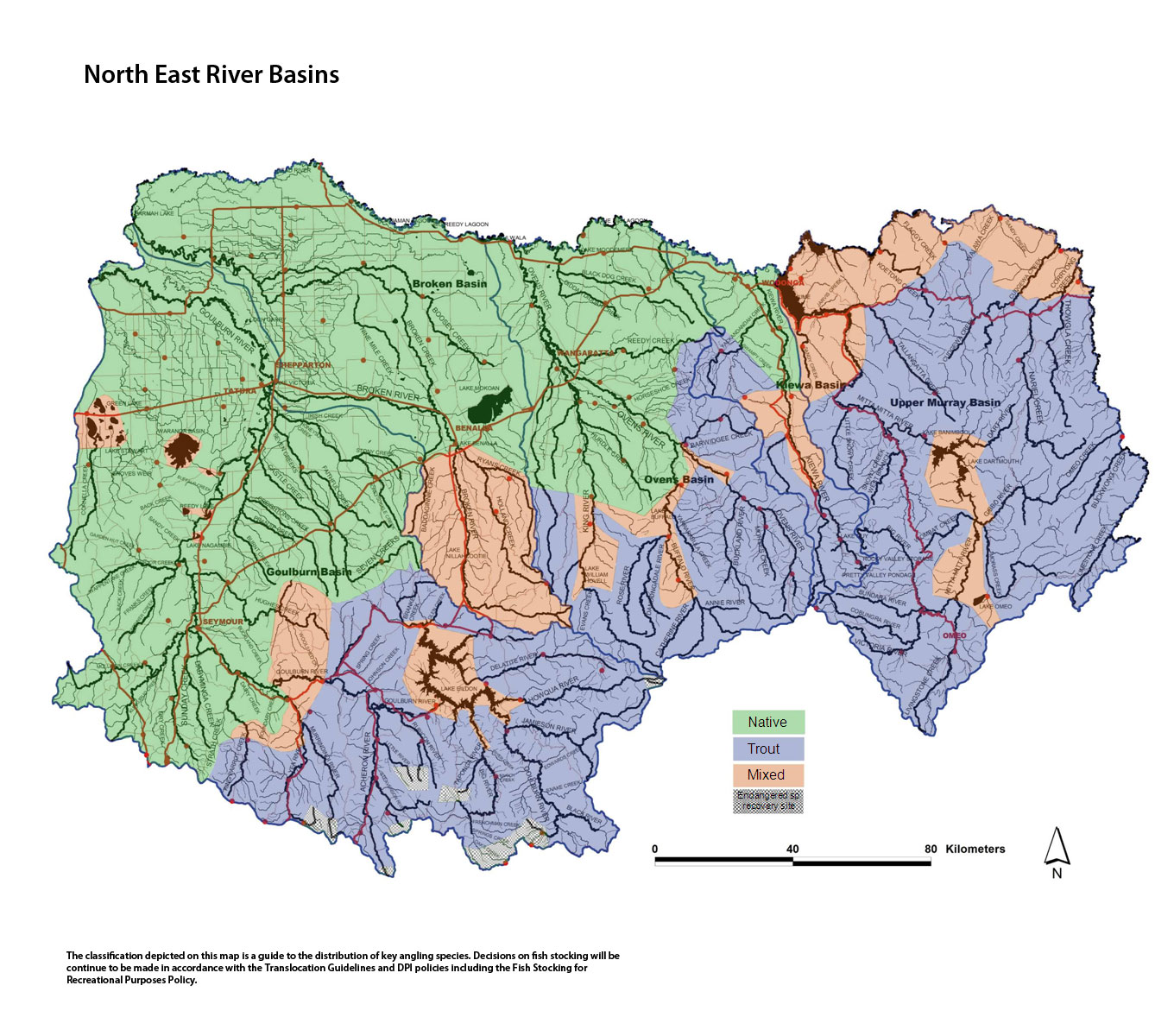
Map showing North East River Basins (click map for large version)
Upper Murray Basin
Preliminary assessment
Species evidence
Murray cod, Murray spiny crayfish, trout cod, blackfish, rainbow trout, brown trout and redfin.
Known range of angling species
Cudgewa Creek downstream of Cudgewa - Murray cod, redfin and brown trout.
Cudgewa Creek upstream of Cudgewa - brown and rainbow trout and blackfish.
Corryong Creek downstream of Colac Colac - brown and rainbow trout, Murray cod, redfin.
Corryong Creek upstream of Colac Colac - brown and rainbow trout.
Thowgla, Nariel, Limestone and Wheelers creeks - brown trout and rainbow trout.
Koetong Creek - brown and rainbow trout, blackfish, redfin.
Lake Hume - redfin, golden perch, brown and rainbow trout, Murray cod.
Waterway management
The North East Regional River Health Strategy guides waterway management and is implemented by the North East Catchment Management Authority in this basin. Activities undertaken through the Strategy include habitat improvement in the Nariel, Koetong and Thowgla creeks.
The Northern Region Sustainable Water Strategy is a plan to secure water supplies for homes, business, industry, agriculture and the environment for the next 50 years. The
Strategy sets out a plan to meet the water needs of towns, industry, farms and the environment in the context of growing populations, the uncertainty of climate change, land use changes and drought.
Natural Catchment Area - Log Bridge Creek.
Threatened fish species
Murray cod, trout cod, alpine spiny crayfish and Murray spiny crayfish. A Governor in Council order allows anglers to take Murray cod and Murray spiny crayfish from waters in this Basin.
Socio-economic value
Cudgewa Creek - brown trout, Murray cod.
Nariel, Thowgla Corryong, Wheelers, Buckwong and Limestone creeks - brown and rainbow trout.
Criteria assessment
Flow
Regulated - Tributaries of the Murray River downstream of Towong.
Unregulated - Tributaries of the Murray River downstream of Towong.
Habitat
All rivers in the north-east edge of this Basin are Murray River tributaries upstream of Lake Hume. The terrain consists of steep hills or mountains with forests south of Corryong and good stream condition and scattered forest and farmland in the north of the Basin. The lower reaches flow in mature valleys with broad alluvial plains. There has been loss of native riparian vegetation because of the introduction of willows, however instream habitat for biota is in good condition. All rivers had very low flows during the past drought years, however fish populations are still intact.
Identifiable structures
Colac Colac, Cudgewa, Murray Valley Highway.
Classification
Trout – Corryong and Cudgewa creeks upstream of Briggs Gap Road. All other Murray River tributaries upstream of the Murray Valley Highway including the Nariel Creek.
Mixed - all waters downstream of the Murray Valley Highway not mentioned elsewhere. Corryong Creek and Cudgewa Creek downstream of Briggs Gap Road. Sandy, Flaggy and Jarvis creeks.
Mitta Mitta Basin
Preliminary assessment
Species evidence
Murray cod, Murray spiny crayfish, Macquarie perch, trout cod, blackfish, rainbow trout, brown trout and redfin.
Known range of angling species
Lake Hume - redfin, golden perch, brown and rainbow trout, Murray cod.
Mitta Mitta and tributaries - Macquarie perch, Murray cod, blackfish, redfin, brown and rainbow trout.
Mitta Mitta upstream of Dartmouth - Macquarie perch.
Lake Dartmouth - Macquarie perch, brown and rainbow trout.
Gibbo River - brown and rainbow trout and blackfish.
Cobungra, Dart and Bundarra rivers - brown and rainbow trout and blackfish.
Waterway management
The North East Regional River Health Strategy guides waterway management and is implemented by the North East Catchment Management Authority in this basin. Activities undertaken through the Strategy include habitat improvement in the Little Snowy Creek at Eskdale, Livingstone Creek, Bundarra Cobungra and the lower Mitta Mitta rivers.
The Northern Region Sustainable Water Strategy is a plan to secure water supplies for homes, business, industry, agriculture and the environment for the next 50 years. The Strategy sets out a plan to meet the water needs of towns, industry, farms and the environment in the context of growing populations, the uncertainty of climate change, land use changes and drought.
Heritage River Area - Mitta Mitta River from Glen Valley to Lake Dartmouth.
Representative Rivers - Upper Big River (above Glen Valley) and Snowy Creek (below Granite Flat) representative rivers of East Victorian dissected uplands.
Natural Catchment Areas - Mount Tabor Creek and Banimboola Creek.
Threatened fish species
Macquarie perch, trout cod, Murray cod, silver perch, alpine spiny crayfish and Murray spiny crayfish. A Governor in Council order allows anglers to take Murray cod and Murray spiny crayfish from waters in this Basin. Macquarie perch may be taken only from Lake Dartmouth and silver perch only from Lake Hume.
Through the National Trout Cod Recovery Program - Trout cod have been stocked into the Mitta Mitta River upstream of Lake Dartmouth.
Socio-economic value
Lake Hume - golden perch, redfin, brown and rainbow trout, Murray cod.
Big River (upper Mitta Mitta River), Morass, Middle, Livingston and Snowy creeks and Gibbo, Dart, Victoria, Bundarra and Cobungra rivers - brown and rainbow trout.
Lake Dartmouth - Macquarie perch, brown and rainbow trout.
Banimboola Lake - brown trout, rainbow trout.
Mitta Mitta River upstream of Lake Dartmouth - brown and rainbow trout.
Mitta Mitta River downstream of Lake Dartmouth - brown trout and Murray cod.
Criteria assessment
Flow
Unregulated - Mitta Mitta River and tributaries from Omeo to Lake Dartmouth.
Regulated - Lake Dartmouth to Eskdale Tailrace to Peters Bridge at Tallandoon.
Regulated - Eskdale to Lake Hume.
Habitat
The Mitta Mitta Basin is mostly steep mountains or hills with extensive forest covering about more than two-thirds of the area. The Mitta Mitta River and tributaries drain into Lake Dartmouth and into a wide valley to Lake Hume. Most of the waterways are in good to excellent condition. Some sections of river bank have been cleared of native vegetation and/or damaged by stock but habitat for aquatic biota is generally very good throughout the Basin.
Cold water released from Lake Dartmouth enhances the suitability of the Mitta Mitta River and tributaries for trout. The Mitta Mitta is a tailrace trout fishery below Lake Dartmouth.
Identifiable structures
Banimboola Lake, Lake Dartmouth, Murray Valley Highway, Lockhardt Creek.
Classification
Trout - All other rivers and creeks upstream of the Murray Valley Highway.
Mitta Mitta River from Lake Dartmouth to Omeo Highway Bridge.
Mixed - Lake Hume, Lockhardt, Sandy, Shady creeks.
Mitta Mitta River (Big River) and tributaries between the Hinnomunjie Bridge crossing and Lake Dartmouth.
Lake Dartmouth and Toke, Murtagh, Soldier, Shady creeks.
Gibbo River from Lake Dartmouth to Corryong Road Bridge.
Mitta Mitta River downstream of Omeo Highway Bridge near Tallandoon.
Kiewa Basin
Preliminary assessment
Species evidence
Murray cod, Murray spiny crayfish, golden perch, trout cod, blackfish, rainbow trout, brown trout and redfin.
Known range of angling species
Kiewa River and tributaries above Dederang including both branches – brown and rainbow trout.
Kiewa River downstream of Keegan's Bridge Dederang to the Murray River - Murray cod, brown and rainbow trout.
Allans Flat Dredge Hole - rainbow trout and golden perch.
Mount Beauty Pondage - redfin, brown and rainbow trout.
Pretty Valley Pondage – brown trout. Rocky Valley Reservoir and Lake Guy – brown and rainbow trout.
Yackandandah Creek - brown and rainbow trout, Murray spiny crayfish and redfin.
Waterway management
The Kiewa River downstream of Mount Beauty Pondage is a Premier River because it can provide high quality, accessible and sustainable fishing for developing and experienced anglers. The Kiewa River was selected to be developed and promoted as a Premier River through the Go Fishing in Victoria initiative to enhance the social and economic contribution of fishing to Victorian communities.
Cold water released from Mount Beauty Pondage enhances the suitability of the river and tributaries for trout. The Kiewa River is a tailrace trout fishery below Mount Beauty pondage.
The North East Regional River Health Strategy guides waterway management and is implemented by the North East Catchment Management Authority in this basin. Activities undertaken through the Strategy include determining the sustainable limit of water use in the catchment, negotiating an environmental flow for the Kiewa River and habitat improvement works in the Kiewa River and Yackandandah Creek.
The Northern Region Sustainable Water Strategy is a plan to secure water supplies for homes, business, industry, agriculture and the environment for the next 50 years. The Strategy sets out a plan to meet the water needs of towns, industry, farms and the environment in the context of growing populations, the uncertainty of climate change, land use changes and drought.
Threatened fish species
Murray cod, trout cod, alpine spiny crayfish and Murray spiny crayfish. A Governor in Council order allows anglers to take Murray cod and Murray spiny crayfish from waters in this Basin.
Socio-economic value
Kiewa River downstream of Mount Beauty Pondage - brown and rainbow trout.
West and East Kiewa rivers and tributaries – brown and rainbow trout.
Kiewa River downstream of Dederang to the Murray River - Murray cod and brown trout.
Mount Beauty Pondage, Lake Guy (Junction Dam), Rocky Valley Reservoir and, Pretty Valley Pondage - brown and rainbow trout.
Criteria assessment
Flow
Unregulated - west branch of Kiewa River at the end of Simmonds Creek Road Weir.
Regulated - all other waters.
Habitat
The Kiewa starts in forest in the Alpine National Park and flows through farmland with the valley widening in the lower reaches until it flows into the Murray River, downstream of Lake Hume. Half the Basin is forested or with alpine vegetation and the rivers have excellent instream habitat.
Water temperatures in the Kiewa are coldest above Mount Beauty Pondage; cool from the Pondage to House Creek; and warming towards the Murray River.
Identifiable structures
Rocky Valley Storage, Lake Guy, Clover Dam, Mount Beauty Pondage.
Classification
Trout - Kiewa River and all tributaries upstream of Mongans Bridge, Yackandandah Creek upstream of Osbournes Flat Road. Running Creek and tributaries.
Mixed - Kiewa River from Mongans Bridge to Gundowring Bridge.
Native - Kiewa River downstream of Gundowring Bridge. Wodonga, Middle, Huon and House creeks.
Ovens Basin
Preliminary assessment
Species evidence
Macquarie perch, Murray cod, golden perch, blackfish, trout cod, redfin, brown and rainbow trout.
Known range of angling species
Barwidgee, Fifteen Mile, Morses, Boggy creeks - brown and rainbow trout, blackfish, redfin,
Ovens, King, Dandongadale, Rose, Buckland and Catherine rivers and Barwidgee, Hurdle, Happy Valley, Fifteen Mile and Boggy creeks - brown and rainbow trout, blackfish, redfin, Murray spiny crayfish.
King River downstream of Edi - brown, rainbow trout, redfin blackfish, golden perch, Murray cod.
Ovens River downstream of Myrtleford - Murray cod, golden perch, Murray spiny crayfish, blackfish, Murray River rainbowfish.
Buffalo River above Lake Buffalo - brown and rainbow trout, blackfish, redfin, Murray spiny crayfish, Macquarie perch.
Buffalo River below Lake Buffalo - brown and rainbow trout, redfin, blackfish, golden perch, Murray cod, Macquarie perch, Murray spiny crayfish.
Waterway management
The North East Regional River Health Strategy guides waterway management and is implemented by the North East Catchment Management Authority in this basin. Activities undertaken through the Strategy include bank revegetation, willow removal and improved water flow on the Ovens and King rivers and Fifteen Mile and Happy Valley creeks.
The Northern Region Sustainable Water Strategy is a plan to secure water supplies for homes, business, industry, agriculture and the environment for the next 50 years. The Strategy sets out a plan to meet the water needs of towns, industry, farms and the environment in the context of growing populations, the uncertainty of climate change, land use changes and drought.
Heritage River - Ovens River from Killawarra to Lake Mulwala.
Natural Catchment Areas - Yarrarabula Creek and Long Jack Creek (two upper Buffalo River tributaries) and Devils Creek-Middle Branch (a tributary of the Buckland River).
Threatened fish species
Trout cod, silver perch, catfish, Macquarie perch, Murray cod, Murray River rainbowfish, Murray spiny crayfish.
A Governor in Council order allows anglers to take Murray cod and Murray spiny crayfish from waters in this Basin.
Socio-economic value
Ovens River and tributaries upstream of Myrtleford - brown trout, rainbow trout.
Ovens River and tributaries downstream of Myrtleford to Lake Mulwala - Murray cod, golden perch.
King River upstream and downstream of Lake William Hovell - brown and rainbow trout.
Lake William Hovell – brown and rainbow trout, blackfish, Macquarie perch.
Buffalo River and tributaries upstream of Lake Buffalo - brown and rainbow trout.
Buffalo River and tributaries downstream of Lake Buffalo - brown and rainbow trout and blackfish, Murray cod, Murray spiny crayfish.
Criteria assessment
Flow
Unregulated – Ovens River above Myrtleford, King River upstream of William Hovell, Buffalo River above Lake Buffalo.
Regulated – Ovens River downstream of Myrtleford, King River downstream William Hovell to Wangaratta, and Buffalo River below Lake Buffalo.
Habitat
The Ovens Basin extends from high altitude forested mountains in the Great Dividing Range to the Murray River at Lake Mulwala. Almost two-thirds of the Basin (south of Wangaratta) has steep mountains and hills and most of this is covered with forests. The main rivers (Ovens, Buffalo, Buckland and King) flow in wide valleys of cleared farmland.
Cold water flows from alpine areas flows above Burgoigee Creek and from William Hovell to Edi. Water warms from Edi to Moyhu.
Identifiable structures
Lake William Hovell, Eurobin, Harrietville Dredge Hole, Ovens River junction with Myrtleford River, Whitfield Road, Buffalo Camp Creek junction, Lake Buffalo.
Classification
Trout - Ovens River and tributaries upstream of Eurobin.
Rose and Dandongadale rivers.
Ovens River tributaries downstream of Myrtleford (junction of Buffalo River) upstream of Woolshed Falls, Fifteen Mile and Boggy creeks upstream of Whitfield Road Benalla.
Buffalo River upstream of junction with Camp Creek.
Buckland River and tributaries.
King River above Lake William Hovell.
Mixed - William Hovell, Buffalo, Sambell and Kerford lakes.
King River below Lake William Hovell to Edi.
Harrietville Dredge Holes.
Ovens River from Eurobin to Myrtleford (junction of Buffalo River).
Buffalo River from Lake Buffalo to Camp Creek Junction.
Buffalo River below Lake Buffalo.
Native - Ovens River and tributaries below Myrtleford.
Hurdles, Horshoe, Didda Didda, Reedy, Black Dog creeks.
King River below Edi.
Goulburn Basin
Preliminary assessment
Species evidence
Rainbow trout, brown trout, blackfish, golden perch, freshwater catfish, Murray cod, Macquarie perch, redfin, trout cod, silver perch, spiny freshwater crayfish.
Known range of angling species
Rainbow trout, brown trout, blackfish, Murray cod.
Goulburn River (above Lake Eildon) - rainbow trout, brown trout.
Delatite River - upper reaches brown and rainbow trout, lower reaches also blackfish, and spiny freshwater crayfish and Murray cod.
Howqua, Acheron, Royston, Rubicon, Big and Taponga rivers and Home and Gaffneys creeks - brown trout, rainbow trout, blackfish, redfin.
Murrindindi, Yea rivers - brown trout, blackfish, redfin, Macquarie Perch and spiny freshwater crayfish (Murrindindi River).
Goulburn River upstream from Seymour - brown and rainbow trout, Murray cod, trout cod, golden perch, Macquarie perch, redfin and blackfish.
Goulburn River upstream from Molesworth to Eildon - brown and rainbow trout, redfin and blackfish.
Goulburn River from Goulburn Weir to Shepparton - Murray cod, golden perch, trout cod, redfin, catfish, blackfish, silver perch, Macquarie perch, brown trout.
Goulburn River from Shepparton to the Murray River - Murray cod, golden perch, blackfish, catfish, silver perch. redfin, Macquarie perch, trout cod, brown trout.
King Parrot and Hughes creeks - blackfish, Macquarie perch, brown and rainbow trout.
Jamieson River - Macquarie perch, blackfish, redfin, brown and rainbow trout.
Sugarloaf Creek - brown trout, redfin.
Sunday Creek - blackfish, Murray cod, redfin.
Major's creek - blackfish, Murray cod, golden perch, redfin.
Goulburn Weir Pool from the Weir to Hughes Creek - Murray cod, golden perch, redfin, blackfish, catfish, spiny freshwater crayfish.
Seven Creeks upstream of Polly McQuins - Macquarie perch, redfin, brown trout.
Seven Creeks from Polly McQuins to Galls Gap bridge - trout cod, redfin, and brown trout.
Seven Creeks downstream of Galls Gap bridge - Macquarie perch, blackfish.
Seven Creeks downstream of Euroa - golden perch, redfin, blackfish.
Waranga Basin - brown trout, redfin, golden perch, Murray Cod, spiny freshwater crayfish.
Greens Lake (Corop) - redfin, golden perch.
Waterway management
The Goulburn River from Eildon Pondage to Alexandra and from Murchison to Loch Garry is a Premier River because it can provide high quality, accessible and sustainable fishing for developing and experienced anglers. The Goulburn River was selected to be developed and promoted as a Premier River through the Go Fishing in Victoria initiative to enhance the social and economic contribution of fishing to Victorian communities.
The Goulburn Broken Regional River Health Strategy guides waterway management and is implemented by the Goulburn Broken Catchment Management Authority in this basin. Activities undertaken through the Strategy include habitat improvement works on the Delatite, Howqua, upper Goulburn, Rubicon and Jamieson rivers, the Goulburn River downstream of the Pondage and the King Parrot and Seven creeks.
The Northern Region Sustainable Water Strategy is a plan to secure water supplies for homes, business, industry, agriculture and the environment for the next 50 years. The Strategy sets out a plan to meet the water needs of towns, industry, farms and the environment in the context of growing populations, the uncertainty of climate change, land use changes and drought.
Heritage River Areas - Goulburn River (from Lake Eildon to the Murray River), the Howqua River (from the junction of the north and south branches to Lake Eildon), and the Big River (from the junction of Spring and Oaks creeks to the junction of Fryer Creek and Big River Arm at Lake Eildon).
Representative Rivers - Cornella Creek is representative of the East Victorian dissected uplands, riverine plains.
Natural Catchment Area - Williams Creek on the Upper Goulburn River.
Threatened fish species
Murray cod, Macquarie perch, Murray hardyhead, Murray River rainbowfish, trout cod, freshwater catfish, flathead galaxias, barred galaxias, silver perch and Murray spiny crayfish. A Governor in Council order allows anglers to take Murray cod and Murray spiny crayfish from waters in this Basin.
Headwater streams of the Howqua, Rubicon, Torbreck, Acheron, Yea and Goulburn rivers contain barred galaxias (Galaxias fuscus). Headwater streams of the upper Taponga River contain a population of the threatened spotted tree frog (Litoria spenceri)
Socio-economic value
Lake Eildon - brown and rainbow trout, redfin, Murray cod, golden perch.
Lake Eildon is a Premier Lake which is regularly stocked with large rainbow trout to provide opportunities for those new to fishing to try their luck
Eildon Pondage - brown and rainbow trout, Murray spiny crayfish.
Goulburn River Pondage to Alexandra - brown trout, rainbow trout.Goulburn River downstream of Shepparton - Murray cod, golden perch, Murray spiny crayfish.
Goulburn River from Alexandra to Seymour - brown and rainbow trout.
Goulburn River from Seymour to Nagambie - Murray cod, redfin, spiny freshwater crayfish, golden perch.
All Lake Eildon tributaries – brown and rainbow trout.
Rubicon River and tributaries – brown and rainbow trout.Acheron River and tributaries – brown and rainbow trout.
Murrundindi River – brown and rainbow trout.
King Parrot Creek – brown and rainbow trout.
Criteria assessment
Flow
Unregulated - Goulburn tributaries and rivers and streams upstream of Lake Eildon.
Regulated - Eildon Pondage to Alexandra, Goulburn Weir to the Murray.
Habitat
The Goulburn Basin extends from steep hills northward into the Murray Plain. Much of the basin is forested with clear, cold and fast flowing rivers with gravel and rubble substrates. Further north the Basin has been cleared for farmland with isolated patches of forest and an area of intensive irrigation and cropping north of Waranga Reservoir. Water quality is excellent for aquatic biota.
Identifiable structures
Lake Eildon, Goulburn Weir, Eildon Pondage, Mansfield-Jamieson Road, Mitchells Track, Seymour, Trawool, Murray River, Galls Gap Bridge, Poly McQuinn, Flowerdale-Yea Road, Waranga Basin, Shepparton, Casey's weir, Gowangardie Weir.
Classification
Trout - Goulburn River and tributaries upstream of Molesworth to Eildon.
King Parrot Creek upstream of Flowerdale.
Eildon Pondage.
Delatite, Howqua, Jamieson, Big, Taponga, Rubicon, Acheron, Steavenson rivers and tributaries.Murrindindi River upstream from Devlin's Bridge area.
Goulburn River above Lake Eildon.
All other Lake Eildon tributaries not mentioned elsewhere.
Mixed - Goulburn River upstream from Yea River to Molesworth Bridge.
Howqua River downstream from the Mansfield-Jamieson Road Bridge.Jamieson River downstream from Jamieson
Lake Eildon and Goulburn Weir.
Yea River downstream of Devlin's Bridge.
Murrindindi River downstream of Devlin's Bridge.
King Parrot Creek, downstream of Flowerdale to Strath Creek.
Hughes Creek upstream of Tarcombe.
Delatite River downstream of Mansfield-Jamieson Road and Jamieson River downstream of Mitchells Track.
Native - Goulburn River from Yea River to the Murray.
Seven Creeks from the Goulburn to Galls Gap Bridge.
King Parrot Creek, downstream of Strath Creek.
Sunday Creek, Mollisons Creek and tributaries.
Majors Creek and all other waters downstream of Seymour not mentioned elsewhere.
Some small headwater streams of the Howqua, Goulburn, Rubicon, Taponga, Acheron, Torbreck and Yea rivers and Hughes Creek in recognition of threatened species (see map).
Broken Basin
Preliminary assessment
Species evidence
Golden perch, Murray cod, trout cod, redfin, blackfish, brown trout, rainbow trout.
Known range of angling species
Nillahcootie Lake - redfin, golden perch, Murray cod, trout, blackfish.
Broken River downstream of Benalla Weir - golden perch, Murray cod and redfin.
Broken River downstream of Nillahcootie to Benalla and Ryans Creek upstream of McCall Say Weir - brown trout.
Upper Hollands creek - brown and rainbow trout and redfin.
Ryans creek - Macquarie perch.
Lima Creek - brown trout.
Lima East Creek - brown and rainbow trout.
Waterway management
The Goulburn Broken River Health Strategy guides waterway management and is implemented by the Goulburn Broken Catchment Management Authority. The Authority undertakes activities including construction of fishway at Casey's Weir on the Broken River. A 'Demonstration Reach' has been set up in Hollands Creek.
The Northern Region Sustainable Water Strategy is a plan to secure water supplies for homes, business, industry, agriculture and the environment for the next 50 years. The Strategy sets out a plan to meet the water needs of towns, industry, farms and the environment in the context of growing populations, the uncertainty of climate change, land use changes and drought.
Ramsar - Barmah State Park and its associated waterways and wetlands including Barmah Lakes, Murray River from Tocumwal to Barmah and the lower 5km reach of the Broken Creek.
Threatened fish species
Freshwater catfish, flathead galaxias, Macquarie perch, Murray cod, trout cod, Murray River rainbowfish, and Murray spiny crayfish. Murray cod and Murray spiny crayfish may be taken by anglers under a Governor in Council order.
Socio-economic value
Nillahcootie Lake - redfin golden perch, Murray cod.
Broken River Mansfield - brown trout.
Broken River Casey's Weir - Murray cod, golden perch
Boosey and Broken Creek downstream of Nathalia - Murray cod, golden perch.
Broken River downstream of Nillahcootie to Benalla and Ryans Creek upstream of McCall Say Weir - brown trout.
Hollands Creek upstream of the junction with Ryans Creek - brown and rainbow trout and redfin.
Criteria assessment
Flow
Regulated.
Habitat
The Broken Basin consists mainly of flat farmland with sloping gentle hills. The Broken River drains from steep forested hills south of Benalla through flat farmland to the Goulburn River at Shepparton. Downstream of Benalla, the Broken Creek branches off from the Broken River and flows to the Murray River near Barmah.
Gravel and rubble substrates are restricted to the upper reaches of the Broken River with the remainder of the river substrates comprised of mud and sand substrate. Healthy riparian vegetation, instream snags and fish cover in permanent pools are common, but periods of low flow occur during spring.
Identifiable structures
Lake Nillahcootie, Ryans Creek, McCall Say Weir, Loombah Weir (Ryans Creek).
Classification
Trout - Ryans Creek upstream of McCall Say Weir and between Loombah Weir and Ryans Creek township. Upper Hollands Creek.
Mixed - Lake Nilahcootie, lower Hollands Creek, lower Ryans Creek below and including Loombah Weir, Baddaginnie Creek, Broken River south of Benalla.
Native - Ryans Creek between McCall Say and Loombah weirs and all other waters including Broken River north of Benalla.