Gippsland Region
The Gippsland region encompasses the Snowy, Tambo, Mitchell, La Trobe, Thomson and South Gippsland basins. Popular angling species include brown and rainbow trout, redfin, black bream, estuary perch, Gippsland spiny crayfish, blackfish, eel, Australian bass and a range of other estuarine species.
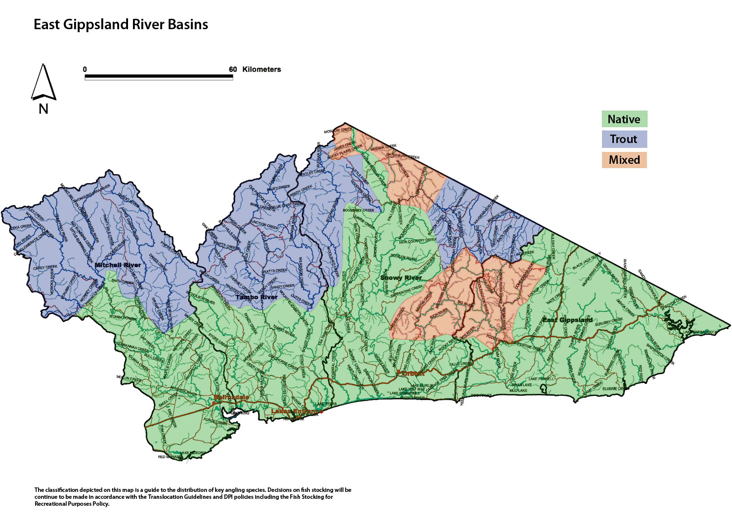
Map showing East Gippsland River Basins (click map for large version)
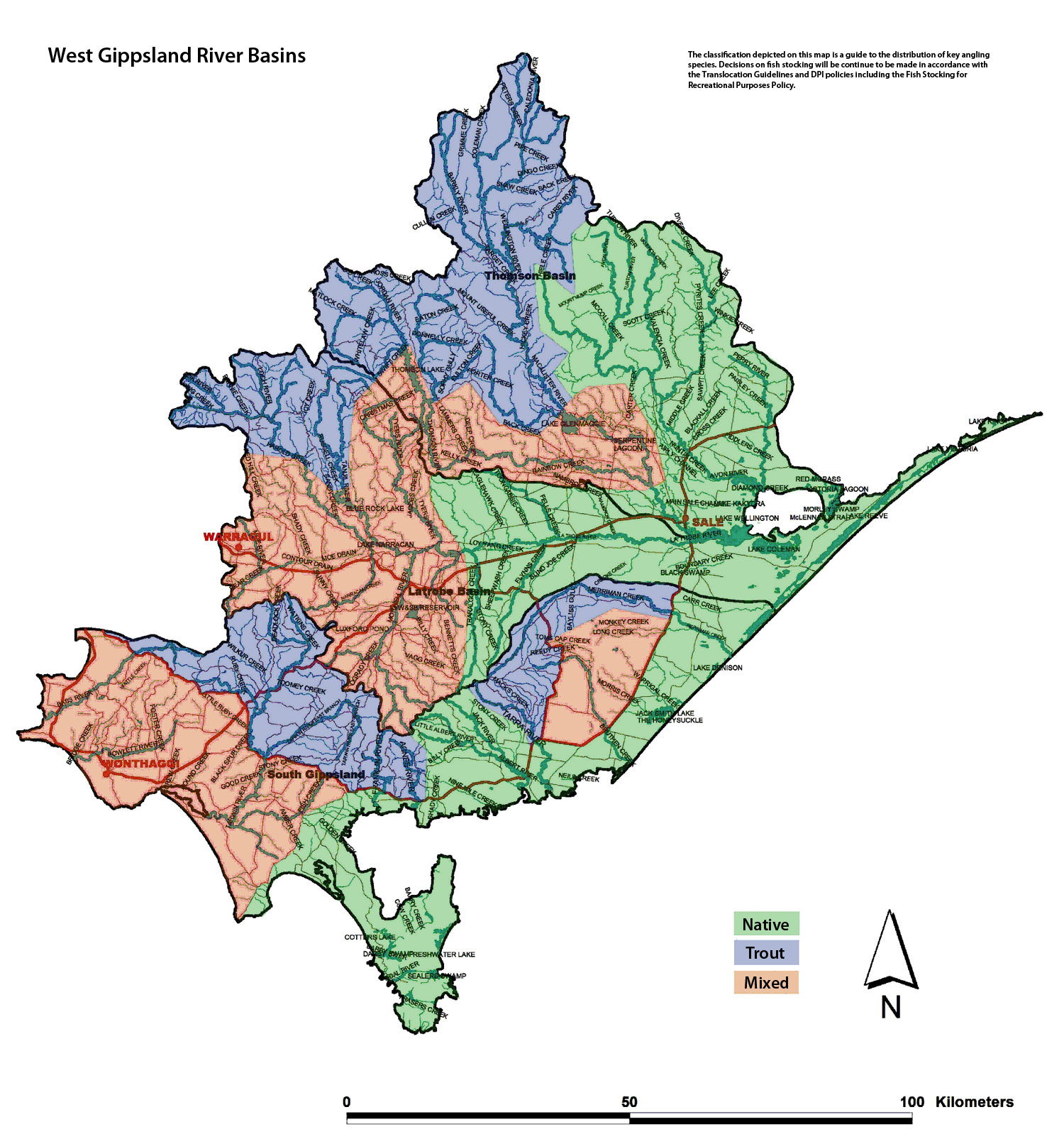
Map showing West Gippsland River Basins (click map for large version)
East Gippsland Basin
Preliminary assessment
Species evidence
Australian bass, estuary perch, brown and rainbow trout, redfin, Gippsland spiny crayfish, river blackfish, luderick, mullet, longfin eel, southern shortfin eel.
Known range of angling species
Genoa and Bemm Rivers - Australian bass, black bream.
Bemm River - Australian bass, black bream, Gippsland spiny crayfish, blackfish, estuary perch and brown trout.
Combienbar, Errinundra and Goolengook rivers - brown trout.
Little, Betka, Benedore, Cann (east and west branch), Genoa, Mueller, McKenzie, Red, Thurra, Wingan, and Wallagaraugh rivers - Australian bass. In the estuarine reaches, black bream, estuary perch, flathead, luderick, mullet, trevally, garfish, tailor and sometimes mulloway.
The East Gippsland spiny crayfish is restricted to a few small tributaries in this Basin.
Waterway management
Heritage Rivers - Genoa, Bemm, Goolengook (from its headwaters), Arte (from Glen Aire Road) and Errinundra rivers (from headwaters of east branch; upper reaches to the sea).
Representative Rivers of East Victorian dissected uplands and riverine plains - Thurra River.
Natural Catchment Areas - Red and Benedore rivers and Shipwreck, Seal and Easby creeks in the Croajingalong National Park, an area on Double Creek, an un-named tributary of Genoa River and an area of Winnot Creek.
UNESCO Biosphere Reserve - Croajingalong Park.
The East Gippsland Catchment Management Authority manages the waterways in the region through the East Gippsland River Health Strategy and undertakes activities including fencing, revegetation, stabilisation of beds and banks, willow removal, reinstating fish habitat such as deep water and snags. Major activities are willow control, and re-vegetation and protection of banks and work has been carried out in the Bemm, Cann, Combienbar, Errinundra, Genoa, Wallagaraugh and Wingan Rivers.
The Gippsland Region Sustainable Water Strategy is currently in preparation and will respond to pressures facing water resources including climate change, drought, and land use change. The strategy aims to secure water for towns, industry, the environment and agriculture for the next 50 years.
Threatened fish species
Australian grayling, Cox's gudgeon, empire gudgeon, freshwater herring, striped gudgeon, Eastern freshwater prawn, East Gippsland spiny crayfish, Clayton's spiny crayfish and variable spiny crayfish.
Socio-economic value
Waters valued for angling for trout include - Bemm, Combienbar, Errinundra and Goolengook rivers.
Waters valued for angling for native species include - Bemm, Betka, Cann, Genoa, Little, Wallgaraugh, Mueller, McKenzie and Thurra rivers and the Tamboon, Wingan and Sydenham inlets.
Criteria assessment
Flow
Unregulated flow – all.
Habitat
The Basin is mostly steep mountains and hills of granitic, sedimentary and volcanic origin. There is a small coastal strip (Bemm to Cann River) of flat farmland and dunes. Most of the Basin is covered with mixed-species forest with stands of tall forest in the northwest.
Identifiable structures
Princes Highway.
Classification
Mixed - Goolengook, Arte, Errinundra and Combienbar and tributaries.
Native - Little, Betka, Bemm, Benedore, Cann (east and west branch), Genoa, Mueller, McKenzie, Red, Thurra, Wingan, and Wallagaraugh rivers and tributaries. Yeerung River East and West branches.
Snowy Basin
Preliminary assessment
Species evidence
Brown and rainbow trout, redfin Australian bass, estuary perch, Gippsland spiny crayfish, river blackfish, longfin eel and southern shortfin eel.
Known range of angling species
Bonang, Brodribb, Buchan, Bendoc, Rodger, Delegate and Little rivers and their tributaries - brown trout and blackfish.
Queensborough River - brown trout and blackfish.
Snowy, Brodribb, Suggan Buggan, Buchan Yalmy, Murrindal, Mountain and Rodger rivers and Cabbage Tree Creek - Australian bass, brown trout.
Snowy River upstream of Suggan Buggan River junction - brown trout and Australian bass.
Upper Suggan Buggan, Brodribb, Buchan rivers and Mountain Creek – brown trout, Gippsland spiny crayfish.
Waterway management
The Snowy River is currently undergoing an environmental improvement program involving provision of increased environmental flows; protection and restoration of riparian habitat by removal of willows and weeds, planting native vegetation and fencing out stock; and trials to restore in-stream habitat such as deeper water and snags. It also involves re-establishing Australian Bass in the Snowy River.
Heritage River - the Snowy River, the Suggan Buggan and lower Berrima rivers and the upper reaches of the Buchan River (Playgrounds to Campbell Creek).
Representative River of East Victorian dissected uplands Buchan River (above Mellick Creek).
Natural Catchment Areas - Gattamurh, Wallaby, Mountain, Mount Gelantipy, Musk creeks and the headwaters of the Brodribb and Rodger rivers.
The East Gippsland Catchment Management Authority manages the waterways in the region through the East Gippsland River Health Strategy. The Authority undertakes activities including habitat restoration activities such as fencing, revegetation, stabilisation of beds and banks, willow removal, reinstating fish habitat such as deep water and snags. Work has been carried out in the Brodribb, Buchan, Murrindal and Snowy Rivers.
The Gippsland Region Sustainable Water Strategy is currently in preparation and will respond to pressures facing water resources including climate change, drought, and land use change. The strategy aims to secure water for towns, industry, the environment and agriculture for the next
50 years.
Threatened fish species
Australian grayling, alpine spiny crayfish, Orbost spiny crayfish, Cox's gudgeon, striped gudgeon, Eastern freshwater prawn, East Gippsland spiny crayfish.
Socio-economic value
Waters valued for angling for trout include - Bonang, Brodribb, Buchan, Delegate, Queensborough and Little rivers.
Waters valued for angling for mixed species such as blackfish, Australian bass and trout include - Buchan, Queensborough, Rodger, Brodribb, Murrindal rivers and Mountain Creek.
Waters valued for angling for native species include – the Queensborough, Buchan, Rodger and Snowy rivers and the Snowy River estuary.
Criteria assessment
Flow
Regulated - Flow in the Snowy River is controlled by water released from the Jindabyne Reservoir in NSW. More recently environmental flows have been increased and flow is more suitable for angling species. Natural inflow from tributaries further downstream have maintained instream conditions in the middle and lower reaches of the Snowy River.
Habitat
Improved environmental flow releases aim to restore flow to a higher percentage of the natural mean annual flow. A proposal to restore original instream habitat, including deep pools is in place.
Identifiable structures
Snowy River Road and Suggan Buggan, McKillops Road and Bridge, Princes Highway, Wulgulmerang, Tubbut, and Rocky River Road crossing of Brodribb River.
Classification
Trout - Bendoc, Bonang, Delegate, Ingeegoodbee and Queensborough rivers and tributaries. Deddick River upstream of Tubbut. Buchan River upstream of Frying Pan Creek.
Mixed - Suggan Buggan River tributaries upstream of Suggan Buggan, Brodribb River upstream of Rocky River Road, Little River. Wombargo, Goodwin, Jamb, Amboyne, Tingaringy and Wulgulmerang creeks. Snowy River upstream of Suggan Buggan River junction.
Native - Suggan Buggan River, Rodger, Yalmy, Rocky, Jack and lower Brodribb rivers and tributaries. Cabbage Tree, Boundary, Butchers, Currie, Mountain and Hospital creeks. Buchan River downstream of Frying Pan Creek and Snowy River downstream of Suggan Buggan.
Tambo Basin
Preliminary assessment
Species evidence
Australian bass, estuary perch, Gippsland spiny crayfish, longfin eel, river blackfish and southern shortfin eel, brown and rainbow trout.
Known range of angling species
Tambo River and tributaries upstream of Tambo Crossing - brown trout and river blackfish.
Tambo River upstream of Ensay - rainbow trout.
Tambo River from Tambo Crossing to Tambo Bay - Australian bass, black bream, estuary perch.
Timbarra River and Haunted Stream - brown and rainbow trout and river blackfish.
Nicholson River - river blackfish.
Waterway management
The East Gippsland Catchment Management Authority manages the waterways in the region through the East Gippsland River Health Strategy. The Authority undertakes activities including habitat restoration activities such as fencing, revegetation, stabilisation of beds and banks, willow removal, reinstating fish habitat such as deep water and snags, and building fishways and fishing platforms.
The Gippsland Region Sustainable Water Strategy is currently in preparation and will respond to pressures facing water resources including climate change, drought, and land use change. The strategy aims to secure water for towns, industry, the environment and agriculture for the next 50 years.
Threatened fish species
Australian grayling, eastern freshwater prawn, Cox's gudgeon, striped gudgeon.
Socio-economic value
Waters valued for angling for trout include - Tambo and Little rivers, Haunted Stream and 'Timbarra Rivers upstream of Mt Elizabeth Creek.
Waters valued for angling for native species include - Nicholson River, Tambo River downstream of Ensay and Timbarra River downstream of Mt Elizabeth Creek.
Criteria assessment
Flow
Unregulated – mostly natural, but some streams have irrigation extraction and there is a dam on the Nicholson River.
Habitat
The major rivers of the Tambo River basin are the Tambo and Nicholson Rivers. The principal tributary of the Tambo River is the Timbarra River. The Tambo and Timbarra have reliable flow but the Nicholson River often ceases to flow in summer.
The basin is mostly covered by steep forested mountains. There is a small southern section of farmland and another in the middle to upper reaches of the Tambo River.
Identifiable structures
Ensay, Tambo Crossing, junction of Tambo River and Haunted Stream and Tambo River and Timbarra River. Junction of Mt Elizabeth Creek and Timbarra River, Shady Creek.
Classification
Trout - Tambo River and tributaries upstream of and including Haunted Stream. Little River. Timbarra River upstream of Mt Elizabeth Creek. Shady and Stony creeks.
Native - Tambo River and tributaries downstream of Haunted Stream. Nicholson River.
Mitchell Basin
Preliminary assessment
Species evidence
Australian bass, estuary perch, longfin eel, river blackfish southern shortfin eel, brown and rainbow trout.
Known range of angling species
Wonnangatta and Wongungarra rivers and tributaries. Dargo, Crooked, Humfray and Wentworth rivers - brown trout and river blackfish.
Mitchell River - Australian bass, brown trout.
Mitchell River estuary - Australian bass, brown trout, estuary perch, black bream.
Waterway management
Heritage Rivers - Wonnangatta River and the Mitchell River (Wonnangatta headwaters to Lake King).
Natural Catchment Area - small areas of Pinnacle, Blue Rag Creek and Punchen Creeks and the Wongungarra River headwaters.
The East Gippsland Catchment Management Authority manages the waterways in the region through the East Gippsland River Health Strategy. The Authority undertakes activities including habitat restoration activities such as fencing, revegetation, stabilisation of beds and banks, willow removal, reinstating fish habitat such as deep water and snags, and building fishways and fishing platforms.
The Gippsland Region Sustainable Water Strategy is currently in preparation and will respond to pressures facing water resources including climate change, drought, and land use change. The strategy aims to secure water for towns, industry, the environment and agriculture for the next 50 years.
Threatened fish species
Australian grayling, dwarf galaxias, striped gudgeon, Cox's gudgeon, eastern freshwater prawn.
Socio-economic value
Waters valued for angling for trout include - Wonnangatta, Humffray, Wongungarra, Mitchell, Crooked, Dargo, Moroka and Wentworth rivers.
Waters valued for angling for native species include - Mitchell River and tributaries.
Criteria assessment
Flow
Unregulated flow – some streams have irrigation extraction, but flow remains natural.
Habitat
The Mitchell is the largest free flowing river in Victoria with no barriers to native fish movement or major water diversions affecting natural flows.
The major headwaters for the Mitchell River are the Wonnangatta and Wongungarra Rivers. They are large waterways with usually reliable high annual flow. Most of the basin has steep mountains or hills covered in dense native forest with the exception of a small coastal strip of farmland. The Mitchell River flows through cliffs and several gorges, including the Den of Nargun.
Identifiable structures
Dargo and Tabberabbera.
Junction of Mitchell, Wonnangatta and Wongungarra rivers.
Classification
Trout - Wonnangatta, Wongungarra, Humffray, Dargo and Wentworth rivers and tributaries upstream of the junction with the Mitchell River.
Native - Mitchell River downstream of the junctions with Wongungarra, Dargo and Wentworth rivers.
Thomson Basin
Preliminary assessment
Species evidence
Brown trout, rainbow trout, redfin Australian bass, estuary perch, Gippsland spiny crayfish, longfin eel, river blackfish and southern shortfin eel.
Known range of angling species
Brown trout, rainbow trout, Australian bass, estuary perch, Gippsland spiny crayfish, longfin eel, river blackfish and southern shortfin eel.
Thomson River and tributaries including Thomson Reservoir - brown and rainbow trout
Macalister River and tributaries (including Lake Tali Karng) above Lake Glenmaggie - brown and rainbow trout, river blackfish, Australian bass, Gippsland spiny crayfish and redfin.
Macalister River and tributaries below and including Lake Glenmaggie - Australian bass, brown trout.
Thomson and Aberfeldy rivers – Australian bass.
Macalister River below Glenmaggie – Australian bass.
Macalister below Maffra becomes less suitable for trout and the primary angling species is Australian bass. Other angling species present include redfin and shortfin eel.
Waterway management
Heritage River - Thomson River (downstream of Thomson Reservoir to Cowwarr Weir) and the Aberfeldy River (in the Baw Baw National Park).
Natural Catchment Areas - upper reaches of the Avon River including Turton and Dolodrook Rivers and Ben Cruachan Creek.
Representative Rivers - upper reaches of the Macalister River at Glencairn for East Victorian uplands, dissected plateau.
The West Gippsland Catchment Management Authority manages the waterways in the region through the West Gippsland River Health Strategy. The Authority undertakes activities including habitat restoration activities such as fencing, revegetation, stabilisation of beds and banks, willow removal, reinstating fish habitat such as deep water and snags, and building fishways and fishing platforms.
The Central Region Sustainable Water Strategy is a plan to respond to pressures facing water resources including climate change, drought, and land use change. The Strategy aims to secure water for towns, industry, the environment and agriculture for the next 50 years.
Threatened fish species
Australian grayling, Dwarf galaxias, Baw Baw frog, Curve-tail burrowing cray.
Socio-economic value
Waters valued for angling for trout include - Macalister, Aberfeldy, Wellington, Caledonia, Barkly rivers and Rainbow Creek.
Waters valued for angling for mixed species include - Lake Glenmaggie and the Macalister River downstream to the junction of Thomson. The Thomson River from the junction of the Macalister upstream to Thomson Reservoir.
Waters valued for angling for native species include - the Macalister River downstream of the junction with the Thomson and the Avon River and tributaries.
Criteria assessment
Flow
Unregulated – upstream of Lake Glenmaggie and Thomson Reservoir.
Regulated – downstream of Lake Glenmaggie and Thomson Reservoir.
Habitat
The headwaters of the Macalister above Lake Glenmaggie have extensive deep pools and fast runs, rock and rubble bottom. Downstream from Licola, the gradient decreases and the river becomes wider and slower. Near Mt Useful Creek the river flows through farmland with riparian vegetation of grass and willows on one bank and forest on the other bank. Wide pools separated by substantial riffles. Substrate is rock, rubble and gravel. Further downstream, the banks are more eroded resulting in the pools becoming filled with sediment. There are wide fluctuations in flow and water level and very high turbidity during floods.
Identifiable structures
Lake Glenmaggie, Stratford-Maffra Road, Thomson-Macalister river junction.
Classification
Trout - above Lake Glenmaggie and Thomson Reservoir, Aberfeldy River and tributaries.
Mixed – Thomson River downstream of Thomson Reservoir and Macalister Reservoir downstream of Lake Glenmaggie.
Native - Junction of the Thomson and the Macalister rivers to 'Lake Wellington. Avon and Perry rivers and tributaries.
La Trobe Basin
Preliminary assessment
Species evidence
Australian bass, Gippsland spiny crayfish, longfin eel, river blackfish and southern shortfin eel, brown and rainbow trout, redfin.
Known range of angling species
La Trobe River - brown trout and river blackfish are common in tributaries but scarce in the main channel downstream of Lake Narracan.
La Trobe River below Yallourn Power Station - blackfish, redfin, longfin eel and Gippsland spiny crayfish.
La Trobe River between Sale and Lake Wellington - black bream, luderick, mullet and estuary perch, some brown trout and redfin.
Toorongo and Loch rivers – trout and river blackfish.
Narracan Creek - trout and Gippsland spiny crayfish.
Moe River and Hazel, Red Hill, Shady and Bear creeks contain blackfish, Gippsland spiny crayfish and trout.
Morwell upstream of Boolara - brown trout and river blackfish.
Tanjil and tributaries upstream of the junction with the La Trobe River to Blue Rock Lake - brown and rainbow trout.
Tarago - brown trout.
Blue Rock Reservoir - Australian bass, brown and rainbow trout.
Waterway management
The West Gippsland Catchment Management Authority manages the waterways in the region through the West Gippsland River Health Strategy. The Authority undertakes activities including habitat restoration activities such as fencing, revegetation, stabilisation of beds and banks, willow removal, reinstating fish habitat such as deep water and snags, and building fishways and fishing platforms.
The Central Region Sustainable Water Strategy is a plan to respond to pressures facing water resources including climate change, drought, and land use change. The Strategy aims to secure water for towns, industry, the environment and agriculture for the next 50 years.
Threatened fish species
Australian grayling, Dwarf galaxias, Curve-tail burrowing crayfish, Gippsland burrowing crayfish.
Socio-economic value
Waters valued for angling for trout include - Morwell River, Traralgon Creek, Tyers River and the Tanjil River between Blue Rock Dam and Lake Narracan. Tanjil River above Blue Rock Dam, including both branches and tributaries, upper La Trobe River and tributaries, including the Loch and Toorongo rivers.
Waters valued for angling for mixed species include - Lake Glenmaggie and the Macalister River downstream to the junction of Thomson. The Thomson River from the junction of the Macalister upstream to Walhalla.
Waters valued for angling for native species include - La Trobe River and tributaries downstream of Tyers.
Lake Hyland is a Premier Lake which is regularly stocked with large rainbow trout to provide opportunities for those new to fishing to try their luck.
Criteria assessment
Flow
Unregulated – upstream of Blue Rock Lake.
Regulated – downstream of Blue Rock and Narracan lakes.
Habitat
Rivers and streams flowing through the forested north-western part of the basin are in excellent condition with native riparian vegetation, coarse substrate, little or no sedimentation, fast-flowing riffles, good pools, clear water and good summer flow. They contain excellent habitat for biota and provide a good environment for fish.
Streams flowing through farmland, including the middle and lower reaches of the La Trobe basin are in poor condition.
Identifiable structures
Thomson Valley Tyers Road, Blue Rock Lake, Narracan Lake, Yallourn Power Station, Moe-Rawson Road, Tyers, junction of the East and West branch of the Tanjil, Hawthorn Creek on the La Trobe River.
Classification
Trout - the Toorongo and Loch rivers. Tanjil River upstream of Blue Rock Reservoir, La Trobe River upstream of Mount Hawthorn Creek.
Mixed - La Trobe tributaries, Tanjil, Moe, Tyers and Morwell rivers. Hazelwood Pondage.
Native - La Trobe River and tributaries downstream of Tyers and Thomson Valley Tyers road.
South Gippsland Basin
Preliminary assessment
Species evidence
Australian bass, brown trout, rainbow trout, estuary perch, longfin eel, river blackfish, redfin and southern shortfin eel.
Known range of angling species
Bass - blackfish, brown trout, rainbow trout.
Tarwin - blackfish, brown trout, rainbow trout.
Tarwin Estuary - estuary perch, trevally, flathead.
Powlett - black bream, estuary perch.
Merriman Creek east of the Gippsland Highway - blackfish, estuary perch.
Agnes River - brown trout, shortfin eel.
Albert River - brown trout, river blackfish, southern shortfin eel and longfin eel.
Franklin River north of Gippsland Highway - brown trout.
Franklin River south of Gippsland Highway - river blackfish and brown trout.
Wilsons Promontory - river blackfish, estuary perch.
Waterway management
The West Gippsland Catchment Management Authority manages the waterways in the region through the West Gippsland River Health Strategy. The Authority undertakes activities including habitat restoration on the Tarra River, removal of willow and pest plants and the protection of banks by fencing, re-establishing native vegetation and engineering works when necessary.
The Gippsland Region Sustainable Water Strategy is currently in preparation and will respond to pressures facing water resources including climate change, drought, and land use change. The strategy aims to secure water for towns, industry, the environment and agriculture for the next 50 years.
Threatened fish species
Australian grayling, Australian Mudfish, Cox's gudgeon, Dwarf galaxid, Australian whitebait, striped gudgeon, South Gippsland spiny crayfish, Lilly Pilly burrowing crayfish, Narracan burrowing crayfish, Strzelecki burrowing crayfish, Gippsland burrowing crayfish, South Gippsland burrowing crayfish.
Socio-economic value
Waters valued for angling for trout include - upper Tarra and Merrimans, Agnes, Albert, Turtons, east and west Tarwin and Reedy rivers.
Waters valued for angling for native species include - Jack, Albert, Agnes, Franklin, Merrimans, Franklin and Tidal River at Wilsons Promontory.
Criteria assessment
Flow
Unregulated flow - Tarwin, Franklin, Little Albert and others.
Regulated flow - Tarra, Agnes, Tarago below Tarago Reservoir.
Habitat
This western part of the basin is almost entirely cleared farmland with very small patches of forest North West of the Bass River and in the upper reaches of the Tarwin River West Branch. The terrain is steep hills except in the central area including the catchments of the Powlett River and the lower Tarwin River, which is flat farmland with unconsolidated soils.
The eastern part of the basin has extensive forest, the wilderness area of Wilsons Promontory and numerous coastal inlets and estuaries. The terrain consists of forested mountains and hills in the northwest, and flat plains in the east with a flat coastal strip composed of dune complexes.
Farmland is managed for grazing and some cropping. Rivers in the region start in cleared or forested hills and have coarse substrates at their headwaters.
Identifiable structures
South Gippsland, Hyland, Strzelecki highways.
Classification
Trout - Franklin, Agnes and Tarra rivers and Merriman Creek and tributaries upstream of the South Gippsland and Hyland Highways. Tarwin east and west Branch and tributaries north of the South Gippsland Highway. Hyland Reservoir.
Mixed - Bass, Tarwin and Powlett rivers south of South Gippsland Highway.
Native - East South Gippsland south of South Gippsland Highway including Wilsons Promontory. Jack and Albert rivers and tributaries.