Geelong Arm Aquaculture Fisheries Reserves Management Plan
Department of Primary Industries (2005)
Management Report Series No.34
December 2005
ISSN: 1448-1693
ISBN: 1 74146 654 7
Preferred way to cite this publication:
Department of Primary Industries (2005). Geelong Arm Aquaculture Fisheries Reserves Management Plan. Fisheries Victoria Management Report Series No. 34.
Executive Summary
Fisheries Reserves Management Plan (hereafter also referred to as 'the Plan') is to specify the policies and strategies for managing activity within the:
- (CSAFR);
- Grassy Point Aquaculture Fisheries Reserve (GPAFR);
- Kirk Point - Werribee Aquaculture Fisheries
- Reserve (KWAFR); and
- Bates Point Aquaculture Fisheries Reserve (BPAFR).
The Plan has been prepared under the requirements of the Fisheries Act 1995 (the Fisheries Act) and has been developed in accordance with Ministerial guidelines. The Plan prescribes management arrangements for the CSAFR, GPAFR, KWAFR and the BPAFR ('the Reserves') within a framework of Ecologically Sustainable Development (ESD).
The Reserves consist of existing aquaculture operations, a spat collection zone and greenfield sites. Existing mussel aquaculture occurs within the CSAFR and the GPAFR. A 25 ha spat collection zone exists at the KWAFR and greenfield sites are present at the GPAFR, KWAFR and the BPAFR.
The CSAFR is a 315 ha area located approximately 1 km offshore from the Bellarine Peninsula. The GPAFR is a 252 ha area located approximately 600 m offshore from the Bellarine Peninsula, approximately 5 km east from the CSAFR. The KWAFR is a 200 ha area located in the Geelong Outer Harbour. The BPAFR is a 25 ha area located approximately 700 m (south-east) offshore from Point Lillias in the Geelong Outer Harbour. The CSAFR, GPAFR, KWAFR and BPAFR were all declared as fisheries reserves under the provisions of the Fisheries Act on 6 March 2003.
The scope of the Plan is limited to the Geelong Arm Aquaculture Fisheries Reserves and their immediate environs. The Plan is also constrained by the provisions of the Fisheries Act; the Victorian Government response to the recommendations of the Environment Conservation Council (ECC) in the final report of their Marine Coastal and Estuarine Investigation (2000); the Ministerial guidelines issued in respect of the preparation of the Plan; and other legislation and policy.
The vision of the Plan is
"the development of environmentally sustainable, ally viable and socially equitable marine aquaculture at the FAFR that contributes a significant commercial supply of high quality seafood."
To assist in achieving this vision, the Plan has four goals:
- maintenance of the ecological sustainability of the natural resources being utilised;
- the development and growth of an efficient, effective and ally viable aquaculture industry;
- management of the Reserves, reflecting the expectations of other users of the marine environment; and
- clear, transparent and cost-effective management.
The Plan prescribes a range of ecological, economic, social and governance objectives and strategies that reflect the goals of the Plan. To achieve these objectives, the Plan prescribes comprehensive performance indicators, reference points and management triggers.
The Plan also prescribes a suite of management actions including:
- transitional arrangements, where appropriate, for existing licence holders within the Reserves;
- aquaculture licensing arrangements including the development of classes of aquaculture licences specific to each Reserve;
- Crown leasing arrangements for the Reserves consistent with the Victorian Aquaculture fisheries reserves - leasing and licensing policy;
- an environmental management framework including baseline surveys to be undertaken by the Crown lease holders for greenfield sites, an ongoing monitoring program to be undertaken by the aquaculture licence holder, and auditing and reporting requirements;
- the requirements for compliance with the relevant translocation guidelines;
- the extension of the Victorian Shellfish Quality Assurance Program to meet industry needs;
- the use of artificial feeds subject to demonstration that such feeding meets the requirements of the State Environment Protection Policy (Waters of Victoria) 2003 (SEPP) and is consistent with the Port Phillip Bay Environmental Management Plan 2002;
- no commercial culture of finfish for the life of the Plan;
- general public access to the Reserves;
- restrictions on non-aquaculture activities within the Reserves;
- the requirement for Fisheries Victoria, Department of Primary Industries (DPI) to survey and provide navigation marking for the Reserves, and the requirements for Crown lease holders to survey and provide navigation marking for Crown leases within the Reserves;
- uniform requirements for size, shape and colour of surface infrastructure, and provisions for attachment;
- the development of an industry code of practice addressing noise and lighting, and waste management;
- a maximum allocation of 50% of the Reserves for bivalve shellfish aquaculture and a maximum of 500 m of longline backbone per ha;
- development rates determined by Fisheries Victoria in consultation with the relevant stakeholders on a case by case basis, and with reference to their development plan;
- the maintenance of the existing research and development site within the GPAFR and the allocation of a research and development site(s) within the BPAFR as required on the basis of strategic research and development needs within the Geelong Arm;
- a requirement that holders of Crown leases and existing licence holders within the Reserves hold public liability trespass insurance to a minimum value of A$10 million; and
- a requirement that holders of Crown leases provide a bond or bank guarantee for the removal of aquaculture equipment.
Other issues covered in the Plan include:
- the reporting of exotic marine organisms and disease;
- production reporting for the Reserves;
- a process for designing the Crown lease dimensions and orientation within greenfield areas of the Reserves; and
- ownership of stock on the seafloor.
The Plan will provide the basis for the management of the Reserves for a period of three years and, prior to its expiry, the Plan will be reviewed.
Implementation of the Plan will require actions by Government in respect of certain policy matters, by Department of Primary Industries in respect of day-to-day management, and by other stakeholder entities. To this end the Plan includes a detailed implementation section addressing key actions of the Plan.
Introduction
The purpose of the Geelong Arm Aquaculture Fisheries Reserves Management Plan ('the Plan') is to specify the policies and strategies for managing activity within the Geelong Arm1 Aquaculture Fisheries Reserves ('the Reserves') which are:
- Clifton Springs Aquaculture Fisheries Reserve (CSAFR);
- Grassy Point Aquaculture Fisheries Reserve (GPAFR);
- Kirk Point - Werribee Aquaculture Fisheries Reserve (KWAFR); and
- Bates Point Aquaculture Fisheries Reserve (BPAFR).
The Plan prescribes management for the Reserves which provides for a significant commercial supply of high quality seafood within a framework of Ecologically Sustainable Development (ESD). The recommendations of the Plan refer to all of the above reserves unless otherwise stated.
The Plan has four goals:
- maintenance of the ecological sustainability of the natural resources being utilised;
- the development of an efficient, effective and economically viable aquaculture industry within the Reserves;
- management of the Reserves reflecting the expectations of other users of the marine environment; and
- clear, transparent and cost-effective management.
The Ministerial guidelines for the preparation of the Plan were published in the Victoria Government Gazette on 31 July 2003 and are shown in Appendix 1.
To assist the reader, a list of acronyms and abbreviations used throughout the text is provided in Appendix 2 and definitions of terms are provided in Appendix 3.
The implementation of the Plan will be facilitated by the development of policies and tools.
Overview of marine aquaculture in Port Phillip Bay
The aquaculture industry in Port Phillip Bay (PPB) has been established for around 25 years, with longline culture of blue mussels (Mytilus edulis) the redominant activity. The blue mussel is a filter feeding bivalve shellfish widely distributed throughout southern Australia. Victorian blue mussels are renowned for their tender flesh and delicious flavour.
In 2003/04 the Victorian mussel aquaculture industry, based in PPB and Western Port, produced approximately 1100 tonnes of mussels, worth over $3.1 million, and is the largest mussel production industry in Australia. Mussel farming is predominantly based on natural settlement of spat, with spat collection undertaken in PPB during winter. In 1989 a spat collection area was made available to mussel farmers licensed within PPB. This area, hereafter referred to as the Werribee Spat Collection Zone (WSCZ), is located within the KWAFR. In 2002, hatchery production of mussel spat in Victoria was undertaken for the first time and these spat are currently ongrowing in PPB.
Mussels are harvested after 15-18 months growout on longlines, and fetch between $1.80-2.50/kg wholesale. Most product is harvested for human consumption and sold live in the shell on the domestic market. However further processing and value-adding, including smoked, marinated and vacuum packed product is being investigated by the industry. Some mussels are produced for bait and spat only.
Individual licence sites2 are generally 3 ha. A range of growing locations and conditions allows for almost year-round availability of mussels, and site diversity helps protect growers from the effects of nuisance algal blooms. Currently within PPB there are 22 aquaculture licences authorising harvest for human consumption from sites totalling 126 ha, and one aquaculture licence and one general permit authorising harvest for bait or spat from two 3 ha sites (Table 1).
Table 1: Summary of location, licence type, number of licence holders and total area for established marine aquaculture zones in Port Phillip Bay.
# currently a single licence may list sites from multiple areas
* aquaculture licences also provide access to the Werribee Spat Collection Zone
| Location | Licence Type* | Licence holders# | Total area (ha) |
|---|---|---|---|
| Grassy Point | Aquaculture (Crown Land – Bivalve Shellfish) | 12 | 42 |
| Clifton Springs | Aquaculture (Crown Land – Bivalve Shellfish) | 15 | 81 |
| Beaumaris | Aquaculture (Crown Land – Other) | 1 | 3 |
| Dromana | Aquaculture (Crown Land – Bivalve Shellfish) | 1 | 3 |
Cage culture3 of abalone (Haliotis rubra, H. laevigata and hybrids) within PPB has also been undertaken. This form of aquaculture is in the experimental or developmental phase and significant commercial production has not yet been realised.
Government approved recommendations of the Environment Conservation Council's Marine Coastal and Estuarine Investigation
A major factor identified as limiting marine aquaculture development in Victoria was a lack of access to suitable sites in marine waters. To address this and other issues, the Environment Conservation Council (ECC), at the request of the Victorian Government, completed an investigation of the State's marine, coastal and estuarine areas. Following extensive research, consultation and consideration of environmental, social and economic implications, the ECC prepared recommendations on a system of marine protected areas and areas suitable for marine aquaculture in their final report (ECC 2000).
In their final report the ECC recommended 12 marine aquaculture zones in areas that have demonstrated successful aquaculture performance or growth of target species in the past would be suitable for target species. These included two land based zones. The zones total 2682 ha, including 983 ha of established farming area. The ECC also recommended that each aquaculture area be subject to preparation of a management plan. It was noted by the ECC that further sites within recommended marine aquaculture zones not be allocated prior to the development of management plans (recommendation 41). The Victorian Government has endorsed the recommendations of the ECC for marine aquaculture, including the 12 marine aquaculture zones.
The Victorian Government response to the recommendations of the Final Report of the ECC's Marine Coastal and Estuarine Investigation (2000) for marine aquaculture is provided in Appendix 4.
Geelong Arm Aquaculture Fisheries Reserves
The Grassy Point, Clifton Springs, Kirk Point - Werribee and the Bates Point Aquaculture Zones were declared as fisheries reserves by Order in Council in accordance with section 88 of the Fisheries Act on March 6, 2003. Under the Fisheries Act a management plan must be prepared in respect of a fisheries reserve as soon as possible after the fisheries reserve is declared.
Locations of the Reserves are shown in Figure 1.
Detailed descriptions of the attributes of the Reserves are provided in Appendices 5, 6, 7 and 8. A summary of those descriptions is provided in this section.
Attributes of the Clifton Springs Aquaculture Fisheries Reserve
The CSAFR is 315 ha (approximately 3.1 km by 1.1 km) in total area, and is the existing Clifton Springs aquaculture harvesting area.
Location
The CSAFR is located approximately 1.0 km offshore from the Bellarine Peninsula and has the following coordinates:
|
Datum GDA94 (Degrees and decimal minutes) | ||
|---|---|---|
| South | East | |
| North West | 38°07.682' | 144°33.434' |
| North East | 38°06.739' | 144°35.141' |
| South West | 38°08.141' | 144°33.833' |
| South East | 38°07.204' | 144°35.556' |
Bathymetry and sediment characteristics
Water depth at the CSAFR ranges from 9.2 to 10.2 m. The sediment predominantly consists of silt and very fine sand (Appendix 5).
Benthic fauna, epifauna and epiflora
The benthic fauna of the CSAFR consists of many species generally represented by relatively few individuals. Echinoderms of the class Ophiuroidea (brittle stars), annelids of the family Capitellidae, and the exotic mollusc Theora lubrica, are the most abundant taxa (Appendix 5). Tufts of macroaglae of various taxa4 are distributed throughout the northern half of the CSAFR (Appendix 5).
Currents, wind and waves
The CSAFR is subject to daily tidal flushing that generates a considerable mixing and exchange of water. Modelled current directions vary from south-south-west to west-south-west on the flood tide, and from north-north-east to east-north-east on the ebb tide. Peak currents generally range from 0.06 to 0.18 m/s.
The predominant winds in the Geelong Arm are from the west (19%) and the south (19%). The most common wind speed range was 21 - 30km/h (34%) followed by the 11 - 20km/h (31%), 31 - 40 km/h (16%), 10 km/h or less (10%), and greater than 40 km/h (8%).
Wave modelling indicates that the CSAFR has waves greater than 0.5 metres 17% of the time. These waves are primarily produced by winds from the north (5%), the west (3%) and the northnorth-east (3%). Under a modelled steady 40 knot wind the highest significant wave height at the CSAFR is likely to be 1.3 metres from the north.
Water quality
No notable freshwater discharges occur near the CSAFR, and the adjacent urban developments are sewered. Marine shellfish contamination events are commonly rainfall driven. There are some small stormwater drains along the adjacent shoreline.
The CSAFR is monitored under the Victorian Shellfish Quality Assurance Program (VSQAP) and has been classified as 'Approved', the highest Australian Shellfish Quality Assurance Program (ASQAP) water quality classification. Australian Quarantine Inspection Service (AQIS) has accredited the CSAFR for harvest for shellfish for export. Food safety standard of product harvested within the CSAFR is assured through precautionary closures based on rainfall and phytoplankton triggers (Appendix 9). The mean annual rainfall for the township of Clifton Springs (approximately 1 km south of the CSAFR) is 615 mm.
Access and serviceability
The ports and infrastructure provisions detailed in Table 2 are potentially available for industry to service the CSAFR.
Attributes of the Grassy Point Aquaculture Fisheries Reserve
The GPAFR is 252 ha (approximately 2.6 km by 1.1 km) in total area, and comprises the existing Grassy Point aquaculture harvesting area (187 ha) and an extension along the northern boundary of 65 ha.
Location
The GPAFR is located approximately 0.6 km offshore from the Bellarine Peninsula and has the following coordinates:
|
Datum GDA94 (Degrees and decimal minutes) | ||
|---|---|---|
| South | East | |
| North West | 38°5.999' | 144°40.692' |
| North East | 38°6.028' | 144°42.189' |
| South West | 38°6.621' | 144°40.667' |
| South East | 38°6.644' | 144°42.178' |
Bathymetry and sediment characteristics
Water depth at the GPAFR ranges from 7.5 to 14 m. The sediment predominantly consists of very fine to medium grain sand (Appendix 6).
Benthic fauna, epifauna and epiflora
The benthic fauna of the GPAFR consists of many species dominated by annelids of the families Lumbrineridae and Capitillidae, and the mollusc Electroma georgiana (Appendix 6).
Macroalgae species of the family Caulerpaceae were recorded throughout the GPAFR. Sparse beds of seagrass were recorded along the existing southern boundary.
Currents, wind and waves
The GPAFR is subject to daily tidal flushing that generates considerable mixing and exchange of water. Modelled current directions vary from west to north-west on the flood tide, and from eastnorth-east to east-south-east on the ebb tide. Peak currents generally range from 0.08 to 0.20 m/s.
The predominant wind s in the Geelong Arm are from the west (19%) and the south (19%). The most common wind speed range was 21 - 30km/h (34%) followed by the 11 - 20km/h (31%), 31 - 40 km/h (16%), 10 km/h or less (10%), and greater than 40 km/h (8%).
Wave modelling indicates that the GPAFR has waves greater than 0.5 metres 25% of the time. These waves are primarily produced by winds from the north (6%), the east (4%), the north-northeast (3%) and the west (3%). Under a modelled steady 40 knot wind the highest significant wave height at the GPAFR is likely to be 2.0 metres from the east.
Water quality
Surface water temperatures typically vary from 10 to 23°C and surface salinity from 34 to 36 ppt.
No notable freshwater discharges occur near the GPAFR, and the adjacent urban developments are sewered. Marine shellfish contamination events are commonly rainfall driven. There are small stormwater drains along the adjacent shoreline.
The GPAFR is monitored under the VSQAP and has been classified as 'Approved', the highest ASQAP water quality classification. AQIS has accredited the GPAFR for harvest for shellfish for export. Food safety standard of product harvested within the GPAFR is assured through precautionary closures based on rainfall and phytoplankton triggers (Appendix 9). The mean annual rainfall for the township of Clifton Springs (approximately 5 km south of the GPAFR) is 615 mm.
Access and serviceability
The ports and infrastructure provisions detailed in Table 2 are potentially available for industry to service the GPAFR.
Attributes of the Kirk Point - Werribee Aquaculture Fisheries Reserve
The KWAFR is 200 ha (approximately 2.25 km by 0.85 km) in total area, and comprises the existing WSCZ (25 ha) and an extension of 175 ha.
 Figure
1: Geelong Arm Aquaculture Fisheries Reserves. Click image for a larger version.
Figure
1: Geelong Arm Aquaculture Fisheries Reserves. Click image for a larger version.
Table 2: Ports and infrastructure available for industry to service the Reserves.
| Servicing port | Distance (direct, km) | Vehicle Access | Mooring | Loading Infrastructure | |||
|---|---|---|---|---|---|---|---|
| BPAFR | GPAFR | CSAFR | KWAFR | ||||
| Portarlington | 18.3 | 1.0 | 7.2 | 6.0 | Yes | Yes | No |
| St Leonards | 27.2 | 6.3 | 16.2 | 14.5 | Yes | Yes | No |
| Clifton Springs | 12.0 | 8.0 | 1.5 | 11.0 | No | Yes | No |
| Geelong | 8.3 | 27.5 | 17.3 | 25.0 | Yes | Yes | Yes |
Location
The KWAFR is located approximately 5 km offshore from the point at which the Little River enters PPB and has the following coordinates:
|
Datum GDA94 (Degrees and decimal minutes) | ||
|---|---|---|
| South | East | |
| North West | 38°02.990' | 144°37.979' |
| North East | 38°03.007' | 144°39.319' |
| South West | 38°03.541' | 144°37.967' |
| South East | 38°03.558' | 144°39.307' |
Bathymetry and sediment characteristics
Water depth at the KWAFR ranges from 6 to 10 m. The sediment predominantly consists of very fine to medium grain sand (Appendix 7).
Benthic fauna, epifauna and epiflora
The benthic fauna of the KWAFR consists of many species, dominated by the mollusc Electroma georgiana and the exotic mollusc Theora lubrica, annelids of the family Ampharetidae and crustaceans from the order Tanaidacea and the class Ostracoda (Appendix 7).
Along the northern boundary of the reserve there are aggregations of the ascidian Pyura stolonifera (Appendix 7).
Currents, wind and waves
Modelled current directions vary from west-southwest to north-west on the flood tide, and from north-east to east-south-east on the ebb tide. Peak currents generally range from 0.08 to 0.20 m/s.
The predominant winds in the Geelong Arm are from the west (19%) and the south (19%). The most common wind speed range was 21 - 30km/h (34%) followed by the 11 - 20km/h (31%), 31 - 40 km/h (16%), 10 km/h or less (10%), and greater than 40 km/h (8%).
Wave modelling indicates that the KWAFR has waves greater than 0.5 metres 28% of the time. These waves are primarily produced by winds from the east (5%), the west (3%), the south (3%) and the north (3%). Under a modelled steady 40 knot wind the highest significant wave height at the KWAFR is likely to be 2.1 metres from the east.
Water Quality
The closest notable point source discharges are the Western Treatment Plant (WTP) and Little River located approximately 5.5 km north of the KWAFR. No water quality data specific to the KWAFR are available.
Access and serviceability
The ports and infrastructure provisions detailed in Table 2 are potentially available for industry to service the KWAFR.
Attributes of the Bates Point Aquaculture Fisheries Reserve
The BPAFR is 25 ha (approximately 0.5 km by 0.5 km) in total area, and is a greenfield area.
Location
The BPAFR is located approximately 0.7 km offshore from Point Lillias and has the following coordinates:
|
Datum GDA94 (Degrees and decimal minutes) | ||
|---|---|---|
| South | East | |
| North West | 38°05.451' | 144°27.303' |
| North East | 38°05.459' | 144°27.645' |
| South West | 38°05.722' | 144°27.294' |
| South East | 38°05.729' | 144°27.636' |
Bathymetry and sediment characteristics
Water depth at the BPAFR ranges from 7 to 9 m The sediment predominantly consists of silt and very fine sand (Appendix 8).
Benthic fauna, epifauna and epiflora
The benthic fauna of the BPAFR consists of a small number of species, dominated by the exotic mollusc Theora lubrica and the nemerteans (Appendix 8).
Currents, wind and waves
The BPAFR is subject to daily tidal flushing that generates considerable mixing and exchange of water. Modelled current directions vary from south-south-west to west-north-west on the flood tide, and from north-north-east to east on the ebb tide. Peak currents generally range from 0.04 to 0.16 m/s.
The predominant winds in the Geelong Arm are from the west (19%) and the south (19%). The most common wind speed range was 21 - 30km/h (34%) followed by the 11 - 20km/h (31%), 31 - 40 km/h (16%), 10 km/h or less (10%), and greater than 40 km/h (8%).
Wave modelling indicates that the BPAFR has waves greater than 0.5 metres less than 6% of the time. These waves are primarily produced by winds from the east (1%), the east-south-east (1%) and the south-south-west (1%). Under a modelled steady 40knot wind the highest significant wave height at the BPAFR is likely to be 1.2 metres from the east.
Water quality
No water quality data specific to the BPAFR are available.
Access and serviceability
The ports and infrastructure provisions detailed in Table 2 are potentially available for industry to service the BPAFR.
Overview of aquaculture activity in the Geelong Arm Aquaculture Fisheries Reserves
Mussel aquaculture has been undertaken in the Geelong Arm since the late 1970s. There are currently a total of 15 and 12 licences authorising aquaculture activity in the CSAFR and the GPAFR respectively.
At present surface longlines are the predominant commercial aquaculture equipment used in the Geelong Arm. Surface longlines consist of anchors, ropes and floats. The rope is usually 150-200 m long, with a series of floats supporting the central section of the rope from which mussels are suspended on droppers. The number and size of the floats are dependent on the weight of the culture equipment and tidal drag on the longline.
Spat collection has occurred at the KWAFR since 1989. At present there are 21 licence holders authorised to collect spat at the KWAFR.
Aquaculture research and development in the CSAFR and GPAFR has included the experimental grow-out of scallops and flat oysters. Pilot scale abalone cage culture by industry has occurred at the CSAFR.
The Victorian Shellfish Quality Assurance Program Clifton Springs and Grassy Point Triennial Update Report 1999-2002 provides detail of the VSQAP at the CSAFR and the GPAFR during the 1999 to 2002 period. In addition the report provides a history of water quality within the reserve. The major nuisance phytoplankton species detected at the CSAFR were Pseudo-nitzschia spp., Rhizosolenia chunii and Dinophysis acuminata. During June/July 2000 a bloom of Rhizosolenia chunii caused a bitter taste problem in mussels at Clifton Springs but not at Grassy Point, the event was the most serious in the history of the VSQAP. Bitter taste algae, Rhizosolenia chunii, blooms occurred in 1987, 1993, 1994 and 1997 at the CSAFR but not at GPAFR (Nicholson et al 1989). From 1999 to 2002 harvesting at CSAFR and GPAFR was temporarily suspended 9 and 15 times respectively on a precautionary basis to protect against microbiological (e.g. E. coli) contamination resulting from periods of high rainfall. These precautionary closures represented 3.6% of harvest days at the CSAFR and 5.5% of harvest days at the GPAFR.
The Australian National Marine Biotoxin Strategy November 2001 noted that harvesting was temporarily suspended only once at the CSAFR and GPAFR as a precautionary measure for Paralytic Shellfish Poisoning due to a bloom of Alexandrium tamarese that occurred in low numbers in 1993.
Other users of the Geelong Arm Aquaculture Fisheries Reserves and environs
Other current and potential users of the Geelong Arm Aquaculture Fisheries Reserves and environs include:
- commercial shipping;
- recreational boating, fishing and diving;
- charter boat operators; and
- commercial fishing.
Commercial shipping
The Port of Geelong is accessed via the Point Richards, Wilson Spit and the Hopetoun Channels. Each channel is 120 m wide in straight sections and dredged to approximately 12 m.
There are two gazetted dredging spoil grounds located within the Geelong Arm approximately 3.5 km west of the BPAFR and 1.5 km north of the CSAFR.
The Port of Melbourne Corporation (POMC) and the Victorian Regional Channels Authority (VRCA) manage commercial navigation channels in PPB. The Reserves are not located within the commercial navigation channels. However, the CSAFR is in close proximity to the Point Richards Channel. However, the CSAFR will not impact on commercial shipping.
Recreational boating
The Geelong Arm is a popular area for recreational boating. Yachting regattas are commonly held in the Geelong Outer Harbour. In addition, recreational and competition yachting often passes through the Geelong Arm in transit between Geelong, Melbourne and Portarlington. It is not anticipated that the Reserves will have any significant additional impact on yachting activity in the Geelong Arm.
Recreational fishing
Recreational fishing is regarded by many in Victoria as one of the most important uses of PPB. The key recreational species in the Geelong Arm are sand flathead (Platycephalus bassensis), King George whiting (Sillaginodes punctata), southern calamari (Sepioteuthis australis), southern sea garfish (Hyporhamphus melanochir) and snapper (Pagrus auratus). The locations of the Reserves will not impact upon shore-based fishing and do not contain fishing areas that are unique within PPB.
Recreational diving
Recreational diving is common throughout PPB with divers taking part in a range of activities including reef dives, wreck dives, photography, marine mammal viewing and collection of fish and shellfish. The Reserves have limited appeal to recreational divers due to the lack of reefs and other unique substrates. Scallop abundance is very low in the Reserves compared with other areas within PPB. As a result recreational divers do not generally use the Reserves for scallop collection.
Charter boat operators
The charter boat industry in PPB provides recreational fishing, aquatic mammal viewing and diving services. The nature of the environment within the Reserves and the relative absence of marine mammals in these areas suggest that the Reserves are not a major charter boat destination at the present time.
The charter boat operators in the Geelong Arm mainly focus on fishing trips in deeper waters of PPB. The Reserves may provide additional features of interest on charter trips. The infrastructure to be developed for commercial aquaculture within the Reserves may attract fish, leading to an increased interest by charter boat operators in the future.
Commercial fishing
The Port Phillip Bay fishery has an average annual value of $3 million (2000-2004). The key species (and the average annual landed value between 2000-2004) caught in PPB are King George whiting ($849,000), southern calamari ($419,000), pilchards ($291,000), snapper ($480,000) and southern anchovy ($258,000). These five species account for almost 80% of the PPB catch based on value.
Information on the PPB fishery is recorded and published by Fisheries Victoria. Table 3 details the average commercial catch for the surrounding areas for each of the Reserves from 2000 to 2004. Note that the Reserves occupy only a small proportion of each area.
Table 3: Average commercial catch for the reporting grid (2000–2004)
| Aquaculture Fisheries Reserve | Average value ($ million) | Average tonnage | Approximate % area occupied |
|---|---|---|---|
| Bates Point | 0.399 | 53 | 0.4 |
| Clifton Springs | 0192 | 82 | 3.6 |
| Grassy Point | 0.191 | 35 | 5.2 |
| Kirk Point Werribee | 0.104 | 19 | 3.0 |
Current management arrangements
The term aquaculture is generally used to describe all types of aquatic farming, whether in fresh, brackish or seawater. The Food and Agriculture Organisation (http://www.fao.org/) defines aquaculture as:
"… the farming of aquatic organisms, including fish, molluscs, crustaceans and aquatic plants. Farming implies some form of intervention in the rearing process to enhance production, such as regular stocking, feeding and protection from predators."
Legislative framework
A range of Government legislation and policies are relevant to aquaculture. The key Victorian legislation in regard to aquaculture development in offshore areas includes:
- Fisheries Act 1995;
- Coastal Management Act 1995;
- Land Act 1958; and
- Environment Protection Act 1970.
Fisheries Victoria is the lead agency in aquaculture development in Victoria and operates in accordance with the relevant objectives of the Fisheries Act:
"to provide for the management, development and use of Victoria's fishery, aquaculture industries and associated aquatic biological resources in an efficient, effective and ecologically sustainable manner"; and
"to promote sustainable commercial fishing and viable aquaculture industries and quality recreational fishing opportunities for the present and future generations".
To deliver on these objectives Fisheries Victoria provides the core functions of licensing, administration, policy development and management planning. In addition, Fisheries Victoria provides resources for research and development, regional extension, fish health management and shellfish quality assurance.
The purpose of the Coastal Management Act 1995 (the Coastal Management Act) includes:
- to provide for coordinated strategic planning and management for the Victorian coast; and
- to provide a coordinated approach to approvals for the use and development of coastal Crown land.
TheLand Act 1958 (the Land Act)provides for the granting of leases and licences for the use of Crown lands. Section 134 of the Land Act provides for the issue of leases for non-agricultural purposes (for example aquaculture). Section 134 leases provide exclusive occupancy rights.
The Environment Protection Act 1970 (the Environment Protection Act) makes provisions for "the protection of the environment". Accordingly the Environment Protection Act provides for the regulation of discharge of waste into the environment, the prevention and control of pollution and noise, the protection and improvement of the quality of the environment, and specification of standards and criteria for the protection of beneficial uses (including aquaculture).
Aquaculture fisheries reserves
The Victorian Government has jurisdiction over marine aquaculture within the State's waters. The Government has endorsed zones within the estuarine and marine waters of Victoria for aquaculture development. These zones correspond with the zones recommended for marine aquaculture by the ECC in the final report of their Marine Coastal and Estuarine Investigation (ECC 2000). The ECC noted that it was expected these zones be established as fisheries reserves under section 88 of the Fisheries Act. The zones have been declared as fisheries reserves for the purposes of aquaculture and management plans are to be prepared for each fisheries reserve under Part three of the Fisheries Act.
Authorisation required to undertake aquaculture
Aquaculture activity is authorised by aquaculture licences issued under the Fisheries Act. An aquaculture licence gives an aquaculturist the authority to conduct aquaculture activity in a specified area (the licence site) for a specified period.
Aquaculture licences list the specified area, specify the species of fish (as defined under the Fisheries Act) that may be farmed, the licence period (generally 12 months), harvesting restrictions and quality assurance programs, production return requirements, operational management controls and environmental management provisions.
For the purposes of the Fisheries Act an aquaculture licence is a prescribed class of renewable and transferable fishery licence. The Fisheries Act currently prescribes classes of aquaculture licences that may specify Crown land including: Aquaculture (Crown Land—Other), Aquaculture (Crown Land—Bivalve Shellfish), and Aquaculture (Crown Land—Abalone) Licence.
An Aquaculture (Crown Land - Other) Licence authorises the licence holder, on the Crown Land and in or on the protected waters covering that land specified in the licence:
- to use, form or create a habitat for hatching, rearing, breeding, displaying or growing fish (other than bivalve shellfish for human consumption, abalone or eels) or fishing bait specified in the licence for sale or other commercial purposes;
- to hatch, rear, breed, display or grow fish (other than bivalve shellfish for human consumption, abalone or eels) or fishing bait specified in the licence for sale or other commercial purposes; and
- to use commercial aquaculture equipment specified in the licence.
An Aquaculture (Crown Land - Bivalve Shellfish) Licence authorises the licence holder, on the Crown Land and in or on the protected waters covering that land specified in the licence:
- to use, form or create a habitat for rearing or growing bivalve shellfish specified in the licence for human consumption, for sale or other commercial purposes;
- to rear or grow bivalve shellfish specified in the licence for human consumption, for sale or other commercial purposes; and
- to use commercial aquaculture equipment specified in the licence.
Holders of an Aquaculture (Crown Land - Bivalve Shellfish) Licence are required to participate in the Victorian Shellfish Quality Assurance Program (VSQAP).
An Aquaculture (Crown Land - Abalone) Licence authorises the licence holder, on the Crown Land and in or on the protected waters covering that land specified in the licence:
- to use, form or create a habitat for hatching, rearing, breeding, displaying or growing abalone (including a commercial quantity) specified in the licence for sale or other commercial purposes;
- to hatch, rear, breed, display or grow abalone (including a commercial quantity) specified in the licence for sale or other commercial purposes;
- to use commercial aquaculture equipment specified in the licence;
- to possess abalone (including a commercial quantity) which has been hatched, reared, bred or grown under the licence at the area specified in the licence;
- to process (other than to shuck) abalone (including a commercial quantity) which has been hatched, reared, bred, displayed or grown under the licence at the area specified in the licence; and
- to sell abalone (including a commercial quantity) which has been hatched, reared, bred, displayed or grown under the licence at the area specified in the licence.
In accordance with the Fisheries Act, aquaculture licences are subject to any conditions imposed by the Fisheries Act, any conditions that are set out in the Fisheries Regulations 1998 (the Fisheries Regulations) and any conditions that the Secretary, DPI thinks appropriate and that are expressed or referred to in the licence. Failure to comply with a condition of a fishery licence is an offence under the Fisheries Act.
Shellfish quality assurance
The VSQAP operates within Victoria monitoring aquaculture harvesting areas from which bivalve shellfish may be harvested for human consumption. The VSQAP is the Victorian implementation of the ASQAP, an internationally recognised program. Aquaculture fisheries reserves compliant with the VSQAP may be accredited for the harvest of product for export. Fisheries Victoria is presently responsible for administering the VSQAP. The monitoring component of the program has been outsourced.
Shellfish quality assurance has occurred in Victoria since 1987. Aquaculture (Crown Land - Bivalve Shellfish) Licences entitle commercial production of bivalve shellfish for the purposes of human consumption and establishes a formula for calculating an industry VSQAP levy. The industry VSQAP levy represents one-third of the total costs of administering the VSQAP program as determined by the Secretary, DPI. The levy does not apply to farmers only producing bivalve spat for the purposes of ongrowing, or bait.
Shellfish harvesting for human consumption is regulated by harvest area closures using precautionary rainfall and phytoplankton triggers (Appendix 9). In addition, biotoxin events are managed under the Biotoxin Management Plan 2004.
At present the VSQAP monitors the CSAFR and GPAFR. The extension of the VSQAP to the KWAFR and the BPAFR will be considered in the Plan.
Compliance
An aquaculture compliance strategy has been developed for the Port Phillip Region that includes the Reserves. The strategy identifies compliance with licence conditions and lease clauses, including infrastructure type and location, labelling, and activity undertaken within the Reserves, as a priority. Compliance with the VSQAP, and in particular harvesting closures, to protect human health is also a priority of the strategy.
Co-management
The co-management of fisheries and aquaculture within Victoria is a process involving four groups of entities. The first comprises the peak bodies: the Seafood Industry Victoria (SIV), VRFish (Victorian Recreational Fishing Peak Body), and the Victorian National Parks Association (VNPA).
The second group for marine aquaculture in Victoria comprises of existing aquaculture operators represented by bodies such as the Victorian Marine Farmers Incorporated and the Victorian Abalone Growers Association.
The next group comprises the Fisheries Co-Management Council (FCC) and its technical based committee.
The fourth group is the government agencies, including the DPI of which Fisheries Victoria is a Division.
The above co-management entities will ensure that the marine aquaculture industry is appropriately represented during consultation regarding decisions that may impact on the industry.
Preparation of the Geelong Arm Aquaculture Fisheries Reserves Management Plan
Part three of the Fisheries Act provides the legislative framework for the preparation of management plans. The Fisheries Act also provides the means for the Secretary, DPI to implement the recommendations of a management plan. The Fisheries Regulations and licence conditions provide the statutory rules and licence entitlements and conditions governing commercial aquaculture.
The process for developing management plans is well defined and entails the following steps:
- identification of relevant issues and options for addressing those issues;
- preparation of a draft management plan addressing the issues identified and developing the options for dealing with the issues; and
- finalisation of the draft management plan following stakeholder submissions.
The Geelong Arm Aquaculture Fisheries Reserves Management Plan was prepared by Fisheries Victoria, assisted by a standing committee comprising representatives from key stakeholders including the peak bodies (VRFish and SIV) recognised under the Fisheries Act, the FCC, the DPI and the Department of Sustainability and Environment (DSE) (Appendix 10). The role of the standing committee was to advise the Executive Director, Fisheries Victoria, DPI with respect to the conformance of the Plan with the requirements of the Fisheries Act and the Ministerial guidelines, and to respond to community consultation on the draft Plan.
The issues addressed include the requirements of the Fisheries Act, Ministerial guidelines issued in respect of the fisheries reserves and emerging issues. In cases where a number of issues arise within a topic these issues are presented under subheadings which identify the particular issues.
The scope of the Plan is:
- limited to the Geelong Arm and consideration of its immediate environs;
- consistent with the provisions of the Fisheries Act and Fisheries Regulations, the Victorian Government response to the recommendations of the ECC in the final report of their Marine Coastal and Estuarine Investigation (2000), and the Ministerial guidelines issued in respect of the Plan;
- consistent with other key legislation, including:
- Coastal Management Act (Victoria) 1995;
- Environment Protection Act (Victoria) 1970;
- Environment Protection and Biodiversity
- Conservation Act (Commonwealth) 1999;
- Flora and Fauna Guarantee Act(Victoria) 1988;
- Land Act (Victoria) 1958;
- Marine Act (Victoria) 1988;
- Native Title Act (Commonwealth) 1993; and
- consistent with other key Government policies, including:
- Guidelines for Assessing Translocations of Live Aquatic Organisms in Victoria 2003;
- National Aquaculture Action Agenda 2002;
- National Competition Policy 1995;
- Office of Regulatory Reform Aquaculture Task Force Report 1999;
- State Environment Protection Policy (Waters of Victoria) 2003 and the relevant schedules;
- Victoria's Biodiversity Strategy 1997;
- Victorian Aquaculture Strategy 1998;
- Victorian Coastal Strategy 2002;
- Victorian Government response to the ENRC Inquiry into Fisheries Management - First Report: Co-Management 2001;
- Victorian Government response to the ENRC Inquiry into Fisheries Management - Second Report 2002; and
- Victorian Government response to the ENRC Inquiry into Utilisation of Victorian Native Flora and Fauna 2000.
Objectives of the Plan
As previously stated, the purpose of the Plan is to ensure the management of the Reserves is undertaken within a framework of ESD, which incorporates principles of environmental sustainability, economic viability, social equity and governance. Accordingly the Plan addresses objectives under four key headings.
Ecological objectives
A key aspect of the Plan is to provide for the sustainable use of the natural resources within the Reserves. To this end the Plan specifies ecological objectives, strategies, performance indicators, reference points and management triggers for the Reserves. Additionally, the Plan specifies environmental survey, monitoring and reporting requirements to assess the effectiveness of management, in association with formal processes for deciding on appropriate actions in the event of adverse outcomes.
Economic objectives
The Plan aims to promote the development of an efficient, effective and economically viable aquaculture industry. In pursuit of this aim, the Plan provides for the maximum sustainable level of development, research and development, the appropriate allocation of water, security of occupancy rights and transitional arrangements for existing industry within the Reserves.
Social objectives
An important goal of the Plan is the management of the Reserves that provides for, as far as possible, social equity. To this end the Plan recognises the rights of other users of the marine environment. The Plan will provide for maximum benefit to the community and promote those benefits to the broader community.
Governance objectives
In respect of governance, the Plan aims to provide clear, transparent and cost-effective management of the Reserves. In pursuit of this goal the Plan will be consistent with government legislation and policies on resource allocation, the issuing of aquaculture licences and Crown leases, and recovery of attributed costs. The Plan will also address the regulation of licensed activities with the aim of maximising compliance. This will be achieved by developing a compliance framework including the development of a compliance strategy and through the quantification and monitoring of enforcement targets. Additionally the Plan provides for the appropriate level of clear and timely reporting to the community in relation to the ecological and commercial status of the Reserves.
Risk assessment
The key issues and risks around each objective of the Plan were identified through an ESD-based risk assessment that followed the National ESD Aquaculture Framework (Fletcher et al. 2004).
Critical ecosystem components and current or potential threats
Aquaculture can impact on the marine environment, however the actual risks associated with marine aquaculture development are site specific depending on the species, location (characteristics and sensitivity), and culture system and husbandry methods employed. Site specific risks have been assessed for the Reserves and management measures are detailed in the Plan.
Bivalve shellfish will initially dominate aquaculture activity at the Reserves, with potential for development of abalone cage culture. Abalone ranching5 may be considered on a research and development basis. Bivalve shellfish are farmed using techniques reliant on natural productivity (no active feeding), resulting in a net removal of nutrients from the water column at harvest. Cage abalone aquaculture requires use of harvested macroalgae and or artificial feeds (active feeding) in addition to natural productivity. The ecosystem issues associated with bivalve shellfish and abalone cage culture are summarised in Appendix 11.
Finfish aquaculture will not be considered during the life of this Plan.
Geelong Arm Aquaculture FisheriesReserves Management Plan
Duration of the Plan
The Plan will provide the basis for the management of the BPAFR, GPAFR, CSAFR and KWAFR for a period of three years. Prior to that time the Plan will be subject to review. Should there be a need for the Minister to amend the Plan prior to its review, notice of this intention will be published in the Victoria Government Gazette and there will be formal consultation with stakeholder groups.
The recommendations of the Plan refer to all of the above reserves unless otherwise stated.
Vision of the Plan
The vision of the Plan is:
"the development of ecologically sustainable, economically viable and socially equitable marine aquaculture at the aquaculture fisheries reserves of the Geelong Arm that contributes a significant commercial supply of high quality seafood".
Management objectives and strategies
The objectives and strategies designed to implement the vision of the Plan are as follows:
Ecological
Objectives:
- to ensure the ecological health of the areas adjacent to the Reserves are not jeopardised as a result of aquaculture activity within the Reserves;
- to limit ecological impacts within the Reserves as a result of aquaculture activity to local, acceptable and reversible change; and
- to provide management responsiveness to changes in the ecological health within the Reserves and adjacent areas.
Strategies:
- identify the biological and ecological factors relevant to the management of the Reserves;
- identify critical components of the environment, current or potential threats to those components, and existing or proposed preventative measures;
- specify permissible aquaculture activities consistent with the principles of ESD-based aquaculture;
- specify relevant performance indicators, reference points, management triggers and monitoring requirements;
- specify management actions to be undertaken in response to management triggers being breached; and
- monitor areas and functions of licence holders and instigate appropriate management actions.
Economic
Objectives:
- to facilitate economically efficient, effective and sustainable commercial aquaculture production within the Reserves;
- to provide for commercial aquaculture opportunities within Reserves to be utilised at the maximum sustainable level;
- to encourage aquaculture investment within the Reserves by contributing to a positive investment climate and maintaining market access; and
- to enhance commercial production by facilitating appropriate research and development.
Strategies:
- identify the economic factors relevant to the management of the Reserves;
- define a process to determine the area to be allocated, size of Crown lease sites and infrastructure restrictions consistent with best practice marine farming and the carrying capacity of the Reserves;
- provide for consent to use and develop Crown Land, and occupational authorisation and security of tenure for aquaculture investors and existing licence holders;
- identify relevant research and development needs, and facilitate and promote research and development collaboration in the Reserves;
- develop and maintain the VSQAP and other quality assurance programs relevant to the Reserves; and
- specify the minimum rate of infrastructure development on aquaculture sites within the Reserves.
Social
Objectives:
- to recognise the rights of other users of the marine environment consistent with the Victorian Government response to the ECC recommendations for marine aquaculture;
- to utilise marine environmental monitoring information for the benefit of the wider community; and
- to facilitate maximum benefit to the community where there is private commercial use of a publicly owned resource.
Strategies:
- identify the social factors relevant to the management of the Reserves;
- specify navigation marking requirements;
- specify guidelines regulating or restricting non-aquaculture activity in the Reserves;
- specify and make available appropriate environmental and production data for broader public use; and
- increase awareness of the Reserves aquaculture and its associated regional economic development and employment to the wider community.
Governance
Objectives:
- to provide for open and transparent allocation of resources;
- to provide management which is cost effective and transparent, including open and transparent reporting of ESD outcomes;
- to provide for the recovery of the attributable costs of management, including research and development and compliance, in line with Government policy; and
- to ensure licensed activities are appropriately regulated according to legislation.
Strategies:
- recognise government policies relating to cost effective and transparent management, public reporting of ESD outcomes, and recovery of attributed costs;
- recognise criteria to be used in respect of the issue of Crown leases, aquaculture licences and general permits;
- recognise co-management entities and associated functions, and stakeholder satisfaction;
- establish compliance criteria and recognise compliance management strategies; and
- provide transitional arrangements for existing licence holders to attain compliance with the Plan.
Performance indicators, reference points and management triggers
Performance indicators are quantities to be measured in order to track the status of the Reserves relevant to the stated objectives.
Reference points represent the status management wishes to achieve. When the status is unacceptable, management triggers indicate the requirement for an appropriate remedial action.
Performance indicators, reference points and management triggers for the Plan are shown in Table 4 and have been assigned to each of the Reserves' objectives, as appropriate. Current information does not allow for the precise definition of all performance indicators and reference points and further research is required to provide this information.
It should be noted that the action resulting from non-compliance of a management trigger is described under the relevant section in the Plan. However, in those cases, where there is not a clear action described in the Plan, the action resulting from non-compliance of a management trigger will be a review of the particular issue.
The Plan makes recommendations on the responsibilities of Crown lease and aquaculture licence holders. These responsibilities are summarised in Appendix 12.
Transitional arrangements for existing licence holders
The Reserves include previously established aquaculture zones within the CSAFR (315 ha) and the GPAFR (160 ha), and the WSCZ within the KWAFR (25 ha). These zones were established prior to the declaration of the Plan.
There are 12 existing Aquaculture (Crown Land— Bivalve Shellfish) Licences authorising mussel aquaculture within the GPAFR and 15 authorising aquaculture within the CSAFRAn existing licence may authorise aquaculture in more than one site. Most existing aquaculture licences specify sites within PPB and Western Port. Most authorise spat collection within the 25ha WSCZ within the KWAFR.
Transitional arrangements will be recommended to ensure existing licence holders comply with new management arrangements. These transitional arrangements will be specified in the relevant sections of the Plan, however they are also summarised in Appendix 13.
The new management arrangements recommended in the Plan relate to three broad categories of risk: human health and safety, environment, and social. In regard to management arrangements relating to human health and safety, compliance will be required within three months of the declaration of the Plan. In regard to management arrangements relating to environmental risk, compliance will be required within 12 months of the declaration of the Plan. In regard to management arrangements relating to social risk, compliance will be required within five years of the declaration of the Plan.
Species
The declaration of the Reserves provides the opportunity for increased production of presently cultured species, plus the opportunity for the commercial and experimental culture of new species.
Consideration of the species permitted for culture in the Reserves must be consistent with Government legislation and policies including:
- the Guidelines for Assessing Translocations of Live Aquatic Organisms in Victoria 2003;
- the Victorian Government response to the final report of the Environment Conservation Council's Marine Coastal and Estuarine Investigation (2000);
- the State Environment Protection Policy (Waters of Victoria) 2003 and associated Port Phillip Bay Environmental Management Plan 2002 ; and
- the relevant fishery management plans, including the Victorian Abalone Fishery Management Plan 2002
Finfish
The culture of finfish in the Reserves will not be permitted in the life of the Plan. At present adequate information on the environmental impacts and associated management of commercial finfish aquaculture in PPB is not available.
Shellfish
Culture of bivalve shellfish species and cage culture of abalone can be adequately managed within an ESD-based framework in the Reserves.
At present adequate information on the environmental impacts and associated management is not available for ranching of abalone.
To address the information gaps appropriate research and development on abalone ranching in the Reserves will only be conducted to provide relevant, creditable information on the ecological sustainability of such activity. Any research undertaken on abalone ranching will be designed and evaluated in conjunction with the DSE and the Environment Protection Authority (EPA). All research and development will be subject to conditions prescribed in the 'Research and development' section of the Plan.
Other species
Culture of other species excluding finfish may be permitted provided they meet the requirements of relevant legislation and policy, and can be adequately managed within an ESD-based framework.
Authorisations to conduct aquaculture activity
Three authorisations will be required to conduct aquaculture in the Reserves:
- Crown leases
A Crown lease for marine aquaculture will be issued under the Land Act to a leaseholder and will provide exclusive occupancy right over a site for aquaculture purposes. - Aquaculture licences
An aquaculture licence will be issued under the Fisheries Act to a licence holder and will authorise an operator to conduct aquaculture activity in a specified area. - Coastal consent
Consent under the Coastal Management Act will authorise the use and development of coastal Crown Land.
Crown leases - entitlements, allocation, transfer and sub-leasing
Entitlements of a Crown lease for marine aquaculture will be consistent with the Victorian Aquaculture fisheries reserves - leasing and licensing policy.
It should be noted that the Crown lease will provide occupancy rights for the purpose of conducting aquaculture activity, while the aquaculture activity will be authorised by an aquaculture licence. Transitional arrangements for existing aquaculture licence holders to Crown leases will be described in the above policy.
Crown leases within the Reserves will be allocated consistent with the Victorian Aquaculture fisheries reserves - leasing and licensing policy. Accordingly the Plan concerns management of those sites and associated aquaculture activity once allocated, rather than the specifics of the allocation mechanism.
The transfer, amalgamation, subdivision and subleasing of Crown leases within the FAFR will be consistent with the Victorian Aquaculture fisheries reserves - leasing and licensing policy.
Aquaculture licence – classification, renewal, transfer and variation
Aquaculture licences, issued under the Fisheries Act will provide authority to the licence holder to conduct aquaculture activity within the Reserves. An aquaculture licence specifying a site within the Reserves will only be issued, renewed or transferred consistent with the Victorian Aquaculture fisheries reserves - leasing and licensing policy.
Cost recovery for management of the Reserves will occur through the implementation of levies on aquaculture licences. Existing legislation provides that levies may only be prescribed for a class of fishery licence. In order to comply with this legislation and facilitate cost recovery, Fisheries Victoria will develop two classes of aquaculture licence that may authorise aquaculture activity within the Reserves. Of these, one will relate to the authority to harvest bivalve shellfish for human consumption. The second will relate to the authority to culture aquaculture product for purposes other than the harvest of bivalve shellfish for human consumption.
General permits
In addition, general permits will be issued as required to conduct aquaculture activity for research and development purposes. Research and development under the provisions of a general permit may only be conducted within defined research and development sites within the Reserves. General permits will not be allocated for other sites within the Reserves.
Table 4: Performance indicators, reference points and management triggers for the Geelong Arm Aquaculture Fisheries Reserves Management Plan
| Criteria to be measured | Management objective(a) | Performance indicator | Reference point(b) | Management trigger(c) | |
|---|---|---|---|---|---|
| Ecological objectives | ecological health | adjacent areas of PPB not jeopardised by aquaculture within the Reserves | indices of ecological health(d), including in and on substrate species composition, sediment particle size distribution, water/sediment chemistry | no change attributable to aquaculture detected outside the Reserves | change attributable to aquaculture detected outside the Reserves |
| ecological health | ecological effects within the Reserves local, acceptable and reversible | indices of ecological health (refer above) | local, acceptable and reversible change attributable to aquaculture activity within the Reserves | changes not local, not acceptable and or not reversible attributable to aquaculture within the Reserves | |
| ecological health | management adequately responsive to changes in ecological status within the Reserves | efficiency and effectiveness of management | formal issue resolution process adequately implemented | failure to resolve issues formally | |
| Economic objectives | economic efficiency | aquaculture production to be efficient, effective and sustainable | aquaculture profit (for example market values) | benchmark profitability indicators reached | profitability indicators not reached |
| production | aquaculture activities in the Reserves are not impacted by nonaquaculture activities | commercial productivity | no impact of nonaquaculture activities on production | impact of nonaquaculture activities on production | |
| production | opportunities for commercial aquaculture fully utilised | return on capital | return on capital similar to comparable existing aquaculture sectors achieved | return on capital not similar to comparable existing aquaculture sectors | |
| production | enhanced aquaculture production value through targeted research and development | commercial productivity | increased production during life of the Plan attributed to research and development | no increase in production attributed to research and development | |
| investment | positive investment environment | investment in aquaculture development within the Reserves | allocated sites developed at appropriate rates | allocated sites not developed at appropriate rates | |
| Social objectives | amenity to general community and other users | maintenance of amenity value | stakeholder satisfaction | amenity values maintained | amenity values not maintained |
| community benefit from marine environment monitoring | ecological monitoring information available to the wider community | standards of reporting | reporting on time and on target, by accessible means | reporting not on time, not on target, or not accessible | |
| community benefit | community benefit where there is private commercial use of a publicly owned resource | economic development and employment | benchmark economic development and employment indicators reached | economic development and employment indicators not reached | |
| community benefit | community benefit where there is private commercial use of a publicly owned resource | stakeholder satisfaction | demonstrated community benefit from the Reserves | no demonstrated community benefit from the Reserves | |
| Governance objectives | allocation | open and transparent allocation | stakeholder satisfaction | formal issue resolution process adequately implemented | failure to resolve issues formally |
| management costs | cost-effective management | total cost of management | costs within acceptable range | costs outside acceptable range | |
| reporting | ensure environmental, economic and compliance outcomes are appropriately reported | stakeholder satisfaction | reporting on time and on target, by accessible means | reporting not on time, not on target, or not accessible | |
| cost recovery | recovery of attributable management costs | recovery of attributable costs | full cost recovery implemented by the end of the Plan | partial cost recovery only implemented by the end of the Plan | |
| co-management | stakeholders and government sharing responsibility and involvement in management | existence of comanagement entities, functions of entities and stakeholder satisfaction | all appropriate issues adequately dealt with through co-management framework | all appropriate issues not adequately dealt with through comanagement framework | |
| compliance | ensure farm operation are within legislation | compliance indices(e) | compliance targets achieved | compliance targets not achieved |
(a) Management objectives are directly relevant to one or more of the listed objectives of the Plan or parts thereof.
(b) Some reference points will be further elucidated during the life of the Plan.
(c) Some management triggers will be further elucidated during the life of the Plan.
(d) Indices of ecological health are to reflect ecological parameters considered to be linked to aquaculture practices
and or to the wellbeing of the aquaculture industry such as water quality and benthic habitat.
(e) Compliance indices will include, but not be limited to, numbers and hours of quality inspections, and numbers and types of warnings and offences.
Environmental management
The Government supports marine aquaculture initiatives subject to appropriate environmental management.
In their response to the ECC recommendations for marine aquaculture the Victorian Government indicated that:
"The purpose of a Management Plan is to specify policies and strategies to ensure the ecologically sustainable development of aquaculture zones. Accordingly the Management Plan will specify commitments to monitoring …."
The Government also endorsed the ECC recommendation that:
"NRE6 expand existing and introduce new research and monitoring programs for existing and new aquaculture operations to include the following:
- assessment of changes in benthic species composition and abundance beneath aquaculture farms;
- monitoring for introduced species, pathogens, diseases, nutrient enrichment (particularly when supplementary feeding is used) and other potential ecosystem effects on the surrounding environment;
- an assessment of recovery times following cessation of aquaculture activities in a site;
- participation by the proponent in, and contribution to the cost of these programs; and
- publicly available reports" (recommendation 43).
The Government indicated that:
"Such detail will be outlined in the Management Plans for aquaculture zones, which will be released for public comment. The Management Plan will also give consideration to the indicators mentioned above, amongst others, and specify the frequency of public reporting."
Environmental management framework for the Reserves
One of the key management actions identified for the Reserves is the development of an appropriately designed, comprehensive environmental management framework. This framework will be based on three key components:
- a characterisation survey;
- a baseline survey; and
- ongoing monitoring.
Fisheries Victoria has reviewed the methods for environmental surveying and monitoring of marine aquaculture in Victorian waters (Gavine and McKinnon 2002) (see Table 5 for summary), which provides the technical basis for implementation of the environmental management framework within the Reserves. This framework will provide information to enable management decision making, ensuring that the impact of aquaculture will be maintained at a level that is acceptable, local and reversible by natural processes.
- Characterisation survey:
A characterisation survey is a broad one-off assessment of the habitat, physico-chemical and biological attributes of an aquaculture fisheries reserve. To identify the key environmental attributes of the Reserves and relevant reference sites for future monitoring, Fisheries Victoria has undertaken a characterisation survey of the BPAFR, GPAFR, CSAFR and the KWAFR (Mckinnon et al. 2004). The results of these surveys are summarised in Appendices 5, 6, 7 and 8. Prior to the review of the Plan, Fisheries Victoria will undertake environmental assessment of the appropriate reference sites to monitor impacts within and external to the Reserves.The requirements of the baseline surveys will be specified by the Secretary, DPI and prescribed as lease clauses. A written report on all baseline surveys is to be provided to Fisheries Victoria, by the date specified by the Secretary, DPI. The report will provide a summary of data collected, methods employed, analysis of the data, and recommendations and conclusions.
All original data, video footage and samples should be retained by the Crown lease holder for auditing purposes for a period of time as specified by the Secretary, DPI. - Baseline survey
A one-off baseline survey is to be undertaken as soon as practicable after the site has been allocated and prior to commencing aquaculture activity. A baseline survey is an initial assessment of the sediment and seabed (see Table 5) specific to the Crown lease site. This survey will include predetermined compliance point(s)7 outside the sites (reference sites) for the purpose of future ongoing monitoring by the aquaculture licence holder. It will be the responsibility of the Crown lease holder to undertake and fund the baseline survey for each Crown lease site. Baseline surveys are not required to be performed for existing sites as they have been farmed for an extended period.The ongoing monitoring will be specified by the Secretary, DPI and prescribed as licence conditions. A written report on all ongoing monitoring is to be provided to Fisheries Victoria, by the date specified by the Secretary, DPI. The report will provide a summary of data collected, methods employed, analysis of the data, and recommendations and conclusions.
All original data, video footage and samples should be retained by the licence holder for auditing purposes for a period of time as specified by the Secretary, DPI. The Secretary will, in consultation with existing licence holders, develop an audit plan for the environmental monitoring framework and appoint an independent auditor.
- Ongoing monitoring
Ongoing monitoring is to be undertaken subsequent to the baseline surveys on an annual basis, or at intervals specified by the Secretary, DPI. Monitoring refers to ongoing assessment of the sediment and seabed (see Table 5) of the aquaculture licence sites. Ongoing monitoring will include assessment of relevant reference sites and provide sufficient information on the performance indicators to determine whether reference points are being achieved. Existing licence holders will be required to undertake ongoing monitoring, under licence conditions, within 12 months of the declaration of the Plan. It will be the responsibility of the licence holder to undertake and fund the ongoing monitoring.
Table 5: Variables and methods for environmental surveys and monitoring (Source: modified from Gavine and McKinnon, 2002).
| Attribute | Variable | Method | Baseline survey(a) | Monitoring requirements(b) | ||
| Active feeding | No active feeding | |||||
| Bathymetry | Depth Contours | Soundings | X | X | X | |
| Hydrography | Currents | Model/in situ meter | X | X | X | |
| Tides | Model/database | X | X | X | ||
| Waves | Model/database | X | X | X | ||
| Sediment | Chemistry | ORP | Redox | ✔ | Annually | Beggiatoa sp. mats and or organic accumulation and or debris present beneath culture infrastructure, and or at compliance point on video transect. |
| C, N Stable isotopes | Mass spectrometry | ✔ | ||||
| Physical | Particle size | Sediment core, PSA | ✔ | |||
| Visual | Sediment core, video | ✔ | ||||
| Biological | Infauna | Grab sample | ✔ | |||
| Sea Bed | Habitat | Structural / vegetation | Sounder/video | ✔ | X | X |
| Habitat | Diver observation | ✔ | X | X | ||
| Substrate | Visual | Video/diver observation | ✔ | Annually | Annually | |
| Water Column | Key water quality variables | Temp/DO/Salinity profile | Standard methods | X | Evidence of algal blooms, eutrophication | X |
| Nutrients | Standard methods | X | X | |||
| Chlorophyll a | Standard methods | X | X | |||
(a) - To be completed by the Crown lease holder
(b) - To be completed by the aquaculture licence holder
✔ - Required
X - Not Required
Environmental survey and monitoring guidelines
Guidelines prepared by Fisheries Victoria in consultation with the relevant agencies will prescribe detailed methods and standards for undertaking baseline surveys and ongoing monitoring. These guidelines will include a description of the following key parameters: physico-chemical analysis of the sediment (particle/sediment grain size analysis, oxidation reduction potential, total organic carbon, carbon to nitrogen ratios and natural stable isotope analysis), biological analysis of the sediment, seabed characteristics and habitat profile (habitat mapping, underwater video survey), and water column. All baseline surveys and ongoing monitoring are to be conducted using the prescribed methods and in accordance with the prescribed standards unless otherwise authorised. The guidelines will also provide for reporting and auditing of all survey and monitoring results.
Data management
Fisheries Victoria will develop a data management system with geographical information system overlay capable of storing, analysing and reporting on all survey and monitoring data.
Environmental standards
Environmental standards for aquaculture activity within the Reserves are impacts that are acceptable, local and reversible by natural processes. In the event that the environmental standards are not met, appropriate remediation action will be undertaken.
Environmental performance indicators, management triggers and associated remediation actions for marine aquaculture activities are described in Table 6. Remediation of the site will be at the direction of the Secretary, DPI. The undertaking of remedial actions will be the responsibility of the aquaculture licence holder.
Fisheries Victoria will be responsible for evaluating whether performance indicators are meeting reference points, or if management triggers have been activated, and for determining the appropriate management responses.
Continual review of environmental monitoring information, combined with the ability to vary licence conditions relating to environmental monitoring, provides for adaptive management to reflect effective and efficient management response to changing conditions.
Public reporting
Public reporting on environmental monitoring undertaken within the Reserves is a primary component of public accountability for the management of the Reserves. Fisheries Victoria will publish all characterisation survey information. All baseline survey and ongoing monitoring information will be available to the public. Fisheries Victoria will provide annual summaries of this information.
Economic evaluation
The Plan contains several economic objectives, however data on the economics of the Victorian offshore marine aquaculture industry are limited. It is important to better understand the key economic factors and their impacts upon the viability and rate of growth of the marine aquaculture industry. An economic review of the current industry would provide important information in regard to the future management of the industry and determine the progress of the Plan against the economic objectives. The review should include relevant production information and the cost to industry of compliance with regulations. It is recommended that a review of the economics of marine aquaculture in Geelong Arm be undertaken during the life of the Plan. Fisheries Victoria, in consultation with the relevant industry and existing licence holders will determine the terms of reference for this review.
Disease
The Organisation Internationales Epizootiques (OIE) is the international organisation responsible for the International Aquatic Animal Health Code (OIE 2000). Australia is a member country of the OIE. Australia's responsibilities under the OIE for aquatic animal diseases are reflected in the Aquaplan Control Centre Manual (AFFA 2001), overseen by the Commonwealth Committee for Animal Emergency Diseases. Victoria's national aquatic animal disease reporting requirements are reflected in Victoria's Arrangements for the Management of Aquatic Animal Disease Emergencies 2003. Further it is a requirement under the Fisheries Act and the Livestock Disease Control Act 1984 that prescribed notifiable diseases are reported to the Secretary, DPI and the Chief Veterinary Officer, DPI respectively.
The degree of disease risk for marine aquaculture within the Reserves will vary with the choice of culture species and system, the standard of management, and the prevailing environmental conditions in and around the aquaculture sites. In relation to the farm management component, the prescribed procedures and protocols adopted by industry to avoid, mitigate and or treat disease incidents will be critical to ensuring that disease risks are (economically and environmentally) manageable.
All aquaculture licence holders within the Reserves must comply with the appropriate disease reporting requirements and management response initiatives.
The risk of disease transmission into the Reserves will be managed under the Guidelines for Assessing the Translocation of Live Aquatic Organisms in Victoria 2003.
During the life of the Plan, Fisheries Victoria, in consultation with the Chief Veterinary Officer, DPI and industry will investigate whether an active cultured stock health surveillance program for the Reserves is warranted.
Table 6: Environmental performance indicators, management triggers and associated remediation actions for marine aquaculture activities (Source: modified from Gavine and McKinnon 2002).
| Performance indicator | Management triggers | Actions |
|---|---|---|
| Organic deposition | Extensive Beggiatoa sp. mats beneath the culture lines | If visual observation suggests organic accumulation then sediment cores must be collected for visual, redox, particle size and biological analysis |
| Visual observation of organic accumulation (sediment colour, waste accumulation) | Fallow sites eg longlines should be moved | |
| Persistent outgassing from the sediments | Reduce stocking densities | |
| ORP levels significantly less than the control | Improve Food conversion Ratio (FCR)/reduce food wastage | |
| Organic carbon significantly greater than control levels | ||
| Debris | Visual observation of debris (equipment etc) beneath the culture equipment | Licence holder must remove |
| Disease/exotics | Suspected presence | As determined by the Victorian/national arrangements for exotic species/disease as appropriate |
| Sediment scouring by cages | Significant scouring of the substrate caused by flow around aquaculture cages | Licence holder must adjust location and or design of cages |
| Water quality | Water quality to comply with objectives for environmental quality indicators as defined in the SEPP | Reduce stocking density |
| Improve FCR | ||
| Reduce food wastage | ||
| Fallowing |
Translocation
Translocation of live aquatic organisms poses an ecological risk through the potential transmission of diseases, potential impacts on biodiversity from changes in genetic integrity, and the establishment of feral and or exotic populations. The Victorian Government has developed Guidelines for Assessing Translocation of Live Aquatic Organisms in Victoria 2003 to meet its obligations under the National Policy for the Translocation of Live Aquatic Organisms 1999.
Translocations will be conducted in accordance with the Guidelines for Assessing Translocation of Live Aquatic Organisms in Victoria 2003 and any associated protocols approved by the Secretary, DPI. Interim translocation protocols include The Revised Victorian Mussel Translocation Protocol for the Movement of Mussel Ropes and Equipment between Port Phillip Bay and Western Port 2004 are to be used when appropriate. Fisheries Victoria will develop further translocation protocols as appropriate.
Quality assurance programs
Victorian Shellfish Quality Assurance Program
The VSQAP is the Victorian implementation of the ASQAP, an internationally recognised program. The VSQAP is a quality assurance program protecting human health through the active monitoring of shellfish harvesting areas (fisheries reserves). Aquaculture fisheries reserves compliant with the ASQAP will be accredited for the harvest of product for export.
The VSQAP currently monitors the CSAFR and the GPAFR which are classified as "approved" harvesting areas and are accredited for export. The VSQAP may be expanded to include the BPAFR and the KWAFR, however any expansion will be subject to industry needs and cost recovery. It should be noted that the proximity of the KWAFR to the outfall of the Western Treatment Plant poses a significant risk that would need to be evaluated as part of the comprehensive sanitary survey to comply with the requirements of the ASQAP.
Proponents harvesting bivalve shellfish for human consumption must hold a relevant Aquaculture (Crown Land—Bivalve Shellfish) licence and contribute to the costs of the VSQAP. All bivalve shellfish harvested for human consumption must be compliant with the ASQAP.
Food safety plans
The Seafood Safety Act 2003 (the Seafood Safety Act) requires that all aquaculture licence holders producing product for human consumption hold a licence issued under that Act (administered by PrimeSafe). The Minister responsible for the Seafood Safety Act may declare that a class of seafood licence is to have a food safety program. Holders of those licences will have to prepare and implement food safety plans that specify the Hazard Analysis Critical Control Points through supply-chain food safety requirements.
Limitations on active feeding of artificial feeds8
Bivalve shellfish are farmed using techniques reliant on natural productivity. Cage abalone aquaculture requires active feeding with natural macroalgae and or artificial feeds. Commercial culture of finfish will not be permitted in the aquaculture fisheries reserves for the life of the Plan.
Schedule F6 (Waters of Port Phillip Bay) of the State Environment Protection Policy (Waters of Victoria) (SEPP) requires a 1000 tonne net reduction in the annual net nitrogen load to PPB by 2006. The Port Phillip Bay Environmental Management Plan 2003 (PPBEMP) has been prepared to help achieve the objectives of the SEPP. This plan includes strategies to achieve the net nitrogen reduction outlined by the SEPP. The Reserves will be developed in accordance with the SEPP and the requirements of the associated PPBEMP. Any aquaculture proposals that require active feeding of artificial feeds will therefore be required to comply with the SEPP, including the requirement for a net reduction in nutrient loads, and be consistent with the PPBEMP.
Commercial aquaculture activity requiring use of artificial feeds in the Reserves will only be considered if it can be demonstrated that such operations can meet the requirements of the SEPP and are consistent with the PPBEMP.
Research and development activities in relation to the use of artificial feeds in the Reserves will be permitted on the basis that it is designed to provide relevant, scientifically defensible information on the ecological sustainability of such activity. All research and development will be subject to the conditions prescribed in the 'Research and development' section of the Plan and conducted in consultation with the DSE and the EPA.
8 "Artificial feeds" includes pelleted formulated feeds,whole/trash fish and by-products used for aquaculture purposes.
Production reporting
A condition of all aquaculture licences is that the licence holder must complete an aquaculture production return. These data are provided to meet Fisheries Victoria's state, national and international reporting requirements. Production data are made available to the public by Fisheries Victoria in the Commercial Fish Production Bulletin for each financial year.
The public will be informed on the production from each aquaculture fisheries reserve within the Geelong Arm. All production information for the Reserves may be reported to the public, including the species cultured, the tonnage and value of product, and the employment created. The annual Commercial Fish Production Bulletin provides a mechanism for providing these data to the public. All information provided on production within the Reserves will be in a form that protects commercial confidentiality of individual licence holders providing this requirement does not prevent production reporting for the Reserves.
Fisheries Victoria, following consultation with relevant industry representatives and existing licence holders, will determine the reporting requirements for financial performance indicators.
General public access
When considering general public access to the aquaculture fisheries reserves there are two types of areas to be considered:
- sites specified on Crown leases and or areas specified on aquaculture licences; and
- areas within the Reserves that have not been specified on Crown leases and or aquaculture licences.
The Victorian Government response to the ECC (2000) recommendations provided that other users could access the fisheries reserve but not the Crown lease sites.
General public access will only be permitted to areas of the Reserves that are not leased or licensed. The external boundaries of the leased and or licensed sites will be marked in accordance with the provisions of the Marine Act 1988 (the Marine Act) to provide the appropriate indication to other users of restricted access areas. A communication strategy will be developed in consultation with relevant industry and VRFish to inform the public and industry of the entitlements of other users. The compliance strategy developed relating to the Reserves will address compliance with access restrictions.
To ensure that the profitability of aquaculture operations within the Reserves and human health and safety are not jeopardised by the activities of other users, the following management arrangements are recommended:
- Fisheries Victoria, following consultation with stakeholders, will implement where possible an appropriate speed limit for boating within the Reserves;
- the cleaning of fish will not be permitted in the Reserves;
- the use of berley will not be permitted within the Reserves and should not be permitted within 500 m of the Reserves;
- recreational fishing, diving and associated charter boats will be permitted to the edge of the Crown lease sites, but casting or drifting lines into and diving in the leased sites will not be permitted;
- commercial fishing will not be permitted within the Reserves; and
- the compliance strategy relating to the Reserves will recognise that the disposal of human sewage and other litter in PPB is illegal under the Environment Protection Act.
Survey and navigation marking
Providing Crown leases within the Reserves is an alienation of Crown land. It is therefore appropriate to ensure that all lease sites are accurately surveyed and marked to the appropriate standard.
Surveying
Surveying of aquaculture sites must be of a standard considered appropriate for issuing of Crown leases. Standards of surveying for the granting of registered Crown leases are the responsibility of the Surveyor General Victoria and Land Registry, Land Victoria, DSE. Licensed Surveyors will conduct the surveying. The DPI will provide guidelines for surveying of marine waters for the purposes of Crown leasing in conjunction with the Surveyor General Victoria.
Crown lease sites not allocated prior to the declaration of this Plan and within the Reserves are to be surveyed by the Crown lease holder at their expense prior to placing any commercial aquaculture equipment on the lease site.
Aquaculture licence sites allocated prior to the declaration of this Plan are to be surveyed by the licence holder at their expense prior to the issue of a Crown lease over the licence site.
To ensure the Crown lease sites are accurately marked, they will be regularly inspected by Fisheries Victoria and surveys will be requested if appropriate. A current aquaculture licence condition is:
"On the request of the Secretary, the aquaculture licence holder must provide a plan of survey of the aquaculture sites specified on this licence which
- is undertaken by a qualified surveyor or other person approved by the Secretary.
- is suitable for registering on a Crown lease.
- indicates the location of a licence holder's commercial aquaculture equipment in relation to boundaries of the aquaculture sites specified on this licence.
- is completed and forwarded to the Secretary within 120 days of such a request being made."
In regard to the accurate marking of site boundaries this licence condition will be adapted as a standard Crown lease clause, and will be maintained as a licence condition for existing aquaculture licences until a Crown lease has been issued over the licence site.
The maintenance of aquaculture equipment within the Crown lease boundaries is the responsibility of the aquaculture licence holder. Local currents, wind and wave action can affect the location and alignment of aquaculture infrastructure. Fisheries Victoria will undertake regular monitoring and enforcement of the location of commercial aquaculture equipment. Any survey in relation to the location of aquaculture equipment on an aquaculture Crown lease requested by the Secretary, DPI for compliance purposes will be undertaken at the expense of the aquaculture licence holder. In addition any cost for relocation of equipment will be borne by the aquaculture licence holder.
Navigation marking
Existing aquaculture within the Geelong Arm is conducted in large aquaculture zones within which 3 ha aquaculture sites were allocated. The boundaries of the existing aquaculture zones at Clifton Springs and Grassy Point are delineated by navigation markers consistent with the requirements of the appropriate authorities under the Marine Act. These navigation markers were deployed and are maintained by Fisheries Victoria. Currently aquaculture licence holders are required to mark each corner of each licensed site with a buoy bearing the licence holder's number. Deployment and maintenance of these buoys is the responsibility of the licence holders.
The external boundaries of the Reserves currently not marked will be marked by Fisheries Victoria in accordance with the requirements of the appropriate authorities under the Marine Act. To ensure all navigation marks are in the correct working order Fisheries Victoria will prepare and implement a program for the regular inspection and maintenance of all navigation marking for the external boundaries of the Reserves. Fisheries Victoria will implement a system to recover all costs associated with the inspection and maintenance of navigation marking for the external boundaries of the Reserves from the aquaculture licence holders. The recovery of these costs should be levied on licence holders receiving benefits pro rata on the basis of area licensed.
Crown lease holders will be required to mark the external boundaries of the lease site with boundary marks in accordance with the requirements of the appropriate authorities under the Marine Act and regularly inspect and maintain boundary infrastructure at their own expense. All greenfield aquaculture sites will be surveyed and marked appropriately before commercial aquaculture equipment is deployed. The external boundaries of all existing licensed sites will be required to be marked in accordance with the requirements of the appropriate authorities:
- within three months of the declaration of the Plan for developed sites; and
- prior to the deployment of aquaculture equipment for undeveloped sites.
Fisheries Victoria will communicate information regarding the type and location of navigation markers for the Reserves to other users.
Infrastructure requirements
The ECC (2000) recommended that management plans prepared for marine aquaculture fisheries reserves include "design, construction, maintenance and visual impact of structure" (recommendation 41). It is appropriate that the Plan considers conventions to reduce the visual impacts associated with aquaculture infrastructure within the Reserves.
The visual impacts discussed here are those associated with commercial aquaculture equipment only and not navigation marking infrastructure (as previously described). At present the marine aquaculture industry within the Geelong Arm uses a variety of visible infrastructure (size, shape and colour) on licensed sites to support aquaculture equipment. In the Reserves the use of low-profile, dark-coloured buoys will reduce the visual impact of this infrastructure. All buoys (non-navigation marks) and other floating commercial aquaculture equipment within the Reserves will be grey to black in colour, or be any other colour that is specified by the Secretary, DPI. Commercial aquaculture equipment and support infrastructure in the Reserves must be low in profile (less than 1.5 m) and be of a uniform size and shape. Commercial aquaculture equipment and support infrastructure in the Reserves should be distinctive to the boundary marks of Crown lease sites and the Reserves.
Aquaculture infrastructure may detach creating a safety risk and litter the adjacent foreshore. The risk of detachment of buoys will be reduced by prescribing minimum standards for attachment of buoys to longlines in licence conditions. Maintenance of these standards will be addressed as part of the compliance strategy relating to the Reserves.
All floats and buoys associated with commercial aquaculture equipment and support infrastructure deployed within the Reserves must be marked to allow the identification of the relevant aquaculture licence holder.
All commercial aquaculture equipment deployed on greenfield sites and on aquaculture sites after the declaration of the Plan must be compliant with the above requirements.
It is proposed that all commercial aquaculture equipment deployed prior to the declaration of the Plan must be compliant with the above requirements in relation to visual amenity within five years of the declaration of the Plan.
Progress for transitional arrangements in relation to infrastructure requirements for the Reserves will be reviewed in three years at the same time as the review of the Plan.
All commercial aquaculture equipment deployed prior to the declaration of the Plan must be compliant with the above requirements in relation to identification and secure attachment of buoys within 12 months of the declaration of the Plan.
The presence of redundant and or dilapidated commercial aquaculture equipment or associated infrastructure also affects visual amenity and environmental values, and creates a safety hazard. The Reserves must be kept in a neat and tidy manner and an aquaculture licence condition will be developed requiring all redundant or dilapidated commercial aquaculture equipment to be removed from the licence site upon request of the Secretary, DPI.
The deployment of commercial aquaculture equipment and support infrastructure outside of the lease site creates a safety hazard to other users of the Reserves. All commercial aquaculture equipment, including all anchors and mooring lines, and other support infrastructure located within the Reserves must be located within a Crown lease site. For existing licence holders such infrastructure must be located within an aquaculture licence site.
The mooring of barges, boats and other structures within the Reserves for periods longer than five consecutive days will require written approval from Fisheries Victoria, DPI.
Noise and lighting
While technological advancements have improved the industry's productivity, reliance upon motorised equipment may increase the incidence of noise. In addition, night time activity may occur. At present, night time aquaculture activity is predominantly associated with harvest events to meet market deadlines and or to beat advancing weather. The noise and light resulting from these activities has the potential to negatively impact other marine users, coastal residents and the marine environment. Therefore, growers must be sensitive to this issue and take the appropriate steps to minimise any potential impacts.
International practice requires marine farmers to conduct all activities in a manner that is respectful of other marine users and the environment. This includes:
- restricting noise and light to harvesting activities, normal operational practices or maintenance of safety;
- ensuring all non-navigation lighting must be aimed, and of a brightness, so as not to cause unnecessary adverse affects on other users and the marine environment, and where possible should be shielded from all but essential directions;
- making every reasonable effort to minimise noise during regular farming activities, including ensuring well-maintained sound suppression devices (for example mufflers, barriers and baffles) are used while operating equipment; and
- making every reasonable effort to minimise light during night time operations.
It is a requirement of the Plan that the above issues will be considered in the code of practice developed by industry for application within the Reserves. The role of the environmental management plans in control of noise and lighting should be considered during the development of the industry code of practice within the life of the Plan.
Waste management
The management of waste is an important environmental issue within the Reserves. As the maintenance of water quality is of paramount importance to aquaculture ventures, poor waste management will also impact adversely on aquaculture operations. Potential wastes at the Reserves include harvesting, cleaning, processing and mortality wastes; chemical and industrial waste; and sewage.
Under the Environment Protection Act discharges to the marine environment must be managed so that they do not adversely affect the receiving environment. The SEPP establishes ambient water quality objectives and waste water discharge limits (based on the Australian Guidelines for Water Quality Monitoring and Reporting- Summary 2000) to protect these waters.
Further, the Health Act 1958 (the Health Act) makes provisions for the prevention of conditions or activities that may be offensive or dangerous to the public, and the Food Act 1984 (the Food Act) requires the maintenance of prescribed food standards.
Harvesting, cleaning, processing and mortality wastes
Solid wastes from harvesting or cleaning (for example removal of biofouling) of all shell stock (including bait and spat) and from cleaning commercial aquaculture equipment (including ropes and buoys) must be disposed of in an appropriate manner. All declumping and cleaning of shell stock for human consumption must be in accordance with the requirements of the ASQAP. All declumping and cleaning of shell stock and commercial aquaculture equipment must occur either:
- within the licensed site; or
- at a designated area that is appropriately monitored in compliance with the ASQAP and other environmental monitoring requirements;
- onshore in appropriately designated areas subject to the provisions of local government, local water authorities and the EPA.
Solid wastes from post harvest processing of shellfish (for example shucking) must be disposed subject to the provisions of local government, local water authorities and the EPA.
In accordance with the Fisheries Act, abalone may only be processed at specified premises by the holder of a Fish Receivers (Abalone) Licence. As a result processing of abalone is not permitted within the Reserves.
At present there is a lack of offshore sites sheltered from prevailing winds available for cleaning and processing of harvested shell stock. Relevant industry representatives, in collaboration with Fisheries Victoria and other approvals agencies, should review the options for developing sheltered cleaning and processing sites within three months of the declaration of the Plan.
Chemical and industrial wastes
Chemical use for marine bivalve aquaculture is limited to minor use of antifoulants. Any use of chemicals must be in accordance with the provisions of all relevant statutes, including the Environment Protection Act and associated subordinate legislation. All chemicals used must be approved for use in the marine environment and should only be used according to manufacturer's specifications.
Other chemical and industrial wastes in the Reserves may include cleaning products and petroleum by-products such as diesel oil, motor oil and petrol. It is a requirement that the risk of impacts from these chemicals and industrial wastes be dealt with by industry in accordance with relevant codes of practice and legislation. The role of environmental management plans in control of chemical and industrial wastes should be considered during the development of an industry code of practice within the life of the Plan.
Sewage
Sewage contains a range of pathogenic micro-organisms (including bacteria, viruses and protozoa) that pose a potential risk to the health of humans. Bivalve shellfish are particularly susceptible to effluent contamination. As a result the discharge of sewage into the marine environment in and adjacent to the Reserves would pose significant human health risks through the potential contamination of aquaculture product.
The disposal of human sewage at sea is illegal under the Environment Protection Act and the associated SEPPs.
Lease dimensions, orientation and stocking rate
Determination of the total area of the Reserves allocated to ongrowing of bivalve shellfish and the maximum culture substrate per area allocated is based primarily on the carrying capacity of the Reserves. Carrying capacity for commercial exploitation is defined as the quantity of standing stock (stocking rate) at which the annual production of a marketable crop is maximised. At a local scale, aquaculture stocking rates depend on constraints including substrate and oxygen availability, and food supply. For bivalves, the dominant factor determining the stocking rate is primary production (food supply).
The primary factors determining spat collection activities are water flow, spat availability and settlement substrate.
The maximum stocking rate at the Crown lease and reserve levels for species other than bivalve shellfish species may be specified prior to granting Crown leases within the Reserves for each species on a case by case basis if required.
Size, orientation and location of Crown lease/aquaculture licence sites
The size orientation and location of Crown leases must be determined in relation to the current status and proposed commercial uses of each aquaculture fisheries reserve. Size, location and orientation of Crown lease sites within greenfield areas of the Reserves will reflect economic viability, separation distances to maintain adequate water flow, buffer zones9 around the periphery of the Reserves, the direction of currents and access to lease sites.
Areas of the Reserves other than those allocated for bivalve shellfish aquaculture or set aside for access/separation/buffer zones may be used for the culture of other species that are actively fed and therefore not directly reliant on primary productivity (for example abalone). This use will be subject to approval of the Secretary, DPI following consultation (refer below) and development of the appropriate input controls for these uses on a case by case basis.
CSAFR
The CSAFR comprises a previously designed and allocated aquaculture zone. This design is based on 3 ha areas (200 m by 150 m) orientated in either a north-south or east-west direction with adequate separation distances for water flow and navigation. At present every alternate site is allocated or available for allocation for bivalve shellfish culture (known as the 'checkerboard' design). For the life of the Plan the current checkerboard design of the CSAFR for bivalve shellfish culture will be maintained. Consideration may be given to allocating the alternate sites, for the culture of species that are not directly reliant on the primary productivity of the water. Prior to making these sites available for allocation, Fisheries Victoria must determine the potential impacts on existing industry through consultation with existing licence holders within the CSAFR. In particular consideration must include the impacts on:
- water flows through existing sites;
- production; and
- shellfish quality assurance.
GPAFR
The GPAFR comprises a previously designed and allocated aquaculture zone and a 65 ha greenfield extension. The existing area has a checkerboard design as previously described. For the life of the Plan the current checkerboard design of the existing area of the GPAFR for bivalve shellfish culture will be maintained. The extension of the GPAFR must be designed such that it does not inappropriately impact on the allocated sites within the existing area. The extension of the GPAFR will be designed by Fisheries Victoria, following consultation with the FCC, relevant industry representatives and existing licence holders within the GPAFR.
Consideration may be given to allocating the alternate sites in the existing GPAFR, for the culture of species that are not directly reliant on the primary productivity of the water. Prior to making these sites available for allocation, Fisheries Victoria must determine the potential impacts on existing industry through consultation with existing licence holders within the GPAFR. In particular consideration must include the impacts on:
- water flows through existing sites;
- production; and
- shellfish quality assurance.
KWAFR
The KWAFR comprises the 25 ha WSCZ and a 175ha greenfield extension. The 175ha greenfield extension comprises a relatively small area to the west of the existing WSCZ and the majority of the extension being to the east of the WSCZ.
The WSCZ is operated as a single area within which authorised operators may deploy spat collection equipment. The small extension to the west of the WSCZ cannot sustain an aquaculture venture in isolation. Accordingly this small western extension will be incorporated within the WSCZ. Fisheries Victoria will establish an appropriate authorisation for access to the WSCZ that recognises the entitlements of existing licence holders and provides for effective compliance management and environmental monitoring.
There will be a requirement to provide extensive areas for the collection of spat to support the expansion of marine farming in PPB. It is considered unlikely the KWAFR will meet the requirements of the ASQAP. The greenfield area of the KWAFR, therefore, provides an opportunity to facilitate expansion of spat collection activity by giving consideration to spat collection as the primary use of this area during the design of the KWAFR.
Fisheries Victoria, following consultation with the FCC and relevant industry representatives will determine the use, size, orientation and location of lease sites in the greenfield area of the KWAFR.
BPAFR
The BPAFR is a greenfield aquaculture fisheries reserve. Fisheries Victoria, following consultation with the FCC and relevant industry representatives will determine the use, size, orientation and location of lease sites. Consideration should be given to providing research and development sites within the BPAFR.
Management controls for bivalve shellfish
In the absence of scientific data on the carrying capacity for the Reserves it is appropriate that the precautionary principal is applied to carrying capacity controls. For the purposes of the Plan, relatively simple and efficient input controls will be used to determine the maximum stocking rates for the Reserves. These controls are:
- total area of leased sites allocated for bivalve shellfish aquaculture; and
- input controls related to length of longline.
At present, approximately 30% of the total area of existing aquaculture zones within PPB is allocated for bivalve shellfish aquaculture. Anecdotal evidence suggests that at this level of allocation, zones are approaching the maximum sustainable carrying capacity to support commercial production. The maximum total area allocated for bivalve shellfish ongrowing within each of the Reserves will be 50%. When the primary use of an aquaculture fisheries reserve is for spat collection, the total area to be allocated is yet to determined, but will be based on consideration of water flow, spat availability and settlement substrate.
Ongrowing substrate for bivalve shellfish aquaculture may be controlled by prescribing a maximum length of longline backbone10 per hectare of lease site. A maximum of 0.5 km of longline backbone will be permitted per ha in the Reserves. This maximum will be prescribed as an aquaculture licence condition.
Rates of development
Implementation of the Reserves alienates a community resource for the exclusive use of the aquaculture industry. The Victorian community has an expectation that the resource will be used by the aquaculture industry in a manner that maximises return to the community. Return to the community is achieved in part by aquaculture development within the Reserves, output of commercially valuable aquaculture product, the creation of regional employment opportunities, and the provision of ancillary support services to the aquaculture industry.
The specification of a minimum rate of development as a regulatory management tool is a mechanism used to ensure that the community will benefit from regional development, wealth creation and employment opportunities associated with a sustainable aquaculture industry. In addition, specified minimum rates of development make inappropriate investment speculation less likely and will encourage positive, legitimate and active development within the Reserves.
Fisheries Victoria will ensure that minimum rate of development provisions are developed for Crown leases and aquaculture licences.
(a) Aquaculture licences
Aquaculture licence conditions prescribing minimum rates of development will be prepared for all existing and new aquaculture licences within the Reserves. The development rates will be customised by Fisheries Victoria in consultation with the relevant stakeholders on a case by case basis and
with reference to their development plan recognising that similar growout systems should have similar development rates. Fisheries Victoria will ensure that provisions exist under the Fisheries Act to not renew licences when specified minimum development rates have not been met, subject to a
'show cause' provision. Where compelling reasons are offered in support of the renewal of a licence when minimum development rates have not been met, the licence may be renewed.
(b) Crown leases
Crown lease clauses will be developed to ensure that a Crown lease holder maintains a minimum rate of development on the Crown lease site. The Crown lease will stipulate a period of time within which minimum rates of development must first be met, and a maximum total number of years in which
development may be below the specified level.
Ownership of stock on the seafloor
There are two potential sources of stock on the sea floor within marine aquaculture Crown leases and aquaculture licence sites:
- stock that has originated from the aquaculture operation and has fallen to the seafloor. This stock may be attached to aquaculture infrastructure that has become detached, for example a mussel dropper, or may be the result of spat/stock from aquaculture infrastructure. This stock would be the same as the species authorised for culture.
- stock that has settled or migrated to the seafloor by natural processes without interference from the aquaculture operation. This stock may include species listed on the aquaculture licence and also other species. This stock on the seafloor may be considered as 'wild' stock.
Any stock on the seafloor within the aquaculture licence site that directly results from the aquaculture activities, or is the same species as that authorised for cultured, may be accessed by the aquaculture licence holder provided that it meets any appropriate health safety standards (for example the VSQAP) and licence conditions.
Stocking of the seafloor for commercial harvest will not be permitted within the Reserves within the life of this Plan.
Any stock that is not a species listed on the aquaculture licence will not be accessible to the licence holder.
Research and development
Research and development is a tool to provide information to address risk and uncertainty, and as such facilitates the overall risk management and adaptive management approach of the Plan.
The broad, strategic drivers for determining the research and development priorities for the Reserves include:
- the Victorian Government Response to the Final Report of the ECC Marine, Coastal and Estuarine Investigation (2000);
- relevant recommendations of the Federal Government's National Aquaculture Action Agenda 2002;
- all relevant research and development plans, including the Fisheries Co-Management Council Research Strategy, Research Needs and Priorities for Fisheries in Victoria 2001/02 - 2005/06 (FCC 2001); and
- needs of Crown lease holders and aquaculture licence holders within the Reserves.
A research and development site has been previously established within the GPAFR and will be maintained. The allocation of a research and development site within the BPAFR will be considered on the basis of strategic research and development needs within the Geelong Arm. All such research and development will address agreed priorities, be coordinated, be collaborative (where appropriate), and at the discretion of the Secretary, DPI. Research and development will be pursuant with section 140 of the Fisheries Act, that is research carried out by the Secretary.
Reporting requirements and intellectual property ownership and management for research and development activities will be specified in research agreements as deemed appropriate by the Secretary, DPI.
A research and development action plan for the Reserves will be developed within the first year of the Plan. The research and development plan will be reviewed and updated annually.
No general permits for research and development will be allocated for areas other than the research and development site.
Public liability insurance and bonds
Public liability insurance requirements for lease holders
The development of Crown Land creates a possibility for injury/loss resulting from interactions with aquaculture infrastructure as a result of trespass. Holders of Crown leases and existing aquaculture licences (i.e. over non leased sites) within the Reserves will be required to obtain an appropriate public liability insurance policy covering the Crown lease/ licence site, as specified by Secretary, DPI. The insurance policy must:
- be kept current for the duration of the Crown lease;
- be relevant to aquaculture activities within the Crown lease site;
- provide minimum coverage to the value of A$10 million for each claim; and
- indemnify the State of Victoria, the Secretary DPI and their respective employees and agencies for personal injury, death and or property damage.
All Crown lease holders must provide evidence of a current insurance policy to the Secretary, DPI prior to deploying aquaculture equipment and annually thereafter. All existing licence holders must provide evidence of a current insurance policy to the Secretary, DPI within three months of the declaration of the Plan. All licence holders must provide evidence of a current insurance policy to the Secretary, DPI prior to licence renewal or upon request.
The State is not at risk for personal liability or for product quality/recall provided that the relevant quality assurance programs are in place (including the VSQAP) and managed correctly. Accordingly, holders of aquaculture licences within the Reserves will not be required to hold public liability insurance for product quality. However, it is suggested that the holders of aquaculture licences that are producing product for human consumption hold an appropriate level of public liability insurance for product quality.
Cost of removal of commercial aquaculture equipment
Section 60A of the Fisheries Act provides for the removal of commercial aquaculture equipment within a specified time at the cost of the licence holder or general permit holder if "a person's authorisation to conduct aquaculture activities under an aquaculture licence or a general permit ceases". Ultimately it is the responsibility of the Crown lease holder to ensure all commercial aquaculture equipment is removed from the site at the expiration of the Crown lease. However, if the Crown lease holder is no longer financially viable at the expiration of the Crown lease and there is no current aquaculture licence held over the Crown lease site, it would not be possible for the State to recover the cost of removal of commercial aquaculture equipment. The following options aim to balance the cost of removal, and risk of abandonment of commercial aquaculture equipment with cost-effectiveness for industry while ensuring the State can recover the cost for removal of commercial aquaculture equipment from an aquaculture Crown lease site. Two options are available:
- bond option – lessees contribute to an indemnity fund calculated in accordance with the nature of equipment to be removed and the hectares under leasehold. The fund will be administered by Fisheries Victoria and the Government of Victoria may draw upon the fund to cover cost of removal of commercial aquaculture equipment and the interest from which is returned to lessees; or
- bank guarantee option – lessees may establish an individual bank guarantee for the purposes of removal of commercial aquaculture equipment, calculated in accordance with the nature of equipment to be removed and the hectares under leasehold.
Both options will be designed to accurately reflect the costs of removing equipment, the risks of equipment abandonment relevant to the duration of the lease and, minimise the start-up cost for industry.
Fisheries Victoria, in consultation with relevant industry representatives and existing licence holders, will determine an agreed option for recovering the cost of removal of commercial aquaculture equipment.
Exotic marine organisms
At present there are breeding populations of exotic marine species within PPB which have the potential to colonise commercial aquaculture equipment within the Reserves. Management of these species is not the responsibility of the Plan.
The Reserves will be developed in accordance with the SEPP and the requirements of the associated PPBEMP.
To assist in the early detection and eradication of incursions of new marine pests in Victorian waters, it is important that where suspected such incursions are reported. Fisheries Victoria will develop an aquaculture licence condition requiring licence holders to report the presence of suspected exotic species on commercial aquaculture equipment.
In these cases the recommendations of the Interim Victorian Protocol for Managing Exotic Marine Organisms Incursions 1999(or as updated) will be implemented by the DSE.
Implementation of the Management Plan
This Plan describes the management of aquaculture fisheries reserves in the Geelong Arm of PPB, with emphasis on ESD. The Plan has effect following its declaration by the Minister by notice in the Victoria Government Gazette. Implementation of the Plan will require actions by Government in respect of certain policy matters, by DPI in respect of day-to-day management, and by other stakeholders.
Key actions to be undertaken in the implementation of the Plan
The key actions to be undertaken to implement the recommendations of the Geelong Arm Fisheries Reserves Management Plan are listed and numbered below. Note that these tasks are not in priority order. A timetable for the implementation of these key actions is provided in Appendix 14. Many key actions must be completed prior to the allocation of sites, Crown leases or aquaculture licences. A list of recommended charges, fees and levies relating to implementation of the Plan is provided in Appendix 15. The purpose, process, timelines, outputs, outcomes and costs for the implementation of each of the key actions are detailed in Table 7. Note in this Table reference to cost is made on the basis that those key actions that will be implemented within the current Fisheries Victoria budget are referred to as 'within budget costs' (for example no additional funding is required). Where additional funding is required to implement key actions, an estimate of the costs to implement that action is provided.
Key Actions
- Develop classes of aquaculture licence specific to each Reserve.
- Prepare guidelines prescribing detailed methods and standards for undertaking environmental baseline surveys and ongoing monitoring within the Reserves.
- Develop Crown lease clauses and aquaculture licence conditions for environmental baseline surveys and ongoing monitoring respectively.
- Develop a data management system for the storage of environmental baseline survey and ongoing monitoring information.
- Review/revise capacity for reporting on commercial aquaculture production specifically from the Reserves.
- Develop protocols for the management of translocation of live aquatic organisms within, to and from the Reserves where appropriate.
- Implement, where possible, speed restrictions for boating in the Reserves.
- Develop guidelines for surveying of Crown lease sites within the Reserves.
- Develop a Crown lease clause and aquaculture licence condition for boundary marking of lease/licence sites within the Reserves.
- Mark external boundaries of the Reserves for navigation purposes, develop a program of regular inspection and maintenance of navigation marks in the Reserves, and prescribe a levy for the recovery of the associated costs.
- Develop aquaculture licence conditions prescribing surface infrastructure requirements within the Reserves.
- Determine minimum standards for secure attachment of buoys to aquaculture infrastructure and the rehabilitation of Crown lease sites in relation to discarded, derelict and inappropriate aquaculture equipment.
- Develop and implement a compliance strategy relating to the Reserves.
- Develop bond or bank guarantee provisions for cost recovery for the removal of abandoned commercial aquaculture equipment.
- Develop a Crown lease clause and aquaculture licence condition requiring public liability trespass insurance.
- Develop an aquaculture licence condition relating to maintenance of environmental standards within the Reserves.
- Develop an industry code of practice to facilitate the implementation of the Plan.
- Review the need for an active cultured stock health surveillance program within the Reserves.
- Prepare a research and development action plan and establish a research and development site as required on the basis of strategic needs within the Reserves.
- Determine the size, location and orientation of Crown lease sites within the Reserves.
- Develop Crown lease clauses and aquaculture licence conditions prescribing minimum rates of development within the Reserves.
- Extend the existing VSQAP to meet industry needs.
- Develop a communication strategy to inform other users about access to the Reserves.
- Undertake a review of the economics of aquaculture within the Reserves.
- Review the options for developing sheltered cleaning and processing areas.
- Develop management arrangements for the Werribee Spat Collection Zone (WSCZ).
- Review of the Geelong Arm Aquaculture Fisheries Reserves Management Plan.
Table 7: Implementation tasks for key actions
| 1 | Key action | Develop classes of aquaculture licence specific to each Reserve. |
| Tasks |
| |
| Timelines | Within three months of the declaration of the Plan. | |
| Outputs | Classes of aquaculture licence specific for the Reserves. | |
| Outcomes | Effective management, cost-recovery, reporting, implementation and compliance for the Reserves. | |
| Cost | Within program costs. | |
| Responsible agency | Fisheries Victoria | |
| 2 | Key action | Prepare guidelines prescribing detailed methods and standards for undertaking environmental baseline surveys and ongoing monitoring within the Reserves. |
| Tasks |
| |
| Timelines | Prior to expression of interest process for greenfield sites. | |
| For existing licence holders within six months of the declaration of the Plan. | ||
| Outputs | Detailed guidelines for baseline survey and ongoing monitoring methods and standards. | |
| Outcomes | Comprehensive, scientifically valid and reliable environmental information to support an adaptive, ESD-based management framework. | |
| Cost | Within program costs. | |
| Responsible agency | Fisheries Victoria | |
| 3 | Key action | Develop Crown lease clauses and aquaculture licence conditions for environmental baseline surveys and ongoing monitoring respectively. |
| Tasks |
| |
| Timelines | a) Prior to the expression of interest process for Crown lease clauses in respect of environmental baseline surveys for greenfield sites. | |
| b) Prior to issue of aquaculture licences in respect of ongoing environmental monitoring for greenfield sites. | ||
| c) Within six months for existing licence holders, in respect of ongoing environmental monitoring. | ||
| Outputs | Crown lease and aquaculture licence conditions for environmental baseline surveys and ongoing monitoring. | |
| Outcomes | Flexible regulatory mechanism to prescribe and facilitate compliance with the environmental management requirements of the Plan. | |
| Cost | Within program costs. | |
| Responsible agency | Fisheries Victoria | |
| 4 | Key action | Develop a data management system for the storage of environmental baseline survey and ongoing monitoring information. |
| Tasks |
| |
| Timelines | Within two years of the declaration of the Plan. | |
| Outputs | A functional, cost-effective, secure and readily accessible data management system for aquaculture licences, Crown leases and environmental monitoring and assessment information. | |
| Outcomes |
| |
| Cost | $50 000 (estimate). | |
| Responsible agency | Fisheries Victoria | |
| 5 | Key action | Review/revise capacity for reporting on commercial aquaculture production specifically from the Reserves. |
| Tasks |
| |
| Timelines | Within 12 months of the declaration of the Plan. | |
| Outputs | Reliable, comprehensive and timely reporting of aquaculture production data for the Reserves. | |
| Outcomes | Effective and efficient evaluation of relevant socio-economic objectives of the Plan. | |
| Cost | Within program costs. | |
| Responsible agency | Fisheries Victoria | |
| 6 | Key action | Develop protocols for the management of translocation of live aquatic organisms within, to and from the Reserves where appropriate. |
| Tasks |
| |
| Timelines | Ongoing. | |
| Outputs | Protocols for the translocation of live aquatic organisms into, within and from the Reserves. | |
| Outcomes | Regulatory mechanism for and effective management of threats associated with transmission of disease and biodiversity impacts relating to loss of genetic integrity of endemic species and introduction of exotic species. | |
| Cost | Within program costs. | |
| Responsible agency | Fisheries Victoria | |
| 7 | Key action | Implement, where possible, speed restrictions for boating in the Reserves. |
| Tasks |
| |
| Timelines | Within six months of the declaration of the Plan. | |
| Outputs | Appropriate boating speed restriction arrangements in place for the Reserves. | |
| Outcomes | Safe boating with minimal impact on aquaculture activity within the Reserves. | |
| Cost | Within program costs. | |
| Responsible agency | Fisheries Victoria | |
| 8 | Key action | Develop guidelines for surveying of Crown lease sites within the Reserves. |
| Tasks |
| |
| Timelines | Prior to the issue of Crown leases. | |
| Outputs | Guidelines for surveying of Crown leases for marine aquaculture within Reserves. | |
| Outcomes | Crown lease sites accurately defined and marked within the Reserves. | |
| Costs | Within program costs. | |
| Responsible agency | Fisheries Victoria | |
| 9 | Key action | Develop a Crown lease clause and aquaculture licence condition for boundary marking of lease/licence sites within the Reserves. |
| Tasks |
| |
| Timelines | Prior to expression of interest process for greenfield sites. | |
| For existing licence holders within three months of the declaration of the Plan. | ||
| Outputs | A clause for inclusion on Crown leases specifying boundary marking requirements. | |
| A condition for inclusion on existing licences specifying boundary marking requirements. | ||
| Outcomes | Safe and orderly access to the Reserves for boats. | |
| Cost | Within program costs. | |
| Responsible agency | Fisheries Victoria | |
| 11 | Key action | Develop aquaculture licence conditions prescribing surface infrastructure requirements within the Reserves. |
| Tasks |
| |
| Timelines |
| |
| Outputs | Licence conditions managing visual infrastructure deployment to protect visual amenity values. | |
| Outcomes | Protected visual amenity and enhanced stakeholder satisfaction with the Reserves as a result of reduced/minimal alteration in visual amenity values from aquaculture development within the Reserves. | |
| Cost | Within program costs. | |
| Responsible agency | Fisheries Victoria | |
| 12 | Key action | Determine minimum standards for secure attachment of buoys to aquaculture infrastructure and the rehabilitation of Crown lease sites in relation to discarded, derelict and inappropriate aquaculture equipment. |
| Tasks |
| |
| Timelines |
| |
| Outputs | Aquaculture licence conditions outlining identification, security, maintenance and recovery of aquaculture production infrastructure within the Reserves. | |
| Outcomes |
| |
| Cost | Within program costs. | |
| Responsible agency | Fisheries Victoria | |
| 13 | Key action | Develop and implement a compliance strategy relating to the Reserves. |
| Tasks |
| |
| Timelines | Within six months of the declaration of the Plan. | |
| Outputs |
Development and implementation of a compliance strategy which includes needs of the Reserves. | |
| Outcomes |
| |
| Cost | Within program costs. | |
| Responsible agency | Fisheries Victoria | |
| 14 | Key action |
Develop bond or bank guarantee provisions for cost recovery for the removal of abandoned commercial aquaculture equipment. |
| Tasks |
| |
| Timelines | Prior to granting Crown leases. | |
| Outputs |
A clause prescribing a bond or bank guarantee relating to the removal of abandoned infrastructure. | |
| Outcomes |
Maintenance of environmental standards and navigation safety in terms of the removal of abandoned infrastructure. | |
| Cost | Within program costs. | |
| Responsible agency | Fisheries Victoria | |
| 15 | Key action |
Develop a Crown lease clause and aquaculture licence condition requiring public liability trespass insurance. |
| Tasks |
| |
| Timelines |
| |
| Outputs |
| |
| Outcomes | Reduced financial risk to State of Victoria. | |
| Cost | Within program costs. | |
| Responsible agency | Fisheries Victoria | |
| 16 | Key action | Develop an aquaculture licence condition relating to maintenance of environmental standards within the Reserves. |
| Tasks |
| |
| Timelines |
| |
| Outputs |
Establishment of arrangements for the appropriate remediation responses for Crown lease/aquaculture licence sites within the Reserves. | |
| Outcomes | Maintenance of environmental standards within the Reserves. | |
| Cost | Within program costs. | |
| Responsible agency | Fisheries Victoria | |
| 17 | Key action | Develop an industry code of practice to facilitate the implementation of the Plan. |
| Tasks |
| |
| Timelines | Within the life of the Plan. | |
| Outputs | Code of practice facilitating the implementation of the Plan. | |
| Outcomes |
Industry self-regulation of certain issues associated with the management of the Reserves. | |
| Cost | $30 000 (estimate). | |
| Responsible agency | FCC | |
| 18 | Key action |
Review the need for an active cultured stock health surveillance program within the Reserves. |
| Tasks |
| |
| Timelines | Within 12 months of the declaration of the Plan. | |
| Outputs |
Dependent upon industry and government decision regarding the need for an active cultured stock health surveillance program. | |
| Outcomes | As above. | |
| Cost | To be determined. | |
| Responsible agency | Fisheries Victoria | |
| 19 | Key action |
Prepare a research and development action plan and establish a research and development site as required on the basis of strategic needs within the Reserves. |
| Tasks |
| |
| Timelines |
| |
| Outputs |
| |
| Outcomes |
Timely, relevant and cost-effective research and development within the Reserves. | |
| Cost | $20 000 (estimate). | |
| Responsible agency | Fisheries Victoria | |
| 20 | Key action | Determine the size, location and orientation of Crown lease sites within the Reserves. |
| Tasks |
| |
| Timelines | Prior to expression of interest process for greenfield sites. | |
| Outputs | ESD compliant design of Crown lease sites within the Reserves. | |
| Outcomes | Optimal aquaculture development of the Reserves within an ESD framework. | |
| Cost | Within program costs. | |
| Responsible agency | Fisheries Victoria | |
| 21 | Key action |
Develop Crown lease clauses and aquaculture licence conditions prescribing minimum rates of development within the Reserves. |
| Tasks |
| |
| Timelines |
| |
| Outputs |
Crown lease clauses and aquaculture licence conditions specifying minimum rates of development. | |
| Outcomes | Optimal aquaculture development of the Reserves within ESD framework. | |
| Cost | Within program costs. | |
| Responsible agency | Fisheries Victoria | |
| 22 | Key action | Extend the existing VSQAP to meet industry needs. |
| Tasks |
| |
| Timelines | Within 12 months of the declaration of the Plan. | |
| Outputs | Water and product quality monitoring for the Reserves. | |
| Outcomes | Quality assured aquaculture bivalve shellfish product. | |
| Cost | $65 000 (estimate). | |
| Responsible agency | The State Shellfish Control Agency | |
| 23 | Key action |
Develop a communication strategy to inform other users about access to the Reserves. |
| Tasks |
| |
| Timelines | Within 12 months of the declaration of the Plan. | |
| Outputs |
| |
| Outcomes | Informed stakeholders. | |
| Cost | $20 000 (estimate). | |
| Responsible agency | Fisheries Victoria | |
| 24 | Key action | Undertake a review of the economics of aquaculture within the Reserves. |
| Tasks |
| |
| Timelines | Within the life of the Plan. | |
| Outputs |
Documented information on the economic factors impacting on the economic performance of aquaculture within the Reserves. | |
| Outcomes |
Improved understanding of the key economic factors that may have an impact upon the viability and rate of growth of the marine aquaculture industry within the Reserves. | |
| Cost | $25 000 (estimate). | |
| Responsible agency | Relevant representative industry organisation and Fisheries Victoria | |
| 25 | Key action | Review the options for developing sheltered cleaning and processing areas. |
| Tasks |
| |
| Timelines | Within three months of the declaration of the Plan. | |
| Outputs | Sheltered cleaning and processing areas as appropriate. | |
| Outcomes | Ongoing compliance with the ASQAP. | |
| Cost | $50 000 per site (estimate). | |
| Responsible agency | Aquaculture industry representatives. | |
| 26 | Key action |
Develop management arrangements for the Werribee Spat Collection Zone (WSCZ). |
| Tasks |
| |
| Timelines | Within 12 months of the declaration of the Plan. | |
| Outputs | Appropriate management arrangements for the WSCZ. | |
| Outcomes |
Appropriate management arrangements for Fisheries Victoria and for existing licensees with entitlements to the WSCZ. | |
| Cost | Within program costs. | |
| Responsible agency | Fisheries Victoria | |
| 27 | Key action | Review of the Geelong Arm Aquaculture Fisheries Reserves Management Plan. |
| Tasks |
| |
| Timelines |
Commence at month 30 of the Plan to be completed prior to the end of the life of the Plan. | |
| Outputs | Review of the Plan. | |
| Outcomes | Basis for the drafting of the new Plan. | |
| Cost |
| |
| Responsible agency | Fisheries Victoria |
References
Literature bibliography
AFFA (2001) Aquaplan Control Centre Manual.
ANZECC and ARMCANZ (2000) Australian Guidelines for Water Quality Monitoring and Reporting - Summary 2000.
Arnott, G. H., Conron, S. D., Gorfine, H. K. and Hayes, L. M. (1991) Port Phillip Bay shellfish sanitation program 3. Sanitary survey of Clifton Springs and Grassy Point (Portarlington) shellfish growing areas. Marine Science Laboratories Technical Report No. 77.
AS/NZS 4360:1999 Australian/New Zealand Standard for Risk Management.
ASQAAC (2002) Australian Shellfish Quality Assurance Program Operations Manual.
Cohen, B.F., Currie, D.R. and McArthur, M.A. (2000) Epibenthic community structure in Port Phillip Bay, Victoria, Australia. Marine and Freshwater Research 51: 689-702.
Currie and Parry (1999) Changes to benthic communities over 20 years in Port Phillip Bay, Victoria, Australia. Marine Pollution Bulletin 38(1): 36-43.
ECC (2000) Marine Coastal and Estuarine Investigation - Final Report.
EPA (2002) Port Phillip Bay water quality: long-term trends in nutrient status and clarity 1984 – 1999. EPA Victoria.
FCC (2001) Research Needs and Priorities for Fisheries in Victoria 2001/02 - 2005/06.
Fletcher, W.J., Chesson, J., Fisher M., Sainsbury, K.J., and Hundloe, T.J. (2004) National ESD Reporting Framework: The 'How To' Guide for Aquaculture. Version 1.1 FRDC, Canberra, Australia.
Gavine, F. and McKinnon, L. (2002) Environmental monitoring of marine aquaculture in Victorian coastal waters: a review of appropriate methods. MAFRI Report No. 46.
Dunt, D. (1995) Point Lillias port and bulk liquid chemical storage facility environment effects statement. Point Lillias Project Unit, Melbourne.
Mckinnon, L.J., Leporati, S. C. Parry.G.D., Blake.S. and Hatton.D. (2004) Environmental characterisation of the aquaculture fisheries reserves in the Geelong Arm, Port Phillip Bay, Victoria. Fisheries Victoria Research Report Series No. 8.
McKinnon, L.J., Parry, G.D., Leporati, S., Heislers, G.F., Werner, G.F., Gason, A.S.H., Fabris, G., and O'Mahoney, N. (2003) The environmental effects of blue mussels (Mytilus edulis) aquaculture in Port Phillip Bay. Fisheries Victoria Research Report Series No. 1.
Melbourne and Metropolitan Board of Works and Fisheries and Wildlife Department of Victoria (1973) Environmental Study of Port Phillip Bay. Report on Phase One, 1968-1971.
Nicholson, G.J., Arnott, G.H., Longmore, A.R., Sporcic, M.I. (1989) Dynamics of harmful Rhizosolenia cf. Chunii blooms in Port Phillip Bay. FRDC Final Report Project No.96/264.
OIE (2004) International Aquatic Animal Health Code.
Poore, S.F. (1992) Soft-bottom macrobenthos of Port Phillip Bay: a literature review. CSIRO, Port Phillip Bay Environmental Study Technical Report No. 2.
Water Ecoscience Pty Ltd (2002) Victorian Shellfish Quality Assurance Program Clifton Springs and Grassy Point Triennial Update Report 1999-2002. Report prepared by Water Ecoscience Pty Ltd for Fisheries Victoria.
Legislation
Coastal Management Act (Victoria) 1995
Copyright Act (Commonwealth) 1968
Environment Protection Act (Victoria) 1970
Environment Protection and Biodiversity Conservation Act (Commonwealth) 1999
Fisheries Act (Victoria) 1995
Fisheries Regulations (Victoria) 1998
Flora and Fauna Guarantee Act (Victoria) 1988
Food Act (Victoria) 1984
Health Act (Victoria) 1958
Land Act (Victoria) 1958
Livestock Disease Control Act (Victoria) 1984
Marine Act (Victoria) 1988
Native Title Act (Commonwealth) 1993
Seafood Safety Act (Victoria) 2003
Surveying Act (Victoria) 2004
Policies
Australian National Marine Biotoxin Strategy Draft, November 2001, Cawthron Report No 645.
Biotoxin Management Plan (2004)
Guidelines for Assessing Translocations of Live Aquatic Organisms in Victoria (2003)
Interim Victorian Protocol for Managing Exotic Marine Organisms Incursions (1999)
National Aquaculture Action Agenda (2002)
National Competition Policy (1995)
National Policy for the Translocation of Live Aquatic Organisms (1999)
Port Phillip Bay Environmental Management Plan: plan and critical programs to 2003 (2002)
Review of regulatory arrangements in the Victorian aquaculture industry - Final report (1999)
State Environment Protection Policy (Waters of Victoria) (2003)
The Revised Victorian Mussel Translocation Protocol for the Movement of Mussel Ropes and Equipment between Port Phillip Bay and Western Port (2004)
Victoria's Arrangements for the Management of Aquatic Animal Disease Emergencies (2003) Victoria's Biodiversity Strategy (1997)
Victorian Abalone Fishery Management Plan (2002)
Aquaculture fisheries reserves – leasing and licensing policy (2006)
Victorian Aquaculture Strategy (1998)
Victorian Coastal Strategy (2002)
Victorian Government response to the ENRC Inquiry into Fisheries Management - First Report: Co-Management (2001)
Victorian Government response to the ENRC Inquiry into Fisheries Management - Second Report (2002)
Victorian Government response to the ENRC Inquiry into Utilisation of Victorian Native Flora and Fauna – Report (2000)
Victorian Government response to the Environment Conservation Council's Marine Coastal and Estuarine Investigation Final Recommendations (2000)
Internet sites
Department of Primary Industries http://www.depi.vic.gov.au/fish-and-hunting
Food and Agriculture Organisation http://www.fao.org/
Appendices
Appendix 1: The Ministerial guidelines for the preparation of Fisheries Reserve Management Plans
Geelong Arm Aquaculture Fisheries Reserves Management Plan Eastern Port Phillip Bay Aquaculture Fisheries Reserves Management Plan Flinders Aquaculture Fisheries Reserve Management Plan
- A Geelong Arm Aquaculture Fisheries Reserves Management Plan will be prepared in respect of the Bates Point Aquaculture Fisheries Reserve, Clifton Springs Aquaculture Fisheries Reserve, Grassy Point Aquaculture Fisheries Reserve and Kirk Point - Werribee Aquaculture Fisheries Reserve.
- An Eastern Port Phillip Bay Aquaculture Fisheries Reserves Management Plan will be prepared in respect of the Dromana Aquaculture Fisheries Reserve, Beaumaris Aquaculture Fisheries Reserve and Mount Martha Aquaculture Fisheries Reserve.
- A Flinders Aquaculture Fisheries Reserve Management plan will be prepared.
- Fisheries Victoria of the Department of Primary Industries will be responsible for the preparation of these Management Plans. These plans must be consistent with the objectives of the Fisheries Act 1995.
- The Fisheries Co-management Council will oversee the process for the preparation of these Management Plans, in consultation with the Aquaculture Fisheries Committee. The plans must comply with Part 3 of the Fisheries Act 1995, in particular sections 28(6), 30, 32 and 35 of the Act.
- The Management Plans shall be prepared with input from all major affected stakeholder groups including Fisheries Victoria, aquaculture interests, conservation interests, recreational fishing interests and commercial fishing interests.
- The Management Plans shall be consistent with the Victorian Government Response (2001) to the recommendations for marine aquaculture of the Environment Conservation Council in the final report of their Marine Coastal and Estuarine Investigation 2000.
- The Management Plans shall specify appropriate management controls with regard to commercial aquaculture equipment including visual amenity, identification, security and maintenance.
- The Management Plans shall specify the areas available for allocation within the reserves and also public access to the reserves.
- The Management Plans shall specify the requirements and responsibilities for navigational marking of the reserves and the navigational marking and survey of aquaculture sites allocated within the reserves.
- The Management Plans shall specify the requirements for holding Crown leases and criteria for the transfer, amalgamation, subdivision and subleasing within the fisheries reserves.
- The Management Plans shall specify the requirements for environmental monitoring of aquaculture operations by licence holders in the reserve. They will also determine processes for auditing of and reporting to the Victorian community on the outcomes of environmental monitoring relating to the reserves.
- The Management Plans shall specify the requirements of licence holders with regard to product quality assurance programs.
- The Management Plans will specify where appropriate, transitional arrangements from current to new management arrangements for existing aquaculture operators within the aquaculture fisheries reserves.
Appendix 2: Acronyms and abbreviations
| μg | Microgram(s) |
| μm | Micrometre(s) |
| AFFA |
Department of Agriculture, Fisheries and Forestry |
| AMG | Australian map grid |
| ANZECC |
Australian and New Zealand Environment Conservation Council |
| ANZFA |
Australian and New Zealand Food Authority (now Foods Standards Australia New Zealand) |
| AQIS | Australian Quarantine Service |
| ARMCANZ |
Agriculture and Resource Management Council of Australia and New Zealand |
| ASQAAC |
Australian Shellfish Quality Assurance Advisory Committee |
| ASQAP |
Australian Shellfish Quality Assurance Program |
| BAFR |
Beaumaris Aquaculture Fisheries Reserve |
| BPAFR |
Bates Point Aquaculture Fisheries Reserve |
| C | Carbon |
| C:N | Carbon to nitrogen ratio |
| CSAFR |
Clifton Springs Aquaculture Fisheries Reserve |
| DAFR |
Dromana Aquaculture Fisheries Reserve |
| DO | Dissolved oxygen |
| DPI | Department of Primary Industries |
| DSE |
Department of Sustainability and Environment |
| ECC | Environment Conservation Council |
| ENRC |
Environment and Natural Resources Committee |
| EPA | Environment Protection Authority |
| EPBC |
Environment Protection and Biodiversity Conservation Act |
| ESD |
Ecologically Sustainable Development |
| FAFR | Flinders Aquaculture Fisheries Reserve |
| FCC | Fisheries Co-Management Council |
| FCR | Food conversion ratio |
| FFG | Flora and Fauna Guarantee Act |
| GDA |
Geocentric Datum of Australia GPAFR Grassy Point Aquaculture Fisheries Reserve |
| h | Hour(s) |
| ha | Hectare(s) |
| km | Kilometre(s) |
| KWAFR |
Kirk Point - Werribee Aquaculture Fisheries Reserve |
| m | Metre(s) |
| MAFRI |
Marine and Freshwater Research Institute (now PIRVic) |
| MMAFR |
Mount Martha Aquaculture Fisheries Reserve |
| N | Nitrogen |
| NRE |
Department of Natural Resources and Environment (former), now Department of Primary Industries and Department of Sustainability and Environment |
| °C | Celsius |
| OIE |
Organisation Internationales des Epizootiques |
| ORP | Oxidation reduction potential |
| PCAFR |
Pinnace Channel Aquaculture Fisheries Reserve |
| PIRVic |
Primary Industries Research Victoria Queenscliff Centre (formerly the Marine and Freshwater Resources Institute) |
| ppb | parts per billion |
| PPB | Port Phillip Bay |
| PPBEMP |
Port Phillip Bay Environmental Management Plan |
| ppm | parts per million |
| ppt | Parts per thousand |
| PSA | Particle size analysis |
| Redox | Oxidation reduction |
| s | Second(s) |
| sal | Salinity |
| SEPP |
State Environmental Protection Policy |
| SIV | Seafood Industry Victoria |
| temp | Temperature |
| VNPA |
Victorian National Parks Association |
| VRCA |
Victorian Regional Channels Authority |
| VRFish |
the corporate name for the Victorian Recreational Fishing Peak-Body |
| VSQAP |
Victorian Shellfish Quality Assurance Program |
| WP | Western Port |
| WSCZ | Werribee Spat Collection Zone |
Appendix 3: Definitions for the Geelong Arm Aquaculture Fisheries Reserves Management Plan
Abalone cage culture
The culture of abalone contained in mid-water and or movable cages located on the seafloor.
Abalone ranching
The non-contained culture of abalone on structures.
Active feeding
The use of harvested macroalgae and or artificial feeds in aquaculture.
Allocation
A process culminating in the issue of Crown leases over areas within an aquaculture fisheries reserve consistent with the Victorian Aquaculture fisheries reserves - leasing and licensing policy.
Artificial feeds
Feeds including pelleted formulated feeds, whole/trash fish and by-products used for aquaculture.
Baseline survey
An initial assessment of physico-chemical, environmental and biological attributes of the specific Crown lease site.
Biological reference site
Compliance points which are located outside the Crown lease/aquaculture licence site at a predetermined location and designed to be used as 'indicators' to clarify the extent of environmental impacts attributable to aquaculture activity within the Crown lease/aquaculture licence site.
Characterisation survey
A broad assessment of the habitat, physico-chemical, environmental and biological attributes of new aquaculture areas, including extensions to existing areas.
Checkerboard design
An aquaculture fisheries reserve design in which the reserve is divided into equal sized square blocks (sites) and every alternate block is utilised for aquaculture, similar to the pattern on a checkerboard.
Compliance point
Those specific locations within the Crown lease/aquaculture licence site at which survey data and or samples will be measured/collected, typically along a specific transect. Biological Reference Sites are effectively compliance points which are located outside the Crown lease/aquaculture licence site at a predetermined location and designed to be used as 'indicators' to clarify the extent of environmental impacts attributable to aquaculture activity within the Crown lease/aquaculture licence site.
Crown lease site
The area of land specified on a Crown lease issued under the Land Act 1958.
Declaration of the Plan
A management plan may be declared by the Minister under section 28(1) of the Fisheries Act 1995.
Dredging spoil ground
An area set aside for the placement of sediment removed from commercial shipping channels by dredging.
Ecologically Sustainable Development
A term used to describe development that takes account of environmental sustainability, economic viability and social equity.
Epifauna
Animals that live on the sea floor, or attached to other animals or objects under water.
Fallow
Leave area uncultivated or move aquaculture cage to another area.
Food Conversion Ratio
The amount of food required to produce a certain amount of wet weight in an aquaculture species. Also expressed as a ratio.
Greenfield
A site/area not previously developed.
Infauna
Animals that live beneath the surface of the sea floor.
Licence site
The area specified on an aquaculture licence issued under section 43 of the Fisheries Act 1995 within which aquaculture activity is authorised.
Licensed Surveyor
A person whose name is entered on the Register of Licensed Surveyors as per the Surveying Act 2004.
Longline backbone
The length of longline that is available for the attachment of production substrate.
Management trigger
The status that is unacceptable and requires immediate remedial action.
Monitoring
Refers to ongoing assessment of physico-chemical, environmental and biological attributes of the aquaculture licence site(s).
Nutrient offset
A mechanism established through 'nutrient trading' whereby the addition of nutrients from one operation is offset by the removal of nutrients by another operation.
Performance indicators
Attributes to be measured in order to track the status of the FAFR relevant to the objectives.
Remediation action
An action undertaken to return the status to the target reference point.
Reference point
The status management wishes to achieve.
Stock
The aquaculture species specified in an Aquaculture Licence for culture.
Stocking rate
Stocking density includes both the number and biomass of a stocked species within a unit area or volume expressed as an average over one year.
Threatened
Under the EPBC Act, threatened species are listed under the following categories: Extinct; Extinct in the Wild; Critically Endangered; Endangered; Vulnerable; Lower Risk; or Data Deficient.
Translocation
Any human assisted movement of an aquatic organism.
Appendix 4: The Victorian Government response to the recommendations of the Final Report of the Environment Conservation Council's (ECC) Marine, Coastal and Estuarine Investigation (2000) for marine aquaculture in Victoria
R40.
Commercial finfish aquaculture should not be considered in Port Phillip Bay until preliminary trials have been conducted under the following conditions:
- the trials are undertaken according to the nutrient reduction plan as outlined in clause 12, Schedule F6 (Waters of Port Phillip Bay) of the State Environment Protection Policy (Waters of Victoria); and
- a detailed monitoring program, including monitoring of the ongoing net nutrient balance, is carried out by the Department of Natural Resources and Environment.
Commercial operations should only be approved by the NRE after advising the Minister responsible for Fisheries and the Minister for Environment and Conservation that
- the trial demonstrates that commercial operations can be carried out with no net additional nutrient input to Port Phillip Bay; and
- a mechanism is developed, and put in place, to ensure independent monitoring of the ongoing net nutrient balance of commercial finfish aquaculture operations in the bay.
Schedule F6 (Waters of Port Phillip Bay) of the State environment protection policy (Waters of Victoria) requires the annual nitrogen load to Port Phillip Bay to be reduced by 1000 tonnes by 2006, and development of a Port Phillip Bay Environmental Management Plan and associated Nutrient Reduction Plan. Any finfish aquaculture proposals will be required to conform to the Nutrient Reduction Plan.
Within this context, the application of nutrient offset mechanisms (through the establishment of 'nutrient trading' whereby the addition of nutrients from one operation is offset by the removal of nutrients by another operation) will be investigated. In addition, as nitrogen is the key limiting nutrient for biological processes in the Bay, the focus of any offsetting/trading will be on nitrogen rather than other nutrients, such as phosphorus. Under any offset/trading scheme, purchasers of offsets will need to ensure best practice approaches are used to minimise nutrient inputs.
Commercial finfish aquaculture in Port Phillip Bay will only be considered if it can be demonstrated through peer-reviewed scientific research that nutrient management can be implemented successfully and without detriment to the environmental values of the Bay.
During the current review of the State environment protection policy (Waters of Victoria), EPA will consider including specific provisions in relation to waste minimisation requirements of aquaculture.
R41.
Each aquaculture area be subject to preparation of a management plan, including:
- specification of baseline and ongoing environmental monitoring requirements;
- access to the zone by other users;
- design, construction, maintenance and visual impact of structures; and
- any additional requirements for individual areas noted in recommendations E1 to E12 below.
It is proposed that aquaculture zones be declared as fisheries reserves under Section 88 of the Fisheries Act 1995. As prescribed by Section 89 of the Act, a Management Plan must be prepared. The purpose of a Management Plan is to specify policies and strategies to ensure the ecological sustainable development of aquaculture zones. Accordingly the Management Plan will specify commitments to monitoring, public access, structural compliance and other requirements listed above (see R46).
R42.
Until the completion and approval of a Victorian Translocation Policy consistent with the National Policy for the Translocation of Live Aquatic Organisms, (Ministerial Council on Forestry, Fisheries and Aquaculture 1999), translocation of marine organisms for aquaculture be conducted according to interim translocation protocols or codes of practice, which should be publicly available. Preparation of the State policy and associated codes of practice should include public consultation.
NRE is developing a Victorian Translocation Policy, which will be released for public comment. In the interim, as a minimum standard NRE will continue to comply with the National Policy for the Translocation of Live Aquatic Organisms regarding translocation of marine organisms for aquaculture.
R43.
NRE expand existing and introduce new research and monitoring programs for existing and new aquaculture operations to include the following:
- assessment of changes in benthic species composition and abundance beneath aquaculture farms;
- monitoring for introduced species, pathogens, diseases, nutrient enrichment (particularly when supplementary feeding is used) and other potential ecosystem effects on the surrounding environment;
- an assessment of recovery times following cessation of aquaculture activities in an area;
- participation by the proponent in, and contribution to the cost of these programs; and
- publicly available reports.
Such detail will be outlined in the Management Plans for aquaculture zones, which will be released for public comment. The Management Plan will also give consideration to the indicators mentioned above, amongst others, and specify the frequency of public reporting.
R44.
Aquaculture operations which use supplementary food ensure that the food is tested and certified to be free from diseases, pathogens, other unwanted species, and therapeutic chemicals, subject to Import Risk Analyses (IRAs) to be developed by AQIS for processed aquatic animal feeds, aquatic meals and other aquatic animal products (see AQIS 1997).
Monitoring of imported product is the responsibility of Biosecurity Australia (formerly part of the Australian Quarantine and Inspection Service). Aquaculture operators will only be able to use imported product approved by Biosecurity Australia.
R45.
Conditions of aquaculture licences include provision for an instrument such as a performance bond to ensure that the operator undertake restoration of the site should the operation be abandoned or destroyed.
Recent changes to the Fisheries Act 1995 provide specific provision for the Secretary of NRE to require the clean-up of a site by the licence holder if that licence is cancelled or expired. This provision extends to the licence holder covering the costs associated with restoration of abandoned or destroyed aquaculture sites.
R46.
Other uses within licenced sites be allowed, except where they affect safe, secure and efficient aquaculture operations.
Aquaculture leases in zones are comparable to terrestrial commercial businesses. Public health and safety (ropes, surface obstructions, traffic etc.), operational efficiency and stock security are issues to consider when looking at multiple-use of these sites. In general, public access to aquaculture zones will be permitted but not to any declared lease areas.
Recommendation E: Aquaculture Zones:
The recommended areas shown on Map A (numbered E1 to E12) be made available for marine aquaculture subject to recommendations R41 to R46 above:
E1: Portland Aquaculture Zone
E2: Grassy Point Aquaculture Zone
E3: Clifton Springs Aquaculture Zone
E4: Point Lillias Aquaculture Zone (land-based)
E5: Avalon Aquaculture Zone (land-based)
E6: Bates Point Aquaculture Zone
E7: Kirk Point–Werribee Aquaculture Zone
E8: Beaumaris Aquaculture Zone
E9: Mount Martha Aquaculture Zone
E10: Dromana Aquaculture Zone
E11: Pinnace Channel Aquaculture Zone
E12: Flinders Aquaculture Zone.
The Government will support aquaculture initiatives subject to environmental assessment in each case. Existing and future marine aquaculture will be assessed under a management planning process, where planning and environmental controls will be established following community consultation. Aquaculture initiative funds over the last two years were aimed at facilitating industry growth. A review of the aquaculture initiative has recently been completed and endorsed by the Minister for Energy and Resources and will guide future Government commitment to aquaculture development.
All proposed aquaculture zones in Port Phillip Bay will be developed in accordance with Schedule F6 (Waters of Port Phillip Bay) of the State environment protection policy (Waters of Victoria).
The Kirk Point-Werribee Aquaculture Zone is located near the Western Treatment Plant. Any aquaculture proposal will need to be developed in accordance with requirements specified in the Werribee Segment of Schedule F6 (Waters of Port Phillip Bay) of the State environment protection policy (Waters of Victoria).
Appendix 5: Detailed description of the attributes of the Clifton Springs Aquaculture Fisheries Reserve
The physico-chemical and biological features of the CSAFR have been assessed and described by the Primary Industries Research Victoria Queenscliff Centre as part of characterisation studies of the area (McKinnon et al. 2004). The following description is a synopsis of this information.
Location
The CSAFR is 315 ha (approximately 3.1 km by 1.1 km) in total area, and is the existing Clifton Springs aquaculture harvesting area. The CSAFR is located approximately 1 km offshore from the Bellarine Peninsula and has the following coordinates:
|
Datum GDA94 (Degrees and decimal minutes) | ||
|---|---|---|
| South | East | |
| North West | 38°07.682' | 144°33.434' |
| North East | 38°06.739' | 144°35.141' |
| South West | 38°08.141' | 144°33.833' |
| South East | 38°07.204' | 144°35.556' |
Bathymetry
Water depth at the CSAFR ranges from 9.2 to 10.2m. The seabed slopes gently away in a north-west direction, up to a rise in the central third of the north-western boundary.
Sediment characteristics
In the characterisation survey a total of 32 randomly allocated sampling sites were analysed. The sediment predominantly consists of silt and very fine sand, 50% of the sediment ranges from 17 to 32 Pm in grain size.
Redox measurements were taken from benthic grab samples. The mean redox reading at the surface was -9.5 mV, mean redox reading at 10 mm was -70.0 mV, and mean redox reading at 40 mm was -139.0 mV. These redox readings suggest that the sediment samples at the CSAFR were marginally reductive, displaying properties similar to ground water or water logged soils.
Benthic Fauna
The benthic fauna of the CSAFR consists of many species generally represented by relatively few individuals. A total of 79 taxa were identified, mean number of individuals per garb was 107. Echinoderms of the class Ophiuroidea (brittle stars) (mean density, 22 individuals per sample), annelids of the family Capitellidae (mean density, 15 individuals per sample) and the exotic bivalve mollusc Theora lubrica (mean density, 12 individuals per sample) dominate.
Epiflora and epifauna
Sparse and mostly detrital beds of the seagrass Halophila australis were recorded in the southern and northern ends of the CSAFR. Tufts of macroalgae from the phyla Chloroplyta, Phaeophyta and Rhodaphyta were distributed throughout the northern half of the reserve.
Currents, wind and waves
The CSAFR is subject to daily tidal flushing that generates considerable mixing and exchange of water. Wind data collected during October 2002 were used with the Port Phillip Bay 400m grid to model currents. Modelled current directions vary from south-south-west to west-south-west on the flood tide, and from north-north-east to east-northeast on the ebb tide. Peak currents generally range from 0.06 to 0.18 m/s.
Wind data from the Point Wilson Automatic Weather Station approximately 5 km north-west of the CSAFR from the year 2000 were collated. The predominant wind directions in the Geelong Arm are from the west (19%) and the south (19%). The most common wind speed range was 21 – 30 km/h (34%) followed by the 11 – 20 km/h (31%), 31 - 40 km/h (16%), 10 km/h or less (10%), and greater than 40 km/h (8%).
Wave modelling using data from the year 2000 indicate that the CSAFR has significant wave heights greater than 0.5 metres 17% of the time. These waves are primarily produced by winds from the north (5%), the west (3%) and the northnorth-east (3%). Under a modelled steady 40 knot wind the highest significant wave height at the CSAFR is likely to be 1.3 metres from the north.
Water quality
No notable freshwater discharges occur near the CSAFR, and the adjacent urban developments are sewered. Marine shellfish contamination events are commonly rainfall driven. There are some small stormwater drain along the adjacent shoreline.
The CSAFR is monitored under the VSQAP and has the highest water quality classification approved. AQIS has accredited the CSAFR for harvest for shellfish for export. Food safety standard of product harvested within the CSAFR is assured through precautionary closures based on rainfall and phytoplankton triggers. The mean annual rainfall for the township of Clifton Springs (approx 1 km south of the CSAFR) is 615 mm (Arnott 1991). VSQAP reports for the CSAFR are available from the Fisheries Victoria website www.depi.vic.gov.au/fishing-and-hunting.
During, February 1994 to March 1995 the mean chlorophyll a concentration in the CSAFR area was
1.81 ppb with a range of 0.79–4.19 ppb. During this period there was an autumn increase in chlorophyll a concentrations continuing into winter culminating in a rapid decline during late winter and early spring. The major nuisance phytoplankton species detected at the CSAFR were Pseudo-nitzschia spp., Rhizosolenia chunii and Dinophysis acuminata. During June/July 2000 a bloom of Rhizosolenia chunii caused a bitter taste problem in mussels at the Clifton Springs aquaculture harvesting area but not at the Grassy Point aquaculture harvesting area, this event has been the most serious in the history of the VSQAP (Water Ecoscience, 2002).
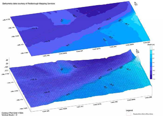
Figure 2: Surface and three dimensional contour plot of CSAFR (Source: McKinnon et al. 2004)
Appendix 6: Detailed description of the attributes of the Grassy Point Aquaculture Fisheries Reserve
The physico-chemical and biological features of the GPAFR have been assessed and described by the Primary Industries Research Victoria Queenscliff Centre as part of characterisation studies of the area (McKinnon et al. 2004). The following description is a synopsis of this information.
Location
The GPAFR is 252 ha (approximately 2.6 km by 1.1 km) in total area, which comprises the previous Grassy Point aquaculture harvesting area (187 ha) and extension along the northern boundary of 65 ha. The GPAFR is located 0.6 km offshore from the Bellarine Peninsula and has the following coordinates:
|
Datum GDA94 (Degrees and decimal minutes) | ||
|---|---|---|
| South | East | |
| North West | 38°05.999' | 144°40.692' |
| North East | 38°06.028' | 144°42.189' |
| South West | 38°06.621' | 144°40.667' |
| South East | 38°06.644' | 144°42.178' |
Bathymetry
Water depth at the GPAFR ranges from 7.5 to 14m. The seabed declines gradually in a northerly direction, with a shallow rise in the central third of the northern boundary. Depths are greatest in the north-east corner of the GPAFR.
Sediment characteristics
In the characterisation survey a total of 74 randomly allocated sampling sites were analysed. The sediment predominantly consists of very fine to medium gain sand (31–125 Pm) however the GPAFR substrate comprises a mixture of silt, sand and granules.
Redox measurements taken from the "existing zone" samples. The mean redox reading at the surface for the "existing zone" was 613.8 mV mean redox reading at 10mm was 596.8 mV and mean redox reading at 40mm was 512.0 mV. These readings suggests that the sediment samples at the GPAFR "existing zone" were marginally oxidative, displaying properties similar to normal ocean water.
Benthic Fauna
The GPAFR characterisation study investigated two subsections of the reserve, they were the existing area (existing) and an area that is an extension of the existing area (extended).
The benthic fauna of the GPAFR consists of many species, dominated by annelids of the families Lumbrineridae and Capitellidae and the mollusc Electroma georgiana.
A total of 94 taxa were identified in the existing zone, annelids from the family Lumbrineridae (mean density, 123 individuals per sample) dominate.
A total of 76 taxa were identified in the extended zone, annelids from the family Lumbrineridae (mean density, 227 individuals per sample) dominate.
Over all annelids and molluscs are the dominant taxa at the GPAFR. Other taxa represented at lower abundances are cnidarians, crustaceans, nemerteans and nematodes.
Epiflora and epifauna
Macroalgae species of the family Caulerpaceae were recorded throughout the GPAFR, frequently forming an algal mat. In areas where the mat was not as thick, burrow holes from marine invertebrates were evident.
Sparse seagrass beds of Halophila australis were recorded along the southern boundary of the GPAFR where the water depth was approximately 8 to 10 m.
Currents, wind and waves
The GPAFR is subject to daily tidal flushing that generates considerable mixing and exchange of water. Wind data collected during October 2002 were used with the Port Phillip Bay 400m grid to model currents . Modelled current directions vary from west to north-west on the flood tide, and from east to east-south-east on the ebb tide. Peak currents generally range from 0.08 to 0.20 m/s.
Wind data from the Point Wilson Automatic Weather Station approximately 5 km north-west of the CSAFR from the year 2000 were collated. The predominant wind directions in the Geelong Arm are from the west (19%) and the south (19%). The most common wind speed range was 21 – 30 km/h (34%) followed by the 11 – 20 km/h (31%), 31 - 40 km/h (16%), 10 km/h or less (10%), and greater than 40 km/h (8%).
Wave modelling using data from the year 2000 indicates that the GPAFR has significant wave heights greater than 0.5 metres 25% of the time. These waves are primarily produced by winds from the north (6%), the east (4%), the north-northeast (3%) and the west (3%). Under a modelled steady 40 knot wind the highest significant wave height at the GPAFR is likely to be 2.0 metres from the east.
Water quality
No notable freshwater discharges occur near the GPAFR, and the adjacent urban developments are sewered. Marine shellfish contamination events are commonly rainfall driven. There are some small stormwater drain along the adjacent shoreline.
The GPAFR is monitored under the VSQAP and has the highest water quality classification-approved. AQIS has accredited the GPAFR for harvest for shellfish for export. Food safety standard of product harvested within the GPAFR is assured through precautionary closures based on rainfall and phytoplankton triggers. The mean annual rainfall for the township of Clifton Springs (approximately 1 km south of the GPAFR) is 615 mm (Arnott 1991). VSQAP reports for the CSAFR are available from the Fisheries Victoria website www.depi.vic.gov.au/fishing-and-hunting.
During, February 1994 to March 1995 the mean chlorophyll a concentration in the GPAFR area was
1.81 ppb with a range of 0.79–4.19 ppb. An autumn increase in concentrations continuing into winter culminating in a rapid decline during late winter and early spring was recorded.
The major nuisance phytoplankton species detected at the GPAFR were Pseudo-nitzschia spp., Rhizosolenia chunii and Dinophysis acuminata (Water Ecoscience, 2002).

Figure 3: Surface and three dimensional contour plot of GPAFR extension and existing area (Source: McKinnon et al. 2004. Click image for a larger version.

Figure 4: Habitat plot of GPAFR extension (Source: McKinnon et al. 2004. Click image for a larger version.
Appendix 7: Detailed description of the attributes of the Kirk Point -Werribee Aquaculture Fisheries Reserve
The physico-chemical and biological features of the KWAFR have been assessed and described by the Primary Industries Research Victoria Queenscliff Centre as part of characterisation study of the area (McKinnon et al. 2004). The following description is a synopsis of this information.
Location
The KWAFR is a 200 ha (approximately 2.25 km by 0.85 km) in total area, which comprises the existing Werribee spat collection area (25 ha) and an extension of 175 ha. The KWAFR is located approximately 5 km offshore from the point at which the Little River enters Port Phillip Bay and has the following coordinates:
|
Datum GDA94 (Degrees and decimal minutes) | ||
|---|---|---|
| South | East | |
| North West | 38°02.990' | 144°37.979' |
| North East | 38°03.007' | 144°39.319' |
| South West | 38°03.541' | 144°37.967' |
| South East | 38°03.558' | 144°39.307' |
Bathymetry
Water depth at the KWAFR ranges from 6 to 10 m. Depths are generally shallower (6 to 7 m) along the northern boundary of the reserve. There is a gradual decrease down to approximately 10 m in a southerly direction.
Sediment characteristics
In the characterisation survey a total of 20 randomly allocated sampling sites were analysed. The sediment predominantly consists of very fine to medium-grained sand (63–250 Pm). The sediment was generally coarser in the shallower water, and finer in deeper waters. Burrow holes form macroinvertebrates were present in the softer sediment.
Redox measurements were taken from benthic grab samples. The mean redox reading at the surface was 21.6 mV, mean redox reading at 10mm was -61.2 mV and mean redox reading at 40mm was -106.7 mV. These redox readings suggest that the sediment samples at the KWAFR were marginally reductive, displaying properties similar to ground water or water logged soils.
Benthic Fauna
The benthic fauna of the KWAFR consists of many species, dominated by the mollusc Electroma georgiana (mean density, 74 individuals per sample) and the exotic mollusc Theora lubrica (mean density 23 individuals per sample), annelids of the family Amphsretidae (mean density, 21 individuals per sample) and crustaceans from the order Tanaidacea (mean density, 18 individuals per sample) and class Ostracoda (mean density, 17 individuals per sample). A total of 94 taxa were identified.
Epiflora and epifauna
The seagrass recorded in the area is mostly detrital. Within the northern boundary of the reserve there are aggregations of the ascidian Pyura stolonifera though aggregations are more extensive in shallower waters.
Currents, wind and waves
Wind data collected during October 2002 were used with the Port Phillip Bay 400m grid to model currents. Modelled current directions vary from west-south-west to north-west on the flood tide, and from north-east to east-south-east on the ebb tide. Peak currents generally range from 0.08 to 0.20 m/s.
Tidal currents are strongest at Point Henry Spit, up to 0.4 m/s in the Hopetoun Channel and up to 0.3 m/s in the North Channel. At Point Wilson Spit currents range from 0.15–0.2 m/s. In the Outer Harbour currents speeds are approximately 0.1 m/s west of Point Wilson Spit, increasing to 0.15 m/s in the east. At Point Lillias currents are <0.15 m/s and are south-west on flood tides and north east on ebb tides. Corio Bay has the weakest currents, which are commonly < 0.05 m/s (Manusell, 1995).
Maximum speeds of wind-driven currents are, in the order of 0.15–0.2 m/s. Where tidal currents are weak, such as Corio Bay and between Point Lillias and Point Wilson, wind-driven currents are expected to dominate, this is dependent on temporal environmental conditions.
Wind data from the Point Wilson Automatic Weather Station approximately 5 km north-west of the CSAFR from the year 2000 were collated. The predominant wind directions in the Geelong Arm are from the west (19%) and the south (19%). The most common wind speed range was 21 – 30 km/h (34%) followed by the 11 – 20 km/h (31%), 31 - 40 km/h (16%), 10 km/h or less (10%), and greater than 40 km/h (8%).
Wave modelling using data from the year 2000 indicates that the KWAFR has significant wave heights greater than 0.5 metres 28% of the time. These waves are primarily produced by winds from the east (5%), the west (3%), the south (3%) and the north (3%). Under a modelled steady 40 knot wind the highest significant wave height at the KWAFR is likely to be 2.1 metres from the east.
Water quality
The closest notable point source discharges are the WTP and Little River, located approximately 5.5 km north of the KWAFR.
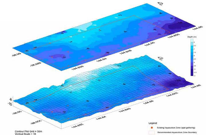
Figure 5: Surface and three dimensional contour plot of KWAFR (Source: McKinnon et al. 2004)
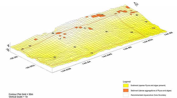
Figure 6: Habitat plot of KWAFR (Source: McKinnon et al. 2004)
Appendix 8: Detailed description of the attributes of the Bates Point Aquaculture Fisheries Reserve
The physico-chemical and biological features of the BPAFR have been assessed and described by the Primary Industries Research Victoria Queenscliff Centre as part of characterisation study of the area (McKinnon et al. 2004) The following description is a synopsis of this information.
Location
The BPAFR is a 25 ha (approximately 0.5 km by 0.5 km) in total area, and is a 'greenfield' area. Located in the Geelong Outer Harbour 0.7 km south-east of Point Lillias and has the following coordinates:
|
Datum GDA94 (Degrees and decimal minutes) | ||
|---|---|---|
| South | East | |
| North West | 38°5.451' | 144°27.303' |
| North East | 38°5.459' | 144°27.645' |
| South West | 38°5.722' | 144°27.294' |
| South East | 38°5.729' | 144°27.636' |
Bathymetry
Water depth at the BPAFR ranges from 7 to 9 m. The seabed slopes gently away in a westerly direction, with a shallow ridge within the western third of the BPAFR, running in a north-south direction.
Sediment characteristics
In the characterisation survey a total of 10 randomly allocated sampling sites were analysed. The sediment predominantly consists of very soft fine silt and very fine sand (17-31 µm). The closest emergent reef is located approximately 1 km east of the reserve.
Redox measurements were taken from benthic grab samples. Mean redox reading at the surface was -0.4 mV, mean redox reading at 10mm was - 160 mV and mean redox reading at 40mm was - 173.2mV. These redox readings suggest that the sediment samples at the BPAFR were mostly reductive, displaying properties similar to ground water or water logged soils.
Benthic Fauna
The benthic fauna of the BPAFR consists of a small number of species dominated by the exotic bivalve mollusc Theora lubrica (mean density, 51 individuals per sample) and nemerteans (mean density, 12 individuals per sample). Other taxa represented in lower abundance are molluscs, annelids, cnidarians, crustaceans and echinoderms. A total of 39 taxa were identified.
Epiflora and epifauna
Tufts of various species of macroalgae are sparsely distributed throughout the BPAFR. The only seagrass recorded at the BPAFR was detrital. Two areas to the west of the BPAFR, which are generally shallower, are colonised by the seagrass Halophila australis.
Currents, wind and waves
The BPAFR is subject to daily tidal flushing that generates considerable mixing and exchange of water. Wind data collected during October 2002 were used with the Port Phillip Bay 400m grid to model currents. Modelled current directions vary from south-south-west to west-north-west on the flood tide, and from north-north-east to east on the ebb tide. Peak currents generally range from 0.04 to 0.16 m/s.
Tidal currents are strongest at Point Henry Spit, up to 0.4 m/s in the Hopetoun Channel and up to 0.3 m/s in the North Channel. At Point Wilson Spit currents range from 0.15–0.2 m/s. In the Outer Harbour currents speeds are approximately 0.1 m/s west of Point Wilson Spit, increasing to 0.15 m/s in the east. At Point Lillias currents are <0.15 m/s and flow in a south-west direction on flood tides and north-east on ebb tides. Corio Bay has the weakest currents, which are commonly < 0.05 m/s (Manusell, 1995).
Maximum speeds of wind-driven currents are, in the order of 0.15–0.2 m/s. Where tidal currents are week, such as in Corio Bay and between Point Lillias and Point Wilson, wind-driven currents are expected to dominate, this is dependent on temporal environmental conditions. (Manusell, 1995).
Wind data from the Point Wilson Automatic Weather Station approximately 5 km north-west of the CSAFR from the year 2000 were collated. The predominant wind directions in the Geelong Arm are from the west (19%) and the south (19%). The most common wind speed range was 21 – 30 km/h (34%) followed by the 11 – 20 km/h (31%), 31 - 40 km/h (16%), 10 km/h or less (10%), and greater than 40 km/h (8%).
In the BPAFR area on an average annual basis winds from the west and south are predominant (occurring approximately 22% and 19% of the time), with winds from the north-west and north winds being the next most common (occurring for approximately 13% and 12% of the time). Wind speeds exceeding 5m/s and 10m/s occur for approximately 50% and 7.5% of the time, respectively (Manusell 1995).
In summer winds from the south (34% of the time) and south-east (15% of the time) are predominant. By comparison, in winter winds from the west, north-west and north are predominant occurring approximately 27%, 22% and 21% of the time respectively. Autumn and spring being transitional seasons commonly represent average annual conditions (Manusell 1995).
Wave modelling using data from the year 2000 indicates that the BPAFR has significant wave heights greater than 0.5 metres less than 6% of the time. These waves are primarily produced by winds from the east (1%), the east-south-east (1%) and the south-south-west (1%). Under a modelled steady 40knot wind the highest significant wave height at the BPAFR is likely to be 1.2 metres from the east.
The coast reduces the number and intensity of wave patterns from the north to the west (Manusell 1995).
Water quality
Chlorophyll a concentrations measured during February 1994 to March 1995 in the Werribee area, displayed a single early spring 'spike' in concentration that did not seem to effect the overall trend of relatively low constant concentration for the rest of the cycle. The mean annual chlorophyll a concentration was 2.71 ppb, with a range of 0.76–11.71 ppb. The peak chlorophyll a concentration consisted of 75% micro phytoplankton (>20µm).

Figure 7: Surface and three dimensional contour plot of BPAFR (Source: McKinnon et al. 2004). Click image for a larger version.
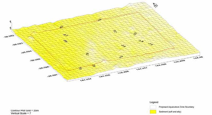
Figure 8: Habitat plot of BPAFR (Source: McKinnon et al. 2004)
Appendix 9: Victorian Shellfish Quality Assurance Program (VSQAP) phytoplankton monitoring triggers
| Phytoplankton Abundance Triggers for the VSQAP (cells/L) | |||||
|---|---|---|---|---|---|
| Alga/Algal Group | Toxin | Warning Issued | Tissue Testing | Harvest Suspension Pending Toxin Analysis | Harvest Resumption |
| Bacillariophyceae | |||||
|
Pseudo-nitzschia spp (<50% total phytoplankton) | ASP | 100000 | 300000 | 500000 |
<10 µg/g domoic acid for 3 successive samples over 14 days; phytoplankton abundance not rising |
|
Pseudo-nitzschia spp (>50% total phytoplankton) | ASP | 50000 | 100000 | 200000 | As above |
| Rhizosolenia cf chunii | Bitter Taste | 10000 | N/A |
20000 Level 2 Warning |
Harvesting suspended/resumed by growers depending on taste of mussels |
| Dinophyceae | |||||
| Alexandrium catenella | PSP | 100 |
Routine or 100 | *500 |
<80 µg/g PSP for 3 successive samples over 14 days: phytoplankton abundance not rising |
| Alexandrium minutum | PSP | 100 |
Routine or 100 | *500 | As above |
| Alexandrium tamarense | PSP | 100 |
Routine or 100 | *500 | As above |
| Alexandrium margalefi | Haemolytic? | 100 |
Routine or 100 | 500 | As above |
| Dinophysis acuminta | DSP | 1000 | 1000 | 2000 |
<16 µg/100 g PSP for 3 successive samples over 14 days; phytoplankton abundance not rising. |
| Dinophysis caudata | DSP | 1000 | 1000 | 2000 | As above |
| Dinosphysis fortii | DSP? | 1000 | 1000 | 2000 | As above |
| Gymnodinium catenatum | PSP | Presence | *100 | *500 |
<80 µg/100 g PSP for 3 successive samples over 14 days; phytoplankton abundance not rising |
|
Karenia cf brevis (=Gymnodinium cf breve) | NSP | Presence | *1000 | *5000 |
<20 MU/100 g for 3 successive samples over 14 days; phytoplankton abundance not rising |
|
Gymnodinium/Karenia spp (NOT catenatum, mikimotoi or brevis) | NSP? | 5000 | 5000 |
Not decided |
< regulatory limit for biotoxin for 3 successive samples over 14 days; phytoplankton abundance not rising |
| Prorocentrum lima | DSP? | 1000 | 1000 | 2000 |
<16 µg/100g DSP for 3 successive samples over 14 days; phytoplankton abundance not rising |
| Prorocentrum minimum | ? | 1000 | 1000 | 2000 | As above |
| Tissue Biotoxin Regulatory Limits for the VSQAP | ||||
|---|---|---|---|---|
| Toxin Class | Units | Regulatory Limit | Method | Limit of Detection |
| PSP | µg/100g | 80 | Bioassay | 26 |
| ASP (domoic acid) |
µg/100g (ppm) | 20 | HPLC | 0.5–1.0 |
| DSP | µg/100g | 16 | HPLC/MS | 0.3 |
| NSP | MUg/100g | 20 | Bioassay | 10 |
- µg - mircograms
- mm - millimetres
- ASP - Amnesic Shellfish Poisoning
- MS - Mass Spectrometry
- DSP - Diarrhectic Shellfish Poisoning
- MU - Mouse Units
- g - grams
- NSP - Neurotoxic Shellfish Poisoning
- HPLC - High Performance Liquid Chromatography
- ppm - parts per million
- L - litres
- PSP - Paralytic Shellfish Poisoning
Appendix 10: Standing Committee members and affiliation
Chair:
Dr David SmithPrimary Industries Research Victoria Queenscliff Centre
Committee members:
Mr Michael CallanVictorian Aquaculture CouncilMr Anthony Forster
Department of Primary Industries, Fisheries Victoria
Ms Madeline Glynn
Department of Sustainability and Environment
Mr John HotchinVRFishMr Don Hough
Department of Sustainability and Environment
Mr Ross McGowan
Seafood Industry Victoria
Mr Robert PearceVRFishMs Sheryl Raines
Victorian Aquaculture council
Mr Peter Rankin
Fisheries Co-Management Council
Mr Stephen RodisFisheries Co-Management Council
Executive Officers:
Dr Peter ApplefordFisheries Victoria
Mr Andrew Clarke
Fisheries Victoria
Mr Geoff GooleyPrimary Industries Research Victoria, Queenscliff Centre
Appendix 11: Potential ecosystem impacts of bivalve mollusc and offshore abalone culture
Bivalve Culture
| Ecosystem component | Potential threats | Potential consequences | |
|---|---|---|---|
| Source | Impact | ||
| Sediments | Metabolic wastes and pseudo faeces | Accumulation beneath the culture sites | Localised deterioration in ecological quality |
| Dead shells and other detritus | Accumulation beneath the culture sites | Alteration of physical structure of the sediment | |
| Water column | Filter feeding of stock | Uptake of primary and secondary production | Positive impact on coastal eutrophication |
| Depletion of essential nutrients | |||
| Modification of nutrient cycle | |||
| Reduction in dissolved oxygen levels | |||
| Servicing sites, processing | Input of wastes into water | Water quality impacts | |
| Biological | Seedstock | Collection of wild seed | Impacts on native population |
| Stock | Impacts on seagrass beds | Possible competition for feed | |
| Possible reduction in sunlight | |||
| Culture infrastructure | Obstruction of native fauna | Potential impacts on whales and dolphins | |
| Creation of novel habitats for exotics | Proliferation of exotics | ||
| Coastal Resources | Culture infrastructure | Large areas may interfere with the direction and velocity of tidal currents | Changes in sedimentation patterns |
Offshore Cage Abalone Culture
| Ecosystem component | Potential threats | Potential consequences | |
|---|---|---|---|
| Source | Impact | ||
| Sediments | Uneaten feed, pelleted or fresh seaweed. | Accumulation beneath culture sites | Localised deterioration in ecological quality |
| Cage Infrastructure | Scouring of adjacent sediments | Alteration of sediment quality | |
| Water column | Uneaten feed | Possible release of nutrients to water column | Deterioration in water quality |
| Biological | Stock | Escape of hatchery reared stock | Possible impacts on genetic diversity |
| Stock | Disease transfer to wild stock, genetic 'pollution' | Possible impacts on wild population | |
| Cage infrastructure | Creation of novel habitats for exotics | Proliferation of exotics | |
| Coastal Resources | Brood stock collection | Fishing pressure on stocks | Possible impacts on wild population |
Appendix 12: Summary of the recommended responsibilities of Crown lease and aquaculture licence holders
| Crown lease holder | Aquaculture licence holder | |
|---|---|---|
| Authorisation | Crown lease | Aquaculture licence |
| Environmental management | Fund and conduct a baseline survey for the lease site | Fund and conduct an ongoing monitoring program |
| Undertake appropriate remediation actions | ||
| Disease | Report diseases consistent with legislation | |
| Translocation | Comply with the relevant translocation guidelines | |
| Quality assurance programs | Licence holders producing bivalve shellfish for human consumption must participate in the VSQAP and comply with the Australian Shellfish Quality Assurance Program Operations Manual (ASQAAC 2002) | |
| Production reporting | Completion of production reports as required under the Fisheries Act | |
| Artificial feeds | Compliance with the SEPP | |
|
Survey and navigation marking |
Survey and navigation marking (including maintenance) of the Crown lease site. |
Maintain all commercial aquaculture equipment within the licence (Crown lease) site |
|
Fund and undertake surface infrastructure surveys for compliance purposes as required |
Fund and undertake surface infrastructure surveys for compliance purposes as required | |
|
Pay a levy for the inspection and maintenance of navigation marking infrastructure relating to the navigation marking of the FAFR | ||
|
Infrastructure requirements |
Compliant with infrastructure size, shape and colour, and infrastructure attachment recommendations | |
|
Request written approval prior to mooring barges, boats and other structures not compliant with the infrastructure recommendations within the FAFR for longer than 5 days | ||
| Stocking rates |
Comply with the prescribed input controls | |
|
Maintenance and removal of commercial aquaculture equipment |
Responsible for removal of improvements from the Crown lease site at the expiry/cancellation of the Crown lease |
Responsible for the maintenance of commercial aquaculture equipment as prescribed in the Plan |
|
Provision of a bond or bank guarantee for the removal of aquaculture equipment |
In accordance with the Fisheries Act remove aquaculture equipment at expiry/cancellation of licence | |
|
Waste management/ processing |
Manage waste and processing in accordance with legislation, the relevant food safety/quality assurance programs and industry code of practice | |
| Noise and lighting |
Comply with relevant legislation and industry code of practice | |
|
Rate of development |
Comply with prescribed rate of development for the Crown lease site |
Comply with prescribed rate of development for the licence site development |
|
Public liability insurance |
Hold a public liability trespass insurance policy consistent with the requirements of the Plan | |
| Bonds |
Provide a bond or bank guarantee to the prescribed value by an agreed mechanism | |
| Exotic organisms |
Report the presence of exotic organisms consistent with the requirements of the Plan |
Appendix 13: Transitional arrangements for existing licence holders
The time limits allowed for existing licence holders to become compliant with the Plan are based on three
broad categories of risk: human health and safety, environment, and social.
The time limits allowed for existing licence holders to become compliant with the Plan are based on three
broad categories of risk: human health and safety, environment, and social.
- In regard to management arrangements relating to human health and safety, compliance will be required within three months of the declaration of the Plan.
- In regard to management arrangements relating to environmental risk, compliance will be required within 12 months of the declaration of the Plan.
- In regard to management arrangements relating to social risk, compliance will be required within five years of the declaration of the Plan.
| Transitional arrangement | Risk category | Time permitted for transition |
|---|---|---|
| Navigation marking of licence sites | Human health and safety | Within three months of the declaration of the Plan. |
| Environmental management - ongoing monitoring | Environmental | Within 12 months of the declaration of the Plan. |
| Infrastructure requirements | Environmental | All commercial aquaculture equipment deployed prior to the declaration of the Plan must be compliant with the requirements of the Plan in relation to identification and secure attachment of buoys within 12 months of the declaration of the Plan; and |
| Infrastructure requirements | Social | All commercial aquaculture equipment deployed prior to the declaration of the Plan must be compliant with the visual amenity requirements of the Plan within five years of the declaration of the Plan; and |
| Public liability insurance | Human health and safety | All existing licence holders must provide evidence of a current insurance policy to the Secretary, DPI within three months of the declaration of the Plan. |
Appendix 14: Timetable for the implementation of key actions recommended in the Geelong Arm Aquaculture Fisheries Reserves Management Plan
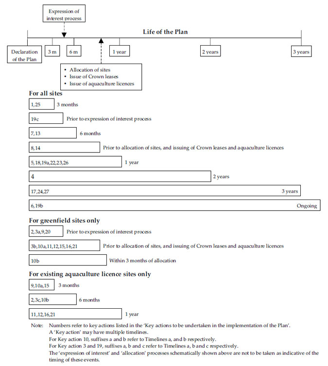
Appendix 15: List of recommended fees, costs and levies relating to the implementation of the Geelong Arm Aquaculture Fisheries Reserves Management Plan
Where possible the value of fees, costs and levies is provided below. The value of fees, costs and levies
change and consequently the listed amounts are correct at the time of writing only. Costs are reviewed each
year and changes are published in the Victoria Government Gazette.
New recommended fees, costs and levies relating to the implementation of the Geelong Arm Aquaculture
Fisheries Reserves Management Plan.
- A levy to recover costs associated with inspection and maintenance of navigation marking of the Reserves from aquaculture licence holders for each reserve.
- Crown lease holder's and aquaculture licence holder's costs relating to environmental baseline surveys and ongoing monitoring respectively.
- Crown lease holder's costs relating to the provision of a bond or bank guarantee for cost recovery for the removal of abandoned commercial aquaculture equipment.
- Crown lease administration cost.
- Public liability insurance requirements for lease holders.
- Cost of changing infrastructure.
Existing fees, costs and levies relating to aquaculture in the Geelong Arm Aquaculture Fisheries Reserves.
Fees and levies applicable for the year commencing 1 November 2004 to aquaculture licences in the Geelong Arm Aquaculture Fisheries Reserve are illustrated below. Fees and levies are subject to change in accordance with the implementation of cost recovery following a Regulatory Impact Statement or CPI increase.
| Category of Licence | Annual Management FMS Levy1 | Annual Compliance FMS Levy1 | Annual Research FMS Levy1 | Annual Research FRDC Levy1 | Annual Peak Body Levy2 |
|---|---|---|---|---|---|
| Aquaculture (Crown Land - Bivalve Shellfish) Licence | $1091 | $804 | $0 | $154 | $181 |
| Aquaculture (Crown Land - Other) Licence | $531 | $571 | $0 | $154 | $181 |
| Aquaculture (Crown Land - Abalone) Licence | $509 | $400 | $138 | $154 | $181 |
1Levied annually per licence.
2Payable only once per year per licence holder.
The amount of the applicable VSQAP levy for an Aquaculture (Crown Land – Bivalve Shellfish) Licence is calculated in accordance with regulation 617A of the Fisheries Regulations 1998 and varies according to the formula as provided in that regulation. For the 2004/05 licence period the VSQAP levy for the GPAFR was $866.85 per 3 ha and for CSAFR was $589.17 per 3 ha.
Lease/licence holders costs relating to the provision of a survey of a lease/licence site.
Lease/licence holder costs relating to the marking of a lease/licence site.
Footnotes
1 For the purpose of this fisheries reserves management plan the Geelong Arm is defined as 'the waters of Port Phillip Bay west of a line from Indented Head to the point at which the Werribee River enters Port Philip Bay, including but not limited to the Geelong Outer Harbour'.
2 A licence site is the area specified on an aquaculture licence issued under section 43 of the Fisheries Act within which aquaculture activity is authorised.
3 Cage culture includes the culture of abalone contained in cages suspended in mid-water and/or movable cages located on the seafloor.
4 Multiple species from the phyla Chlorophyta, Phaeophyta and Rhodaphyta.
5 Abalone ranching is the non-contained culture of abalone on structures.
6 Note that NRE (Department of Natural Resources and Environment) is now the Department of Primary Industries and the Department of Sustainability and Environment.
7 Compliance points are those specific locations within the Crown lease/aquaculture licence site at which survey data and or samples will be measured/collected, typically along a specific transect. Reference sites are effectively compliance points which are located outside the Crown lease/aquaculture licence site at a predetermined location and designed to be used as 'control' to clarify the extent of environmental impacts attributable to aquaculture activity within the Crown lease/aquaculture licence site.
8 "Artificial feeds" includes pelleted formulated feeds, whole/trash fish and by-products used for aquaculture purposes.
9 Buffer zones when required will be designed to ensure impacts attributable to aquaculture activity are contained within the reserve.
10 "Longline backbone" is the length of longline backbone (headline) that is available for the attachment of production substrate. No differentiation will be made between the length of single and double backbone longline.