Corangamite Fishery Management Plan Nov 2008
Fisheries Victoria Management Report Series No. 59
November 2008
ISSN: 1448-1693
ISBN: 978-1-74199-909-9 (print)
ISBN: 978-1-74199-910-5 (PDF)
Preferred way to cite this publication: Department of Economic Development, Jobs, Transport, and Resources (former) Department of Primary Industries 2008, Corangamite Fishery Management Plan, Fisheries Victoria Management Report Series No. 59.
Executive summary
The purpose of the Corangamite Fishery Management Plan (CFMP) is to specify the objectives, strategies and actions for managing fishing activities within the Corangamite fishery over the next five years.
The purpose of the CFMP is to manage recreational fishing in the Corangamite fishery in accordance with the principles of ecologically sustainable development (ESD). This includes identifying habitats and aquatic environments on which fisheries resources depend, and enhancing social and economic benefits to all Victorians.
The CFMP prescribes fishery management arrangements in accordance with a nationally agreed framework for applying the principles of ESD to fisheries (Fletcher et al. 2002).
The Corangamite fishery is defined as all inland waterways (i.e. lakes, rivers and estuaries) in the Otway, Moorabool, Barwon and Corangamite basins and is aligned with the geographical boundaries of the Corangamite Catchment Management Authority (CCMA) region. It does not include marine waters.
The Corangamite fishery does not include commercial bait fishing or aquaculture as these activities are managed through commercial and aquaculture licensing processes respectively nor does it include the recreational or commercial eel fisheries which are managed by the Victorian Eel Fishery Management Plan (DNRE 2002a).
The Corangamite fishery includes several popular recreational fisheries of state-wide significance. The Gellibrand River and tributaries support a premier river blackfish fishery. Popular salmonid fisheries include the volcanic lakes, Bullen Merri and Purrumbete, and the sea-run trout rivers of the Otway coast. Popular estuaries include the Barwon, Barham and Curdies Rivers and Hovell Creek where fishers target black bream, snapper, King George whiting, estuary perch and seasonal species such as Australian salmon and mulloway.
The CFMP describes the main rivers, estuaries and lakes, and key recreational fishing species; current management arrangements for recreational fishing activities; goals, objectives, performance indicators, targets and actions for management of recreational fishing activities; and processes for managing other relevant issues to provide for the sustainable use of natural resources and recognition of the social and economic values of the fishery by all relevant agencies.
Actions to be implemented in the next five years include:
- Establishing monitoring programs for the iconic river blackfish fishery and other key species.
- Preparing a Stream Classification Model to identify native, mixed and salmonid fisheries.
- Ongoing stocking of fish in support of recreational fishing in suitable waters.
- Monitoring fishing values and preferences and identifying and encouraging responsible fishing behaviour.
- Providing advice to habitat resource managers with the aim of achieving better outcomes for key fisheries resources.
- Identifying opportunities to improve access to fisheries resources through the Victorian Recreational Fishing Peak Body (VRFish).
Where information from these strategies and actions identifies a need to alter management arrangements to ensure sustainable use or to meet changing demands for recreational fishing opportunities, changes will be considered in consultation with stakeholders and management agencies.
A Corangamite Fishery Reference Group will be established to work with the department to deliver the desired management outcomes for the Corangamite fishery. It is proposed that the group include representatives nominated by the department, VRFish and the CCMA.
Introduction
The Fisheries division (Fisheries Victoria) of the department works with its stakeholders to facilitate the sustainable development of fisheries resources. A key task in sustainable management is preparing and implementing fishery management plans.
Fishery management plans specify the objectives, strategies, actions and performance measures for managing fishing activities in accordance with the principles of ecologically sustainable development (ESD).
Recreational fishing is the primary fishing activity in Victoria's rivers, tributaries, estuaries, lakes and impoundments. Other fishing activities in inland areas of Victoria include commercial bait and eel fishing and aquaculture. Inland fishery management plans focus on managing recreational fishing activities to enhance environmental, social and economic outcomes and recognise the importance of fisheries resources to Indigenous communities.
Inland fishery management plans are prepared with a strong focus on establishing partnerships with relevant catchment and water management agencies. Effectively managing inland fisheries requires the implementation of appropriate fisheries management tools (for example, bag and size limits) and recognition that other human activities in the catchment may be equally or more important to sustaining fish stocks.
The Corangamite Catchment Management Authority (CCMA) is one of ten Catchment Management Authorities that have responsibility for managing catchments and waterways in Victoria. Catchment Management Authorities develop and implement Regional Catchment Strategies and sub strategies such as the Regional River Health Strategies. To effectively align catchment and fishery management strategies and the efficient delivery of management actions, the Corangamite Fishery Management Plan (CFMP) is aligned with the boundaries of the CCMA.
The Corangamite fishery includes all lakes, impoundments, rivers and estuaries in the Corangamite, Barwon, Moorabool and Otway basins. The CFMP provides management direction for fishing activities across the inland area administered by the CCMA and included in the Corangamite fishery for the next five years.
The CFMP recognises that management of fishery resources must often occur at scales larger than Catchment Management Authority boundaries. Fisheries Victoria has identified key asset groups where similar species and ecological characteristics are found and manages these groups on a statewide basis.
A summary of the key acronyms and websites used in this management plan is included in Appendix 1.
Description of the region
The Corangamite region comprises approximately 13,340 square kilometres of southwest Victoria encompassing the coastline adjacent to the Great Ocean Road; the historic gold mining region around Ballarat; and the Victorian Basalt Plain which slopes west to east through the centre of the area flanked by the Otway Range to the south and the Central Highlands to the north. Volcanic hills emerge from the Basalt Plain and provide a backdrop to large lakes that are set in an otherwise flat landscape (Figure 1).
The Corangamite region includes all or part of the cities of Ballarat and Greater Geelong, the Borough of Queenscliff and the shires of Moorabool, Surf Coast, Corangamite, Golden Plains, Colac Otway and Moyne. It includes four major river basins: the Moorabool, Barwon, Lake Corangamite and Otway Coast.
The Moorabool Basin includes the Moorabool River and two main tributaries, the East and West Moorabool rivers, which are important recreational fisheries in the Basin. Key recreational fishing species in the Moorabool Basin include brown and rainbow trout, redfin and river blackfish.
Both the East and West Moorabool rivers rise in the well-watered, south facing slopes of the central highlands between Ballarat and Ballan and flow southwards before combining at Morrisons. The Moorabool River continues south and joins the Barwon River near Geelong.
The Moorabool Basin includes the Hovell Creek catchment, which is a small system arising in the southern foothills of the Brisbane Ranges and the You Yangs and flowing southeast into Corio Bay (CCMA 2004). Key recreational fishing species in the Hovell Creek catchment are estuarine species including black bream.
The Lake Corangamite Basin has no natural outlet but drainage works have established two artificial drainage channels that connect it to the Barwon Basin. This basin is dominated by a series of saline lakes into which all its watercourses run. This basin contains Lake Bullen Merri which is a key recreational fishery and is stocked by the department with salmonid species. The Woady Yaloak River is popular for fishers seeking trout.
The main waterways in the Otway Coast Basin include the Curdies, Gellibrand and Aire rivers. The Curdies River drains the area west of the Otway Ranges, whilst the Gellibrand and Aire rivers, along with a number of other smaller coastal streams, drain the central Otway Ranges. To the east, there are numerous smaller coastal streams including the Erskine River, Thompson Creek and Spring Creek. Recreational fishing is popular throughout the Basin and key fisheries include the Curdies, Gellibrand, Aire and Ford rivers and Lake Purrumbete. DPI stocks Lake Purrumbete with salmonids and fishers target salmonids, river blackfish and black bream in many of the rivers and estuaries in the region.
The Barwon Basin includes the Barwon and Leigh (Yarrowee) rivers. The Barwon River flows into the Lake Connewarre estuary system which is a key recreational fishery in the region. Other significant fisheries in the basin include Lakes Modewarre, Murdeduke, Wurdiboluc and Wendouree. When water levels are suitable, DPI stocks these waters with salmonid species and the lakes support recreational species such as eels and redfin.
The Great Otway National Park
Within the Corangamite region, the newly established Great Otway National Park incorporates the former Otway National Park and Angahook-Lorne, Carlisle and Melba Gully State Parks, as well as areas of State forest and other Crown land. The Park covers 103,000 hectares and includes representative examples of tall wet mountain forests, rainforests, drier forests of the inland slopes, heath-lands and coastal environments. Fishing is permitted within the Park and key fisheries include the upper Gellibrand River where fishers target river blackfish and trout, and the black bream and estuary perch fisheries near Princetown.
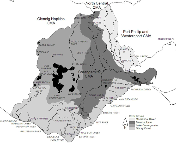
Figure 1: Map of the Corangamite fishery. CMA = Catchment Management Authority
Wildlife and lake reserves
Parks Victoria is the responsible management agency for the Wildlife and Lake Reserves and Ramsar sites in the Corangamite region. Lake Reserves in the region include Modewarre and Murdeduke lakes. Wildlife Reserves include Purrumbete and Beeac lakes. In accordance with the Wildlife Act 1975, Wildlife Reserves are areas that have been reserved for the "propagation or management of wildlife or the preservation of wildlife habitat."
Within many parks and reserves, fishing is permitted in accordance with prescribed fishing regulations. Information on fishing in specific parks and reserves is available on the Parks Victoria website at www.parkweb.vic.gov.au.
Ramsar sites
The extensive system of lakes and wetlands are defining features of the Corangamite region and are of national and international significance (CCMA 2003). The region includes the majority of the Western District Lakes Ramsar Site and parts of the Port Phillip Bay (Western Shoreline) and Bellarine Peninsula Ramsar Site. The Ramsar Convention also recognises waterways that feed wetlands of international importance.
Key recreational fisheries with Ramsar significance include lakes Murdeduke, Connewarre and Reedy, sections of Hovell Creek and the Barwon and Woady Yaloak rivers.
Heritage Rivers
A 35 kilometre reach of the Aire River, from Hopetoun Falls Scenic Reserve to the ocean, is the only Heritage River within the Corangamite region. The entire length of the Aire River is recognised as a representative river in the region. The introduction of non-native fish species into Heritage Rivers is not permitted.
Current fishing activity
Recreational fishing
The most recent study of recreational fishers in Australia, the National Recreational and Indigenous Fishing Survey (Henry and Lyle 2003), found there were approximately 550,000 active fishers in Victoria who divided their fishing effort about equally between fresh and marine species. Approximately 58 per cent of fishers were based in the Melbourne area.
The survey found that Victorians spent approximately $400 million per annum, or $721 per fisher, on goods and services associated with recreational fishing activities, the highest per capita expenditure in Australia.
Commercial fishing
Commercial fishing activity within the Corangamite region is limited to eels, bait and noxious aquatic species.
The eel fishery is managed through the Victorian Eel Fishery Management Plan (DNRE 2002a). Commercial harvesting of eels in the Corangamite region occurs in the following specified waters:
- Lake Connewarre State Game Reserve including the Lower Barwon River and Hospital Swamp, but excluding Lake Connewarre
- Aire River downstream of the Great Ocean Road
- Lake Corangamite; Tooliorook (Ettrick) and Deep lakes
- Curdies River downstream of The Narrows
- Curdies Inlet
- Gellibrand River downstream of the Great Ocean Road at Lower Gellibrand.
With a few specified exceptions, Eel Fishery Access Licence holders may fish in all Crown lakes, dams, swamps, marshes and morasses south of the Great Dividing Range,.
Bait licences allow for the harvest and sale of bait species, including yabbies, using prescribed commercial fishing equipment. Bait licences are issued in line with ecologically sustainable develop principles. One bait licence holder currently operates in the Corangamite region.
Two commercial operators are authorised under noxious aquatic species permits to take carp but they do not regularly operate in the region.
Aquaculture
Under the thirteen classes of aquaculture licences that authorise inland aquaculture in Victoria, licence holders may grow trout, yabbies, eels, abalone, warm water finfish, ornamental fish and other species for commercial purposes. Aquaculture in the Corangamite region is currently authorised under 16 aquaculture licences.
Key asset groups
A basis for strategic state-wide fisheries management is the grouping of areas with similar environmental, geo-morphological and fishery species characteristics into key asset groups. These are used to assist in identifying and describing issues.
The Corangamite fishery contains the following fisheries key asset groups:
- Rivers
- Lakes
- Estuaries.
Key asset groups will not be used as the basis for introducing different fishing regulations at smaller spatial scales within the Corangamite fishery.
The following sections provide information on the recreational fishing species generally found in each key asset group. Information has been obtained from the Guide to Inland Angling Waters of Victoria, from Fisheries Victoria regional staff and through public consultation undertaken during the preparation of this management plan.
Rivers
Rivers in the Corangamite fishery typically contain a range of native and introduced species.
Public consultation suggested that the most popular fishery species included brown and rainbow trout, river blackfish and redfin. Trout and river blackfish populations in this key asset group are self-sustaining and no stocking occurs. Other recreational fishery species include tupong and short-finned eels (Appendix 2).
This key asset group includes forested coastal streams in the Otway Ranges, wide slow-flowing rivers running through grazing and agricultural land and smaller inland creeks.
Coastal rivers such as the Barwon, Curdies, Gellibrand, Aire, Barham and Ford are very popular recreational fishing locations. Also important to recreational fishers in the Corangamite fishery are the Carlisle, Cumberland, Erskine, Moorabool and Woady Yaloak rivers and Skenes, Spring, Smythes, Thompsons, Wild Dog and Little Aire creeks.
For the purposes of the Fisheries Regulations, the Aire, Ford and the Gellibrand rivers downstream of the Great Ocean Road are Sea-run Trout Rivers. Regulations for Sea-run Trout Rivers are found in the Victorian Recreational Fishing Guide.
Lakes
Lakes are all static water bodies including impoundments that support or have supported fish species targeted by recreational fishers across the Corangamite fishery. Many impoundments have been stocked and are popular areas for recreational fishing.
Bullen Merri, Purrumbete, Wurdiboluc, Murdeduke and Modewarre lakes are the most popular Lakes for recreational fishing in the Corangamite fishery. Other popular lakes and the key recreational fishing species within this key asset group are described in Appendix 2.
The key recreational fishing species in the lakes and impoundments are salmonids including brown and rainbow trout and Chinook salmon. Some lakes such as Bullen Merri also contain Australian bass.
Some lakes of the Corangamite fishery contain wetland habitats that are environmentally significant and are listed in the Directory of Important Wetlands in Australia (Environment Australia 2001).
The directory aims to raise public awareness of wetland sites and provides a basis for land managers and the community to undertake actions that will contribute to the conservation of wetlands. The directory lists approximately 150 wetlands of which eight occur in the Corangamite fishery: Lake Connewarre State Wildlife Reserve, Lower Aire River Wetlands, Lake Colongulac, Lake Corangamite, Lake Gnarpurt, Lake Murdeduke, Lake Wendouree and the Aire River.
Family Fishing Lakes Program
The DPI Family Fishing Lakes Program provides recreational fishing opportunities for fishers of all ages and abilities at locations within or near population centres throughout the State. Under the program, 150 to 200 gram ready-to-catch trout are stocked into family fishing lakes at times that maximise fishing opportunities (e.g. second or third term school holidays, fishing weeks or junior fishing clinic events).
In most instances, rainbow trout are stocked because they are normally larger than the available brown trout and are reputedly easier for inexperienced fishers to catch.
There are six Family Fishing Lakes in the Corangamite region which are detailed in the Victorian Recreational Fishing Guide that is also available at most fishing tackle shops.
Estuaries
Estuaries within the Corangamite fishery include the lower reaches of the Aire, Barham, Barwon (including Lake Connewarre), Curdies, Gellibrand and Hovell (Limeburners Bay) creeks and rivers. Smaller estuaries such as the Erskine at Lorne, the Painkalac at Aireys Inlet and the Anglesea, Thompson and Skenes are also important to recreational fishers.
Estuaries provide accessible and important recreational fishing opportunities. Coastal townships in the Corangamite fishery were established along estuaries with most townships linked by the Great Ocean Road.
The estuaries of the Corangamite fishery support a diverse range of fish species. The key recreational fishing species include black bream, snapper, King George whiting, sweep, Australian salmon, mulloway and estuary perch. Other species targeted by fishers are detailed in Appendix 2.
Many estuaries along the Victorian coast are intermittently open and close naturally when currents deposit sand at the entrance. Closure often coincides with periods of low freshwater flow into the estuary. When the entrance closes and the length of time it remains closed influences the physicochemical conditions of the water (e.g. oxygen, salinity and temperature) and the fish species found within it.
When an estuary is closed, rising up-stream waters flood wetlands and littoral vegetation and increase available fish habitat. The sand bars of some estuaries are artificially breached to prevent flooding of adjacent land or protect infrastructure. Mass fish mortalities have occurred in some estuaries when the entrance breaches and only the surface layer flows out leaving the anoxic bottom waters behind or when anoxic water from wetlands flows into the estuary resulting in fish death events.
Key native recreational fishing species
Native fish species provide important recreational fishing opportunities and provide a major social and economic contribution to regional communities. Native recreational fishing species are important components of the ecosystem and recreational harvest must be managed in accordance with the broader ecological, economic and social values of the region.
Key native recreational fishing species in the Corangamite fishery include inland and estuarine species. River blackfish are very popular in many rivers and black bream and estuary perch are popular estuarine species. Mulloway, King George whiting, yellow-eye mullet and Australian salmon utilise estuaries and are popular fishery species at different times in their life history or when conditions are suitable.
River blackfish (Gadopsis marmoratus)
River blackfish are widely distributed throughout Victoria (DPI 2003a) and are found in many rivers and tributaries across the Corangamite fishery. The Gellibrand River and tributaries contain a healthy river blackfish population, which is valued by recreational fishers. The Moorabool, Aire, Carlisle and Ford rivers are also significant fisheries for river blackfish. This species is distinct from the two-spined river blackfish (Gadopsis bispinosis) that is typically found in north-eastern Victoria.
River blackfish prefer cool, clear streams with gravel, cobble or boulder substrate and abundant cover. Adult and older juvenile river blackfish prefer an abundance of snags and cover (Jackson and Davies 1983) in well oxygenated waters (Fletcher 1979). Introduction of artificial habitat including boulders and woody debris to otherwise sparse bottom has increased abundance and confirmed its preference for in-stream habitat and shelter where high water velocities are present (Koehn 1987).
River blackfish are carnivores and feed on aquatic insects, crustaceans, small fish and molluscs (Koehn and O'Connor 1990).
Spawning usually occurs in spring and early summer when water temperatures are approximately 16°C (Koehn and O'Connor 1990). Eggs are strongly adhesive, may be deposited in hollow logs and rock cavities and are thought to be guarded by the males (Jackson 1975). Eggs hatch approximately fourteen days after fertilisation and young river blackfish actively swim and seek food approximately five weeks after hatching (Koehn and O'Connor 1990). Small juveniles spend much of their time near the bottom and are heavily preyed upon by nymphs, dragonfly larvae and crustaceans (Koehn and O'Connor 1990). Adults can be aggressive towards other species and are nocturnal (Koehn and Morison 1990). River blackfish have a limited home range between 25 to 30 metres (Koehn 1986).
Black bream (Acanthopagrus butcheri)
Black bream are an endemic species that inhabits estuarine waters of southern Australia (Kailola et al. 1993). Black bream may be found inhabiting rocky, river beds around structures and snags and may be caught over seagrass, mud and sand substrate (Cashmore et al. 2000). Black bream are rarely found at sea although adult black bream are known to undertake migrations between estuaries (Hall 1984) and may enter the sea following large rainfall events.
Adult black bream feed opportunistically on a variety of organisms including bivalve and gastropod molluscs, prawns and crabs, marine worms and small fish (Cashmore et al. 2000).
Spawning usually occurs from August to January but may begin later in more westerly estuaries (Cadwallader and Backhouse 1983). Female black bream spawn after reaching approximately 24 centimetres total length and release 300,000 to 3 million eggs per spawning event. Males become sexually mature at approximately 22 centimetres total length (Kailola et al. 1993). Larval survival is dependent on suitable salinity and water temperature and availability of food and habitat (Cashmore et al. 2000).
Larvae and small juvenile black bream are found primarily amongst seagrass beds which provide invertebrate prey and shelter (Cashmore et al. 2000).
Estuary perch (Macquaria colonorum)
Estuary perch occur in tidal estuaries, rivers and sometimes in freshwater lakes (Williams 1970; Allen 1989). Little is known of the early life history of the species, but nursery areas for small juveniles are thought to be in the upper reaches of estuaries. Larger juveniles and adult estuary perch are associated with submerged tree branches and seagrass beds where they shelter and feed as ambush predators on smaller fish and crustaceans.
Estuary perch are believed to breed in the salt wedge at the mouth of estuaries. Salt wedges occur in estuaries including the Barwon, Aire, Gellibrand, Barham, Anglesea and Painkalac. Salt wedges provide opportunities for successful spawning of estuary perch, particularly in larger estuaries and it is likely that populations in the Barwon constitute a source of recruitment for smaller estuaries such as the Barham (McGucken 2006).
In response to rising temperatures, adult estuary perch migrate into areas of high salinity to spawn. Spawning occurs during November and December in Victoria when water temperatures reach 14 to 16°C (Allen 1989). Estuary perch spawn in brackish waters in areas with submerged aquatic plant beds adjacent to deep banks.
Eggs and larvae remain in the water column for two to three days prior to hatching. Juvenile perch remain in areas of high salinity before moving into lower salinity areas as they grow older (Koehn and O'Connor 1990) and may congregate in schools until they reach seven centimetres in length. Larger fish do not appear to display schooling behaviour.
Mulloway (Argyrosomus japonicus)
Mulloway inhabit coastal waters from Bundaberg in Queensland, around southern Australia to Carnarvon in Western Australia. Mulloway occur in the lower reaches of rivers, estuaries, bays, inlets, waters off beaches and in open waters to a depth of 150 metres. Mulloway are common in western Victorian waters, but are much less abundant in waters east of Melbourne (Kailola et al. 1993).
Mulloway reach sexual maturity at six years and approximately 75 centimetres total length and live up to 30 years. They spawn in the surf zones close to ocean beaches from late spring to summer and larvae are thought to remain in open coastal waters for several months. Juveniles are thought to have wide salinity tolerances and enter estuaries and rivers when they are five to ten centimetres total length (Kailola et al. 1993).
One to two year old juvenile mulloway are most common in New South Wales estuaries from February to September, while young adults can be found bays and estuaries from September to October (Kailola et al. 1993).
Mulloway feed on a variety of organisms including other mulloway, yellow-eye mullet, garfish, crabs, prawns and worms (Kailola et al. 1993).
King George whiting (Sillaginodes punctata)
King George whiting inhabit marine bays, marine sections of estuaries and shallow coastal waters of southern Australia from central New South Wales to the central west coast of Western Australia. The southern limit of distribution is the north coast of Tasmania (Gomon et al. 1994).
King George whiting are found in most shallow, sheltered coastal waters of Victoria but are most abundant in large marine embayments such as Corner Inlet and Port Phillip Bay.
Other species of whiting found in Victorian waters include the eastern school whiting (Sillago flindersi) and the east coast sand whiting (S. ciliata).
Adult King George whiting in breeding condition, or small whiting less than about 100 days old, are virtually absent from bay and inlet waters of central Victoria. It has been hypothesised that recruitment to these areas is derived from spawning in coastal waters to the west of Port Phillip Bay and that recruitment from South Australian waters may be possible (Jenkins and May 1994; Jenkins et al. 2000).
Available evidence from studies of gonad maturation and ageing of post-larvae indicate that King George whiting spawn during autumn or early winter. To date the only known spawning area for King George whiting is open coastal waters of South Australia (Jenkins et al. 2000).
The species has a long planktonic larval life, with post-larvae settling into very shallow, sheltered marine habitats in Victorian bays and inlets at 100 to 170 days of age (Jenkins and May, 1994). Juveniles remain in sheltered marine waters, usually in association with seagrass habitats, for two to three years, after which they begin to move to deeper, more open waters (Kailola et al. 1993).
Based on scale ageing in South Australia, King George whiting have a reported maximum life span of 15 years. The maximum length and weight are reported to be 72 centimetres and 4.8 kilograms, respectively (McKay 1992). Few fish caught in Victorian bays and inlets exceed 40 centimetres total length or one kilogram.
Yellow-eye mullet (Aldrichetta forsteri)
Yellow-eye mullet inhabit bays, estuaries and open coastal waters of Victoria's coastline where they school and form aggregations over sand and mud substrates (Kailola et al. 1993). Yellow-eye mullet have broad salinity and temperature tolerances and have been reported in brackish and open ocean waters.
Yellow-eye mullet are commonly found in the Barwon, Gellibrand and Curdies estuaries and are also an important fishery species in many smaller estuaries such as the Painkalac and Thompson creeks and the Anglesea River. It is likely that adult yellow-eye mullet feed just outside of the river mouth and move in and out of the river. All of the other western inlets have river mouths that close over periodically, which restricts the entry and exit of shoals of mullet.
Yellow-eye mullet can reach 40 centimetres total length (Hall 1984) and mature at about two to three years of age (Harris 1968). Mature fish form large aggregations in coastal waters and marine embayments prior to spawning.
In Victorian waters, spawning may occur from late spring until autumn (Ramm 1986). The spawning locations and details of the larval life of yellow-eye mullet in Victorian waters are not well understood, but spawning is suggested to occur predominantly in coastal waters outside bays and inlets (Chubb et al. 1981; Jenkins et al. 1996).
When they attain a size of 30 to 40 millimetres total length, juvenile yellow-eye mullet move into Victorian bays and estuaries from late summer through to early spring (Ramm 1986; Jenkins et al. 1993; Jenkins et al. 1996; Robertson 1978). Juveniles are abundant in shallow water over seagrass and unvegetated sand habitats but are less common over shallow reefs (Jenkins et al. 1993; Jenkins et al. 1996).
Young juveniles feed mainly on zooplankton; older juveniles and adults feed on detritus, plankton, filamentous algae, marine worms and other small invertebrates. Algae may dominate the diet of larger fish (Edgar et al. 1993).
Australian salmon (Arripis truttaceus)
Australian salmon is a migratory, schooling marine species found in coastal waters, bays and estuaries of southern Australia and up the east and west coasts to approximately 30° South (Kailola et al. 1993).
Australian salmon can tolerate temperature and salinity extremes, such as the brackish and turbid waters of estuaries, or the hyper-saline waters of the South Australian gulfs.
Morphological and genetic studies (MacDonald 1983) have confirmed two species of salmon in southern Australian waters: western salmon (Arripis truttaceus) in waters of Western Australia, South Australia, Victoria and Tasmania, and eastern salmon (A. trutta) in waters of southern New South Wales, Victoria and Tasmania.
Western salmon predominate west of Port Phillip Bay and spawn in coastal waters off the south coast of Western Australia between March and May (Cappo 1987).
In Victoria, western and eastern salmon up to two years of age are found mainly in bays and estuaries, often in association with seagrass beds.
Western salmon juveniles feed on zooplankton and bottom-dwelling fauna such as fishes and crustaceans, particularly in seagrass beds (Robertson 1978).
Juvenile salmon larger than 30 centimetres total length move out of bays and estuaries into more exposed coastal waters such as around rocky headlands and along surf beaches. Maturing western salmon form schools and move west along the southern coast to their respective spawning grounds.
Other species
Other native species, including flathead, garfish, sweep, pike, calamari, trevally, trevalla and luderick, are occasional visitors to estuaries and are caught by fishers across the Corangamite fishery. Other popular freshwater native species include short-finned eels, tupong and yabbies.
Key introduced recreational fishing species
Introduced species provide important recreational fishing opportunities in the Corangamite fishery. A number of species are stocked in the region and are a major social and economic contributor to the region.
Managing the environmental risks of introduced species requires consideration of the adverse impact they may have on an ecosystem. Stocking in Victoria is managed in accordance with ecological, economic and social values (see page 15 for details on Fisheries Victoria stocking and translocation policies).
Brown trout (Salmo trutta)
Brown trout are native to the cool waters of Europe and were introduced to in the 1860s from Scotland as a recreational sport fish (McDowall 1996). Its distribution has increased through a combination of translocation and migration.
The ideal habitat for brown trout is cool, welloxygenated waters such as rivers and streams with moderate to fast flows. Suitable waterways generally occur in mountainous areas and feature adequate cover including submerged rocks, undercut banks and overhanging vegetation. Lakes where suitable water quality, habitat and food exist generally support brown trout.
Juvenile brown trout feed mainly on insects while adults feed on molluscs, crustaceans and small fish.
Brown trout mature at three to four years of age and spawn from autumn to winter. Fish spawn locally in their resident rivers or migrate upstream to spawn in smaller tributaries and feeder streams. To ensure sufficient oxygen supply, trout require a gravel substrate to deposit their eggs. Females use their tail to excavate depressions in the stream bed called redds and deposit an average of 1,600 eggs per kilogram of body weight in them. The eggs are subsequently covered with gravel dislodged upstream of the spawning site (Cadwallader and Backhouse 1983).
Rainbow trout (Oncorhynchus mykiss)
Rainbow trout are native to the Pacific coast of North America and were introduced in the 1890s from New Zealand where the species had previously been introduced from California. As with brown trout, rainbow trout was introduced to satisfy a sport fishing market (McDowall 1996).
Rainbow trout tolerate slightly higher water temperatures than brown trout and are more successful in lakes. When brown trout and rainbow trout share common habitat, brown trout are generally more abundant.
Spawning requirements of rainbow trout are similar to brown trout but rainbow trout spawn later in the year during winter and early spring.
Juvenile rainbow trout feed predominantly on zooplankton. Adult rainbow trout feed on aquatic and terrestrial insects, molluscs, crustaceans, fish eggs and small fish including other trout.
Chinook salmon (Oncorhynchus tshawytscha)
Chinook or quinnat salmon were introduced to Australia in the 1870s from North America.
In natural circumstances, young and adult fish spend most of their life at sea, returning to their natal stream to spawn. Mature, ripe males develop a prominent hooked lower jaw and the colouring of males and females darkens to black on some parts of the body. Body condition deteriorates markedly as spawning time nears and fish generally die after spawning.
Chinook salmon feed on terrestrial and aquatic insects, amphipods, and other crustaceans while young, and primarily on other fish when older.
Redfin (Perca fluviatilis)
Redfin, also known as English perch, was introduced from Europe during the 1860s (McDowall 1996).
Redfin prefer lakes or slow flowing rivers with abundant aquatic vegetation where they feed on crustaceans, worms, molluscs, insect larvae and smaller fishes. Vegetation plays an important role in the life cycle of redfin. During spawning, female redfin deposit a mat of eggs over aquatic plants and submerged logs.
Redfin are susceptible to the lethal epizootic haematopoietic necrosis virus, particularly if they are thermally stressed during summer months.
Other species
Other introduced species include European carp (Cyprinus carpio). In Victoria, European carp has been declared under the Fisheries Act 1995 as a noxious aquatic species and it is an offence to return carp to the water alive. Roach (Rutilus rutilus) and tench (Tinca tinca) are targeted by some fishers.
Policy and regulatory framework
DPI is responsible for ensuring the sustainable use of fisheries resources and seeks to maintain, and where possible enhance, recreational fishing opportunities.
The following sections describe the policy, legislative tools, management processes and current controls relevant to recreational fishing in Victoria. These current management arrangements provide a framework for sustainably managing the fisheries resources within the Corangamite fishery.
Fisheries Act 1995 and subordinate regulations
The Fisheries Act 1995 (the Fisheries Act) is administered by DPI. Fishing activities in all Victorian inland waters are managed under the provisions of the Fisheries Act and subordinate regulations (the Fisheries Regulations).
The Fisheries Act provides a legislative framework for the regulation and management of Victorian fisheries and for the conservation of fisheries resources, including their supporting aquatic habitats. The objectives of the Fisheries Act include:
- To provide for the management, development and use of Victoria's fisheries, aquaculture industries and associated aquatic biological resources in an efficient, effective and ecologically sustainable manner
- To protect and conserve fisheries resources, habitats and ecosystems including the maintenance of aquatic ecological processes and genetic diversity
- To promote sustainable commercial fishing, viable aquaculture industries and quality recreational fishing opportunities for the benefit of present and future generations
- To facilitate access to fisheries resources for commercial, recreational, traditional and nonconsumptive uses
- To encourage the participation of resource users and the community in fisheries management.
The Fisheries Act provides for the development, implementation and review of fishery management plans; facilitates participation of stakeholders in fisheries management via fisheries co-management arrangements; and prescribes enforcement powers to assist in achieving compliance with fishing controls.
The Fisheries Regulations prescribe detailed management arrangements for individual commercial and recreational fisheries, including licence requirements, restrictions on fishing equipment and methods, restrictions on fishing catch and or effort (bag limits, size limits, closed seasons/areas), and penalties for breaches of fishing controls.
The Fisheries Act and the Fisheries Regulations are available on the Department of Premier and Cabinet website.
Relevant non-fisheries legislation
Various state and Commonwealth legislative instruments have implications for fisheries management. Key legislation and the relevance to fisheries is summarised in Appendix 3.
It is important to note that the provisions of fisheries legislation are only applied to the control of fishing activities. Other human activities (for example catchment land use, foreshore management, and competing water-based recreational activities) that may directly or indirectly affect fish habitats, fishery resources or the quality of fishing, are managed by other agencies under a variety of legislation.
Fishing regulations
The Fisheries Regulations exist to meet the expectations of the Victorian community in regard to fisheries resource management. They ensure fish resources are conserved and their supporting habitats protected; fishing activities are managed so that resource use is sustainable; and fishing practices and fisher behaviour are socially acceptable.
Recreational Fishing Licence
Unless a person is exempt, a Recreational Fishing Licence (RFL) is required to take or attempt to take from public waters any species of fish by any method. This includes fishing using hook and line, bait collecting, gathering shellfish, taking yabbies and prawns and spear-fishing.
Fish taken under a RFL cannot be sold.
People under 18 or over 70 years of age or holders of a Victorian Seniors Card, a Veterans' Affairs Pensioner Card, a Veterans' Affairs Repatriation Health Card (coded TPI) or a Commonwealth Pensioner Concession Card (coded DSP, DSP Blind, AGE, AGE Blind or CAR) are exempt from the need to hold a RFL
Revenue from RFL sales is used to improve recreational fisheries in Victoria. Grants are allocated to projects in one of four categories:
- Recreational fishing access and facilities (but not recreational boating related infrastructure such as boat launching ramps)
- Recreational fisheries sustainability and habitat improvement including fish stocking
- Recreational fisheries research
- Recreational fisheries-related education, information and training.
Recreational fishing equipment
The Fisheries Regulations define recreational fishing equipment as a rod and line, handline, dip net, bait trap, landing net, spear gun, hand-held spear, recreational bait net and recreational hoop net. Recreational use of any equipment not included in this definition such as set lines, mesh nets, cast nets and snares is prohibited. The permitted number and dimensions of recreational fishing equipment vary between inland and marine waters.
In the Fisheries Regulations, inland waters are defines as any waterway, channel, lagoon, billabong, reservoir, dam, or water storage under the control of the Crown or a public authority, or any other waters declared by the Fisheries Regulations to be inland waters. Waters on private property are not considered inland waters.
This definition includes estuarine waters and defines the boundary between inland and marine waters as where the river flows into the sea or as an imaginary line running between the most seaward points on opposite banks of the river.
For details on specific rivers and lakes, refer to the definition of inland waters in the Fisheries Act and the Fisheries Regulations or the Victorian Recreational Fishing Guide.
Salmonid regulations
Victoria's streams and lakes are classified into groups for the purposes of regulating salmonid fisheries. Each group is defined by whether or not it has a closed season for salmonids and the daily bag limit.
Salmonid regulations are defined in the Fisheries Regulations and are summarised in the Victorian Recreational Fishing Guide.
Size and catch limits
Minimum size limits and maximum catch limits (bag or possession limits) for fish are prescribed in the Fisheries Regulations and summarised in the Victorian Recreational Fishing Guide. Further limits may be introduced by a Fisheries Notice when a threat to the resource is recognised.
Some size and catch limits have been introduced as measures to ensure sustainable take of fish stocks. Other controls exist for social or cultural reasons.
Requirement to land fish in whole or carcass form
Catches of certain fish species must be retained either whole or in carcass form until they have been brought ashore. This is to ensure adherence to size and or catch limits. Carcass form is define as the body of a fish which is not cut or mutilated in any manner other than to remove the gut, gills or scales. Freshwater catfish, golden perch, Murray cod, silver perch, brown and rainbow trout are some of the fish species that must be landed whole or carcass form. Further information on the requirement to land fish in whole or carcass form is available in the Fisheries Regulations and the Victorian Recreational Fishing Guide.
Intertidal collection of shellfish
Shellfish and other invertebrate animals may be collected from most Victorian intertidal waters by hand or using an approved bait pump. Controls on intertidal collection of shellfish and other invertebrate animals are prescribed in the Fisheries Regulations and the Victorian Recreational Fishing Guide.
Control of noxious aquatic species
To help protect Victoria's environment, under the Fisheries Act, it is illegal for a person to bring live noxious aquatic species into Victoria or to take, hatch, keep, possess, sell, transport, put in any container or release into protected waters live noxious aquatic species (e.g. European carp and marron (Cherax tenuimanus and C. cainii)). Protected waters are defined as all Victorian waters and any aquarium, hatchery or any other waters in Victoria whether or not on private property.
Policy framework
Fisheries Victoria's strategic direction
Fisheries Victoria manages fisheries resources by developing and implementing policies and projects and delivering a wide range of services. The objectives of fisheries management are changing with community expectations. Fisheries were historically managed to maximise yields and employment but are now managed for maximum sustainable yield and to maintain viable industries. Management has moved from being reactive to adaptive and proactive and is now focussed on securing a long-term, high quality natural resource base for the long-term and to generate jobs and other economic and social benefits in local communities.
Fisheries Victoria's role is carried out in the context of increasing competition for water and access to fisheries resources, as well as increasing pressure on fish habitats as a result of other uses in the catchments. With this in mind, the establishment of clear directions for Fisheries Victoria is critical to the maintenance and effective management of the state's fisheries.
Fisheries Victoria's vision of success is to develop and manage Victoria's fisheries resources within an ESD framework to ensure fish now and for the future.
Securing fisheries resources is about demonstrating sustainability; sharing the fish means allocating fisheries resources in the public interest; and growing the value is about having competitive fishing industries (Figure 2).
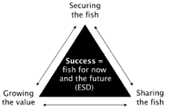
The Fisheries Victoria vision of success.
Fisheries Victoria's vision and directions underpin its projects, policies and services. The vision and strategic directions will be achieved with the cooperation and support of the community, industry and other government agencies and within the legislative framework established by the Fisheries Act and the Fisheries Regulations.
Ecologically sustainable development
All Australian governments are committed to managing fisheries according to the principles of ecologically sustainable development (Fletcher et al. 2002). These principles include:
- Ensuring that fishing is carried out in a biologically and ecologically sustainable manner
- Ensuring that there is equity within and between generations regarding the use of fish resources
- Maximising economic and social benefits to the community from fisheries within the constraints of sustainable utilisation
- Adopting a precautionary approach to management – particularly for fisheries with limited data
- Ensuring that the processes and procedures involved in management of a fishery are appropriate, transparent and inclusive. These principles have been followed during the preparation of this management plan.
Ecosystem-based fisheries management
Ecosystem-based fisheries management promotes the use of fisheries resources in a manner that does not jeopardise the benefits and opportunities of those resources for future generations. It recognises that the users and beneficiaries of fisheries resources are obliged to behave in a way that promotes the sustainability of the resource.
An ecosystem-based approach recognises the uncertainty that characterises our knowledge of fisheries and supporting ecosystems and allows for this uncertainty by applying the precautionary approach where knowledge is incomplete. The precautionary approach is based on the principles outlined in the Commonwealth Intergovernmental Agreement on the Environment 1992:
Where there are threats of serious or irreversible environmental damage, lack of full scientific certainty should not be used as a reason for postponing measures to prevent environmental degradation (Department of the Environment, Water, Heritage and the Arts 1992).
Fisheries Victoria undertakes a risk-based approach to implement ecosystem-based fisheries management so that the highest risks to fisheries and or supporting ecosystems that require treatment are addressed as a priority, planned for and risks monitored.
Fisheries co-management arrangements
Co-management is recognised in Victoria and worldwide as an integral feature of contemporary fisheries management. Co-management has been defined as "a continuum of management arrangements where responsibilities for resource management are shared between the government and user groups." This continuum extends from centralised management through consultative, cooperative and delegated management to a decentralised arrangement (DPI 2007b). It allows for user groups to have a greater say in the decision making processes affecting fisheries resources. Most recreational fisheries are at the consultative arrangement part of the continuum. However it should be noted that regardless of the co-management arrangements adopted, government must always retain the capacity to manage the fisheries resources in the public interest.
DPI is committed to effectively engaging stakeholders in decision-making and will continue stakeholder consultation through the annual Fishery Management and Stock Assessment Workshops and the Total Allowable Catch Forum.
At the time of preparing this management plan, DPI was undertaking a major review of fisheries consultative arrangements in Victoria and had released an options paper for public comment. The aim of the review was to develop a more effective and efficient framework for fisheries stakeholder engagement.
On completion of the review, DPI will implement the approved outcomes.
Regional recreational fisheries consultation meetings
The release or stocking of fish into inland waters is used to create, maintain and or enhance recreational fisheries.
DPI conducts an annual recreational fisheries consultation process (CONS) to discuss fish stocking, fish population surveys and other related recreational fisheries management issues. Annual recreational fisheries consultation process meetings are attended by representatives from DPI, the Department of Sustainability and Environment, the Fisheries Co-management Council, water and catchment management authorities, VRFish and other stakeholders as required.
The meetings:
- Review the current native and salmonid stocking plans and identify necessary modifications to them
- Identify management questions to be answered by stock or fisher surveys
- Present a state-wide perspective on current fishery management issues
- Obtain feedback from stakeholders on relevant fishery issues.
Appendix 4 provides a list of fish stockings in Corangamite fishery during 2006.
Translocation guidelines and protocols
The translocation of live aquatic organisms into and within Victoria has the potential to threaten the biodiversity and ecological integrity of Victoria's freshwater, estuarine and marine systems. These threats have flow-on consequences, potentially affecting the economic benefits provided by aquaculture; recreational and commercial fishing; domestic and international shipping; and the social and tourism benefits of being able to enjoy waters and foods free of pathogens and diseases.
The Victorian Government has developed Guidelines for Assessing Translocations of Live Aquatic Organisms in Victoria (DPI 2003b) (the Translocation Guidelines) to meet its obligations under the National Policy for the Translocation of Live Aquatic Organisms (MCFFA 1999). This policy requires all states to adopt risk-based measures to manage the environmental risks of translocating live aquatic organisms.
Proposals to stock public and private waters are assessed in accordance with the Translocation Guidelines and may require the applicant to prepare a risk assessment.
Where translocation events have similar characteristics in terms of species, associated media, and source and destination type and will be repeated, an approved translocation protocol may be developed. Translocations conducted in accordance with approved translocation protocols do not require preparation of a risk assessment by the applicant.
The Protocols for the Translocation of Fish in Victorian Inland Public Waters (DPI 2005) manage the environmental risks of existing and proposed fish stocking programs. Public water stocking programs conducted in accordance with this protocol can proceed without the need for separate risk assessments.
Impact of drought on inland fisheries management
Victoria is experiencing a sustained drought resulting in water resource scarcity. These conditions have had a substantial impact on inland fisheries and may result in:
- Mass fish deaths
- Long or short-term loss of carrying capacity of water bodies (this may be natural or as a result of a water management decision)
- Concentration of fish in small bodies of water – making them easier to legally or illegally harvest
- Changes to species composition.
Fisheries Victoria has developed a policy to mitigate impacts from the drought conditions on Victoria's inland recreational fishery. Mitigation measures include:
- Minimising the risk of mass fish deaths in stocked fisheries
- Advocating for water management regimes that support capability of drought affected water bodies to sustain existing fisheries
- Facilitating processes or provide authorisations to reduce fish biomass
- Assisting the conduct of fish salvage operations
- Supporting the nominated lead agency in fish death response
- Advising on the implication of aeration proposals
- Enacting legislative measure to improve inland recreational fisheries or supportive habitats
- Leading processes to re-establish inland recreational fisheries affected by drought.
Non-fisheries issues
Indigenous stewardship
Indigenous people have an intimate relationship with the Corangamite region which stretches back over thousands of years and continues into the future. The relationship is reflected throughout the region by recorded cultural sites including middens and scarred trees, and is based on a long tradition of stewardship, utilisation and cultural significance. For Indigenous people, cultural values are intertwined around traditional uses, spiritual connection, ancestral ties and respect for waterways, land and the resources they provide. Groups wishing to hunt and gather food for traditional ceremonies should seek permission from the relevant traditional owners of the area.
All sites of cultural significance and artefacts are protected by the Aboriginal Heritage Act 2006 (the Aboriginal Heritage Act). The Act replaces the Aboriginal cultural regime in Victoria which was governed by the Commonwealth Aboriginal and Torres Strait Islander Heritage Protection Act 1984 and the Victorian Archaeological and Aboriginal Relics Preservation Act 1972.
Key features of the Aboriginal Heritage Act include:
- The creation of the Aboriginal Heritage Council with membership consisting of traditional owners who will advise on the protection of Aboriginal heritage
- The use of cultural heritage management plans for certain development plans or activities
- The ability for registered Aboriginal parties to evaluate management plans, advise on permit applications, enter into cultural heritage agreements and negotiate repatriation of Aboriginal human remains
- Alternative dispute resolution procedures.
Enquiries in relation to registered or noted sites of cultural significance should be directed to Aboriginal Affairs Victoria. Any proposed works or use of Crown land are required to be carried out in accordance with the 'future acts' provision of the Native Title Act 1993 and the Aboriginal Heritage Act.
Customary fishing
This fisheries management plan reflects the Victorian Government's current policy on resource access by Indigenous Australians. Customary fishing practices by Indigenous Australians are not identified as a distinct type of fishing activity under current Victorian legislation. Noncommercial fishing by Indigenous Australians is therefore treated as recreational fishing.
Fisheries Victoria is presently developing a Victorian Indigenous Fishing Strategy that will inform future management arrangements regarding customary fishing by Indigenous Australians.
For specified cultural and ceremonial purposes, members of the indigenous community may be issued with general fisheries permits that allow fish to be taken beyond the recreational bag limit.
Threatened species and potentially threatening processes
The Flora and Fauna Guarantee Act 1988 (FFG Act), which is administered by DSE, provides an administrative structure to enable and promote the conservation of Victoria's native flora and fauna, and to provide for the conservation, management or control of flora and fauna and the management of potentially threatening processes.
The following items are potentially threatening processes under the FFG Act:
- Alteration to the natural flow regimes of rivers and streams
- Alteration to the natural temperature regimes of rivers and streams
- Degradation of native riparian vegetation along Victorian rivers and streams
- Increase in sediment input into Victorian rivers and streams due to human activities
- Prevention of passage of aquatic biota as a result of the presence of in-stream structures
- Removal of wood debris from Victorian streams.
The following recreational fishing species are relevant to the Corangamite fishery and are listed as threatened under the FFG Act:
- Australian grayling (Prototroctes maraena)
- Australian mudfish (Neochanna cleaveri)
- Yarra pygmy perch (Nannoperca obscura).
Carp control
European carp are a declared noxious pest in Victoria. Carp can cause significant damage to aquatic habitats and compete for habitat with native fish species.
The National Management Strategy for Carp Control 2000-2005 (Carp Control Coordination Group 2000b), developed by the Murray-Darling Basin Commission, outlines strategies to:
- Prevent the spread of carp
- Reduce the impacts of carp to acceptable levels
- Promote environmentally and socially acceptable applications of carp control programs
- Improve community understanding of the impacts of carp and management strategies
- Promote cost-efficient use of public resources in carp eradication and control programs.
Three important companion documents to the carp management strategy are:
- Future Directions for Research into Carp (Carp Control Coordination Group 2000a)
- Managing the Impacts of Carp (Koehn et al. 2000)
- Ranking Areas for Action: A Guide for Carp Management Groups (Braysher et al. 2000).
DPI invests around $160,000 annually into carp research through joint projects established by the Invasive Animals Cooperative Research Centre. These projects include:
- Development of 'daughterless' technologies for the control of invasive fish pests
- Review and development of fish-specific biocides and delivery options
- Identification and isolation of natural environmental attractants for carp
- Development of software to simulate the effectiveness of possible carp management strategies
- Integration of tagging to determine movement and migration of carp in the Murray-Darling Basin
- Development of sensory attractants for pest fish control.
Climate change
Information on the likely impacts of climate change in the Corangamite region can be found at www.greenhouse.vic.gov.au. In summary, future climate is expected to be drier and warmer, with more extreme heavy rainfall events, but an overall decrease in run-off expected by 2030.
Such changes are likely to increase stress on water bodies, primarily in the more heavily utilised Barwon and Moorabool systems, and will require best practice water efficiency management in both the surrounding rural areas and in the Ballarat and Geelong urban areas. The Barwon catchment is capped and therefore fully developed. Pressure may also increase to develop surface water resources in the Otway basin.
Fisheries resources, such as trout and river blackfish which prefer cooler water temperatures, may experience reduced viability in previously suitable areas. Reduced flows could affect river connectivity and reduce spawning cues for fish and have a deleterious effect on other aquatic organisms on which fisheries resources depend.
Climate change is a strategic priority for action by the Victorian Government. The Victorian Greenhouse Strategy and resulting actions seek to reduce greenhouse gas emissions; improve our understanding of climate change; and improve our ability to adapt to the its impacts (DNRE 2002b; DSE 2005b). The department has developed the Action Agenda on Climate Change and Greenhouse which outlines adaptation strategies including improving understanding of the likely climate change impacts (DPI 2006b).
The draft Victorian Climate Change Strategy for Fisheries and Aquaculture aims to assist fisheries managers and stakeholders in planning for, and adapting to, climate change. Through this strategy, DPI will assess the potential impacts of climate change on fisheries and will facilitate adaptation of management frameworks to future challenges and opportunities.
Coastal action plans
The Victoria Regional Coastal Action Plan (WCB 2002) was developed under the provisions of the Coastal Management Act 1995 to address coastal issues and implement the objectives of the
Victorian Coastal Strategy 2002 (Victorian Coastal Council 2002) at a regional level. The regional action plan provided for the development of the South West Estuaries Coastal Action Plan (Harty 2002) and the Central West Victoria Estuaries Coastal Action Plan (DSE 2005a).
Coastal action plans provide a strategic framework for the development of individual estuary management plans. Coastal action plans recommend the development of estuary management plans for all estuaries in the Corangamite region.
Within the Corangamite region, the Gellibrand River Estuary and Wetlands Management Plan (O'May and Wallace 2001), Anglesea Estuary Management Plan (Surf Coast Shire 2004a), and Painkalac Estuary Management Plan (Surf Coast Shire 2004b) have been completed. Estuary management plans will be developed for the remaining estuaries in the coming years.
Estuary management plans provide a basis for coordinated protection and enhancement of the environmental values of the area while considering the social and economic values that are of great importance to the local and wider community.
Estuary management plans address a range of issues that can be described in the following themes:
- Habitat and species conservation
- Water quality
- Sedimentation and erosion
- Cultural heritage
- Development
- Recreation
- Flooding
- Estuary entrance – artificial river mouth openings
- Fishing
- Visual amenity.
Estuary management plans will recognise the importance of commercial and recreational fishing activities and the links between productivity of fisheries resources and other factors including water quality and artificial openings.
Regional catchment strategy
The integrated management of all natural assets in the Corangamite region occurs under the direction provided by the Catchment and Land Protection Act 1994 (CaLP Act). Under the CaLP Act, the CCMA has the responsibility to prepare a Regional Catchment Strategy (RCS) for the Corangamite region and to coordinate and monitor its implementation.
The Corangamite RCS 2003-2008 (CCMA 2003) provides long-term direction for managing the future of land, water resources, biodiversity and seascape of the Corangamite region and is the foundation for investment decisions to ensure improved natural resource outcomes.
The RCS framework is supported by a series of sub-strategies and plans developed to provide the direction for specific asset and threat management programs. These plans include the Corangamite Regional River Health Strategy (CCMA 2006); Native Vegetation Plan (CCMA 2005); Salinity Action Plan (Nicholson et al. 2006); Soil Health Action Plan (DNRE 2001); Rabbit Action Plan (DNRE 2000a); and the Weed Action Plan (DNRE 2000b).
Under the Securing Our Water Future (DSE 2004), CMAs are appointed as the community caretaker of rivers and water resources. The CCMA will be responsible for the operational management of the environmental water reserve in the region. The CCMA has waterway, rural drainage and floodplain management roles and responsibilities as defined in the Water Act 1989 (the Water Act).
Regional river health strategy
The Corangamite Regional River Health Strategy (Corangamite RRHS) (CCMA 2006) provides broad level strategic direction for the future management of waterways in the CCMA area. This five-year Strategy is a guide government investment and, regionally, will direct the development of an annual works program. The Corangamite RRHS sits jointly under the Corangamite RCS and the Victorian River Health Strategy (DNRE 2002c). It provides the necessary link between the objectives of the Victorian government and community and is an integral part of the Victorian legislative framework to protect the State's waterways (CCMA 2003).
The Corangamite RRHS combines all elements of river management in a single document. It integrates river health programs into a multidisciplinary framework and considers water quality and quantity, flow, in-stream and riparian flora and fauna, fisheries and recreation (CCMA 2004).
Fishing is listed as a high social value in the Corangamite RRHS and many of its actions will have positive outcomes for recreational fishing.
The CCMA has developed a number of objectives aimed at enhancing river health such as improving fish passage, sediment control, environmental flows, riparian zones and water quality. Other goals include reducing bed and bank erosion and strategic willow and weed management. These objectives will have positive outcomes for all aquatic ecosystems generally including fisheries resources.
Local government
The Corangamite region includes all or part of the municipalities of Cities of Ballarat and Greater Geelong, the Borough of Queenscliffe, the Shires of Moorabool, SurfCoast, Corangamite, Golden Plains, Colac Otway and Moyne.
Local governments work in partnership with the CCMA to set priorities and implement the Corangamite RRHS. Local governments also have the following roles and responsibilities in relation to fisheries issues:
- Incorporate river restoration and catchment management objectives and actions into statutory planning processes
- Undertake floodplain management and flood warning in accordance with the Victoria Flood Management Strategy
- Develop and implement urban storm-water plans
- Manage rural drainage schemes where appropriate
- Facilitate local industries involvement in river restoration and catchment management activities
- Provide local support for local action groups.
Water supply
The movement, regulation and delivery of water resources from rivers, lakes and groundwater supplies are overseen by a number of public and private stakeholders within the Corangamite region.
Rural Water Authorities are delegated under the Water Act to licence and regulate the extraction of water for consumptive uses including irrigation and commercial use.
Water planning is affected through bulk water allocations and licensing processes administered by Southern Rural Water under the Water Act. The water utilities, namely Central Highlands Water, Wannon Water and Barwon Water, are involved in water resource management through bulk water entitlements, planning and implementation of water supply augmentations, wastewater services and water demand management.
Urban water services
There is significant demand for water resources to supply the urban centres of Geelong, Ballarat and the towns along the Great Ocean Road. The urban water authorities and local government have an important role in ensuring environmental flow regimes are maintained.
Barwon Water is Victoria's largest regional urban water authority. Barwon Water provides water and sewerage services to more than 270,000 permanent residents in an area of more than 8100 square kilometres.
The Barwon River system, from its Otway Ranges catchment, supplies approximately 70 per cent of the water for Geelong, Bellarine Peninsula and Surf Coast via the Wurdiboluc Reservoir and water treatment plant. The balance is supplied from catchments on the Moorabool River system which provide water to the Moorabool water treatment plant at She Oaks, north of Lethbridge. The Moorabool system also provides water to Anakie, Staughton Vale, Bannockburn, Gheringhap, Teesdale, Shelford and Inverleigh. Some river systems in the Otway Coast Basin, such as the Gellibrand River, Barham River, and Painkalac Creek, are also utilised for urban and rural consumption.
Supplies in the Colac and Otway regions are drawn from five separate sources, all located in the forested catchments of the Otway Ranges. The Colac system provides water to urban and rural districts extending as far north as Cressy. Gellibrand, Aireys Inlet/Fairhaven, Apollo Bay/Skenes Creek and Lorne each have their own supply system.
Domestic customers comprise 92 per cent of the customer base with industrial and commercial customers accounting for the remainder. Industrial and commercial customers use around 35 per cent of metered consumption.
Environmental water reserve
The environment's share of water is the environmental water reserve (EWR). The EWR is not a separate physical construction like a dam. It can be held in existing water supply storages and released into a waterway or it can be run-of-river flow.
The EWR is used to maintain the environmental values of the water system and the other water services that depend on environmental condition and to sustain biodiversity, ecological functioning and water quality.
Water in the EWR is legally protected under the Water (Resource Management) Act 2005 and is held by the Crown.
In establishing or enhancing the EWR, the Victorian Government will ensure existing water entitlement holders are recognised. In priority catchments, the Government will assess the adequacy of the EWR and, in consultation with the community, improve it where necessary.
Stream flow management plans
Stream flow management plans are developed with the aim of sharing the available water sustainably between all users. This ensures that the licensed diverters and the environment receive the water they need.
Stream flow management plans include management arrangements that:
- Recognise historical rights to water in the catchment
- Establish environmental flows, including minimum flows and other aspects of the flow regime
- Outline conditions that are placed on licences to protect the environment or to protect other water users
- Define the total volume of water that can be taken under licence in any year (a cap on diversions)
- Establish trading rules that will apply to transfers of water entitlements into, and within, the catchment.
The plan to manage the Corangamite fishery
Scope of the plan
The overall purpose of this management plan is to formalise management arrangements for the recreational Corangamite fishery in accordance with the provisions of the Fisheries Act, the Ministerial guidelines, and consistent with the principles of ecologically sustainable development (ESD).
To achieve its purposes, the plan:
- Specifies goals, objectives, strategies and actions for management of fisheries resources across the Corangamite fishery
- Builds on community feedback and identifies the most valued recreational fishing assets in the Corangamite fishery and describes the highest priority strategies and actions to mitigate issues and risks that could impact on these fishing assets
- Identifies actions recommended by stakeholders and other management agencies to manage other values and uses of waterways, including the identification and minimisation of potential adverse impacts on fish habitat and fisheries.
The process of producing this fishery management plan is described in Appendix 5.
Definition of the fishery
The Corangamite fishery is defined as all inland waterways (estuaries, lakes and rivers) in the Otway, Moorabool, Barwon and Corangamite basins. The fishery aligns with the geographical boundaries of the CCMA region and does not include marine waters (Figure 1).
The Corangamite fishery does not include commercial bait fishing and aquaculture as these activities are managed by the commercial and aquaculture licensing processes respectively or the recreational or commercial eel fishery which are managed under the Victorian Eel Fishery Management Plan (DNRE 2002a).
Duration of the plan
This management plan came into effect following a declaration by the Minister via a notice in the Victoria Government Gazette and provides the basis for the management of the Corangamite fishery for a period of at least five years from the date of declaration.
Preparation of a new fishery management plan will begin with a review of the goals, objectives, strategies, performance indicators and targets of the current plan. The need for new or amended objectives as a result of monitoring and research information obtained will be considered.
Amendments to this management plan will be made in accordance with the requirements of the Fisheries Act.
Implementation of the plan
Most fishery management measures for the Corangamite fishery will initially remain unchanged with a focus on establishing programs to monitor the status of key recreational fishing species and identifying key environmental threats to fisheries resources.
If information from these programs indicates a need to alter fishery management arrangements to ensure sustainable use or to meet changing demands for recreational fishing opportunities, changes will be considered in consultation with stakeholders.
Proposed changes to the Fisheries Regulations may be subject to a Regulatory Impact Statement process under the provisions of the Subordinate Legislation Act 1994, which includes extensive consultation with stakeholders.
The Corangamite Fishery Reference Group
The Corangamite Fishery Reference Group (the Fishery Reference Group) will be established to work with DPI to deliver the desired management outcomes for the Corangamite fishery. It is proposed that the Fishery Reference Group include representatives from Fisheries Victoria, VRFish, Barwon Water, Southern Rural Water and the CCMA. Other groups or individuals may be engaged as required.
The Fishery Reference Group will advise the Executive Director Fisheries Victoria with respect to the coordination of activities and projects in support of management plan actions, strategies and objectives, including monitoring implementation. The Fishery Reference Group will facilitate partnerships with other agencies to develop programs, review the outcomes of research and provide recommendations on future research directions.
Fisheries Victoria will establish the Fishery Reference Group within twelve months of declaring the Plan. Fishery Reference Group Terms of Reference will be issued by the Executive Director Fisheries Victoria.
Ongoing implementation of this management plan will require action by DPI, recreational fishers, VRFish and other stakeholders to establish the required fishery monitoring and research programs, to carry out day-to-day management activities and to ensure compliance with fishery management arrangements.
Key actions required to facilitate implementation of this plan are summarised in the section entitled Outcomes of the Corangamite Fishery Management Plan.
Costs of implementation
Costs to implement specific actions in this management plan are described in the section entitled Outcomes of the Corangamite Fishery Management Plan.
Management goal and objectives Goal
The goal of this plan is to manage recreational fishing in the Corangamite fishery in accordance with principles of ESD.
The aim of ESD is to enable the ongoing use, conservation and enhancement of the fisheries resources such that ecological processes are maintained into the future and, where possible, usage is enhanced. In the context of this management plan, ESD involves: management, monitoring and research to demonstrate the sustainable harvest of fisheries resources; identification of the habitats and aquatic environments on which fisheries resources depend; and, enhancing social and economic benefits for all Victorians.
Objectives
- Biological - To conserve and ensure sustainable use of key fish stocks across the Corangamite fishery. The biological objective considers the sustainability of harvesting fish species and ecosystem components such as bait, by-catch and impacts on non-target fish species.
- Social - To maintain and where possible enhance recreational fishing opportunities across the Corangamite fishery. The social objective considers the economic and social benefits that recreational fishing provides to the Corangamite community.
- Environmental - To promote protection and where possible enhancement, of the habitats and environments which are essential for production or maintenance of fisheries resources across the Corangamite fishery. The environmental objective considers the influence of habitat and environment factors such as catchment and riparian activities affecting water quality, water extraction affecting water levels and flows, and weirs that act as a barrier to fish migration. Although the potential risks associated with these environmental and habitat components are significant for the Corangamite fishery, these components are primarily managed by agencies other than DPI. For this reason, this plan provides information on the environment and habitat requirements of fisheries resources to the relevant resource manager to assist with management decisions.
- Governance - To achieve maximum community participation, understanding and support for the management of fisheries resources across the Corangamite fishery. A key component of this objective is the plan's implementation and the public participation in its preparation (i.e. public meetings, submissions, stakeholder steering committee). The actions, performance measures and targets for strategies, combined with reporting against these performance measures, will address the management plan's governance objective.
Performance indicators
Performance indicators are provided for actions that Fisheries Victoria has responsibility for implementing. These indicators provide a means of tracking progress on an ongoing basis.
As part of the ongoing implementation of this management plan, performance indicators may be further refined using data from monitoring programs and surveys.
Performance indicators are not provided for actions that other agencies are responsible for implementing.
Targets
Targets provide a longer-term measure for the objectives of this management plan and should be achieved through its successful implementation.
Funding arrangements
Fisheries Victoria will fund from its program budget the management plan actions required to meet the objectives of the Fisheries Act 1995. Actions not required to meet these objectives will require funding to be obtained from other sources (e.g. the Recreational Fishing Licence Trust Account or through cost recovery arrangements).
Identification and prioritisation of strategies and actions
In preparing this management plan, the risks to the biological, social, environmental and governance components of the Corangamite fishery were considered in accordance with the principles of ESD.
The themes are presented under the following chapters:
- Objective 1: Sustainable use of fishery resources
- Objective 2: Recreational fishing opportunities
- Objective 3: Protection and enhancement of fish habitat
- Objective 4: Compliance with fishery management arrangements
Further Information
For further information on this management plan or to comment on its implementation or recreational fishing in general, contact the Customer Service Centre telephone 136 186
Objective 1: Sustainable use of fishery resources
Strategy 1: Demonstrate the sustainable use of key recreational fishing species
The biological objective of this management plan is to conserve and ensure the sustainable use of key fish stocks across the Corangamite fishery.
Managing the sustainable use of key recreational fishing species requires knowledge of the likely abundance, size compositions and stock structures of fish populations, the fishing pressure exerted on them and an understanding of broader environmental impacts on recruitment.
This information will assist resource managers to make adaptive management decisions to ensure recreational fishing pressure is maintained at sustainable levels.
Limited fisheries monitoring is conducted in the rivers, lakes and estuarine environments of the Corangamite fishery and only a small number of netting and creel surveys have been conducted. This plan aims to establish relevant fishery monitoring programs and maintain current management arrangements where appropriate.
Given the high cost associated with collecting fishery data, there are limits to the number and scale of monitoring programs. Fishery monitoring programs will focus on the key native recreational fishing species in the Corangamite fishery as identified through public consultation:
- Black bream
- Estuary perch
- River blackfish
Sustainable use of estuarine fisheries
The key recreational estuarine species that require fishery monitoring are black bream and estuary perch. Priority will be given to establishing research fishers specifically targeting black bream and estuary perch in the Curdies River.
A cost-effective and efficient fishery monitoring technique is a research angler diary program. Information collected using research angler diary programs over a number of years can provide fishery managers with scientifically valid information on catch and effort that can be used as a basis for reviewing current fisheries management arrangements. Changes to fisheries management arrangements need to be taken in the context of state-wide issues.
Ongoing research angler diary programs provide a time series of data on catch rates and size composition for key recreational fishery species and an indication of fluctuations in year class abundance and recruitment. Information on prerecruit (i.e. fish smaller than the legal size) and recruited fish will assist fishery managers by providing the capacity to predict changes in fishery conditions and to plan appropriate management responses.
This ongoing program will rely on experienced and highly skilled volunteer fishers undertaking research fishing trips targeting specific fish species in accordance with prescribed methods. Hook size, bait and fishing location are chosen within identified estuaries to ensure a representative sample of the targeted species in the waterway is obtained. The program will collect information on species abundance and length and otoliths will be used to establish population age profiles.
Information from fishing club records and creel surveys may also be used when undertaking reviews of data collected from the research angler diary program.
Sustainable use of freshwater fisheries
River blackfish are native to the Corangamite region and are a highly valued recreational fishing species, particularly in the Gellibrand and Carlisle rivers and tributaries. The greatest threats to river blackfish are siltation of streams and removal of habitat (DPI 2003a).
Monitoring the recreational harvest of this species and knowledge of its abundance is limited. Information on recreational harvest will improve understanding of the stock status and the sustainability of current fishing controls and provide valuable information to guide fisheries management decisions.
Actions
- Fisheries Victoria will, subject to available funding, develop a research angler diary program to provide information on catch rates and size composition of black bream and estuary perch in the Curdies River (or, if necessary, an alternative).
- Fisheries Victoria will, subject to available funding, develop a research angler diary program to provide information on catch rates and size composition of river blackfish in the Gellibrand and Carlisle rivers and tributaries (or, if necessary, an alternative).
Performance indicators
- A research angler diary program for black bream and estuary perch is established within two years following the declaration of this management plan.
- A research angler diary program for river blackfish is established within two years following the declaration of this management plan.
- A report detailing the results of the research diary programs is published within five years of the declaration of this management plan.
Target
The recreational harvest of key species is sustainably managed in response to information collected from research angler diary programs.
Strategy 2: Monitor catch composition and trends for all recreational fishing species
The key native fisheries species in the Corangamite fishery are black bream, estuary perch and river blackfish. Other fishery species such as trout, snapper, flathead, redfin and King George whiting are also popular.
Fisheries Victoria collects catch and effort information for commercially harvested species including bait species. This information can be used to detect changes in abundance and fishing pressure on commercially harvested species and is used to inform decisions regarding fishery management arrangements.
The information gathered through ongoing fisheries management processes including statewide risk assessments, combined with the public consultation processes, indicates that other species in the fishery are not presently considered vulnerable to be over-fished. The aim of this strategy is to continue to monitor fishery trends and to detect species over-fished and to adapt fisheries management where necessary.
Action
Fisheries Victoria will, subject to available funding, establish a general angler diary program to determine species composition of catches and allow ongoing assessment of fishery trends.
Performance indicators
- A general angler diary program is established within two years following the declaration of this management plan.
- A report detailing the results of the general angler programs is published within five years of the declaration of this management plan.
Target
The recreational harvest of key species is sustainably managed in response to information collected from general angler diary programs.
Objective 2: Recreational fishing opportunities
Strategy 3: Maintain stockenhanced fisheries
Populations of brown and rainbow trout are widespread throughout the Corangamite fishery and provide for popular recreational fishing opportunities in the region. Fisheries for these species in rivers are primarily based on selfsustaining wild populations whilst those in lakes are primarily based on stocked fish.
Rivers in the Corangamite fishery are not stocked because of the effect it may have on existing selfsustaining wild populations, particularly in rivers and streams where habitat and environmental conditions are unfavourable. Research has confirmed that the benefits of stocking trout into these self-sustaining wild populations are generally minimal (Stoessel 2008).
In 2006, Fisheries Victoria released approximately 83,600 trout into lakes across the Corangamite fishery (Appendix 4). Maintaining these stockenhanced fisheries generates important social and economic benefits (Henry and Lyle 2003).
Action
Fisheries Victoria will continue to stock fish in the Corangamite fishery consistent with the outcomes of the Regional Fisheries Consultations Meeting.
Performance indicator
Subject to unforseen factors, fish stocking in the Corangamite fishery is consistent with the annual Regional Fisheries Consultations Meeting Outcomes report.
Target
Fish stocking is consistent with the targets identified in the Regional Fisheries Consultations Meeting Outcomes report.
Strategy 4: Classify waters using the fisheries stream classification model
Fisheries Victoria has worked with recreational fishers to prepare a fisheries Stream Classification Model (SCM) which can be used as a working tool to classify rivers, streams and impoundments across Victoria as salmonid, native or mixed fisheries. The SCM will be a useful tool in promoting Victoria's inland fisheries.
The SCM will initially be applied to rivers, streams and impoundments managed under the North East Fishery Management Plan (DPI 2007a). Classification of the North East fishery will be the first step in the state-wide application of the SCM.
The SCM will be an important part of fisheries management in Victoria and is in aligned with Fisheries Victoria's commitment to secure, grow and share potential benefits from Victoria's inland fisheries with the wider community.
Action
The Stream Classification Committee will develop and implement the SCM.
Performance indicator
The SCM will be finalised by mid-2009 and applied to the Corangamite fishery within four years of the declaration of this management plan.
Target
Classifying waterways as salmonid, native or mixed fisheries will inform other management agencies how they are managed by Fisheries Victoria. Stream classification will allow Fisheries Victoria to secure, grow and share benefits from Victoria's inland fisheries with the wider community.
Strategy 5: Improve access for boat-based fishing
Improved fisher access was identified during the public consultation process as a way to greatly improve recreational fishing opportunities.
The need for new or improved boat launching facilities has been raised in public forums for the Gellibrand estuary and lakes Bullen Merri, Purrumbete and Tooliorook. Adequacy of boat launching infrastructure in other areas not identified during public consultation may require review.
Depending on the waterway, the responsibility for providing and maintaining boat launching facilities rests with agencies including Parks Victoria, committees of management, water authorities and local government.
This management plan supports applications for new or upgrading of existing infrastructure that meet the following criteria:
- The proposal must have the support of the relevant natural resource management agency (i.e. land manager and or water authority)
- The proposal must consider the impact of works on the environment and, where possible, minimise adverse impacts
- The proposal must consider the impact of variations in water levels, particularly during times of drought or estuary closure
- The proposal must align with existing infrastructure such as roads
- The proposal must benefit other recreational boating groups.
Proposals for funding the provision of new or upgrading of existing boat launching facilities are made through Marine Safety Victoria's Boating Safety and Facilities Program.
Action
VRFish will liaise with fishers, land managers and water authorities to identify and submit applications for new or the upgrade of existing boat launching facilities.
Strategy 6: Improve access for land-based fishing
Land-based fisher access is important and may be the only means of fishing some waterways in the Corangamite fishery.
Work to upgrade roads and tracks is prioritised by land managers and is based on available funding and the needs of the community. The most effective way to achieve improvements to roads and tracks is to influence the prioritisation process by engaging land managers and providing information on the most valued recreational fisheries.
Urbanisation and development around estuarine environments can alienate available access points to recreational fishers. Opportunities may exist for planning by local governments to maintain fisher access in proposals for housing estates and other ventures that privatise land adjacent to fisheries resources.
Fishers identified their lack of knowledge regarding the legal status of land adjoining waterway (for example, Crown frontages, private land) and their right of access as important issues. In its policy, Access for Recreational Fishing (VRFish 2004), VRFish reviewed this issue and made a number of recommendations to improve fisher understanding of access issues across the state.
A list of issues (including access) that were raised during the public consultation phases of this management plan is provided in Appendix 6. This list will assist VRFish in setting future priorities when engaging other agencies.
Actions
- VRFish will liaise with fishers, land managers and water authorities to identify and promote new or the upgrade of existing access tracks and facilities.
- VRFish will implement actions in Access for Recreational Fishing to improve fishers understanding of their rights to access land adjoining recreational fisheries.
Strategy 7: Encourage responsible recreational fishing behaviour
Access to Victoria's fish stocks for recreational purposes brings with it a responsibility to act in an acceptable manner and demonstrate stewardship of the resource. To support Fisheries Victoria in promoting this responsibility, VRFish developed the Victorian Recreational Fishing Code of Conduct (the Code of Conduct). This document provides guidance to recreational fishers on issues such as:
- Protecting the environment
- Respecting the rights of others
- Attending fishing gear
- Being aware of and complying with fishing restrictions
- Returning of unwanted fish to the water
- Valuing fish caught
- Passing on fishing and local knowledge to new fishers.
The Code of Conduct recognises that damage to the environment can indirectly harm fisheries resources and the environment generally. The Code of Conduct contains recommendations regarding the appropriate disposal of rubbish, unwanted fishing gear and bait, and recommends taking care of the environment and maintaining an awareness of impacts to plants and animals when fishing.
Details on the Code of Conduct are available from the VRFish website at www.vrfish.com.au.
Action
VRFish will promote the Victorian Recreational Fishing Code of Conduct.
Strategy 8: Monitor fishing values or preferences in the Corangamite fishery
Recreational fishing-based tourism is a major contributor to economic activity in the Corangamite region. Public consultation suggested that several unique aspects such as the productive lakes and the stream-based river blackfish and searun brown trout fisheries are some of the main attractions of the Corangamite fishery.
Surveys of recreational fishers are needed to understand fisher demographic profiles satisfaction and preferences and to evaluate the return on investment in recreational fishing. These surveys should be conducted periodically to first benchmark and then detect changes over time.
This information is required to identify fisheries management actions needed to satisfy the aspirations of recreational fishers.
The most cost-effective collection of this information is likely to be through periodic surveys at fishing access points for visiting and local non-club fishers and direct surveys of local fishing club members.
Action
Fisheries Victoria will, subject to available funding, undertake periodic surveys to provide information on fishing satisfaction and preference.
Performance indicators
- A benchmark survey is conducted within two years of management plan declaration and a follow-up survey is conducted within four years of declaration.
- A report detailing the survey results is published within five years of management plan declaration.
Target
Fisheries Victoria to use survey results to evaluate possible fishery management actions to satisfy recreational fishing aspirations.
Objective 3: Protection and enhancement of fish habitat
Within the Corangamite fishery, five priority issues are identified as potential threats to the habitat or ecological processes for key recreational fishing species:
- Altered water flows and diversions and artificial modifications of lake levels
- Poor water quality resulting from catchment related processes
- In-stream and riparian habitat
- Lake/impoundment water levels
- Artificial river mouth openings.
Water flow
The amount and timing of downstream flow through waterways can have a major impact on the production of fishery resources. In addition to natural variation, water flows change as a result of extraction and diversion for irrigation and urban water supply needs.
Typical natural flow patterns in waterways in the Corangamite region involve high flows in winter and relatively low flows in summer. Dams, weirs, water extraction and other activities modify natural flow regimes. Many fishery species rely on these seasonal changes to stimulate spawning and migration and changes to seasonal flow regimes can have implications for the survival of these species.
High river flows are also important in flooding estuarine environments, as this process sustains important fringing wetland communities and associated food chains. The build up of water in an estuary can lead to a more substantive breach of its entrance and resulting in a greater flush of anoxic water.
Water quality
Water quality can influence the carrying capacity of waterways for many fishery species. Carrying capacity is also determined by the quality of instream habitat.
Poor water quality, including eutrophication, increased sedimentation and turbidity that result primarily from catchment-related processes such as land clearing, can have a significant impact on fisheries resources, particularly at the lower reach of a river.
For example, stock access, removal of riparian vegetation and land clearing can lead to increased erosion of nutrient-laden sediments that result in algal blooms and sedimentation. Both outcomes can lower the suitability of habitat for fisheries resources.
Natural variation in fish abundance often occurs between seasons as a consequence of climateinduced fluctuations in stream flow and temperature. For some native and introduced fish species, particularly brown trout, water temperature strongly influences reproductive capacity and limits distribution.
In-stream and riparian habitat
In-stream habitat, such as logs and branches, provide important habitat for many fishery species including river blackfish and black bream. Woody material accumulates in rivers, streams and wetlands and provides refuge and spawning sites for some fishery species and for a wide variety of their invertebrate prey. Loss of this vital habitat component can be detrimental to fishery species.
Evidence from a study conducted on behalf of the CCMA indicates that replacement of in-stream woody habitat in the Barham River estuary has provided habitat for black bream and yellow-eye mullet (McGucken 2006).
Riparian land is any land that adjoins or directly influences a body of water. It includes the land immediately alongside waterways, wetlands and river floodplains which connect with the river in times of flood.
Well-vegetated riparian land plays an important role in improving water quality by trapping sediment and nutrients from the catchment, reducing erosion of banks, maintaining natural light and temperature levels within streams and providing food and habitat for aquatic species (Price et al. 2004). It is therefore important to replant riparian land with native vegetation as soon as possible following willow removal.
Lake/impoundment water levels
The primary purpose of impoundments is to supply agricultural or urban water requirements. Water volumes will fluctuate in response to water demands and climatic patterns. During drought, water levels can remain low for extended periods and may be completely dry. These fluctuations can have large impacts on the fish populations and the fishery. For example, populations of self-recruiting species can be significantly reduced.
Artificial river mouth openings
Artificial openings of river mouths must be managed in a way that maintains the ecological integrity of the system and recognises the economic costs that flooding can have on infrastructure and agricultural land.
Unauthorised openings may result in the deaths of fish or other aquatic species. These may take many years to recover to previous levels of diversity and abundance.
In response to past unauthorised openings and the need for clear and consistent guidelines, an Estuary Entrance Management Support System (EEMSS) has been developed (Arundel 2006). This initiative was supported by Deakin University, Western Coastal Board, Environment Protection Authority, the CCMA, Parks Victoria, DSE and the Victorian Coastal Council. The EEMSS ensures that decisions regarding estuary openings are transparent and consider relevant environmental, social, cultural and economic issues.
Strategy 9: Habitat advocacy for key recreational fishing species
Estuarine and inland waters are facing increasing pressures from human population growth and associated agricultural, industrial, urban and tourism development. There is increasing evidence worldwide that the sustainable use of fishery resources is dependent on controlling the impacts of fishing on fish stocks and on maintaining the integrity of the habitat and the ecological processes they support.
The purpose of this strategy is to facilitate the dissemination of information on environmental requirements including habitat, food and life history that affect the productivity of fish species.
The responsibility for implementing programs to improve habitat and water quality rests primarily with DSE, the Environment Protection Authority, Melbourne Water and the Commonwealth Department of Environment, Water, Heritage, and the Arts. Fisheries Victoria provides advice on the environmental requirements of recreational fishery species which can be used by other agencies to inform policies and programs such as the Corangamite Regional River Health Strategy (CCMA 2006).
Action
Fisheries Victoria will provide advice on environmental requirements of key recreational fishing species to other agencies.
Performance indicator
Advice on the environmental requirements of recreational target species is provided to other agencies to inform policies and programs.
Target
Information regarding the environmental requirements of recreational target species is used by other agencies to develop policy and investment programs.
Objective 4: Compliance with fishery management arrangements
Strategy 10: Educate fishers on sustainable fishing
Community expects fishery resources to be managed at sustainable levels. The Fisheries Act and the Fisheries Regulations provide the legislative framework to assist in the protection of fishery resources. Compliance with this legislation is achieved through a combination of maximising voluntary compliance and creating a deterrent to illegal activities (e.g. penalty infringement notices, prosecution).
Voluntary compliance is best achieved with effective education programs that promote a sense of shared responsibility for maintaining healthy fisheries for future generations. Fisheries Victoria is committed to fisheries education and to promoting and supporting close and ongoing cooperation between fishers and DPI.
Fisheries Victoria education programs are often complemented by community education activities of other organisations, including VRFish and Fishcare. Both organisations foster responsible fishing practice and play an important role in fisheries education.
Further information on Fishcare and VRFish is available at www.fishcare.org.au and www.vrfish.com.au, respectively.
Action
Fisheries Victoria will continue to provide fisheries education and information to the community.
Performance indicator
Education material is provided at all DPI Go Fishing in Victoria Family Fishing Events.
Target
Implementation of education programs supports sustainable fishing.
Strategy 11: Enforce fishing regulations
Fisheries Victoria delivers a range of fisheries compliance services from detection and apprehension of illegal fishers to providing education and information that maximises voluntary compliance.
Routine and targeted patrols provide important opportunities for communication and engagement with fishers and discourage illegal activities by providing a physical presence. Issuing penalty infringement notices is also a deterrent to illegal activities.
Patrolling is complemented by targeted investigations, including covert operations to disrupt and dismantle large-scale organised crime.
DPI also operates a 24-hour, 7-day a week, statewide offence reporting service – 13 FISH (Phone: 13 3474) on which members of the public who are concerned about suspected illegal activities are encouraged to report these matters.
Actions
- Fisheries Victoria will, subject to available funding, continue to promote community reporting of suspected illegal fishing activities through 13 FISH.
- Fisheries Victoria will continue to use information derived from fishery compliance risk assessments, 13 FISH reports and historical patrol activities to prioritise, plan and target patrols, inspections and compliance operations to achieve a high level of compliance with the Fisheries Regulations.
Performance indicator
Compliance with the Fisheries Regulations is greater than 90 per cent.
Target
Compliance programs ensure ongoing access to recreational fish species.
Outcomes of the Corangamite Fishery Management Plan
References
Allen, GR 1989,Freshwater fishes of Australia, TFH Publications Inc, Brookvale.
Arundel, H 2006,Estuary Entrance Management Support System, H Arundel (ed) Report for the Glenelg Hopkins Catchment Management Authority 116 p including CD, Hamilton, Victoria.
Braysher, M, and Barrett, J 2000, Ranking Areas for Action: A Guide for Carp Management Groups, Murray-Darling Basin Commission, Canberra.
Cadwallader, PL, and Backhouse, GN 1983, A guide to the freshwater fish of Victoria, Victorian Government Publishing Office, Melbourne.
Carp Control Coordination Group 2000a,Future Directions for Research into Carp, Murray-Darling Basin Commission, Canberra.
Carp Control Coordination Group 2000b, National Management Strategy for Carp Control 2000-2005, Murray-Darling Basin Commission, Canberra.
Cappo, MC 1987, The biology and exploitation of Australian salmon in South Australia, SAFISH vol. 12, no. 1, pp. 4-14.
Cashmore, S, Conron, S, and Knuckey I (eds) 2000, Black Bream – 1998, Fisheries Victoria Assessment Report No. 24, Marine and Freshwater Resources Institute, Queenscliff.
CCMA 2003, Corangamite Regional Catchment Strategy 2003-2008, Corangamite Catchment Management Authority, Colac.
CCMA 2004,Draft Corangamite Regional River Health Strategy, Corangamite Catchment Management Authority, Colac.
CCMA 2005, Corangamite Native Vegetation Plan. Corangamite Catchment Management Authority, Colac.
CCMA 2006, Corangamite Regional River Health Strategy, Corangamite Catchment Management Authority, Colac.
Chubb, CF, Potter, IC, Grant, CJ, Lenanton, RCJ and Wallace, J 1981, 'Age structure, growth rates and movements of sea mullet, Mugil cephalus L., and yellow-eye mullet, Aldrichetta forsteri (Valenciennes), in the Swan-Avon river system, Western Australia', Australian Journal of Marine and Freshwater Research vol. 32, pp. 605- 628.
DNRE 2000a, Corangamite Rabbit Action Plan – Strategic Rabbit Management 2001-2006, Corangamite Catchment Management Authority, Colac.
DNRE, 2000b, Corangamite Weed Action Plan 2001- 2004, Corangamite Catchment Management Authority, Colac.
DNRE 2001,Corangamite Soil Health Action Plan: A Component of the Corangamite Regional Catchment Strategy, Department of Natural Resources and Environment, Melbourne.
DNRE 2002a, Victorian Eel Fishery Management Plan, Department of Natural Resources and Environment, Melbourne.
DNRE 2002b,Victorian Greenhouse Strategy, Department of Natural Resources and Environment, Melbourne.
DNRE 2002c, Victorian River Health Strategy, Department of Natural Resources and Environment, Melbourne.
DPC 2005, Growing Victoria Together - A vision for Victoria to 2010 and beyond, Department of Premier and Cabinet, Melbourne.
DPI 2003a,Freshwater Fish of Victoria - Blackfish, Fisheries Note, Department of Primary Industries, Melbourne.
DPI 2003b, Guidelines for Assessing the Translocation of Live Aquatic Organisms in Victoria, Department of Primary Industries, Melbourne.
DPI 2005, Protocols for the Translocation of Fish in Victorian Inland Public Waters, Department of Primary Industries, Melbourne.
DPI 2006a, Responding To The Impacts Of Drought And Its Consequences On Inland Recreational Fisheries Policy, Department of Primary Industries, Melbourne.
DPI 2006b, Action Agenda on Climate Change and Greenhouse; Growing Sustainable Primary Industries, Department of Primary Industries, Melbourne.
DPI 2007a, North East Fishery Management Plan, Fisheries Victoria Management Report Series No. 48, Department of Primary Industries, Melbourne.
DPI 2007b, Victorian Fisheries Consultative Arrangements Review – Discussion Paper, Fisheries Victoria Management Report Series No. 51, Department of Primary Industries, Melbourne.
DPI n.d., Victorian Recreational Fishing Guide, Department of Primary Industries, Melbourne.
DEWHA 1992, Intergovernmental Agreement on the Environment. Department of Primary Industries, Canberra.
DSE 2004, Securing Our Water Future, Department of Sustainability and Environment, Melbourne.
DSE 2005a, Central West Victoria Estuaries Coastal Action Plan, Western Coastal Board, Geelong.
DSE 2005b, Victorian Greenhouse Strategy Action Plan Update, Department of Sustainability and Environment, Melbourne.
Edgar, G, Hammond, L and Watson, G 1993, Consequences for commercial fisheries of loss of seagrass beds in Southern Australia, Final Report to the Fisheries Research and Development Corporation, No. 88/91, Victorian Institute of Marine Sciences, Queenscliff.
Environment Australia 2001, A Directory of Important Wetlands in Australia, 3rd Edition, Environment Australia, Canberra.
Fletcher, WJ 1979, 'Effects of Salmo trutta on Galaxias olidus and Macroinvertebrates in Stream Communities', MSc thesis, Monash University, Clayton.
Fletcher, WJ, Chesson, J, Fisher, M, Sainsbury, KJ, Hundloe, T, Smith, ADM, and Whitworth, B 2002, National ESD reporting framework for Australian Fisheries: The 'How To' Guide for Wild Capture Fisheries, Final Report for Fisheries Research and Development Corporation Project 2000/145, Fisheries Research and Development Corporation, Canberra.
Gomon, MF, Glover, JCM and Kuiter, RH (eds) 1994, The Fishes of Australia's South Coast, State Print, Adelaide.
Hall, DN 1984, Commercial Fishery Situation Report: Lake Tyers, Gippsland, Fisheries and Wildlife Service, Victoria, Commercial Fisheries Report No. 11.
Harris, JA 1968, The yellow-eye mullet. Age structure, growth rate and spawning cycle of a population of yellow-eye mullet, Aldrichetta forsteri (Cuv. And Val.) from the Coorong lagoon, South Australia, Transactions of the Royal Society of South Australia, 92:37-50.
Harty 2002, South West Estuaries Coastal Action Plan, Westerm Coastal Board, Geelong.
Henry, GW, and Lyle, JM 2003, The National Recreational and Indigenous Fishing Survey, New South Wales Fisheries, Cronulla.
Jackson, PD 1975, 'Bionomics of Brown Trout (Salmo trutta Linnaeus, 1758) in a Victorian Stream with Notes on Interactions with Native Fishes', PhD thesis, Monash University, Clayton.
Jenkins, GP and May HMA 1994, 'Variation in larval duration and settlement of King George whiting, Sillaginodes punctata, in Swan Bay, Victoria', Bulletin of Marine Science vol. 54, pp. 281-296.
Jenkins GP, Watson, GF and Hammond, LS 1993, Patterns of utilisation of seagrass (Heterozostera) dominated habitats as nursery areas by commercially important fish, report no. 19, Victorian Institute of Marine Sciences.
Jenkins, GP, Watson, GF, Hammond, LS, Black, KP, Wheatley, MJ and Shaw, C 1996, Importance of shallow water, reef-algal habitats as nursery areas for commercial fish from southeastern Australia. Report No. 92/44, Fisheries Research and Development Corporation, Canberra.
Jenkins GP, Black, KP and Hamer, PA 2000, 'Determination of spawning areas and larval advection pathways for King George whiting in southeastern Australia using otolith microstructure and hydrodynamic modelling, Victoria', Marine Ecology Progress Series vol. 199, pp. 231-242.
Kailola, PJ, Williams, MJ, Stewart, PC, Reichelt, RE, McNee, A and Grieve, C 1993, Australian Fisheries Resources, Bureau of Resource Sciences and Fisheries Research and Development, Canberra.
Koehn, JD 1986, 'Approaches to determining flow and habitat requirements for freshwater native fish in Victoria', in IC Campbell (ed.) Stream Protection: The Management of Rivers for Instream Uses, Water Studies Centre Chisholm Institute of Technology, Melbourne, pp. 95-113.
Koehn, JD, and Morison, AK 1990, 'A review of the conservation status of native freshwater fish in Victoria', Victorian Naturalist, vol. 107 pp. 13-25.
Koehn, JD, and O'Connor, WG 1990, Biological Information for Management of Native Freshwater Fish in Victoria, Department of Sustainablility and Environment, Melbourne.
Koehn, JD, Brumley, A, and Gehrke, P 2000, Managing the Impacts of Carp, Bureau of Rural Sciences, Canberra.
MacDonald, CM 1983, 'Population taxonomic and evolutionary studies on marine fishes of the genus Arripis (Perciformes: Arripidae)', Bulletin of Marine Science, vol. 33 no. 3, pp. 780 (abstract).
McDowall, R 1996, Freshwater Fishes of South Eastern Australia, Reed Books, Chatswood, New South Wales.
McKay, RJ 1992, FAO Species Catalogue: Vol. 14. Sillaginid Fishes Of The World, Food and Agricultural Organisation of the United Nations, Rome.
McGucken, J 2006, Aquatic fauna survey after the resnagging of a 250 metre reach of the Barham River estuary, Report prepared for the Corangamite Catchment Management Authority, Colac, Victoria.
MCFFA 1999, National Policy for the Translocation of Live Aquatic Organisms – Issues, Principles and Guidelines for Implementation, Ministerial Council on Forestry, Fisheries and Aquaculture, Canberra.
O'May, J and Wallace, G 2001, Gellibrand River Estuary and Wetlands Management Plan, Corangamite Catchment Management Authority, Colac.
Nicholson, C, Dahlhaus, PG, Anderson, G, Kelliher, CK and Stephens, M 2006, Corangamite Salinity Action Plan: 2005-2008, Corangamite Catchment Management Authority, Colac.
NNTT 2007, Native Title Facts: What is Native Title?, National Native Title Tribunal, Canberra.
Price, P, Lovett, S and Lovett, J 2004, Managing riparian widths, Fact Sheet 13, Land and Water Australia, Canberra
Ramm, DC 1986, 'An ecological study of the icthyoplankton and juvenile fish in the Gippsland Lakes, Victoria', PhD Thesis, University of Melbourne, Victoria.
Robertson, AI 1978, Trophic interactions among the macrofauna of an eelgrass community, PhD Thesis, University of Melbourne, Victoria.
Sen, S and Nielsen, JR 1996. Fisheries comanagement: a comparative analysis. Marine Policy 20(5), pp. 405–418.
Solomon, S 2007, Climate Change 2007: the physical science basis: contribution of Working Group I to the Fourth Assessment Report of the Intergovernmental Panel on Climate Change, Cambridge University Press, Cambridge.
Stoessel, D 2008, Macalister River Creel Survey. Fisheries Victoria Research Report Series No. 34, Department of Primary Industries, Melbourne.
Surf Coast Shire 2004a, Anglesea Estuary Management Plan, Surf Coast Shire, Torquay.
Surf Coast Shire 2004b, Painkalac Estuary Management Plan, Surf Coast Shire, Torquay.
Tunbridge, BR 2002, Guide to Inland Angling Waters of Victoria, Department of Primary Industries, Melbourne.
Victorian Coastal Council 2002, Victorian Coastal Strategy 2002, Victorian Coastal Council, Melbourne.
VRFish 2004, Access for Recreational Fishing, VRFish, Victoria.
WCB 2002, Victoria Regional Coastal Action Plan, Western Coastal Board, Geelong.
Williams, NJ 1970, A comparison of the two species of the genus Percalates Ramsay and Ogilby (Percomorphi: Macquariidae), and their taxonomy, Chief Secretary's Department, NSW State Fisheries Research Bulletin No. 11.
Appendix 1: Acronyms and websites
Acronyms
| CFMP | Corangamite Fishery Management Plan |
| CCMA | Corangamite Catchment Management Authority |
| DPI | (former) Department of Primary Industries |
| DEDJTR | Department of Economic Development, Jobs, Transport, and Resources |
| DSE | Department of Sustainability and Environment |
| ESD | Ecologically Sustainable Development |
| FFG | Act Flora and Fauna Guarantee Act 1988 |
| RFL | Recreational Fishing Licence |
| SCM | Stream Classification Model |
| VRFish | Victorian Recreational Fishing Peak Body |
Websites
| Corangamite Catchment Management Authority | www.ccma.vic.gov.au |
| Department of Environment, Water, Heritage and the Arts | www.environment.gov.au |
| Department of Premier and Cabinet | www.dms.dpc.vic.gov.au |
| Department of Economic Development, Jobs, Transport, and Resources | www.economicdevelopment.vic.gov.au |
| Fishcare | www.fishcare.org.au |
| Guide to Inland Angling Waters of Victoria | Guide to Inland Angling Waters of Victoria |
| Parks Victoria | www.parkweb.vic.gov.au |
| Victorian Climate Change Program | www.greenhouse.vic.gov.au |
| Victorian National Parks Association | www.vnpa.org.au |
| Victorian Recreational Fishing Guide | Victorian Recreational Fishing Guide |
| Victorian Recreational Fishing Peak Body | www.vrfish.com.au/ |
Appendix 2: Key asset groups and recreational fishing species
| Key asset group (waterway type) | Key recreational fishing species |
|---|---|
| Rivers | |
| Aire, Barham, Barwon, Carlisle, Curdies, Ford, Gellibrand, Leigh (Yarrowee), Moorabool | River blackfish, brown trout, rainbow trout, redfin |
| Estuaries | |
| Aire, Anglesea, Barham, Barwon, Curdies River, Erskine, Gellibrand, Hovell, Kennett, Painkalac, Thompson | Black bream, yellow-eyed mullet, King George whiting, Australian salmon, mulloway, estuary perch |
| Lakes | |
| Bullen Merri, Deep, Colac, Murdeduke, Modewarre, Purrumbete, Tooliorook Wendouree, West Barwon Dam, Wurdiboluc | Brown trout, rainbow trout, Chinook salmon, redfin |
Appendix 3: Summary of key non-fisheries legislation
A range of Commonwealth and state legislation affects fisheries management in Victoria. The following discussion is a summary of key legislation.
Environment Protection and Biodiversity Conservation Act 1999
The Environment Protection and Biodiversity Conservation Act 1999 (the EPBC Act) is administered by the Commonwealth Department of Environment, Water, Heritage and the Arts. The EPBC Act promotes the conservation of biodiversity and provides for the identification of key threatening processes and the protection of critical habitat, listed species, protected areas and communities.
Under the EPBC Act, the Minister for the Environment, Heritage and the Arts may make or adopt and implement recovery plans for threatened fauna, threatened flora (other than Conservation Dependent species) and ecological communities listed as threatened.
Recovery plans establish research and management actions that will support the recovery of and maximise the long term survival in the wild of listed threatened species or threatened ecological communities. These plans specify the actions needed to protect and restore important populations of threatened species and habitat, to manage and reduce threatening processes and provide a framework by which key interest groups and responsible government agencies can coordinate activities to improve the plight of threatened species and threatened ecological communities.
Within the Corangamite region, the following freshwater fish species have been listed as vulnerable under the EPBC Act: Australian grayling (Prototroctes maraena); Yarra pygmy perch (Nannoperca obscura); and dwarf galaxias (Galaxiella pusilla).
Flora and Fauna Guarantee Act 1988
The Flora and Fauna Guarantee Act 1988 is administered by the Department of Sustainability and Environment (DSE). The FFG Act provides an administrative structure to enable and promote the conservation of Victoria's native flora and fauna. The FFG Act provides for a choice of procedures which can be used for the conservation, management or control of flora and fauna and the management of potentially threatening processes.
The FFG Act provides for the listing of species, communities or threatening processes. For listed species, community or threatening process, action statements are prepared to identify what has been done to conserve the species and what will be done in the future. They provide background information including habitat, life history, reasons for its decline and threats.
Action statements are designed to apply for three to five years, after which time they are reviewed and updated. Implementation of action statements are the primary responsibility of DSE, with input from other stakeholders.
Within the Corangamite region the following recreational fish species have been listed as threatened under the FFG Act:
- Australian grayling (Prototroctes maraena)
- Yarra pygmy perch (Nannoperca obscura)
- Australian mudfish (Neochanna cleaveri).
The FFG Act is considered the most appropriate method of management to achieve optimum ESD outcomes for these species.
Species that are listed as threatened under the FFC Act can only be taken or kept by recreational fishers if authorised by Order of Governor in Council (OIC) in accordance with the FFG Act. The OIC specifies the species that can be taken and includes conditions such as gear restrictions, seasonal closures, closed waters, and size and bag limits. These conditions are reflected in the Fisheries Regulations.
Water Act 1989
The Water Act 1989 is administered by DSE. The Water Act establishes rights and obligations in relation to water resources, provides mechanisms for the allocation of water resources, governs statutory powers and functions for all water authorities outside the metropolitan area and provides for integrated management of the water resource and for environmental and consumer protection.
Native Title Act 1993
Native Title describes the interests and rights of Aboriginal and Torres Strait Islander people in land and waters according to their traditional laws and customs that are recognised under Australian Law (NNTT 2007). The CFMP is required by law to adhere to the requirements of the Native Title Act 1993 as part of the planning process, which allows Native Title parties an opportunity to comment on the CFMP through a 28-day notification process.Advice on particular situations relating to Native Title in the Corangamite region is available through the regional DSE Native Title Coordinator.
Heritage Rivers Act 1992 and National Parks Act 1975
The Heritage Rivers Act 1992 and the National Parks Act 1975 are administered by DSE and provide guidance protection of biodiversity in considering translocations in inland waters. In summary, the introduction of non-native fauna is not permitted in natural catchment areas as defined in the Heritage Rivers Actor National Parks, State Parks and Wilderness Parks as defined in the National Parks Act and reference areas as stated in provisions under the Reference Areas Act 1978.
A 35 kilometre reach of the Aire River, from Hopetoun Falls Scenic Reserve to the ocean, is the only Heritage River within the Corangamite region. The entire length of the Aire River is recognised as a representative river in the region.
Other relevant legislation
Other relevant Victorian legislation includes:
- Aboriginal Heritage Act 2006
- Catchment and Land Protection Act 1994
- Coastal Management Act 1995
- Environment Effects Act 1978
- Environment Protection Act 1970
- Planning and Environment Act 1987
- Water (Resource Management) Act 2005.
Information on Victorian legislation can be found on the Department of Premier and Cabinet website at http://www.dms.dpc.vic.gov.au/.
Appendix 4: Fish stocked in the Corangamite fishery from 2005 to 2007
Appendix 5: Preparing the Corangamite Fishery Management Plan
This fishery management plan was prepared in accordance with the requirements of the Fisheries Act. Fisheries Victoria, a division of DPI, is responsible for preparing fisheries management plans.
All recognised peak bodies identified in the Fisheries Act, and the Fisheries Co-Management Council, were invited to join the Steering Committee for the purposes of assisting Fisheries Victoria to prepare a draft fisheries management plan for public comment. The Steering Committee provided advice to DPI in relation to the conformance of the draft plan with the requirements of the Fisheries Act and to respond to consultant on the draft plan.
Requirements of the Fisheries Act
The Fisheries Act stipulates that a fishery management plan must–
- define the fishery to which the plan relates
- be consistent with the objectives of the Fisheries Act and with any Ministerial guidelines issued with respect to the preparation of the plan
- include the management objectives of the plan
- specify the management tools and other measures to be used to achieve the objectives of the plan
- include guidelines for the criteria to be used in respect of the issue of licences and permits and in respect of the renewal, variation or transfer of licences
- as far as is known, identify critical components of the ecosystem relevant to the plan and current or potential threats to those components and existing or proposed preventative measures
- specify performance indicators, targets and monitoring methods
- as far as relevant and practicable, identify in respect of the fishery, declared noxious aquatic species or fisheries reserve, the biological, ecological, social and economic factors relevant to its management including –
- its current status, human uses and economic value
- measures to minimise its impact on nontarget species and the environment
- research needs and priorities
- the resources required to implement the plan.
The Fisheries Act stipulates that a fishery management plan may
- specify the manner in which fishing capacity is to be measured and the fishing capacity so measured;
- specify the duration of the management plan
- specify the procedures or conditions for review of the plan
- include any other relevant matters. Additional direction on the preparation of the Plan has been provided by the gazettal of Ministerial guidelines on 1 March 2007 (Appendix 7).
Planning process
The process for developing the management plan included the following steps:
- Fisheries Victoria calls for nominations and appoints a steering committee, including an independent chair
- Fisheries Victoria issues Ministerial guidelines for, or with respect to, the preparation of the management plan by notice in the Victoria Government Gazette (Appendix 7)
- Fisheries Victoria undertakes public consultation (including public meetings) to identify issues
- Fisheries Victoria, with guidance from the steering committee, prepares the draft management plan
- Fisheries Co-management Council endorses the planning process followed for the preparation of the draft management plan
- The Minister endorses the draft management plan for public release
- Fisheries Victoria publishes the notice of intention to declare the management plan, including its release for public comment
- The steering committee considers the public submissions
- Fisheries Victoria, with guidance from the steering committee, finalises the draft management plan
- Fisheries Co-management Council endorses the planning process followed for the preparation of the final draft management plan
- Fisheries Victoria submits the final draft management plan to the Minister to consider its declaration
- The Minister declares the management plan by notice in the Victoria Government Gazette.
Public consultation
An initial step in preparing the CFMP was to learn from recreational fishers and other stakeholders what values and issues regarding fishing in the estuaries, lakes and rivers of the Corangamite fishery are important to them. Twenty two written submissions were received and 30 people in total attended the four public meetings (Appendix 6).
Following the Minister responsible for fisheries notice of intention to declare the CFMP, a sixty day consultation period provided stakeholders the opportunity to provide comment on the draft management plan. Eleven submissions were received and considered by the Corangamite Fishery Management Plan Steering Committee.
The key issues identified in the submissions were considered by the Corangamite Fishery Management Plan Steering Committee which provided responses supported by the Executive Director Fisheries Victoria and the Minister responsible for fisheries. A summary of these key issues and responses is included in Appendix 6.
Steering Committee
Membership of the stakeholder-based Steering Committee included:
Chair
Dr Helen Arundel, Deakin University
Committee members:
Mr Jason Clarke, Framlingham Aboriginal Trust Mr Ian Davis, Barwon Water
Mr Graeme Hanel, Department of Economic Development, Jobs, Transport, and Resources
Ms Shelley Heron, Fisheries Co-management Council
Mr John Hotchin, Victorian Recreational Fishing Peak Body
Mr Greg Peters, Corangamite Catchment Management Authority
Mr Angus Ramsay, Southern Rural Water
Mr Keith Ridsdale, Victorian Recreational Fishing Peak Body
Mr Ian Smith, Department of Sustainability and Environment
Mr David Tournier, Wathaurong Aboriginal Cooperative Ltd
Ms Karen Weaver, Department of Economic Development, Jobs, Transport, and Resources
Executive Officer
Mr Anthony Plummer, Department of Economic Development, Jobs, Transport, and Resources
Appendix 6: Summary of key issues raised during public consultation
There were two opportunities for public comment during the preparation of the Corangamite Fishery Management Plan (CFMP). The first round of consultation assisted in drafting the CFMP and, involved 4 public meetings at Camperdown, Ballarat, Apollo Bay and Geelong in January 2007. The second round of consultation occurred from February to April 2008 and followed the release of the draft CFMP. A summary of the key issues raised during the both rounds of public consultation period is presented in the following tables.
| Issue category | Issue raised through the first round of public consultation |
|---|---|
| Key recreational fishing species | Salmonids (brown and rainbow trout, and to a lesser extent Chinook salmon) consistently rated the highest valued species in public meetings and submissions. River blackfish also very highly rated. Followed by estuarine species such as black bream, snapper, King George whiting, flathead and estuary perch. |
| Stocking | Some fishers requested more fish stocking, particularly of trout, in a bid to improve fishing opportunities, however, other fishers recognised that environmental and habitat constraints can limit the carrying capacity of waterways. |
| Habitat | There was concern regarding in-stream, riparian and surrounding habitats, and recognition of the importance of the condition of these habitats to fisheries resources. |
| Water levels | Low water level was identified as impacting on the recreational fishing potential of some lakes (which are dry or almost dry) and also in some rivers in the region. While most fishers accept that low flows are a result of reduced rainfall in recent years, some indicated that water diversions and flow variability in rivers such as the Barwon are having an impact on fishing activities and suggested that these arrangements be reviewed. |
| Water quality | Poor water quality was identified as a significant issue limiting recreational fishing opportunities and fishers recognised the potential influence that broader catchment activities can have on fisheries resources. Fishers expressed the view that the management of these issues is as important as direct management of fish stocks to the future sustainability of fisheries. |
| Access | Fishers were concerned about access to waterways in parts of the region where fishing opportunities are curtailed by private property, poor condition or closure of tracks, overgrown vegetation, or a general lack of information regarding the status of land and its ability to be legally accessed by the general public. Some fishers suggested methods including maps, signage and communication with landholders to improve access to fishing opportunities. |
| Fisheries regulations | Fishers were concerned about the current size and bag limits of black bream, particularly in some of the smaller estuaries of the Corangamite region. Suggestions were made to increase the size limit (to 28 cm) and decrease the bag limit. |
| Issue category | Comments from the second round of public consultation | Fisheries Victoria response | Action |
|---|---|---|---|
| Recreational fishing regulations | Increase the minimum legal size of black bream from the current 26 centimetres and, if research suggests that it would be advantageous, banning take of black bream and estuary perch. | Changes to the Fisheries Regulations are made at a state-wide level (e.g. not within individual fishery management plans). A state-wide approach provides a simple and consistent regulatory framework based primarily on ecological sustainability and secondarily on social and cultural values. As part of the Fisheries Regulations review, DPI will seek comment on proposed bag and size limits and closed seasons. | Plan not amended |
| The CFMP incorrectly suggests the Fisheries Regulations are fisherdriven for ethical or cultural reasons rather than scientific reasons. Defining this push as 'ethical' or 'cultural' alone is possibly misleading and it is suggested that presenting the push for more conservative limits coming from a justifiably cautious position, without contrasting it with the scientific position, may be less misleading. | The CFMP may benefit by clarifying that some Fisheries Regulations have been changed for ethical or cultural reasons that preserve fish stocks beyond a sciencebased need to protect a fish stock from over fishing. | Plan amended | |
| Degradation and improvement of waterways including aquafiers | The CFMP will not assist in conserving the riparian environment and that degradation of waterways due to farming activities will cause eel, fish and bird deaths. Water quality of Crater lakes and eutrophication of lakes and streams throughout the CCMA is not adequately addressed in the plan. The strategic directions should be backed by action statements, education, farmer support and adequate staffing. | The responsibility for implementing programs to improve river health including the riparian environment, water quality and water flow rests primarily with DSE, EPA, water authorities and the CMA. In developing the CFMP, Fisheries Victoria has identified habitat and ecological requirements for the key recreational fishing species in the Corangamite. In accordance with the CFMP Strategy 9, Fisheries Victoria will provide advice regarding these species to the relevant management agency to assist in the prioritisation of strategies and actions to achieve fishery outcomes. | Plan not amended |
| The importance of replanting native vegetation after willows have been removed will deliver fish habitat benefits and should be stressed in the CFMP. | Noted. | Plan amended | |
| Adverse impacts on river blackfish may result from water extraction from aquifers in the region including from the proposed Newlingrook aquifer. It is requested the community be kept informed of the outcomes of the Barwon Water feasibility study to source water from the Newlingrook aquifer to be completed in October 2008. | Should the Newlingrook groundwater resource be considered for development, the licensing authority will ensure an assessment of impacts on the local fishery is considered during the approvals process. | Plan not amended | |
| An incident register for public to report fish and bird deaths to pinpoint causes. | EPA is the lead agency in regard to incidents including fish death investigations. Incidents can be reported to the Customer Service Centre (CSC) on 136 186. The CSC maintains records of all calls. | Plan not amended | |
| Research on appropriate strains of rainbow trout and species of native fish for stocking | Longer lived strains of rainbow trout will improve the fishery. Research on comparative growth and survival rates in lakes Purrumbete and Bullen Merri is necessary. | The same 'strain' of rainbow trout is stocked throughout Victoria. It is recognised that rainbow trout remain in the fishery for a shorter period than brown trout. Research to determine if an alternate 'strain' of rainbow trout would remain in the fishery for a longer period found that fishers removed the majority of rainbow trout within a short time. Therefore, an alternate 'strain' of rainbow trout is not important to longevity because the population does not survive multiple fishing seasons. Research on the performance of triploid brown trout is underway at Lauriston Lake. There is insufficient data available at this time to allow detection of differences in growth or longevity etc. | Plan not amended |
| Investigate other native species for stocking and stocking the Barwon River with Macquarie perch should be reinvestigated. | The CFMP Strategy 3 recognises the importance of stock enhanced fisheries and Fisheries Victoria commits to maintaining these fisheries. Stocking is managed through the annual regional consultation process (CONS) that includes meetings with DPI, DSE, CMAs, VRFish, Fisheries Comanagement Council, water authorities and other stakeholders. Stocking proposals are considered as part of this process and must satisfy the requirements under the Protocols for the Translocation of Fish in Victorian Inland Public Waters or be in accordance with the Guidelines for Assessing Translocations of Live Aquatic Organisms in Victoria. Any stocking proposal may be raised through this process and where the stocking is different from established stockings, a risk assessment may be required. The proposal and risk assessment can then be provided to the Translocation Evaluation Panel for assessment. | Plan not amended | |
| Actions regarding recreational fishing | Numerous actions require assistance from Fisheries Victoria but have been identified for VRFish to undertake. | Noted | Plan not amended |
| Inclusion of additional waterways and changes to currently listed waterways | Add the Leigh (Yarrowee) River to the first group of rivers and the St George, Cumberland and Kennett Rivers, and Smythes, Carisbrook and Wild Dog Creeks as brown trout fisheries. | Noted | Plan amended |
| Development on floodplains and degradation of fish habitat | Housing developments on estuary floodplains will reduce fish and nursery habitats and impact on the fishery including threatened species. | Shire councils and the Department of Planning and Community Development are the lead agencies for assessing development applications. The responsibility for implementing programs to improve river health including the riparian environment, water quality and water flow rests primarily with DSE, EPA, rural and urban water authorities and CCMA. In developing the CFMP, Fisheries Victoria has identified habitat and ecological requirements for the key recreational fishery species in the Fishery. In accordance with the CFMP Strategy 9, Fisheries Victoria will provide advice regarding these species to the relevant management agency to assist in the prioritisation of strategies and actions. | Plan amended |
| Drought and drought recovery | Drought has affected salmonid fisheries and the lack of environmental flows in the Moorabool River will affect trout and river blackfish populations. Recommends a post-drought assessment on trout and river blackfish stocks in the Moorabool River to determine if restocking will assist recovery. | The CFMP Strategy 3 recognises the importance of stock enhanced fisheries and Fisheries Victoria commits to maintaining these fisheries. Stocking is managed through the annual regional consultation process (CONS) that includes meetings with DPI, DSE, CMAs, VRFish, Fisheries Comanagement Council, water authorities and other stakeholders. Stocking proposals are considered as part of this process and must satisfy the requirements under the Protocols for the Translocation of Fish in Victorian Inland Public Waters or be in accordance with the Guidelines for Assessing Translocations of Live Aquatic Organisms in Victoria. Any stocking proposal may be raised through this process and where the stocking is different from established stockings, a risk assessment may be required. The proposal and risk assessment can then be provided to the Translocation Evaluation Panel for assessment. | Plan not amended |
| Protection of amenities | The CFMP will preserve the beauty of the pristine St George River. | Noted | Plan not amended |
| Responsibilities of water management authorities | Section of the CFMP addressing water management only provided information on Barwon Water and not other water authorities. Recommends replacing section with the information provided in Appendix 3 under the title Water Act 1989. | Noted | Plan amended |
| Recommends that it should be noted in the Plan that DSE South West Region should be consulted by the Corangamite Fishery Reference Group where recreational fishery decisions may have an impact on threatened species or high conservation value native fish populations. | Where appropriate, the reference group will consult the relevant organisations and stakeholders when making decisions. A list of all the possible organisations and stakeholders and when they may be consulted is, however, not necessary. |
Appendix 7: Guidelines for preparing this fishery management plan
The guidelines were published in the Victoria Government Gazette G11 on Page 444 on 15 March 2007.
Fisheries Act 1995
GUIDELINES FOR THE PREPARATION OF THE CORANGAMITE FISHERY MANAGEMENT PLAN
I, Peter Appleford, as delegate of the Minister for Agriculture, pursuant to section 28(2) of the Fisheries Act 1995 (the Act), issue the following guidelines with respect to the preparation of a Fishery Management Plan for the inland Corangamite region.
- Fisheries Victoria of the department will be responsible for the preparation of the Fishery Management Plan. The Plan must be consistent with the objectives of the Act.
- The Management Plan must be consistent with all existing Government legislation and Departmental policies.
- The Fisheries Co-Management Council will oversee the process for the preparation of the Fishery Management Plan. The Plan must comply with Part 3 of the Act.
- The Fishery Management Plan will be prepared with input from all major affected stakeholder groups, including recreational fishing interests and Indigenous interests.
- The inland Corangamite region includes the inland and estuarine waters as defined in the Fisheries Regulations 1998, within the Corangamite, Moorabool, Barwon and Otway Basins as defined by the Corangamite Catchment Management Authority.
- The Fishery Management Plan will not consider marine waters.
- The Fishery Management Plan will identify factors, including habitat and water management issues, impacting fisheries resources.
- The Fishery Management Plan may identify opportunities to maintain or enhance the recreational fishing experience.
- The Fishery Management Plan may specify appropriate management controls with regard to recreational fishing and may recommend options to assist in managing related activities.
- The Fishery Management Plan will identify research and information needs to support the sustainable management of fisheries resources.
- The Fishery Management Plan will include processes for reporting to the Victorian community on achievements of the Plan.
Dated: 1 March 2007
Delegate of the responsible Minister:
PETER APPLEFORD
Executive Director, Fisheries Victoria