Determining the extent of summer trout habitat in Lake Hume and Lake Dartmouth
![]()
Recreational Fishing Grant Program - Research report
PROJECT NO. R/07/08/09
FEBRUARY 2011
Preferred way to cite this publication:
Hunt TL, Khageswor G and Brown P (2011) Determining the extent of summer trout habitat in Lake Hume and Lake Dartmouth. Recreational Fishing Grant Program - Research Report. Department of Economic Development, Jobs, Transport and
Resources (former) Department of Primary Industries, Victoria.
ISSN: 1833-3478
ISBN: 978-1-74264-660-2 (print), 978-1-74264-661-9 (online)
Executive Summary
Lake Hume and Lake Dartmouth are two of the largest impoundments in Victoria and both support important fisheries for coldwater species such as brown trout (Salmo trutta) and rainbow trout (Onchorynchus mykiss).
Temperate impoundments are subject to summer stratification of the water wherein the surface water layer is heated by solar radiation, while the bottom layer of water remains cold. This can result in a 'habitat squeeze' for trout where the surface waters are too warm, and the dissolved oxygen concentrations in the deep waters are too low. These conditions are known to have adverse implications by limiting the area where trout feed, increasing competition for food and space resources and forcing trout into areas that are suboptimal, and can impact on growth, reproductive capacity, overall fish condition and fishery performance.
Lake water level, depth morphometry, draw-down operation and temperature dictate the amount of summer trout habitat in impoundments. Lake Hume is relatively wide and shallow so it is likely that the reduction in summer trout habitat is more frequent and severe compared to Lake Dartmouth which is steeper and deeper. The differences in the amount of summer trout habitat may be a principal factor that influences the performance of the trout fisheries in these lakes.
The objectives of this project were to use GIS modelling to specifically:
- Determine the volume of summer trout habitat and compare the extent of seasonal habitat squeeze between Lake Hume and Lake Dartmouth.
- Provide recreational anglers with information on the most likely location of trout in the summer months.
- Create a tool that can be used to assist fisheries managers plan stocking rates based on predicted summer trout habitat water levels.
This study found:
- The mean volume of summer trout habitat in Lake Hume was significantly lower at approximately 21,000 ML compared with approximately 872,000 ML in Lake Dartmouth between 2001 and 2009.
- Lake Hume experiences a greater habitat squeeze and is less suitable for trout than Lake Dartmouth because it has shallower morphometry, a consistent summer draw down and higher air temperature.
- Suitable trout habitat in Lake Hume is predominantly limited to winter months. Re-assessment of the timing of stocking and considerations of species suitability and numbers of fish stocked (stocking density) may improve the performance of the fishery.
- In Lake Hume, recreational anglers would most likely find trout close to the river inflows, particularly the Mitta Mitta River and at depths generally greater than 4 metres during summer, and in the upper 6 metres of water during winter.
- In Lake Dartmouth, recreational anglers would most likely find trout between depths of 9 and 47 metres during summer and between the surface and 43 metres during winter.
- A tool was created that can be used to assist fisheries managers plan stocking rates based on predicted summer trout habitat water levels. The model relationships presented in this report are the basis of the TroutHab excel program file.
Introduction
A key strategy of Fisheries Victoria's North East Fishery Management Plan is to maintain stock enhanced fisheries in that region. The plan acknowledges that impoundment fisheries are important because of the social and economic benefits they generate (Department of Primary Industries 2007). The plan highlights that impoundments (lakes created to regulate water supply) are stocked with between 50,000 and 60,000 trout (both rainbow trout and brown trout) annually and that they provide year round fishing opportunities as no closed seasons apply (Department of Primary Industries 2007).
Trout are coldwater species that require relatively low water temperatures with reasonable dissolved oxygen (DO) concentrations. Trout will actively avoid areas where water temperatures and DO levels are beyond their preferred ranges (McMichael and Kaya 1991; Elliott and Hurley 2000).
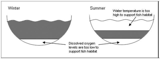
Temperate impoundments commonly exhibit a vertical stratification of the water column, wherein the surface water layer is heated by solar radiation and aerated by wind-action and photosynthesis, while the bottom layer of water remains cold and anoxic (Figure 1). This can result in a trout 'habitat squeeze' in temperate-stratified impoundments where the surface waters are too warm, and the DO concentrations in the deep waters are too low (Coutant 1985; Coutant 1986).
A study in Lake Eildon (Douglas 2008; Douglas et al. 2009), indicated that the volume and extent of trout habitat in impoundments can be modelled for applying trout temperature and dissolved oxygen tolerances to the hydrology and bathymetry of the impoundment. This study indicated that the extent and volume of trout habitat can be considerably reduced in summer and restricted to the deeper section of the impoundment:
- limiting the area where the trout can forage
- increasing competition for food and space
- forcing the fish into areas that are suboptimal
Such conditions could have adverse implications on the fishery by impacting on growth, reproductive capacity, overall fish condition and fishery performance (Zale et al. 1990; Headrick and Carline 1993; Douglas et al. 2009).
Fishery assessments of Lake Hume in 2005 indicated that despite stocking of the impoundment with brown and rainbow trout, the relative abundance and the condition of these fish caught in surveys was low (Douglas 2010). While the Lake Hume trout fishery can produce quality fish at times, it is generally acknowledged to be inconsistent as there appears to be large annual variation in the performance of the fishery (Personal Communication: Russell Mason, experienced Lake Hume fisherman and owner of Compleat Angler store Lavington). Lake Dartmouth by comparison has a trout fishery with less annual and seasonal variation and which consistently produces quality fish (Douglas et al. 2002).
Water level, depth morphometry, draw-down operation and temperature may all interact to dictate the amount of summer trout habitat in impoundments. Lake Hume is relatively wide and shallow so it is possible that the reduction in summer trout habitat is more frequent and severe compared to Lake Dartmouth which is steeper and deeper. The differences in the amount of summer trout habitat may be a principal factor that influences the performance of these impoundment trout fisheries.
Objectives
The project aimed to use GIS modelling to specifically:
- Determine the volume of summer trout habitat and compare the extent of seasonal habitat squeeze between Lake Hume and Lake Dartmouth.
- Provide recreational anglers with information on the most likely location of trout in the summer months.
- Create a tool to assist fisheries managers plan stocking rates based on predicted summer trout habitat.
Figure 1. Conceptual model showing impoundment stratification (in cross section) during winter (low air temperature) and summer (high air temperature), indicating a habitat squeeze.
Shaded sections indicate suitable fish habitat; unshaded sections indicate unsuitable fish habitat where the water temperature was too high and/or dissolved oxygen concentrations were too low.
Methods
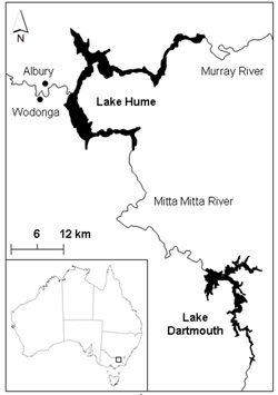
Figure 2. Lake Hume and Lake Dartmouth systems in northeastern Victoria.
Study systems
Lake Hume and Lake Dartmouth are two of the largest freshwater impoundments in south-eastern Australia (Figure 2, 36o05'55"S 147o01'54"E, 36o33'25"S 147o31'22"E). Both impoundments are monomictic, meaning they stratify and mix only once per year (Walker and Likens 1975).
LAKE HUME
Lake Hume was built in 1934 and is the major operating storage of the River Murray system. The storage regulates the River Murray, and re-regulates water discharged from the Snowy Mountains Hydro-electric Scheme (Goulburn-Murray Water 2010). Releases from Lake Hume supply irrigation, domestic and stock use and urban demands. Lake Hume follows an annual cycle of filling and drawdown (Figure 3). The storage usually receives inflows from the Murray and Mitta Mitta Rivers during winter and fills by the end of spring each year. Previous research has shown that inflows from the Murray and Mitta Mitta Rivers are typically colder (1-2 and 2-4 oC respectively) and denser than the surface layer of Lake Hume and consequently may underflow the main water (Brymner 1985; Sherman 2005; Baldwin et al. 2008). Water releases generally occur between December and May, with Lake Hume regularly drawn down to less than half of its capacity by the end of autumn. Lake Hume holds over three million megalitres of water at full capacity and has a large surface area to volume ratio indicating it is relatively shallow compared with other large impoundments (Table 1). Previous studies have shown that Lake Hume stratifies annually from October or November and destratifies some time between late March and mid-April (Walker and Hillman 1977; Brymner 1985; Baldwin et al. 2008).
Lake Hume has been regularly stocked with brown and/or rainbow trout since 1961 (Barnham 1989) and stocking continues annually (Table 2). While the Lake Hume trout fishery can produce quality fish at times, it is generally acknowledged to be inconsistent (Douglas 2010), as there appears to be large annual variation in the performance of the fishery (Personal Communication: Russell Mason, experienced Lake Hume fisherman and owner of Compleat Angler store Lavington)
LAKE DARTMOUTH
Lake Dartmouth was built in 1979 and provides carry-over storage for irrigation, domestic and stock use. In dry seasons, the storage supplements releases from Lake Hume and increases supplies to the River Murray system (Goulburn-Murray Water 2010). The impoundment receives inflows from three main rivers - the Mitta Mitta, Gibbo and Dart - as well as several smaller tributaries (Figure 2). Lake Dartmouth does not follow an annual cycle of filling and drawdown but rather remains constant for extended periods of time (Figure 3). Lake Dartmouth holds close to four million megalitres at full capacity and has a small surface area to volume ratio, indicating it is relatively deep compared with other large impoundments (Table 1).
Lake Dartmouth was stocked between 1979 and 1981 with a total of 50,000 rainbow trout (Barnham 1989; Hume 1991). Lake Dartmouth is currently not stocked as it is regarded as having a self-sustaining trout population that produces a consistent fishery (Douglas ;et al. 2002).
Table 1. Specifications of Lake Hume and Lake Dartmouth (Bureau of Meterology 2010; Goulburn-Murray Water 2010)
| Lake | Dartmouth | Hume |
|---|---|---|
| Year constructed completed | 1979 | 1934 |
| Capacity volume (ML) | 3,907,590 | 3,036,500 |
| Area submerged (ha) at capacity volume | 6,380 | 20,019 |
| Surface area to volume ratio at capacity volume ((ha*100)/ML) | 0.16 | 0.66 |
| Elevation at capacity volume (m AHD) | 486 | 192 |
| Mean annual maximum and minimum air temperature (oC) | 20.5-7.5 | 21.5-9.9 |
Table 2. Brown and rainbow trout stocking history for Lake Hume since 2000
| Year | Number of brown trout | Number of rainbow trout |
|---|---|---|
| 2000 | 30,000 | |
| 2001 | ||
| 2002 | ||
| 2003 | 10,000 | |
| 2004 | 50,000 | |
| 2005 | 50,000 | |
| 2006 | 50,000 | 10,100 |
| 2007 | 10,000 | |
| 2008 | 53,460 | 10,000 |
| 2009 | 21,570 | 28,230 |
| 2010 | 50,000 | 10,000 |
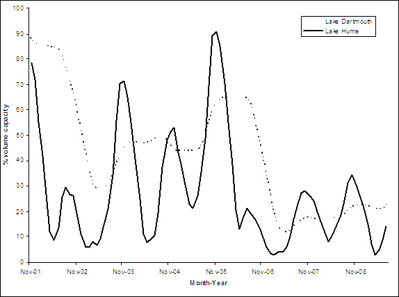
Figure 3. Changes in mean monthly volume (ML) at Lake Hume and Lake Dartmouth from 1982 until 2009.
Sampling and data source
Trout (brown and rainbow) habitat in Lake Hume and Lake Dartmouth was considered to be water that was within both the thermal and dissolved oxygen levels preferred by these species. A water temperature preference of 19 oC was chosen as a maximum. While trout survive water temperatures into the mid-twenties oC for short periods, 19 oC is considered to be the limit to preferred habitat because it is the temperature at which:
- feeding ceases for brown trout
- the upper end of optimal growth conditions for rainbow trout
- catch rates for brown and rainbow trout are considered 'unsatisfactory' to anglers (McMichael and Kaya 1991; Elliott and Hurley 2000).
A dissolved oxygen (DO) concentration of 3 ppm was chosen as a minimum limit because it is the incipient lethal limit for trout (Raleigh et al. 1984). Based on these preferences, suitable trout habitat strata was considered to be the water column bounded between the top edge of the hypolimnion (where DO concentration dropped below 3 ppm) and the 19 oC isotherm. These parameters were consistent with those used in the Lake Eildon brown trout habitat model which was validated by Douglas et al. (2009).
The water level and depth profile data of temperature and dissolved oxygen for Lake Dartmouth and Lake Hume were automatically recorded by thermistor chains and supplied by Goulburn-Murray Water and NSW Statewater respectively. The thermistor chain in Lake Dartmouth is located near the dam wall. Two thermistor chains were located in Lake Hume, one near the dam wall and one in the Mitta Mitta Arm. It was assumed that data recorded by thermistor chains were representative of the entire impoundments. Depth profile data recorded by thermistor chains were reviewed to determine the months of impoundment stratification and the mean monthly depths of the top edge of the hypolimnion and the 19 oC isotherm. Where more than one depth profile was recorded during the month, the mean depth for each parameter was recorded.
DO profiles were only available for Lake Hume between February 2002 and May 2004. Considering this time period encompassed a variety of water levels, weather conditions and wind speeds which influence water mixing, it was assumed the hypolimnion depth during this time period was representative of all the Lake Hume depth profile data. There was no seasonal trend in the depth of the hypolimnion derived from the DO profiles during this time period; consequently, the average hypolimnion depth of 6.2 m was applied to all Lake Hume depth profile data.
Using GIS (ArcGIS 9.3; ESRI, Redlands, California, USA), the habitat strata parameters were applied to the known impoundment bathymetry and water level to delineate the mean monthly volume of trout habitat for the whole of both impoundments. Units of habitat were expressed as volume because fish habitat is three dimensional, and volume has been shown to be a better predictor of brown trout territory than area (Ayllónet al. 2010).
The GIS method was applied to data from Lake Dartmouth between December 1982 and March 2010, and Lake Hume between November 2001 and August 2009. Months when impoundments were stratified (from November until April) were defined as summer and months when impoundments were not stratified (from May until October) were defined as winter. Mean monthly maximum and minimum air temperatures and mean rainfall at both impoundments were obtained from the Bureau of Meteorology website (2010).
Analyses
OBJECTIVE 1. SUMMER TROUT HABITAT
To determine the volume of summer trout habitat in Lake Hume and Lake Dartmouth between 2001 and 2009, the mean volume of habitat and standard error was calculated and presented in a time series plot. The mean annual summer trout habitat volume of the impoundments was compared with one-tailed t-tests and time series plots.
The extent of seasonal habitat squeeze between Lake Hume and Lake Dartmouth was compared with one-tailed t-tests and presented in time series plots by:
- mean surface area to volume ratio (as a measure of depth morphometry)
- the percentage habitat volume reduction between winter and the following summer.
Habitat volume percentage reductions were standardised for differing water levels between impoundments by comparing the trout habitat volume available as a percentage of the water volume present in each impoundment at that time.
OBJECTIVE 2. INFORMATION FOR ANGLERS
To provide recreational anglers with information on the most likely location of trout in the summer months, the monthly trout habitat depth strata for each impoundment was assessed and summarised.
OBJECTIVE 3. A TOOL FOR FISHERIES AND WATER MANAGERS
To create a tool that can be used to assist fisheries managers plan stocking rates based on predicted summer trout habitat, past water levels, mean monthly maximum and minimum air temperatures, and mean rainfall were plotted against GIS predicted trout habitat volume for each month. The relationship between the trout habitat volume and water level in each impoundment was analysed using linear regression models for summer and winter periods.
Results
Summer trout habitat
Between 2001 and 2009, the extent of summer trout habitat in Lake Hume and Lake Dartmouth was estimated to average 21,114 ± 13,401 ML (mean ± SE) and 871,828 ± 209,148 ML respectively. The estimated volumes of summer trout habitat represent 0.70 ± 0.45% of Lake Hume and 22.27 ± 5.34% of Lake Dartmouth at total maximum capacity. The mean volume of summer trout habitat was significantly lower in Lake Hume compared with that in Lake Dartmouth (t = 2.36, d.f. = 7, P = 0.0024; Figure 4).
The low water levels and hot dry summers of 2002/03 and 2006/07 (Bureau of Meterology 2010) are shown as low volumes of summer trout habitat in Lake Dartmouth (Figure 4).
Despite fluctuating water levels, Lake Hume remained significantly shallower than Lake Dartmouth throughout the period of the study (t= 1.99, d.f. = 69, P < 0.001). The mean surface area to volume ratio from 2001 to 2009 was 1.6 x 10⁻² ± 4.2 x 10⁻⁵ ha/ML (mean ± SE) in Lake Hume and 2.6 x 10⁻³ ± 3.7 x 10⁻⁷ in Lake Dartmouth.
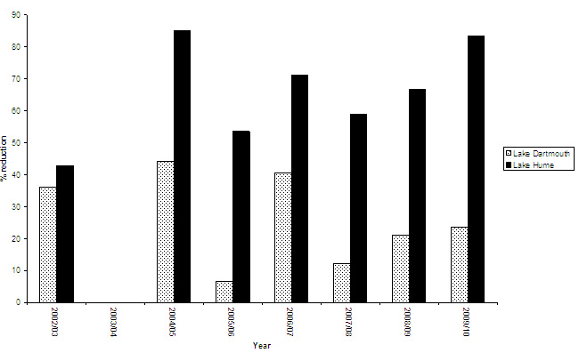
The mean percentage habitat volume reduction between winter and the following summer was significantly greater in the shallower impoundment of Lake Hume compared with the deeper impoundment of Lake Dartmouth (t = 2.18, d.f. = 12, P = 0.0002; Figure 5). Between winter 2002 and summer 2009/10, Lake Hume was found to have a mean percentage habitat volume reduction of 65.91 ± 5.84% (mean ± SE) and Lake Dartmouth was found to have a reduction of 26.24 ± 5.43%.
Figure 4. Changes in mean volume of summer trout habitat (ML) at Lake Hume and Lake Dartmouth in months of November until April from 2001/02 and 2008/09. Error bars represent ± SE.
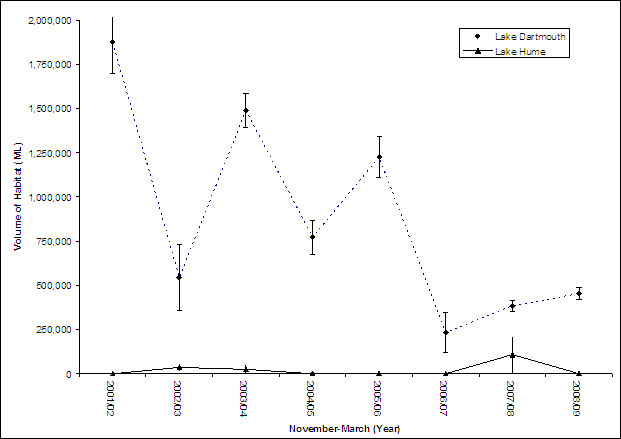
Figure 5. Changes in mean percentage trout habitat volume reduction between winter and the following summer at Lake Hume and Lake Dartmouth from winter 2002 and summer 2009/10.
X-axis marks the date of the summer, marking the change from the previous winter.
Information for anglers
For Lake Hume, the assessment of the monthly trout habitat depth strata indicated there is minimal suitable trout habitat available during summer months. Data from 4 of the 8 summers indicated that there was zero suitable trout habitat. Suitable trout habitat was found during April for 3 summers at average depths of between 3 and 6 metres (Table 3).
While the depth profile data did not detect any cold inflows from the Murray or Mitta Mitta Rivers (due to placement of the thermistors), summer inflows from the Mitta Mitta River have been reported to be within trout tolerances (17-19 oC) and > 3 ppm DO. These cold inflows from the Mitta Mitta River are reported to intrude into the main basin of the storage at a depth of between 13 and 17 m but were detected as shallow as 4 m (Brymner 1985; Sherman 2005; Baldwin et al. 2008). Based on this evidence, the most likely location of trout in Lake Hume during the summer months between November and March is close to the river inflows, particularly the Mitta Mitta River and at depths greater than 4 metres. During winter months. suitable trout habitat exists between the surface and six metres deep. Depths below six metres were expected to be too anoxic to support trout habitat.
For Lake Dartmouth, the assessment of the monthly trout habitat depth strata indicated trout habitat during summer months was located on average between 9 and 47 metres deep. During winter months, trout habitat was located between the surface and 43 metres deep. The most likely location of trout in Lake Dartmouth during summer and winter is the water column bounded by these depths (Table 3).
Table 3. Average suitable trout habitat depths (m) for summer (shaded) and winter months (unshaded) in Lake Hume and Lake Dartmouth between 2001 and 2010.
| Lake Hume | Lake Dartmouth | ||||
|---|---|---|---|---|---|
| Month | Min depth (m) | Max depth (m) | Month | Min depth (m) | Max depth (m) |
| November | At depths greater than 4 metres near river inflows (particularly the Mitta Mitta) | November | 4 | 48 | |
| December | December | 9 | 52 | ||
| January | January | 12 | 52 | ||
| February | February | 12 | 46 | ||
| March | March | 14 | 45 | ||
| April | 3 | 6 | April | 3 | 41 |
| May | 0 | 6 | May | 0 | 41 |
| June | 0 | 6 | June | 0 | 41 |
| July | 0 | 6 | July | 0 | 43 |
| August | 0 | 6 | August | 0 | 46 |
| September | 0 | 6 | September | 0 | 42 |
| October | 0 | 6 | October | 0 | 44 |
A tool for fisheries and water managers
Trout habitat models were created based on predicted water levels for winter in both Lake Hume and Lake Dartmouth. For both impoundments, winter trout habitat was modelled using multiple linear regression models. GIS predicted habitat and water level (supplied by Goulburn-Murray Water) are both expressed as a percentage of total impoundment capacity.
The relationship between winter trout habitat and water level in Lake Hume was curvilinear and the quadratic term for water level was included in the regression model. The relationship was given by the model equation:
Habitat% = 1.25 + 0.66 x (Water Level%) - 0.0032 x (Water Level%)2 (1)
The resulting P-values for coefficients of Water Level and the quadratic term of Water Level are both significant (P < 0.001). This model explained 98.2% of the total variation in the winter habitat values (Figure 6).
The relationship between winter trout habitat and water level in Lake Dartmouth was linear and given by the model equation:
Habitat% = -0.37 + 0.65 x (Water Level%) (2)
Water Level had a very strong positive effect (P < 0.001). This model explained 87.7% of the total variation in the winter trout habitat values (Figure 7).
For both Lake Hume and Lake Dartmouth, the effect of average monthly rainfall on winter trout habitat was not statistically significant. This is likely due to strong positive correlations between water levels and the average monthly rainfall.
No statistically significant effect was found between average monthly maximum and minimum air temperatures on winter trout habitat on either Lake Hume or Lake Dartmouth. This may be due to the fact that the winter temperatures are mild (average maximum temperatures of 16.6 oC for Hume and 15.1 oC for Dartmouth) and they do not cause significant water surface heating.
Trout habitat models were based on predicted water levels for summer in Lake Dartmouth only as Lake Hume had virtually no habitat in summer between 2001 and 2009. The effect of heating on summer trout habitat in Lake Hume was so pronounced that 84% of the summer months had no suitable trout habitat at all and the remaining 16% had very little habitat.
In Lake Dartmouth, as nearly all summer months had positive habitat values multiple linear regression models were fitted with water level and average maximum Lake Dartmouth air temperature as predictor variables (Figure 8). GIS predicted habitat and water level (supplied by Goulburn-Murray Water) are both expressed as a percentage of total impoundment capacity. The relationship was given by the model equation:
Habitat% = 14.80 + 0.59 x (Water Level%) - 0.76 x (Mean Monthly Max Air Temp) (3)
This model explained 81% of the variation in the summer trout habitat values and as expected, the water level had a significant positive effect on the volume of summer trout habitat (P < 0.001) and the average monthly maximum air temperature had a significant negative effect on the volume of summer trout habitat (P < 0.001). Again, the effect of average monthly rainfall on summer trout habitat was not statistically significant and this was likely due to a strong positive correlation with water level.
Figure 6.
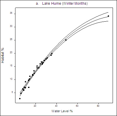
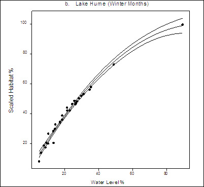
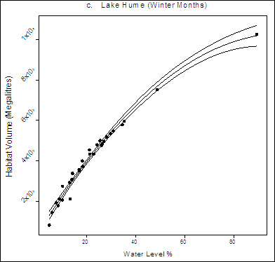
Figure 6. Relationship between winter habitat and water level (provided by Goulburn-Murray Water) with 95% confidence limits for Lake Hume (R2 = 0.982, Habitat% = 1.25 + 0.66 x (Water Level%) - 0.0032 x (Water Level%)2.
Habitat on Y-axis is expressed in different scales in each of these graphs: a) percentage with respect to total capacity, b) scaled percentage of the maximum observed percentage of habitat being 100% and c) volume in megalitres.
Figure 7.
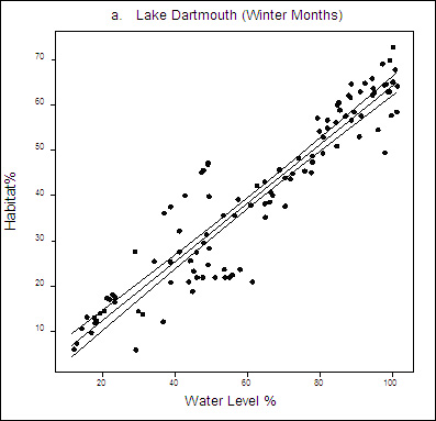
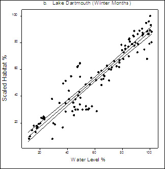
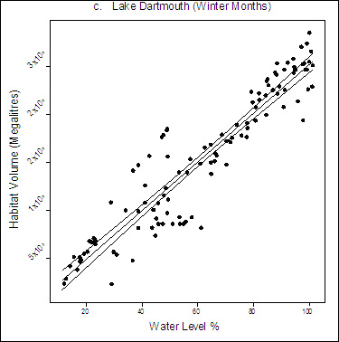
Figure 7. Relationship between winter habitat and water level (provided by Goulburn-Murray Water) with 95% confidence limits for Lake Dartmouth (R2 = 0.877, Habitat% = -0.37 + 0.65 x (Water Level%)).
Habitat on Y-axis is expressed in different scales in each of these graphs: a) percentage with respect to total capacity, b) scaled percentage of the maximum observed percentage of habitat being 100% and c) volume in megalitres.
Figure 8.
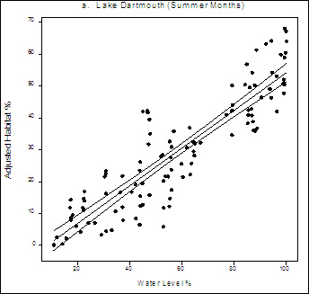
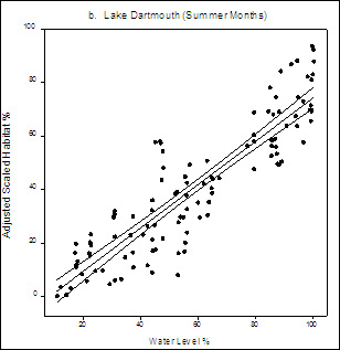
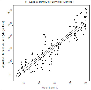
Figure 8. Relationship between adjusted summer trout habitat and water level (provided by Goulburn-Murray Water) with 95% confidence limits for Lake Dartmouth (R2 =0.81, Habitat% = 14.80 + 0.59 x (Water Level%) - 0.76 x (Mean Monthly Max Air Temp)).
Habitat on Y-axis is expressed in different scales in each of these graphs: a) percentage with respect to total capacity, b) scaled percentage of the maximum observed percentage of habitat being 100% and c) volume in megalitres.
Discussion
GIS modelling was used successfully to satisfy all three of the project objectives.
Summer trout habitat
This study determined and compared the volume of summer trout habitat and the extent of trout habitat squeeze in both Lake Hume and Lake Dartmouth.
Between 2001 and 2009 the mean volume of summer trout habitat in Lake Hume (~21,000 ML) was 41 times lower than that in Lake Dartmouth (~872,000 ML). Lake Hume had approximately a 66% reduction in habitat volume between winter and the following summer, compared with 26% in Lake Dartmouth.
Douglas et al. (2009) reported an 82% reduction in surface area of brown trout habitat in Lake Eildon over one year. These two studies indicate that substantial reductions in trout habitat volume and extent occur in the three Victorian impoundments studied to date. The impact of trout habitat reduction in summer should be considered for all Victoria's impoundments.
The significant differences in habitat volume and extent of habitat squeeze between Lake Hume and Lake Dartmouth can be primarily attributed to differences in the depth morphometry, but may also relate to differences in draw-down operation and air-temperature.
Lake Hume was found to be consistently shallower than Lake Dartmouth throughout the period of the study. Because shallow impoundments require less heat to stratify (Gorham 1964) and stratify earlier than deeper impoundments (Nurnberg 1988; Demers and Kalff 1993), the depth morphometry of the impoundments is a reasonable explanation for differences in habitat volume.
Different draw-down operations between Lake Hume and Lake Dartmouth may also explain differences in habitat volume. Lake Dartmouth has relatively consistent water levels between winter and the following summer. Lake Hume has a consistent drawn-down period throughout each summer. This feature of Lake Hume is likely to have contributed to the impoundment's habitat volume reduction (habitat squeeze).
The air-temperature of the impoundments is possibly a third contributing factor to the difference in habitat volume between the Lake Hume and Lake Dartmouth. Temperature encompasses the location differences between the impoundments including altitude, latitude and longitude (Kalff 1991). Lake Hume has higher mean annual maximum and minimum air temperatures compared to Lake Dartmouth. This factor contributes to water temperatures rising beyond levels most suitable for trout in Lake Hume. If the assumptions regarding the cause of habitat squeeze are correct, then depth morphometry, draw-down operation and air-temperature should be considered when estimating trout habitat in all impoundments.
Without a comparable time series of data on fishery performance, direct evaluation of the relationship between trout habitat and fishery performance cannot be made. Indirectly the association between fishery performance and available trout habitat can be drawn using the trout fishery or fish population performance reported from Lake Hume and Lake Dartmouth. These data are consistent with the relationship described in this report.
The only formal fishery assessment of Lake Hume was conducted in 2005. The assessment indicated that despite stocking of the impoundment with trout, the relative abundance of both stocked and wild trout caught in netting and creel surveys was low. The average condition of these fish was 'poor to fair' (Barnham and Baxter 1998; Douglas 2010). Anglers were estimated to catch an average of between 0.002 and 0.013 brown trout per hour.
A trial stocking of 50,000 fingerling brown trout (50-99 g) in September and October of 2004 was estimated to have contributed an extra 75 fish to anglers, equating to a 0.15% return from stocking (Douglas 2010).
In Lake Hume, our study estimated the volume of trout habitat reduced from 204,459 to 0 ML between winter of 2004 and summer of 2004/05, and then from 661,443 to 0 ML between the winter 2005 and summer of 2005/06.
In contrast, Lake Dartmouth is no longer stocked with trout and is considered to produce a more consistent fishery than Lake Hume as there is little annual variation in angler catch and condition of catch between seasons (Douglas et al. 2002). Hume (1991) conducted two years of creel surveys on Lake Dartmouth during 1984/85 and 1985/86 and estimated that anglers harvested an average of between 0.42 ± 0.05 and 0.28 ± 0.01 trout per hour respectively.
Between 1984 and 1986, our study estimated the volume of trout habitat in Lake Dartmouth reduced by 21% (1,154,372 to 1,006,096 ML) between winter of 1984 and summer of 1984/85, and then by 25% (1,532,923 to 1,135,444 ML) between the winter 1985 and summer of 1985/86.
Between 1999 and 2000 Douglas et al. (2002) estimated anglers caught an average of 0.27 trout per hour and concluded that the Lake Dartmouth brown trout population was 'self-sustaining' and remained a premier trout angling water.
In Lake Dartmouth our study estimated the volume of trout habitat reduced by 25% (842,359 to 605,198 ML) between winter of 1999 and summer of 1999/2000.
These predictions of trout habitat are consistent with these fishery assessment results and appear to be one explanation for the differences among impoundments in trout fishery/population performance. By conducting regular fisheries assessments to assess the abundance and condition of trout in both impoundments over time, predictions of trout habitat can be validated and more confidence can be placed in the use of them for managing impoundment fisheries.
Our findings demonstrate that suitable trout habitat in Lake Hume is predominantly limited to winter months. The trout fishery is enhanced with annual stocking but re-assessment of the timing of stocking and considerations of size of fish stocked, species suitability and numbers of fish stocked (stocking density) may improve the performance of the fishery.
Stocking trout at the start of winter (April-June), to coincide with increasing amounts of suitable trout habitat, could maximise the volume of water that trout can both feed and grow in, as well as be caught in by anglers. There may be alternative species or strains of fish that are more suited to the conditions of Lake Hume. For example, rainbow trout may be more suitable to stock into Lake Hume because they are generally a faster growing fish than brown trout in most circumstances (Hill 2007). Rainbow trout may reach a larger size and be available to be exploited by anglers earlier than brown trout, which could reduce the impact of habitat restrictions on the fishery. Rainbow trout may also be advantageous because in some Australian waters they appear to be more catchable than brown trout (Faragher and Gordon 1992; Douglas and Hall 2004; Brown and Gason 2007).
An increase in the size of trout that are stocked may allow larger fish to be exploited by anglers earlier than smaller fish and reduce the impact of habitat restrictions on the fishery. Larger fish are generally more expensive to produce than smaller fish and consideration would need to be given to whether any improvements in fishery performance adequately offset the costs associated with the production of larger fish.
Native fish like golden perch (Macquaria ambigua) and Murray cod Maccullochella peelii) prefer warmer water-temperatures than trout (Cadwallader 1983; Lintermans 2007) and are currently stocked to develop and maintain a fishery in Lake Hume (Douglas 2010). These species usually provide a fishery that is variable and seasonal (summer), without a substantial winter output.
A reduction in trout stocking density in Lake Hume as suggested by Douglas (2010), may reduce competition for habitat resources between trout, therefore improving growth rates and fishery performance. A reduction in stocking densities may only be required in some years as the Lake Hume trout population displays high variability most likely in response to the limitations of summer trout habitat.
The model outputs of future estimated summer trout habitat volumes can inform decisions on appropriate stocking densities for that year. This can improve the cost effectiveness of stocking strategies.
Information for anglers
This study has provided recreational anglers with information on the most likely location of trout in the summer months of both Lake Hume and Lake Dartmouth.
For Lake Dartmouth, anglers were provided with a table explaining the depths where suitable trout habitat exists. Similar research on rainbow trout by Jones (1982) provided anglers with information to help them target the more suitable areas and depths of a Kentucky impoundment in the USA.
For Lake Hume, the results are less simple as we predicted there to be minimal suitable habitat during summer. Anglers wanting to target trout in Lake Hume during summer are advised that trout would most likely be located close to the river inflows, particularly the Mitta Mitta River and at depths generally greater than 4 metres. While trout may survive in water with temperatures exceeding 19 oC, the evidence suggests they are unlikely to feed at these temperatures and consequently have low catchability to anglers (McMichael and Kaya 1991; Elliott and Hurley 2000).
A tool for fisheries and water managers
Models were successfully created that can be used to assist fisheries managers plan stocking rates based on predicted summer trout habitat. Our analysis encompassed the effects water management regimes and considered the effects of temperature and rainfall. The winter trout habitat models for Lake Hume and Lake Dartmouth indicate that water levels explained a very high percentage of variation in habitat volume (98.2 and 87.7% respectively). The summer trout habitat model for Lake Dartmouth explained 81% of the variation in habitat volume including the significant negative effect of maximum air temperature.
The relationships of the Lake Dartmouth models were linear, whereas the relationship of the Lake Hume model was curvilinear, because any increases in the water level of Lake Hume will spread water over a greater surface area than in Lake Dartmouth.
Rainfall was not a significant predictor in any model because rainfall and water level are highly correlated and draw-down operation probably overrides any potential affect rainfall may have on water levels and thus trout habitat. Importantly, the trout preference parameters applied here have been validated by Douglas et al. (2009); therefore the models presented in this study can be used by fisheries and water managers to accurately predict the volume of trout habitat in impoundments.
The tool created to assist fisheries managers plan stocking rates based on predicted summer trout habitat is derived from the models presented in this study. The 'TroutHab' excel program file is designed to predict the amount of suitable trout habitat in terms of:
- water volume
- percentage volume of total capacity
- scaled percentage of the maximum observed percentage of habitat being 100% based on water level of the impoundment.
Providing accurate predictions of water level can be obtained (from water managers), the amount of suitable trout habitat can be predicted up to six months in advance for either summer or winter in Lake Hume or Lake Dartmouth.
TroutHab will be most useful at the beginning of summer (November-December) when trout are ready to be stocked into impoundments. Managers can use TroutHab to estimate the amount of suitable habitat available for trout upon stocking, and the amount of suitable habitat available at the predicted draw-down level of the impoundment. By considering the predictions of suitable trout habitat, modification to stocking decisions may include the numbers of trout to be stocked, the species of trout to be stocked and the timing of stocking in impoundments.
TroutHab will be of use to fisheries and water managers to assist in optimising the effectiveness of fish stocking, minimising potential overstocking and explaining the reasoning to recreational anglers behind stocking decisions. The amount of suitable habitat should be considered when fishery managers determine stocking densities or the suitability of impoundments for particular fish species. Stocking large numbers of fish into a relatively small amount of habitat could cause density dependent limitations on growth and higher mortality such that the fishery may not be productive in the long term (Coutant 1985; Coutant 1986; Rowe and Chisnall 1995).
Other applications
Fish habitat models such as those described in this study can be easily modified for alternative species or life-stages of fish, or for predicting the likelihood of fish kills and the effects of climate change. While these models were developed for trout and applied to two impoundments of south-eastern Australia, they could be applied to any species in any impoundment where the thermal and oxygen preferences can be ascertained and the impoundment bathymetry can be obtained (Douglas et al. 2009).
Rowe et al. (2002) used GIS modelling to effectively predict the spawning area of the main prey species for trout (smelt Retropinna retropinna) based on water levels in the rainbow trout fishery of Lake Taupo, New Zealand. Douglas and Abery (2008) used GIS modelling and the acoustic tracking of golden perch (Macquaria ambigua) and brown trout in Lake Eildon to demonstrate habitat partitioning between the species.
By substituting thermal and oxygen preferences in the model to suit different life stages of fish, a greater understanding of habitat restrictions in impoundments can be gained. For example, Coutant (1986) developed habitat models for different life stages of striped bass to effectively explain reductions in bass populations. A reduction in habitat may make some species more vulnerable to overfishing. Knowledge of the extent of suitable habitat may allow managers to apply fishing restrictions in critical areas at critical times. Alternatively, trout temperature tolerances could be substituted for the lethal limit parameters for trout in order to predict fish kills.
Finally, research into the stratification of impoundments has been used to estimate the effect of climate change with respect to the onset of algal blooms (Demers and Kalff 1993). This project demonstrates that fish habitat modelling may be useful for developing long-term management strategies for impoundment fisheries in response to predicted future climate-change impacts (Chang et al. 1992; Stefan et al. 2001; Fang et al. 2004; Douglas et al. 2009; Gerdeaux 2010).
Conclusions
This study found:
- The mean volume of summer trout habitat in Lake Hume was significantly lower at approximately 21,000 ML compared with approximately 872,000 ML in Lake Dartmouth between 2001 and 2009.
- Lake Hume experiences a greater habitat squeeze and is less suitable for trout than Lake Dartmouth because it has shallower morphometry, a consistent summer draw down and higher air temperature.
- Suitable trout habitat in Lake Hume is predominantly limited to winter months. Re-assessment of the timing of stocking and considerations of species suitability and numbers of fish stocked (stocking density) may improve the performance of the fishery.
- In Lake Hume, recreational anglers would most likely find trout close to the river inflows, particularly the Mitta Mitta River and at depths generally greater than 4 metres during summer, and in the upper 6 metres of water during winter.
- In Lake Dartmouth, recreational anglers would most likely find trout between depths of 9 and 47 metres during summer and between the surface and 43 metres during winter.
- A tool was created that can be used to assist fisheries managers plan stocking rates based on predicted summer trout habitat water levels. The model relationships presented in this report are the basis of the TroutHab excel program file.
Acknowledgements
The authors are grateful to:
- John Douglas for establishing the project
- Spatial Vision Inc. in particular Milos Pelikan, Lucy Minato and Luong Tran, Mina Jahanshahi for conducting the GIS modelling
- Goulburn-Murray Water, NSW Statewater, Peter Liepkalns and Brad Sherman for providing the data
- Fiona Gavine, Joy Sloan, Daniel Steel and Cameron McGregor for technical assistance
- Leanne Gunthorpe, James Andrews, Jon Presser, Joy Sloan and Kylie Hall for their helpful comments on the report.
This study was funded by the Victorian State Government from the Recreational Fishing Licence Trust Account.
References
Ayllón, D., Almodóvar, A., Nicola, G. G. and Elvira, B. (2010). Modelling brown trout spatial requirements through physical habitat simulations.River Research & Applications
26, 1090-1102.
Baldwin, D. S., Gigney, H., Wilson, J. S., Watson, G. F. and Boulding, A. N. (2008). Drivers of water quality in a large water storage reservoir during a perido of extreme drawdown. Water Research 42, 4711-4724.
Barnham, C. (1989). 'Fisheries Information report No. 2: Summary of immediately available records of non-indigenous and indigenous fish stockings in Victorian public waters 1871-1988.' Freshwater Fish Management Branch, Fisheries Division, Victoria.
Barnham, C. and Baxter, A. (1998). 'Condition Factor, K, for Salmonid Fish.' Fisheries Notes. State of Victoria, Department of Economic Development, Jobs, Transport and
Resources
(former) Department of Primary Industries.
Brown, P. and Gason, A. (2007). 'Goulburn River Trout Fishery: Estimates of Catch, Effort, Angler]satisfaction and Expenditure. .' Fisheries Victoria Research Report Series No. 30. Department of Economic Development, Jobs, Transport and
Resources
(former) Department of Primary Industries, Melbourne, Victoria.
Brymner, M. H. (1985). 'Thermal and chemical stratification in Lake Hume, July 1982 to June 1985.' Albury-Wodonga Development Corporation, Albury.
Bureau of Meterology (2010) Climate data online. In 'http://www.bom.gov.au/climate/data/'. (Government of Australia)
Cadwallader, P. L. (1983). 'A review of fish stocking in the larger reservoirs of Australia and New Zealand.' Food and Agriculture Organization of the United Nations, FAO Fisheries Circular No. 757, Rome.
Chang, L. H., Railsback, S. F. and Brown, R. T. (1992). Use of a reservoir water quality model to simulate global climate change effects on fish habitat. Climatic Change 20, 277-296.
Coutant, C. C. (1985). Striped bass, temperature, and dissolved oxygen: A speculative hypothesis for environmental risk Transactions of the American Fisheries Society 114, 31-61.
Coutant, C. C. (1986) Thermal niches of Striped Bass. In 'Scientific American'. pp. 98-104.
Demers, E. and Kalff, J. (1993). A simple model for predictign the date of spring stratification in temperate and subtropical lakes. Limnology and Oceanography 38, 1077-1081.
Department of Primary Industries (2007). 'North East Fishery Management Plan. .' Fisheries Victoria Management Report Series No. 48.
Douglas, J. (2008). 'Biology and movement of large brown trout in Lake Eildon.' Fisheries Revenue Allocation Committee Final Report. (former) DPI, Victoria.
Douglas, J. (2010). 'Lake Hume Fishery Assessment.' Recreational Fishing Grant Program - Research Report. Department of Primary Industries Victoria, Queenscliff.
Douglas, J. and Abery, N. (2008). Radio and acoustic telemetry validates models of seasonal habitat distribution for a two storied fishery. . Presentation at the International Symposium on Advances in Tagging and Marking Technology for Fisheries Management and Research, Auckland Feb. 24-28, 2008. sponsored by New Zealand Marine Sciences Society, Australian Society for Fish Biology, and American Fisheries Society. Location: Auckland, New Zealand.
Douglas, J. and Hall, K. (2004). 'Lake Wendouree Fisheries Assessment.' Fisheries Victoria Research Report Series No 7. Department of Primary Industries, Melbourne, Victoria.
Douglas, J., Hunt, T., Abery, N. and Allen, M. (2009). Application of GIS modelling to quantify fish habitat in lakes. Lakes and Reservoirs: Research and management 14, 171-174.
Douglas, J. W., Giles, A. and Strongman, R. J. (2002). 'Lake Dartmouth Multi-species Fishery Assessment.' Marine and Freshwater Resources Institute Freshwater Fisheries Report No. 02/2. Marine and Freshwater Resources Institute, Snobs Creek.
Elliott, J. M. and Hurley, M. A. (2000). Daily energy intake and growth of piscivorous brown trout, Salmo trutta. Freshwater Biology 44, 237-245.
Fang, X.,Stefan, H. G., Eaton, J. G., McCormick, J. H. and Alam, S. R. (2004). Simulation of thermal/dissolved oxygen habitat for fishes in lakes under different climate scenarios Part 1. Coolwater fish in contiguous US.Ecological Modelling 172, 13-37.
Faragher, R. A. and Gordon, G. N. G. (1992). Comparative exploitation by recreational anglers of brown trout, Salrno trutta L., and rainbow trout, Oncorhynchus mykiss (Walbaum), in Lake Eucumbene, New South Wales. . Australian Journal of Marine and Freshwater Research 43, 835-845.
Gerdeaux, D. (2010). Does global warming threaten the dynamics of Artic charr in Lake Geneva?Hydrobiologia 660, 69-78.
Gorham, E. (1964). Morphometric control of annual heat budgets in temperate lakes. Limnology and Oceanography 9, 525-529.
Goulburn-Murray Water (2010) Water storages. In 'http://g-water.com.au/water-resources/storages'. (Goulburn-Murray Water)
Headrick, M. R. and Carline, R. F. (1993). Restricted summer habitat and growth of northern pike in two southern Ohio impoundments. Transactions of the American Fisheries Society Symposium 122, 228-236.
Hill, D. (2007). 'Freshwater Fish of Victoria: Rainbow Trout.' Fisheries Note Number: FN0038, Fisheries Victoria, Department of Primary Industries, Melbourne.
Hume, D. (1991). 'Report on three years of creel surveys: 1984 to 1987.' Technical report series no. 122. Arthur Rylah Institute for Environmental Research. Department of Conservation and Environment, Victoria.
Jones, A. R. (1982). The "Two-Story" rainbow trout fishery at Laurel River Lake, Kentucky. North American Journal of Fisheries Management 2, 132-137.
Kalff, J. (1991). The utility of latitude and other environmental factors as predictors of nutrients, biomass and production in lakes worldwide: problems and alternatives. Verhandlungen der Internationale Vereinigüng für Limnologie 24, 1235-1239.
Lintermans, M. (2007). 'Fishes of the Murray-Darling Basin: An introductory guide.' (Murray-Darling Basin Commission: Canberra)
McMichael, G. A. and Kaya, C. M. (1991). Relations among stream temperature, angling success rainbow trout and brown trout, and fisherman satisfaction. North American Journal of Fisheries Management 11, 190-199.
Nurnberg, G. K. (1988). A simple model for predicting the date of fall turnover in thermally stratfied lakes.Limnology and Oceanography 33, 1190-1195.
Raleigh, R. F.,Hickman, T., Solomon, R. C. and Nelson, P. C. (1984). 'Habitat suitability information, rainbow trout. FWS⁄ OBS-82 ⁄ 10.60.' U.S. Fish and Wildlife Service, Washington, D.C.
Rowe, D. K. and Chisnall, B. L. (1995). Effects of oxygen, temperature and light gradients on the vericla distribution of rainbow trout, Oncorhynchus mykiss, in two north island, New Zealand, lakes differing in trophic status. New Zealand Journal of Marine and Freshwater Research 29, 421-434.
Rowe, D. K., Shankar, U., James, M. and Waugh, B. (2002). Use of GIS to predict effects of water level on the spawning area for smelt, Retropinna retropinna, in Lake Taupo, New Zealand. Fisheries Management and Ecology 9, 205-216.
Sherman, B. (2005). 'Hume Reservoir Thermal Monitoring and Modelling - Final Report.' Report to State Water as agent for Murray Darling Basin Commission. CSIRO Land and Water Client Report.
Stefan, H. G., Fang, X. and Eaton, J. G. (2001). Simulated fish habitat changes in north american lake in response to projected climate warming. Transactions of the American Fisheries Society 130, 459-477.
Walker, K. F. and Hillman, T. J. (1977). 'Limnological survey of the river murray in relation to Albury-Wodonga, 1973-1976. Report by Gutteridge, Haskins and Davey, Melbourne.' Albury-Wodonga Development Corporation, Albury.
Walker, K. F. and Likens, G. E. (1975). Meromixis and a reconsidered typology of lake circulation patterns.Verhandlungen Internationale Vereiningung für Theoretische und Angewandte Limnologie 19, 442-458.
Zale, A. V., Wiechman, J. D., Lochmiller, R. L. and Burroughs, J. (1990). Limnological conditions associated with summer mortality of striped bass in Keystone Reservoir, Oklahoma. Transactions of the American Fisheries Society 119, 72-76.