Goulburn-Eildon Region Fisheries Management Plan
Foreword
The upper Goulburn region is well recognised as one of the most popular and important recreational fishing destinations in Victoria. With this in mind, the primary objective in managing the region's inland fisheries is to provide a wide variety of fishing experiences for recreational anglers, with year-round fishing opportunities, while ensuring the long-term sustainability of the resource. The Goulburn-Eildon Region Fisheries Management Plan establishes the framework to achieve that objective.
As part of the Bracks Government's commitment to effective community engagement in decision making, the Fisheries Co-Management Council in consultation with the Inland Fisheries Committee has overseen the preparation of the plan.
In addition, the active contribution of the Goulburn-Eildon Region Fisheries Management Plan Steering Committee has substantially shaped the plan's content by providing the focus for input from major stakeholder groups, anglers and other interested agencies in the upper Goulburn region. This extensive community input gives rise to my confidence that the plan will accommodate both the current and future needs of the fishery and its users.
The plan sets out the strategies and actions for managing the fishery over the next five years. In doing so, it acknowledges the need to establish and strengthen partnerships between all stakeholders sharing an interest in the management of the region's fish stocks and aquatic habitats and the waterways that support them. It is part of the Bracks Government's vision for Victoria as a state where protecting the environment and using our resources sustainably is built into everything we do.
In the years to come, it is expected that management issues will change as new information about the fishery comes to light. The evolution of different attitudes and traditions within the angling community may also give rise to the need for new management initiatives. Therefore, it is important that this plan is not regarded as a static document, but rather as a dynamic mechanism that will be adapted and enhanced according to changing community requirements and increased understanding of the environmental factors affecting the fishery.
To that end, the Government will continue to invite input from stakeholders in implementing and refining the plan in the years ahead.
I take this opportunity to congratulate all those involved in the plan's development, in particular the Goulburn-Eildon Region Fisheries Management Plan Steering Committee for its sustained commitment to this project.
Candy Broad
Minister for Energy and Resources
Steering Committee Members and Affiliations
| Chair: Mr Rod Theobald Landowner Nagambie | Mr Les Penrose VRFish Thomastown |
| Mr Murray Chapman GBCMA Yea | Mr J. Pincombe Guide Mansfield |
| Mr Neville Fowler DNRE Regional Services Benall | Councillor Mike Dalmau Murrindindi Shire Alexandr |
| Mr Wayne Fulton MAFRI (Snobs Creek) Alexandra | Mr Russell Wealands GBCMA Yea |
| Mr Mick Hall Eildon Action Eildon | Mr Graeme Wilkinson Goulburn-Murray Water Tatura |
| Mr John Kirkman (deceased) VRFish Ferntree Gully | Mr Ross Winstanley formerly DNRE (Fisheries Victoria) Geelong |
| Mr Gary O'Donaghue VRFish Glen Waverley |
How to use this document
The document is divided into four principal parts.
- Part 1 describes the legal and planning process of the GERFMP, and includes the context, the background and the overall goals and objectives of the document.
- Part 2 divides the area of the GERFMP into smaller management units. A narrative overview describes the area's geomorphology, water management, environmental issues, access and current fisheries, and lists the specific goals, objectives, proposed management and strategies for each section.
- Part 3 presents the actions, research priorities and performance indicators required to implement the GERFMP.
- Part 4 lists further reading and supporting information.
Abbreviations used through this document
| AWT | Australian Water Technologie |
| CoA | Commonwealth of Australia |
| CoM | Committee of Management |
| CMA | Catchment Management Authority |
| DNRE | Department of Natural Resources and Environment |
| EPA | Environment Protection Authority |
| ESD | Ecologically Sustainable Development |
| FCC | Fisheries Co-Management Council |
| F&F | Flora and Fauna |
| FEIS | Fisheries Economic Impact Studies |
| FFG | Flora and Fauna Guarantee Act 1989 (Vic) |
| FFGIP | Flora and Fauna Guarantee Implementation Plan |
| FMP | Fisheries Management Plan |
| FV | Fisheries Victoria |
| FWO | Fisheries and Wildlife Officer |
| GBCMA | Goulburn Broken Catchment Management Authority |
| GBWQS | Goulburn Broken Water Quality Strategy |
| GERFMP | Goulburn-Eildon Region Fisheries Management Plan |
| G-MW | Goulburn-Murray Water |
| MaFRI | Marine and Freshwater Resources Institute |
| Mgt | Management |
| ISC | Index of Stream Condition |
| SEPP | State Environment Protection Policy |
| SEPP WoV | State Environment Protection Policy (Waters of Victoria) |
| SRHS | State River Health Strategy |
| The Act | Fisheries Act 1995 |
| VRFish | Victorian Recreational Fishing Peak Body |
| WHAPs | Waterway Health Action Plans |
Table of Contents
- Part 1: Introduction
- 1.1 Partnerships Essential for Delivering Outcomes
- 1.2 Planning Framework
- 1.3 Goals and Objectives
- 1.4 Background
- Part 2: Management Unit Descriptions, Issues & Specific Management Objectives
- 2.1 Lake Eildon Tributary Streams
- 2.2 Lake Eildon
- 2.3 Eildon Pondage
- 2.4 Goulburn River – Eildon to Seymour
- 2.5 Goulburn River Tributary Streams – Eildon to Seymour
- 2.6 Goulburn River – Seymour to Nagambie
- 2.7 Goulburn River Tributary Streams – Seymour to Nagambie
- 2.8 Nagambie Lakes
- 2.9 Offstream Wetlands and Billabongs
- Part 3: Action Plan, Research & Performance Indicators
- 3.1 Action Plan
- 3.2 Research Priorities
- 3.3 Performance Measurement
- 3.4 Stakeholder Consultation & Responses
- Part 4: Further Reading & Supporting Information
- Acknowledgments
- 4.1 Further Reading
- 4.2 Appendix A
- 4.3 Appendix B
- 4.4 Appendix C
Part 1
Introduction
Fishing is one of the most popular recreational pursuits in Victoria, with more than 800,000 Victorians participating in fishing at least once
a year (Tourism Victoria 1995). The recreational fishing sector (including support industries) generates approximately 27,000 associated jobs and is estimated to contribute approximately $1.265 billion per annum to the Victorian economy (Unkles 1997).
A fisheries management plan is a public document which clearly outlines future management directions and arrangements for recreational and/or commercial fishing for individual water-bodies or species within a defined area.
As the Government agency responsible for fisheries, the role of Fisheries Victoria is to be a lead advocate for fish habitat protection in public waters and to manage recreational, commercial and traditional fisheries and commercial aquaculture in Victorian waters.
In doing so, Fisheries Victoria recognises and supports the need for protection of species listed under the Flora and Fauna Guarantee (FFG) Act 1988 from the impacts of fishing and other influences.
The primary focus of the Goulburn-Eildon Region Fisheries Management Plan (GERFMP) is on the recreational fisheries of the region. Nevertheless, GERFMP also aims to influence and assist those engaged in biodiversity, water and catchment management programs to improve the quality of fish habitats through their policies and actions. It also identifies the need and opportunities for improving fish habitat and controlling noxious species.
The overall aim of the GERFMP is to achieve the best possible match between the fisheries management objectives and the aspirations of Victorian recreational fishers for recreational fisheries in the upper Goulburn River catchment. In doing so it must:
- ensure that the use and management of the fishery resource is consistent with the principles of ecological sustainability;
- ensure that the management of the fishery is consistent with other conservation and natural resource management aims of the Department of Natural Resources and Environment (DNRE) and other agencies (such as Goulburn-Murray Water, Goulburn Broken Catchment Management Authority);
- and develop guidelines for the resolution of issues between user groups.
The development of the GERFMP involves direct participation by Victorian recreational fishers. It operates in an inclusive manner to ensure that the wider stakeholder groups are informed of progress and have every opportunity to have input into the GERFMP.
Development of the GERFMP was led by a steering committee with strong representation from key stakeholder groups in the upper Goulburn region.
1.1 Partnerships Essential for Delivering Outcomes
In striving for effective fisheries management, the strengthening of partnerships between all stakeholders is critical.
At a broad level, the fisheries management arrangements specified in the GERFMP will be led by DNRE (Fisheries Victoria and Northern Region). The inputs to environment, biodiversity and land use plans and programs will be coordinated by DNRE in partnership with the Goulburn Broken Catchment Management Authority (GBCMA).Water storage management plans will be coordinated by Goulburn-Murray Water (G-MW). In addition to input from these agencies, the Victorian Recreational Fishing peak body representing the interests of Victorian recreational fishers, VRFish, has also developed policies on native fish and salmonid fisheries and environmental flows.
An important role of all agencies and key stakeholders will be facilitation of community involvement and information programs.
Specific projects will be developed on a collaborative basis, similar to the Recreational Fishing Licence funded 'Angler access and stream habitat restoration project' being conducted in the Goulburn River by the GBCMA in conjunction with DNRE.
While the main direct outcomes of fisheries management plans are focused on the sustainable use and allocation of fisheries resources, the health of aquatic ecosystems is fundamental to the sustainability of these resources. In addition, if not managed and conducted sensitively, activity associated with fishing can have adverse impacts on the aquatic environment and instream ecosystems on which the health of the fishery depends.
Accordingly, fisheries management plans must identify environmental issues and impediments, and recommend the appropriate management responses. Once identified, these issues and their importance to fish and fisheries form important inputs to a number of Victoria's natural resource planning processes.
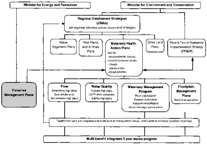
In understanding the development of the GERFMP, a clear understanding of the relationships between Victoria's resource management frameworks, and the linkages between management planning processes, are both important.
For example, fisheries management is within the Government's Energy and Resources portfolio, while biodiversity, catchment management and water management are within the Environment and Conservation portfolio. Within the Environment and Conservation portfolio, habitat and environmental planning outcomes are delivered through an integrated framework of regional catchment strategies and catchment action plans (salinity, water), river health plans, bulk water entitlements, streamflow management plans and Victoria's whole of Government Biodiversity Strategy. This portfolio also includes the Flora and Fauna Guarantee Implementation Plan (FFGIP), addressing:
- instream temperature profiles
- flow patterns
- sedimentation
- removal of woody debris
- fish passage impediments
- threatened species actions
As an overarching framework for aquatic environmental management, the Victorian Government is currently developing a State River Health Strategy (SRHS) to set the directions for all the major management functions that affect the health of rivers and their associated floodplains and wetlands. The SRHS will:
- identify environmental, recreational, cultural, social and economic assets for the State's waters, and the current condition of the asset and its comparative community value;
- identify processes threatening these values and the severity of the risk involved;
- identify opportunities for restoration of any degraded values and requirements for restoration;
- set broad priorities for action; and
- identify the key specific actions required and their overall priority (for example if flow is a threat, then a streamflow management plan may be required; if the threat is increased incidence of algal blooms, then a nutrient management strategy will be needed).
More detailed catchment based waterway health action plans (WHAPs) based on the SRHS will be developed by each Catchment Management Authority (CMA).
Actions under the FFGIP and the WHAPs will deliver many of the desirable fisheries outcomes identified in the GERFMP, but ares eparate to direct actions under the GERFMP.
The habitat and environmental issues identified in each of the issue-specific action plans, including fisheries management plans, will be integrated and articulated in each WHAP as river health objectives for the major river reaches within each catchment.
A reporting program that will enable monitoring and achievement of both resource condition and implementation targets in these processes can be included in the WHAP framework to illustrate how the issues identified in the GERFMP are being addressed.
There are a number of other documents that form part of the strategic planning framework affecting the Goulburn River region. These include:
Nationally based
- Draft Murray-Darling Basin Commission Native Fish Management Plan
- National Fishing Code of Practice
State based
- State Environment Protection Policy (Waters of Victoria)
- Draft Heritage Rivers Plan
Catchment based
- Goulburn-Broken Catchment Management Strategy
- Fishing Tourism Action Plan 2000 - 2003 and Regional Tourism Strategy
- Draft Waterway Strategy for GoulburnBroken Catchment
Planning framework
Locality based
1. Lake Eildon Storage Management Plan
2. Lake Nagambie Storage Management Plan (Water Quality and Biodiversity Strategy)
3. Upper Goulburn Recreational Waterways Strategy
4. Yea River Stream Flow Management Plan
5. King Parrot Creek Stream
Flow Management Plan
6. Goulburn Broken Water Quality Strategy
7. Lake Eildon National Park Management Plan
8. Shire planning schemes
1.2 Planning Framework
The Fisheries Act 1995 (the Act) and fishing regulations provide Victoria's framework for sustainable use of living aquatic resources, protection of fish habitats, promotion of sustainable quality recreational fishing opportunities, facilitation of access for a range of uses, and community involvement in fisheries management.
As set out in the first objective of the Act, the over-riding principle in the management of Victoria's fisheries is that they should be managed on an ecologically sustainable basis.
Throughout the GERFMP, the concept of sustainability of fisheries is stated or implied and refers to the principles of Ecologically Sustainable Development1 as they apply to fisheries.
Part 3 of the Act sets out the legislative framework for developing inland fisheries management plans. Under Part 3,
- the purpose of a fisheries management plan is to specify policies and strategies for the management of the fisheries on an ecologically sustainable basis, having regard to recreational, commercial, traditional and non-consumptive uses of the resources; and
- public authorities (such as catchment and water managers) must have regard to relevant fisheries management plans and, before taking any action that is inconsistent with a fisheries management plan, must consult with the Secretary of DNRE.
In accordance with this framework, guidelines for the development of the Goulburn-Eildon Region Fisheries Management Plan were published in the Government Gazette on 13 May 1999 (See Section 4.4: Appendix C).
Victorian Government policies on the stocking of native and salmonid fish, translocation of fish, and biodiversity conservation are also important parts of the framework for the GERFMP.
The guidelines and Part 3 of the Act describe the scope, aim, process and key features of the GERFMP. In addition to these legal requirements, the GERFMP must be structured so that key fishery attributes are described, and Goals and Objectives are provided to guide future management.
These Goals and Objectives are a blend of ecological need and the aspirations of the users of the fishery. This blend forms the vision for the future of the fishery. As such, the GERFMP is jointly 'owned' by all that have an interest in the resource.
The Fisheries Co-Management Council has overseen the Fisheries Management Planning process and has ensured that the planning process has conformed to the requirements of the Act and the guidelines published in the Government Gazette.
The appropriateness of the GERFMP's provisions and the level of success achieved will be measured by the degree to which overall and specific Goals and Objectives are met. It will be necessary for managers and anglers to monitor this collectively on an ongoing basis.
The purpose of the GERFMP is to identify required actions.
As more information on the fishery comes to light, management requirements will change and new needs will be identified. Also, the aspirations of anglers and fishing tradition will continue to evolve and subtly change over time. For these reasons it will be necessary to review and update the GERFMP from time to time.
Two fundamental factors that determine what is possible in terms of fisheries management in the mid Goulburn River are the current Bulk Entitlement and related water release practices, and the water temperature regime that results from the low-level off-take of water from Lake Eildon during the irrigation season.
Both factors severely limit the scope for restoration of healthy native fish populations in this part of the system. Both are also among a number of potentially threatening processes listed under the Flora and Fauna Guarantee Act 1988 affecting aquatic ecosystems in Victoria. Both factors also conflict with the protection of beneficial uses of Victoria's public waters and the intent of the State Environment Protection Policy (Waters of Victoria).
While the GERFMP recognises these impediments and threatening processes, the fisheries management strategies and actions contained in the GERFMP have been developed in the context of current water management arrangements. Major changes in the fishery in the future will act as triggers for reviewing the GERFMP.
Examples may include:
- changes to water flows, temperatures and release patterns;
- implementation of Flora and Fauna Guarantee Act 1988 Action Statements that address threats to aquatic ecosystems; and/or
- the provisions of the revised State Environment Protection Policy (Waters of Victoria).
1.3 Goals and Objectives
The goals, objectives, and policies in the GERFMP encourage maximisation of the opportunities provided by the fish resources of the upper Goulburn River catchment.
The goal of the GERFMP is:
to achieve the best possible match between the fisheries management arrangements and Victorian recreational fishers' aspirations for the fisheries in the upper Goulburn region.
In so doing, it must:
- ensure that the use and management of the fishery resource is consistent with the principles of ecological sustainability;
- ensure that the management of the fishery is consistent with other conservation and natural resource management aims of the Department of Natural Resources and Environment (DNRE) and other agencies (Goulburn-Murray Water and the Goulburn Broken Catchment Management Authority); and
- develop guidelines for the resolution of issues between user groups.
The objectives of the GERFMP are:
- to manage the fisheries of the Goulburn/Eildon area to provide a wide variety of fishing experiences with year-round fishing opportunities for both native and introduced species;
- to manage with a view to developing the fisheries to their full sustainable potential; to promote improvements of aquatic and riparian habitat in relation to a wide range of threatening processes;
- to promote improvements to the opportunities for improved production or access to target fish species;
- to provide for the conservation and enhancement of recreational fishing target species and other freshwater fauna within the system;
- to involve relevant resource managers in the fisheries management process and consult/negotiate with them in relation to possible positive outcomes for the fisheries resources and fish habitats;
- to provide for the positive input of resource users in the fisheries management processes for the area;
- to facilitate processes for improvement of access and facilities within the GERFMP area; and
- to achieve the best possible match between the fisheries management arrangements and Victorian recreational fishers' aspirations for the fisheries in these waters.
The fisheries management tools that may be used to implement the GERFMP include fish stocking, fishing regulations, habitat restoration, fisheries research and assessment, education andenforcement. The limitations of fish habitat and other external factors strongly influence what these tools can achieve in any water.
However, given the range of fish habitats covered by the GERFMP, it should be possible to meet most of the wide range of aspirations that anglers have for inland fisheries in this area. The GERFMP sets out the management objectives and current management arrangements based on previous consultation primarily with recreational fishers. This was seen as a logical starting point for the GERFMP. While its form and content are largely determined by the Fisheries Act 1995, the details of the final version were derived from responses to a discussion paper circulated for public comment prior to the writing of the GERFMP.
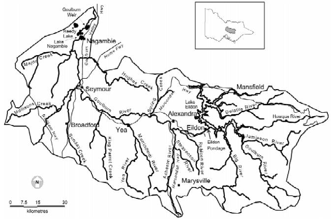
Firgure 1: A map of the upper Goulburn River catchment showing the major tributaries and major storages.Urban centres and highways are shown. The inset shows the location of the catchment within Victoria.
1.4 Background
The upper Goulburn River catchment includes the Goulburn River and all inflowing tributaries, upstream of Goulburn Weir. The area relevant to the GERFMP also includes a number of storages and impoundments such as Lake Nagambie, the Eildon Pondage and Lake Eildon. The catchment area extends from the Great Dividing Ranges in the south-east to the Murray Plains in the west (Figure 1).
The major population centres in this catchment include Mansfield, Marysville, Eildon, Alexandra, Yea, Seymour, Kilmore, Broadford and Nagambie. These centres, together with the rural agricultural activities throughout the catchment, rely on the Goulburn River and its storages as a provider of quality water. The catchment comprises only 2% of the surface area of the Murray- Darling Basin but generates 11% of its water resources (UGWA 1998).
The catchment contains some of Victoria's, and possibly Australia's, most valuable waterways and water resources. The natural landscape and general condition of the waterways attract tens of thousands of visitors to the region annually, regardless of the season.
Recreational fishing is one of the most popular leisure pursuits in the region. In 1997, the North East contributed $118.8 million (or 11.4%) to the gross state expenditure on recreational fishing. In terms of activity, the North East region, of which the upper Goulburn catchment is a substantial part, attracted 17.6% of all recreational fishing activity in Victoria (Unkles 1997).
By far the most popular species sought by recreational anglers in this region were brown and rainbow trout, with over 70% of recreational fishers interviewed in the area identifying these species as a preferred catch target. Murray cod and redfin were also identified as preferred species with blackfish being sought by a smaller number of anglers.
The GERFMP will provide a means by which the fisheries of the upper Goulburn River can be managed in a manner that ensures that these fisheries and associated aquatic biological resources are utilised and developed in an effective, efficient and ecologically sustainable manner.
The GERFMP is consistent with the objectives of the Fisheries Act 1995 and with the principles of the Victorian Inland Fisheries Strategy, Ecologically Sustainable Development and Conservation of Biodiversity.
The GERFMP also notes the existence of the statutory requirements and contractual arrangements of Goulburn-Murray Water and Southern Hydro.
Part 2
Management Unit Descriptions, Issues & Specific Management Objectives
The area of the upper Goulburn catchment covered by the GERFMP was categorised into a number of specific management units, these being:
- Lake Eildon Tributary Streams
- Lake Eildon
- Eildon Pondage
- Goulburn River from Eildon Pondage to Seymour
- Goulburn River Tributary Streams: Eildon Pondage to Seymour
- Goulburn River from Seymour to Nagambie
- Goulburn River Tributary Streams: Seymour to Nagambie
- Lake Nagambie
- Off stream Wetlands and Billabongs
2.1 Lake Eildon Tributary Streams
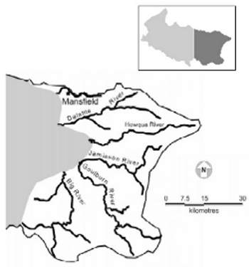
Figure 2: The upper Goulburn River and majortributaries above Lake Eildon.
The Lake Eildon catchment covers an area of approximately 3,900 km2, which includes the upper Goulburn River catchment and the basins of the Big, Howqua and Delatite rivers (Figure 2). Around 75% of the water yield of this catchment originates from the high rainfall southern section which, in contrast, represents only about one third of the total catchment area. Much of this southern section is mountainous and heavily forested, with a narrow, partly cleared floodplain in the lower reaches.
The southern tributaries all rise in similar country, typcally high (>500 m) mountains comprised principally of Palaeozoic sedimentary rocks such as mudstone, slate, shale and sandstone. Climate is montane with mean annual rainfall over 700 mm.
Streams of this zone are primarily in their mountain tract and are actively degrading and characteristically occupy steep walled 'V' shaped valleys. Outcrops of rock, loosened boulders and rock fragments are present in the valley walls, and boulders and pebbles in the stream bed. Stream morphology includes small to moderate sized waterfalls and rocky cascades in the upper reaches with more classical runs and pools in the lower sections of the zone.
Often the valley has a gently sloping spur on one side and a steep, undercut valley wall opposite due to lateral corrosion. Deeper pools are often present at these sites. Typically, the streams have irregular flows due to the substrate channel roughness. The catchments are predominantly well-vegetated and riparian cover is generally present on both banks.
The remaining 25% of the water yield for the catchment is derived from the drier northern sections where the plains and foothills have generally been cleared for grazing. The temperate climate provides a mean annual rainfall of over 700mm.
Northern tributary streams have a different form to the southern tributaries. They rise in the granitic Strathbogie Ranges before flowing through low, sedimentary sandstone hills to Eildon. Streams within this part of the catchment are relatively shallow, consisting of pool and riffle sequences with rock and gravel substrates. They are largely unregulated although there is some water abstraction for domestic and stock requirements along the lower reaches.
Due to the concentration of intensive land use and population, waters draining this area, including the Brankeet, Woolshed and Merton Creeks, tend to carry higher loads of nutrients, sediment and bacteriological indicators.
The township of Mansfield is the largest regional centre in the north of the catchment area, with many smaller, more isolated townships such as Howqua, Jamieson and Kevington in the southern foothills.
Highly regarded areas for camping, prospecting, snow skiing, four-wheel drive motoring and fishing are found within this region.
2.1.1 Geomorphology
A. Delatite River
The Delatite River rises in the steep hills behind Mount Buller and Mount Stirling. The stream profile has three distinct sections that influence the stream morphology. These consist of the upper reaches above Mount Stirling and Mount Buller, the area from Mt Stirling to Mirrimbah, and the area from Mirrimbah to Lake Eildon. The very upper reaches of the stream flow through well-forested catchment with the riparian vegetation dominated by tea tree, ferns and sedges. The stream is small and shallow with generally unbroken flow. Substrate includes gravel and silt. Woody debris is present and forms some small weirs in places.
From Mount Stirling to Mirrimbah the stream rapidly descends in altitude. This section is still well-vegetated but due to increased stream gradient and velocities, the substrate is mostly large boulders and bedrock with some areas of coarser sediment. Water flow is irregular and large pools are rare.
Downstream of Mirrimbah, the Delatite undergoes a further change, and by Merrijig has entered its valley tract and flows through a relatively broad valley to Lake Eildon. In this section, the stream form is the classic pool, riffle, run sequence interspersed with
occasional bedrock bars. Pools increase in size and depth downstream. The substrate is comprised of boulders, pebbles and coarse sediment. Fine silt and detritus are confined to the slower flowing areas and backwaters. Riparian vegetation is mostly cleared and replaced with exotics such as willows.
Some remnant native vegetation is still present in patches. The watershed in this area is extensively cleared and principally used for grazing.
B. Goulburn River
The upper reaches of the Goulburn River flow through well-forested catchment and riparian vegetation dominated by tea tree, ferns and sedges. The stream has a boulder and gravel substrate and shallow pools. Woody debris is present and in some places forms small weirs when it covers the width of the stream. Downstream of Woods Point the stream increases in size, but maintains the pool, run, riffle sequence. The substrate is mostly comprised of boulders, pebbles and coarse sediment although fine sand, silt and detritus are present. The finer material is confined to the slower flowing areas and backwaters. Pools generally get larger and deeper downstream. Riparian vegetation is mostly native and has been cleared on the occasional wider river plain and near the sites of the old towns. Willows, blackberries and cape broom are common.
C. Howqua and Jamieson Rivers
The Howqua and Jamieson Rivers are similar to the Goulburn River. All of these streams are in the mountain tract and are beginning to undergo transition to its valley tract as they reach Lake Eildon. As the valley floor widens, some land clearing has taken place on the gentler slopes. Land use in these areas is typically grazing with some small hobby-farm holdings. Riparian vegetation in the upper sections is native, commonly tea tree on both sides of the stream. On some of the cleared flats and particularly along the lower reaches, often only one bank is well-vegetated, and introduced species, primarily willows and blackberries, are common.
Some bank erosion is present in the lower part of the Howqua River in the Tobacco Flat area.
D. Big River
The Big River is still in the mountain tract and its valley is narrow and deep where it flows into Lake Eildon. The catchment is wellforested, and native vegetation is present on both sides of the stream. The extreme upper reaches of the stream, above Stockmans Reward, are small with boulder, pebble and gravel substrate. Some instream vegetation is also present and the flow is unbroken.
Downstream of Stockman's Reward the river has a bedrock, boulder and sand/gravel substrate with silt areas in the slower flowing sections and backwaters. Numerous small (<1 m) cascades are present over bedrock bars or from woody debris dams. Generally the stream is much wider than deep. The pools are generally shallow (<1 m).
Downstream of Enoch's Point to Lake Eildon, the river develops into a larger stream. Substrate is principally river boulders and gravel with some bedrock bars present. Deep pools are present where undercutting of the slope has occurred. Woody debris is present and forms log jams in some areas. Fine gravel, sand, silt and detritus are found where the current is slow. Before its confluence with Lake Eildon the Big River is a relatively large, deep (many areas >1 m) stream.
E. Northern tributaries: Ford Creek/Ancona Valley/Brankeet Creek
These streams rise in lower altitude hills and have relatively small catchments compared with the southern tributaries. The streams have a general pool and riffle sequence but are primarily small and shallow. The upper reaches of the catchments have patches of forest and the streams have some areas of native riparian vegetation. However, much of the catchment and stream banks have been cleared. Riparian vegetation is restricted to a discontinuous band along the banks and willows and other introduced vegetation are common. The stream substrate is generally comprised of sand and gravel, most of which has been introduced into the stream from corrasion of the stream banks. Rock bars are present in some locations. Some sections of the streams are incised into the floodplain. Flows are variable and can be very low in the drier months.
2.1.2 Water management
The upper Goulburn River and tributaries above Lake Eildon are unregulated for water supply purposes. However, some streamflow barriers are employed for discharge monitoring and off stream diversions. A concrete weir measures flow in the upper Goulburn River 6 km upstream of Jamieson on the Woods Point Road (SI 405219, Goulburn River at Doughertys; annual average flow of 375,000 ML).
A Goulburn-Murray Water private diversion licence allows extraction of approximately 130 ML for irrigation and domestic and stock use each year. The type and nature of diversion structure is available in individual customer files, but is not routinely recorded in Goulburn-Murray Water entitlement databases. Tributaries to the upper Goulburn River system include Ford Creek and the Delatite, Howqua, Jamieson, Big and Taponga Rivers. Licensed extraction for domestic and stock use occurs from almost all of the tributary waterways. Entitlements of more than 100 ML/ yr are licensed on Boggy Creek, the Delatite River and the Jamieson River. In some cases, extraction facilities may exist on pools formed by streamflow barriers (such as a diversion weir for snow making water supply).
The Howqua and Big Rivers are declared Heritage Rivers under the Heritage Rivers Act 1992. Licensed diversion entitlements exist on the two rivers, but the Act prohibits the construction of new barriers to passage of aquatic fauna and new diversions unless approved by the Governor in Council.
2.1.3 Environmental issues
Environmental issues in this zone include:
- nfestation of blackberries and cape broom, which has occurred in many reaches in this section and is limiting riparian diversity and restricting angler access;
- willows, which require control in some areas such as the lower reaches of the Goulburn River upstream of Jamieson;
- effects from past gravel extraction to the lower reaches of the Delatite River;
- ensuring that existing and future residential, tourism, agricultural, mining and other developments in the zone do not adversely affect water quality and quantity; l uncontrolled stock access to the lower reaches of rivers;
- the presence of the nationally endangered species barred galaxias, Galaxias fuscus, which is confined to small headwater areas in a few tributaries of the Goulburn and Howqua rivers;
- the presence of the nationally endangered spotted tree frog, Litoria spenceri, which occurs in parts of the Taponga, Howqua, Jamieson, upper Goulburn, Black and Snake rivers;
- the presence of Macquarie perch which have been stocked into the lower reaches of the Howqua River and may be present in the lower reaches of other Eildon tributaries due to movement from the Lake Eildon Macquarie perch population; and
- the Howqua River Heritage River status is based on both recreational fishing and spotted treefrog conservation values.
The GERFMP acknowledges the need for carefully planned trout exclusion trials aimed at protecting the threatened spotted tree frog in Whites Creek, a tributary of the Taponga River. It also recognises and supports the trout exclusion works undertaken to protect thebarred galaxid in small headwater streams in the Goulburn catchment area, such as the Morning Star, Raspberry and Godfrey creeks.
2.1.4 Access and facilities
Access varies with each stream but in general most of the lower reaches of these streams have reasonable access at reserves, road crossings and tracks. Access becomes more difficult in the extreme upper reaches where it is restricted to creek crossings and some reserves.
The Delatite River has some bridge crossings between the weir and Merrijig, and has several access points upstream to Mirrimbah.
The Howqua River has very good 4WD access via the Howqua River Road which joins the river at several places including Running Creek, Tobacco Flat, Sheepyard Flat and Tunnel Bend.
The Jamieson River has access in the town of Jamieson and for a short way along the Licola Road. Access is then restricted to the camping areas at Granny's Flat and Wren's Flat and to some 4WD access tracks.
The Goulburn River has many access points from Jamieson up to Woods Point including numerous spots through Kevington and Gaffneys Creek to Woods Point. Beyond Woods Point, access by 4WD is available to some Goulburn River headwater locations such as Black River.
The Big River has very good access from the Big River Road up to Enoch Point. The upper reaches of the Big River have very good access via numerous campsites downstream from Stockman's Reward. Road crossings and tracks give access to other fishable streams in this area such as the Torbreck River.
The northern tributaries in this section (Ford, Ancona, Brankeet, etc) can be accessed with permission over private property or at road crossings.
2.1.5 Current fishery
These waters are valued most highly by anglers as trout fishing streams and as spawning streams that contribute to annual recruitment of brown trout, in particular to Lake Eildon. This applies particularly to the Big, Delatite, Goulburn, Howqua and Jamieson Rivers. Throughout the length of most of these Lake Eildon tributaries, anglers take abundant small trout of around 200 g, with occasional larger trout up to 2 kg. To varying degrees in the lower reaches of all of the Lake Eildon tributaries, anglers also target Murray cod, golden perch, blackfish, redfin, carp, roach and tench.
The Delatite River holds many small rainbow and brown trout in its upper reaches even in drought conditions. The section of river from Merrijig to the Jamieson road bridge holds quality brown trout and smaller numbers of rainbow trout but numbers may be rapidly reduced by excessive angling pressure. Murray cod, redfin and freshwater spiny crayfish are targeted by anglers in the lower reaches.
Years of low water levels also impact severely on this section and fish kills can occur. The section from the Jamieson road bridge to Lake Eildon varies in angling quality from year to year with carp moving into this area in years of low flow.
The Jamieson River is a popular trout stream that contains roughly equal numbers of small rainbow and brown trout (up to 200 g) as well as a few larger fish. Some small redfin and river blackfish are also caught in the lower reaches. An annual spawning run of Macquarie perch was known to take place in this river when the species was more prevalent in the lake.
The upper sections of the Howqua River provide good trout fishing for both brown and rainbow trout with most fish generally less than 350 g.
The Goulburn River offers reasonable access to the angler but fishing quality can change due to variable spawning success each year. Brown trout average around 220 g with some fish up to 1.8 kg. Rainbow trout are generally smaller.
The Big River is an important trout nursery stream for Lake Eildon with extensive brown and rainbow trout spawning in the upper reaches. It contains small rainbow trout around 200 g and brown trout to 2 kg. Small redfin and river blackfish also occur in the lower reaches. Some fishing for brown trout is undertaken via boat access from the lake.
2.1.6 Specific objectives and fishery management strategies
The GERFMP recognises that most of the Eildon tributaries are primarily high use trout fisheries and therefore require specific management actions.
The goals for the fisheries in the Lake Eildon tributaries focus on:
- continued and improved opportunities for trout fishing based on naturally reproducing, wild trout populations in healthy upland streams;
- enjoyment of unspoiled and peaceful surroundings;
- the opportunity to take trout regularly and large trout occasionally; and
- the development of mixed species opportunities in downstream reaches.
The management objectives and strategies for the fisheries in these waters have been developed accordingly.
Wherever possible, anglers' concerns about trout numbers and the impacts of fishing will be addressed through habitat improvement and fishing regulations. Although acute natural events such as drought and floods can have negative impacts on trout fisheries, there is often nothing practical that can be done to offset such effects. Stocking trout in these streams (for instance to compensate for drought impacts) has not been considered an option in recent years, on the basis that recruitment is best left to the wild trout population. Trout populations have shown a remarkable capacity to recover when conditions after such events recover.
The challenge for managers is to ensure that man-made impacts do not compound the effects of natural events. Management arrangements that can be adapted for the situation, similar to current game bird (duck) management, may be appropriate for sections of these streams. For example, when trout populations are low in times of drought, lowering bag limits to preserve the stock from over fishing may be considered. When stocks recover the bag limits would then be increased.
The fisheries management objectives for these waters recognise the importance of many of them as popular trout fishing streams and as spawning streams that contribute to the trout populations that support the popular trout fishery in Lake Eildon.
The specific fisheries management objectives are to:
- manage populations of rainbow and brown trout so the number and quality (size and condition) of fish best match angler aspirations across the entire season;
- ensure that the level of use does not threaten the natural sustainability of the trout populations; and
- cater for as wide a range of recreational angling opportunities and angling styles as possible within the confines of fishery sustainability and maintenance of recreational and conservation values.
The major impediments to improved recreational fisheries in these streams include:
- the high levels of visitor usage, particularly in areas that are more accessible and during holiday periods, and the resulting impacts on the fishing experience;
- high summer water temperatures and low flows in many of the streams affecting the behaviour, growth, survival and productivity of trout in particular; and
- excessive nutrient and sediment loads, erosion, heavily modified or absent riparian vegetation in some areas and the impacts of exotic fish such as carp and roach and of exotic vegetation such as blackberries.
Management options therefore reflect the need to be flexible and specific to the individual fisheries and should:
- manage the stream fisheries with acknowledgment of the high angler use of some areas of the streams;
- assess the likely impacts of reduced or zero bag limit areas to counter the effect of angler pressure on some sections of the fisheries and review bag limits accordingly;
- recognise the linkage between trout stocks in Lake Eildon and the fishery in the lower to mid reaches of these streams;
- manage intensively fished streams to spread trout catches across the entire season;
- protect spawning trout from angler and waterflow management;
- support the creation and development, where practical and compatible with the existing fishery, of alternative recreational fishing opportunities, e.g. create a recreational fishery for Murray cod in lower reaches of the tributary streams;
- educate anglers on alternative angling opportunities within the management area, such as blackfish, redfin, carp, roach and tench;
- manage the sustainable take of freshwater spiny crayfish;
- protect and, where possible, assist restoration of the Macquarie perch population;
- protect and, where possible, restore stream habitats, including physical structure, riparian vegetation, water quality and flows; and
- minimise the impacts of carp and reduce the numbers of carp, roach and tench.
The management strategies to meet the fisheries management objectives and address the issues listed include:
- maximising trout recruitment via protection of spawning trout such as maintaining a winter closed season for trout;
- managing trout harvest in respect to conditions such as maintaining a daily bag limit specific to seasonal conditions and trout standing stocks in high use locations, and regularly reviewing the effectiveness of this strategy and modifying to suit;
- developing alternative fisheries to encourage the utilisation of carp, and actively encouraging fishing activities and management programs aimed at controlling the impacts of carp;
- protecting vulnerable or endangered species: maintaining appropriate controls on the taking of freshwater spiny crayfish; acknowledging and supporting conservation work for spotted tree frog and barred galaxias; and fully protecting Macquarie perch and actively encouraging anglers to recognise and avoid harming this and other threatened aquatic species;
- promoting habitat restoration/ rehabilitation: instigating, undertaking, supporting or encouraging habitat restoration projects;
- developing special management arrangements for areas where high fishing intensity early in the season diminishes catch rates later in the season; and
- encouraging the development of stream flow management plans for all tributaries.
For further information refer to Part 3, Action Plan Research and Performance Indicators.
2.2 Lake Eildon
Figure 3. Lake Eildon.
Lake Eildon (Figure 3), situated approximately 140 km north east of Melbourne, is Victoria's most popular inland boating and fishing destination. The lake was formed in 1927 by the damming of the Goulburn River immediately downstream of its junction with the Delatite River. The first stage, initially known as the Sugarloaf Reservoir, had a capacity of 377,450 ML. The second stage was completed in 1955 and increased the capacity to 3,392,073 ML, making it the second largest water storage for irrigation in Victoria. The lake surface area at full supply level is 13,750 Ha with a shoreline of some 515 km and a maximum depth of 76.2 m.
Within a 10 km zone around the lake, there are two main urban centres; Mansfield to the north-east and Eildon to the south-west. A number of small urban centres also exist around the lake and include Bonnie Doon, Goughs Bay, Howqua and Jamieson. The major land use in the area is cattle and sheep grazing and forestry.
The lake is a very popular place for a number of recreational pursuits including sailing, water skiing, house-boating and camping as well as fishing.
2.2.1 Geomorphology
The landform around Lake Eildon reflects the weathering of massive rocks which has produced deep valleys and a drainage pattern of closely spaced first order streams. These streams eventually flow into the larger valleys of the Goulburn and Delatite Rivers. The impoundment of the Goulburn River and subsequent flooding of these valleys has produced a narrow lake with several inlets or 'arms' and many bays. The two main arms are the flooded Delatite and Goulburn River valleys.
In the lower reaches of the major inflowing streams, the flooding of the extensive floodplains of the river valleys has created a generally flat bottom profile for the lake. Depending on the lake level, these areas may appear in the storage as shallow flats. Steeper banks and narrow 'V' shaped valleys occur at the heads of the gullies where the water height is above the level of the drowned valley floor. The underlying sandstones are exposed on the steeper banks due to the erosion of the topsoil. Topsoil, overlain with silt, has remained on the flats and more gently sloping areas of the lake floor. The lake is narrow and seldom exceeds 2 km in width. The surrounds of the lake include a mix of cleared and forested land.
2.2.2 Water management
Lake Eildon supplies water to irrigation areas and urban systems. The storage also provides flood control for the Goulburn and Murray River systems and has hydro-electricity generation facilities connected to the Victorian electricity distribution network. The capacity of the storage is approximately double the average annual inflow.
A Bulk Water Entitlement (Eildon–Goulburn Weir) Conversion Order 1995 defines the storage and use of water in Lake Eildon and the wider Goulburn River system. The Order demands that water extracted from the Goulburn system be used to satisfy the following primary entitlements:
- domestic and stock allowances and water rights within the Goulburn component of the Goulburn-Murray Irrigation District;
- licences supplied from the waterway;
- domestic and stock supplies within the East Loddon, West Loddon and Normanville Waterworks Districts;
- sales water;
- additional supplies; and
- other bulk entitlement orders within the system.
This entitlement is discussed further in Section 2.4.2
2.2.3 Environmental issues
The rise and fall of the storage water level is the main factor that drives the quantity and quality of available habitat for fish in the lake. When its water levels are reduced, fish become concentrated in certain areas of the lake, making them vulnerable to overfishing and high water temperatures. The refilling phase can also cause problems for the fishery by resuspending sediments that contain nutrients and in some cases heavy metals.
The high sediment and nutrient loads of some inflowing streams are high priorities for remedial action.
Some concern has been expressed regarding mercury levels in fish throughout Lake Eildon. Further monitoring is required to quantify any risks.
Blue-green algae blooms, which warranted public notification, have occurred in the lake on two occasions in the past five years.
The illegal removal of wood from the lakebed is prevalent and has adverse effects on habitat availability.
2.2.4 Access and facilities
Access to the lake is generally very good with numerous boat ramps and vehicle access points. However, boat access via the concrete ramps around the Delatite, Goughs Bay, Bonnie Doon and Jamieson arms may be constrained by low water levels. When lake levels are low, boat access becomes restricted to only a few formed concrete ramps mainly in the Eildon area, including Jerusalem Creek and the Eildon Boat Harbour.
Illegal vehicular access occurs across the dry lakebed during times of low water. The recent low-water condition (1999-2000) has permitted the lengthening of ramps including Jerusalem Creek and Eildon State Park. Informal illegal boat ramps are also often used around the lake depending on water levels.
Boat fuel is available from floating barges at the Eildon Boat Harbour and Jerusalem Creek at all water levels and at the Bonnie Doon arm when the water level is suitable.
2.2.5 Current fishery
Lake Eildon is classified as a mixed fishery although trout and redfin are probably the most popular and sought after species. Redfin captures are commonly 1 kg or better and brown trout to 3 kg or more are not uncommon. Lower numbers of rainbow trout, which rarely exceed 1.5 kg are also taken. Carp, goldfish, Macquarie perch, tench, river blackfish, golden perch and Murray cod have also been reported from various parts of the lake.
Stocking of salmonids in the lake was halted in 1991 as the results of stocking trials at that time indicated that stocked trout contributed very little to anglers' catches. The fishery now relies on natural recruitment of both brown and rainbow trout from the numerous streams entering the lake. Native fish stocking has continued throughout this period. Some minor stocking of adult Macquarie perch translocated from Lake Dartmouth has also occurred in recent years.
The first privately sponsored stocking occurred in December 1999 when 200,000 rainbow trout fingerlings were stocked under the Rex Hunt FutureFish Foundation and the Eildon Action Plan. This group also sponsored the release of 48,500 golden perch fry and 25,000 Murray cod fry into Lake Eildon during 2001.
Lake Eildon anglers practice many versions of the sport, and techniques employed in the storage include bait, coarse, fly and lure fishing both from the bank and from boats.
Lake Eildon is open to fishing for salmonids all year round. The lake has a varied reputation regarding salmonids. It produces a mixture of small trout and some relatively large, wellconditioned fish. Brown trout are a more common capture than rainbow trout. The larger trout are targeted annually during the winter. Trolling is an accepted method to target these fish and the Big River arm is a popular area for this pursuit. Bank fishing for salmonids with lure, fly and bait is also popular, especially when the water is rising over the flats in late winter and spring.
Trout fishing declines in the summer months when the trout move deeper to avoid the warm surface waters. Those anglers wishing to catch trout at this time use appropriate methods such as down-rigging and deep bait fishing.
In the warmer months of the year, many anglers target redfin. This species is very popular with anglers and they use a variety of techniques including bait, trolling and lure casting. Apart from carp, redfin would be the fish most likely to be caught by the holiday or occasional angler, and the species is therefore very important in the Lake Eildon angling experience. Redfin up to 2 kg are regularly taken from the lake but most would be less than 400 g. Quality redfin fishing relies on anglers detecting schools of the larger fish, hence the more successful anglers are usually boat based. Redfin fishing in Lake Eildonn varies considerably between years.
Murray cod and golden perch are also present in Lake Eildon and are generally considered summer species. Murray cod were highly sought in the early 1990s when the fishing media contained favourable reviews of the cod fishing offered in the lake. The number of anglers targeting cod is suspected to have decreased since this time and is currently thought to be relatively low. However, cod are regularly taken from the lake, particularly in the Delatite Arm. The number of anglers specifically targeting golden perch is also thought to be relatively low at present, despite fish surveys indicating the presence of relatively high numbers of golden perch up to 3 kg (average weight just below 1.5 kg).
The lake contains large populations of carp and roach. Coarse fishing anglers often target these species.
2.2.6 Specif ic objectives and fishery management strategies
The goal for the fishery in Lake Eildon is to:
develop and maintain a year-round mixed species fishery, in particular for brown trout, rainbow trout, redfin, Murray cod and golden perch.
Two specific objectives identified by angler groups and related business interests are the improvement of the trout fishery, and the development of fisheries for golden perch and Murray cod. Specific trout angler objectives range from the continued opportunity to take wild brown trout in excess of 5 kg to regular catches of trout irrespective of size.
The specific fisheries management objectives are to:
- increase the knowledge base on the Lake Eildon fishery to assist in management of the fishery;
- maintain and enhance brown trout and rainbow trout populations to provide a year round trout fishery;
- develop fisheries for Murray cod and golden perch, and determine appropriate stocking strategies;
- encourage the taking of redfin, carp, roach and tench;
- protect the Macquarie perch population;
- improve the understanding of anglers' objectives, catch rates and satisfaction in relation to the Lake Eildon fisheries;
- improve habitat suitability for both adult and recently-recruited or stocked trout and native fish;
- minimise the impacts of carp; and
- improve legal access to the lake
The major impediments to improving the trout fisheries are:
- the lack of knowledge on limiting factors for trout in the storage;
- inconsistent water levels that do not provide suitable habitat for young juvenile trout (especially rainbow trout) at critical times of the year;
- natural brown trout and rainbow trout recruitment (from the inflowing streams) that is inconsistent from year to year, and may be significantly diminished because of habitat degradation in the catchment and further diminished during years of low winter-spring rainfall; and
- possible impacts of undesirable species of fish (eg carp) both in the lake and in spawning areas in the inflowing streams.
The major impediments to improving the fisheries for native fish are:
- the lack of knowledge on limiting factors for native fish in the storage;
- the lack of, or inadequate, natural recruitment of Murray cod and golden perch;
- that suitable physical habitat structure is either limited or exposed during periods of low water level;
- the large numbers of fish required to establish and maintain stocking-based fisheries in this large water at high water levels; and
- possible inter-specific and intra-specific stresses imposed by competition for food and habitat at low water levels.
The management strategies to meet the fisheries management objectives and address the issues listed include:
- maintaining an appropriate daily trout bag limit and the opportunity to fish for trout year round;
- investigating the annual recruitment of brown trout and rainbow trout from the Eildon catchment, and thus determining the needs and appropriate strategies for enhancement by stocking, either on a regular basis or under defined conditions;
- assisting/encouraging anglers to utilise the golden perch fishery;
- maintaining Murray cod and golden perch populations through regular stocking and monitoring, and assessing Murray cod and golden perch populations to determine the effectiveness of stocking programs;
- maintaining the State-wide size, bag and season restrictions for Murray cod; introducing bag and size restrictions for golden perch;
- undertaking a comprehensive creel survey, to gather data on angler preferences and satisfaction;
- conducting habitat enhancement trials aimed at improving the survival of juvenile fish and the catchability of adult fish;
- determining and promoting water management strategies that maximise survival and growth of recently recruited or released trout and native fish;
- actively encouraging anglers to recognise Macquarie perch and avoid harming these and other threatened aquatic species;
- actively encouraging fishing activities and management programs aimed at controlling the impacts of carp;
- undertaking analyses of mercury concentrations in the flesh of edible fish species; and
- defining and identifying legal access points to the lake when water levels are low in order to protect water quality.
For further information refer to Part 3, Action Plan Research and Performance Indicators
2.3 Eildon Pondage
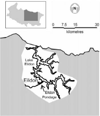
Figure 4. The Eildon Pondage.
Eildon Pondage (Figure 4) is located immediately downstream of the Eildon Dam.
It is a re-regulation storage facility constructed to contain flows released from the Dam to within the capacity of the Goulburn River channel. The Pondage has a surface area of 150 Ha with a capacity of 5,200 ML. Water levels within the Pondage fluctuate in response to demands for hydro-electricity and irrigation water released from the Eildon Dam. The township of Eildon (pop. 600) borders the northern side of the Pondage and relies heavily upon tourism, including tourism generated from fishing.
2.3.1 Geomorphology
The Pondage has a maximum depth at its gates of 10 m at full supply level. It has extensive shallower flats alongside the inundated river course. Water clarity and depth allows extensive weed growth on the clay/boulder/pebble substrate in these shallow areas. The old river course follows the hills on the eastern bank before veering toward the road bridge and following a straight line from the bridge to the Pondage gates. In the upper Pondage, numerous underwater rock bars and deeper holes are associated with the inundated river.
At full supply, water reaches the riparian sedges and grasses and a marsh develops on the eastern side of the upper Pondage. At extremely low water levels (when the Pondage is drained for maintenance) only the old river course holds water and it reverts to a flowing river with a boulder, gravel and rock substrate and a pool and riffle stream form.
2.3.2 Water management
The 5,200 ML Eildon Pondage provides controlled releases from Lake Eildon to the Goulburn River. The Pondage allows for flexible operation of the hydro-electricity generation turbines on the Lake Eildon outlets and other discharge valves. Water released for power generation during times of high electricity demand is held in the Pondage and regulated to provide a uniform discharge to the Goulburn River to meet irrigation or 'passing flows' demands. The discharges may occur through a gated weir structure or a small hydro-electricity generation plant operated by a private company, Pacific Hydro Investments.
Formerly managed by Goulburn-Murray Water (G-MW) and its predecessor organisations, the Eildon Pondage is now managed by Southern Hydro Partnership, the private operators of the Lake Eildon hydro-electricity generation turbines. Southern Hydro Partnership must ensure that releases to the Pondage are sufficient to meet the Goulburn River flows ordered by G-MW. Southern Hydro manages the levels of the Pondage according to its agreement with G-MW.
After negotiations between the Eildon community, G-MW and the Southern Hydro Partnership, minimum pondage levels over winter are to be maintained at one-fifth of capacity between the hours of 11am and 6pm. This may change due to the new power station coming on line.
2.3.3 Environmental issues
Environmental issues in this zone include:
- the effect of the rise and fall of the water level on food production for fish;
- increased turbidity of Pondage water associated with the regular rise and fall of the water level; and
- lack of diverse habitat due to the changing water levels.
2.3.4 Access and facilities
Access to the Pondage is excellent with numerous roads and tracks to the bank. Foot access to areas with no vehicle access offers the keen angler a chance to avoid the crowds. Boating access to the Pondage is normally not permitted and this is an issue for some anglers. The recent erection of a disabled persons' fishing platform in the lower Pondage has gained wide acceptance. Adjacent to the platform, the Lions Club of Eildon has erected an undercover barbecue area. This project has also enhanced the public usage of this fishery. Another project in planning is the construction of a disabled persons' toilet close to the pavilion. Anglers have suggested that more facilities be constructed around the pondage to cater for visitors.
2.3.5 Current fishery
Eildon Pondage is very popular for trout fishing and is managed as a 'put-and-take' fishery. It receives around 13,000 trout each year between September and April. Stocked fish range between 100 g and 4 kg. It is stocked with 3-year-old, 2-year-old and advanced yearling brown trout from the Snobs Creek Hatchery. Recent trials of stocking advanced yearling fish (200–250 mm) in OctoberDecember to cater for holiday fishing pressure appear to have been successful. In some years, the Pondage may also gain recruitment from immigrating trout on their spawning migration up the Goulburn River. However, this only occurs when the Pondage level is allowed to fall to that of the river and the gatevalves are opened.
The current annual cost of stocking the Pondage (year 2000) is estimated to be around $20,000, which is approximately 5% of the annual trout stocking budget for Victoria.
Boating is generally prohibited and there is a bag limit of 5 trout per person per day on the Pondage.
A 1994 creel survey of the Pondage and Goulburn River to Alexandra reported that the Pondage received the highest fishing pressure of this area. The fishery is primarily utilised by bait fishers (80%) with less than 5% of anglers fly fishing. The Pondage and Goulburn River to Alexandra are very popular with visiting anglers, the majority of whom come from Melbourne.
2.3.6 Specific objectives and fishery management strategies
The goals for the Eildon Pondage fishery are to:
offer anglers the year-round opportunity to take 2-5 kg brown trout and rainbow trout in this unique easily accessible put-and-take fishery, set in pleasant surroundings suited to family or group outings.
The specific fisheries management objectives are to:
- make large trout available to anglers for as much of the year as possible, within the limitations imposed by water management; while continuing to share the take of all fish among anglers of all abilities;
- improve fishing access for anglers of all ages and abilities; and
- as far as possible ensure that the trout stocking schedule is cost-efficient in terms of the percentage of released fish that are caught from the Pondage.
The main impediments or issues facing this fishery are:
- the high costs of stocking advanced yearlings, 2-year-old and 3-year-old trout;
- limited food availability and highly variable water levels restricting the trout carrying capacity of the Pondage;
- fluctuations in water level limiting access to fish and compromising angler safety;
- downstream escapement of stocked trout (recognising their contribution to the fishery downstream); and
- concerns that some skilled anglers take unfair advantage of the availability of stocked fish provided for the benefit of all anglers.
The management strategies to meet the fisheries management objectives and address the issues above include:
- maintaining a trout bag limit and the opportunity to fish year-round;
- assessing the need to restrict the individual daily take of large trout;
- promoting compliance with catch limits by a combination of angler information (including signage) and enforcement;
- assessing the potential of a Fishcare volunteer or someone from a similar program to aid management of this fishery;
- continuing to stock 8,000 yearling trout during the winter (subject to water levels) to provide a readily-accessible fishery while the stream fisheries are closed;
- continuing to stock 5,000 rising 2-year-old and 3-year-old brown and rainbow trout (i.e. a total 13,000 trout) annually;
- conducting a survey to determine angler catch rates, needs and satisfaction with their fishing experience, as well as the returns to anglers from releases of trout of different sizes and at different times of the year;
- undertaking a cost-benefit analysis for the management of this fishery;
- encouraging the development of fishing platforms and other aids to angler access; and l working closely with water managers and power companies to improve consistency and adequacy of the water level in the Pondage year-round.
For further information refer to Part 3, Action Plan Research and Performance Indicators
2.4 Goulburn River - Eildon to Seymour
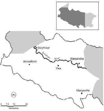
Figure 5: The Goulburn River between the Eildon Pondage and Seymour.
The section of the Goulburn River between Eildon and Seymour (Figure 5) flows through a relatively narrow, moderately graded floodplain below Lake Eildon. It is a highly regulated stream due to the demands of water transfer for irrigation and domestic use. It is the main conduit for water transfer from Lake Eildon to Goulburn Weir. Summer releases of water from Lake Eildon for irrigation maintain a cold (about 11-3°C) flow throughout the section. Winter flows are reduced to a minimum passing flow of 120-250 ML/d at the Pondage and are supplemented downstream by the inflowing feeder streams.
Land use is primarily agricultural (grazing), with some remnant native vegetation on the hills and steeper slopes in the lower end of the river section near Trawool. The township of Alexandra is the largest regional centre bordering the river in this area that also includes smaller ownships such as Thornton and Trawool. This section is an extremely popular recreational site, particularly for fishing. Boating is also becoming more popular.
2.4.1 Geomorphology
The Goulburn River in this section is in its valley tract and meanders across a distinct floodplain bounded by low hills. The stream in the top end of this section from Eildon Pondage to Alexandra has a boulder and gravel substrate. Bedrock reefs are present immediately downstream of the Pondage and at several sites downstream to Seymour. In times of low flow the stream has a characteristic pool, riffle and run sequence. At higher irrigation flows, many of the smaller riffles and rapids are over-topped and the river has a more unbroken flow pattern.
Downstream of Alexandra to the Cathkin/Molesworth area, the river changes and the rocky bed and banks are replaced with silts and clays. The river has fewer rapids and riffles as the flow becomes unbroken, regardless of the river height.
From Molesworth to Seymour the substrate includes shingle and clays. Instream woody debris is common along each bank and the pool run sequence becomes less pronounced. At Kerrisdale, the valley is constricted as the river flows through a narrow gap between the Highlands to the north and the Brown Range to the south. The stream reverts back to include some riffles and gravel substrates through this area. However, once past Trawool the river is beginning its transition to its plain tract as the valley begins to widen at Seymour.
Much of the surrounding catchment has been cleared, with only patches of natural vegetation remaining. Riparian vegetation is also mostly cleared along the entire section and is commonly only a single row of trees, discontinuous along both banks. In the upper reaches of the area willows are common. Native vegetation is more common downstream of Molesworth. Redgums and wattles are the main native trees in the lower areas of the section toward Seymour. The section of watershed between Kerrisdale and Trawool is perhaps the exception as it is well-forested and riparian vegetation also improves in this area.
2.4.2 Water management
The Goulburn River downstream of the Eildon Pondage is highly regulated to enable the transfer of water from Lake Eildon to Goulburn Weir at Nagambie. The major reason for water transfer is for distribution to the Shepparton, Central Goulburn, Rochester-Campaspe and Pyramid-Boort irrigation areas. There is also substantial extraction for irrigation, commercial, domestic and stock usage along this section. The Storage Operator (Goulburn-Murray Water) is responsible for maintaining and operating headwork structures, and will release water to meet primary entitlements at the request of the Authority holding the source entitlement. The obligation to provide these flows rests with the Authority. The Resource Manager (also Goulburn-Murray Water) must ensure that Authorities comply with their bulk entitlements and will keep basin water accounts.
River flows are consistently in the order of 8,000–11,000 ML/d during summer months. Flows in excess of 5,000 ML/d generally occur between September and late April in support of irrigation demand. Goulburn-Murray Water is obliged to limit releases during non irrigation months in accordance with the minimum passing flow defined by the Bulk Water Entitlement (Eildon–Goulburn Weir) Conversion Order 1995 (the Order) to conserve water resources in Lake Eildon.
The Order requires a minimum passing flow of 120 ML/d to the Goulburn River below Lake Eildon and the Eildon Pondage Weir. If inflows to Lake Eildon during the previous 24 months exceed monthly trigger volumes defined by the Order, the passing flow is increased to 250 ML/d on the first day of the following month. The minimum passing flow usually occurs between May and September, when water in storage is being maximised for the coming irrigation season. Releases from Lake Eildon usually increase after September to meet irrigation demands in the lower Goulburn Valley. Maximum summer releases are in the order of 10,000 ML/d.
A process is available under the Order to enable off stream lagoons and wetlands to be filled if certain conditions are met. An additional passing flow equivalent to a volume of up to 80,000 ML is available to be released for the duration of one day to the Goulburn River below the Eildon Pondage Weir during November. The water can only be released if passing flows are at 250 ML/d and five hydrological conditions prescribed by the Order are satisfied. Confirmation for the requirement and final approval must be obtained from DNRE. Off stream lagoons provide habitat for a variety of fish species, provide nursery areas for young fish, and contribute to food production and nutrient cycling of the main river (See Section 2.9). This process has not been used to date.
Some 30,000 ML of water stored in Lake Eildon is allocated for water quality dilution flows in the Goulburn River. The volume does not carry forward if unused and can only be released with the approval of the Resource Manager. Any release for water quality is not counted against entitlements.
The bulk water entitlements are Government policy and cannot be altered by G-MW or DNRE unless instructed by the Minister.
There are maximum rates of rise and fall for discharges from the pondage to the Goulburn River. The maximum rate of rise is 150 mm/h up to a maximum of 3,500 ML/d. An instantaneous fall of 150 mm can occur followed by falls of 30 mm/hr, up to a maximum of 450 mm on the first day. Thereafter the rates are at 30 mm/hr and 300 mm per day.
Sections of the Goulburn River downstream of Lake Eildon to its confluence with the River Murray are proclaimed as a Heritage River under the Heritage River Act 1992.
2.4.3 Environmental issues
Environmental issues in this zone include:
- river regulation issues such as the timing, temperature and volumes of outflows from the Pondage (for example: when the lake level is low, the high release rates draw warm (18-19oC) surface water down into the outlet tower and into the Pondage and river, while at normal levels the temperature of water released into the river can be as low as 12-13oC);
- the impact of exotic vegetation;
- stock management along banks;
- narrow and/or absent riparian buffers;
- bank erosion/slumping possibly exacerbated by prolonged high flows, rapid changes of river height and lack of riparian vegetation;
- possible impacts of boating;
- impacts of past gravel extraction;
- water quality issues associated with a number of the above;
- impacts of prolonged low and high flows and of rapid changes in river height on fish habitat, reproduction and fishing; and
- aquaculture ventures located on some streams which may affect downstream water quality.
Gilmore's Bridge near Thornton shows a loss of aesthetic and habitat values through litter, worn areas of bank and car parking.
Victoria's Index of Stream Condition (ISC) rates the Goulburn River between Eildon and Nagambie as being in poor or very poor condition (1998-99 data). The ISC integrates information of the major components of our river systems that are important from an ecological perspective. It brings together information on the current river flow regime, water quality, condition of the channel and riparian zone, and the invertebrate communities living in the stream.
2.4.4 Access and facilities
From Eildon to Alexandra there are numerous points for bank fishing and wading access along both sides of the river, plus four bridge crossings, these being at Thornton, at Gilmore's Bridge, at Acheron (the Breakaway) and on the Maroondah Highway at Alexandra. Angling pressure in these areas can be intense at times, particularly when the river is flowing below 4,000 ML. The low water levels allow access to waters that were previously inaccessible when the river was high.
A canoe launching site is located on the river downstream of the Pondage and some other more informal canoe launching sites are also present further downstream. There is a public boat ramp at the Maroondah Highway Bridge at Alexandra, and a boat ramp for the use of guests is provided at the Twin Rivers caravan park. The Goulburn River in this section is covered by boating regulations.
Access becomes more difficult from Alexandra to Trawool where it is restricted to some road bridges and isolated reserves. Access sites include the reserve at Cathkin, the Molesworth boat ramp in the caravan park, the reserves and boat ramps on the Killingworth Road near Yea and Ghin Ghin, the bridge at Trawool, and the reserve at the end of Greenslopes Road. Other access is over private property (with permission) or along the river by boat. Bank access is available at several locations along the Trawool-Tallarook Road. Two boat ramps are present at Seymour.
2.4.5 Current fishery
The area directly below the Pondage wall for 200 metres is closed to angling all year round. There is presently a possession limit of five trout per day over the balance of the river. Trout regulations in their current form do not prevent anglers from fishing for species other than trout in trout streams during the trout closed season. This may result in anglers disturbing trout spawning redds during the closed season.
The upper reaches of the Goulburn River in this section, particularly from the Pondage downstream to Alexandra, are generally recognised to support one of Victoria's top riverine trout fisheries. The river is generally shallow in the reaches above Alexandra and this area is particularly popular with fly fishers as well as bait and lure anglers. The section of river from Eildon Pondage to Alexandra contains brown trout to around 2 kg and lesser numbers of rainbow trout to 1.3 kg. Small numbers of redfin are also present as are goldfish and increasing numbers of carp. Although redfin are not common within this section, a number have been taken around 1 kg in recent times.
Downstream of Alexandra the morphology of the stream is more suited to bait and lure casting techniques due to the change of the river into longer, deeper pools and steeper vegetated banks. Below Alexandra there are still good numbers of trout, with the brown trout probably larger on average (fish up to 3.5 kg are not uncommon). In the lower reaches of this section, particularly between Yea and Seymour, Murray cod and golden perch are taken occasionally, however neither species supports a fishery in this area. Macquarie perch have been reported from the mouth of the Yea River.
Freshwater spiny crayfish have been keenly sought by recreational fishers, particularly between Seymour and Yea. However, the current status of this fishery is not known but is thought to have declined. The focus area for crayfish is now centred in the Goulburn downstream of Seymour.
2.4.6 Specific objectives and fishery management strategies
The specific objective for the fishery in the Goulburn downstream of the Pondage is to:
manage the fishery to maximise the angling potential of the wild trout populations in the upper section and the development of a mixed fishery in the downstream section.
The broad angler goals for the Goulburn River above Alexandra are strongly focused on brown and rainbow trout. Anglers' aspirations range from the opportunity to take wild brown trout in excess of 2 kg to regular catches of trout irrespective of size.
Downstream from Alexandra, anglers value the increasingly mixed species fishery, targeting redfin and large brown trout. From Yea to Seymour, anglers also target Murray cod, golden perch and carp. The main fisheries management aims are to strengthen the foundation of this fishery through protection and enhancement of fish habitat quality and to explore alternative management strategies to enhance the fishery in this section.
The fisheries management objectives for the mid Goulburn River, from Eildon to Seymour, are to:
- determine limiting factors to the wild trout populations;
- ensure adequate natural recruitment to support the trout fishery;
- minimise interference with spawning trout;
- encourage the taking of redfin, carp and tench;
- minimise the impacts of carp and reduce numbers of carp and tench;
- encourage the taking of small trout and enhance the opportunity to fish for large trout;
- protect and, where possible, restore stream habitats, including physical structure, riparian vegetation, water quality and flows;
- improve angler access and alleviate crowding and localised intensive fishing pressure at limited access points;
- assess the status of the freshwater spiny crayfish population and protect it if necessary;
- prevent escapes of fish from fish farms;
- monitor downstream water quality from fish farms; minimise impacts of low flows in non irrigation period;
- enhance the mixed-species fishery in the lower reaches of this section; and
- identify sources of sediment and nutrients that are impacting on important fish habitats.
The major impediments or issues facing the fisheries are:
- uncertain impacts of fishing pressure on trout numbers and size composition;
- impacts of low regulated winter flows on natural recruitment of trout;
- limited access to the river and the resulting high fishing pressure at access points;
- uncertainty about public rights of access to much of the river frontage;
- lack of knowledge on the status of fish populations in the river upstream of Seymour;
- uncertain impacts of escapes from fish farms;
- impacts of fish farms on downstream water quality; and
- excessive nutrients and sediment loads, erosion, heavily modified or absent riparian vegetation in some areas, and the impacts of development, exotic fish such as carp, and exotic vegetation such as blackberries.
The management strategies to meet the fisheries management objectives and address the issues listed include:
- maintaining a daily bag limit of trout;
- maintaining a winter closed season for trout;
- continuing the current study of trout populations and their responses to habitat conditions and fishing;
- undertaking studies to address uncertainties about trout spawning habitat, flow rates and fishing impacts on trout populations;
- determining the status of fish populations upstream of Seymour;
- actively encouraging fish farms to prevent escapement of fish into the river system;
- actively encouraging fish farms to adopt best practice procedures on water quality of effluents;
- encouraging the taking of carp;
- actively encouraging fishing activities and management programs aimed at controlling the impacts of carp;
- working in conjunction with the Catchment Management Authority waterways program and seeking other assistance to restore priority habitats that will benefit the long-term management of the fishery;
- improving collaboration between fishery managers, Goulburn-Murray Water and angler groups to secure adequate flows during the trout spawning seasons;
- seeking a review of the environmental allocation for the Goulburn River with the purpose of ensuring sustainability of the fishery, particularly downstream of the Eildon pondage to the Rubicon River junction;
- seeking some of the environmental allocation of 80,000 ML to enhance low water flows from Eildon Pondage in the non irrigation period;
- promoting collaboration between fishery, catchment, water and Heritage River managers, and private landowners to achieve improved angler access by installing walking tracks and clarifying access rights;
- assessing freshwater spiny crayfish populations and reviewing regulations to ensure effective conservation; and
- identifying and defining public access points, and improving angler access opportunities through signage and development of land holder relations.
Under the current trout management policies of DNRE and VRFish, trout are not stocked in the mid Goulburn River and its tributaries.
For further information refer to Part 3, Action Plan Research and Performance Indicators
2.5 Goulburn River Tributary Streams – Eildon to Seymour
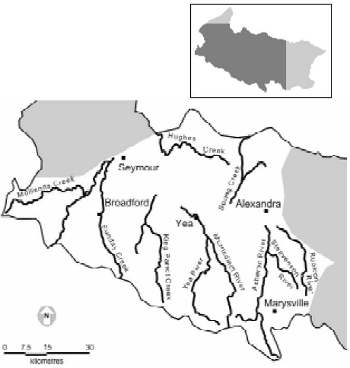
Figure 6: The major tributaries of the GoulburnRiver between the Eildon Pondage and Seymour.
Goulburn River tributary streams in the area from Eildon to Seymour (Figure 6) such as Snobs Creek, the Rubicon River, Acheron River, Taggerty River, Yea River, Sunday Creek and King Parrot Creek all flow from similar country. This country typically features high (>500 m) mountains comprised principally of Paleozoic sedimentary rocks such as mudstone, slate, shale and sandstone and some granite.
The climate is montane with a mean annual rainfall of over 700 mm. In general terms, the Rubicon River and Snobs Creek display similar attributes to the upper Goulburn River and tributaries zone. However, northward migration of the Great Dividing Range in the Kinglake area has modified the drainage of the Acheron and Yea rivers as well as of King Parrot Creek, thus retarding down cutting. Typically, these streams have low gradients along their length. This profile is markedly different from the steep gradients of the tributary streams in the upper Goulburn River.
Mollisons Creek and its main tributary, Sugarloaf Creek, rise in a temperate climate with lower rainfall and their source is the lower granitic hills around Pyalong.
Home, Johnson, Ultima Thule and Spring creeks rise in the low foothills north of the Goulburn River between the Highlands and Maintongoon.
2.5.1 Geomorphology
A. Snobs Creek
In the upper reaches, Snobs Creek is a small stream in a narrow, well-forested catchment. The riparian overstorey consists of Mountain Ash and in some places myrtle beech with an understorey including tea tree or ferns, depending on the aspect. Substrate in the upper reaches is fine silt, sand and gravels. The stream is actively degrading and a significant waterfall is present.
Downstream of the waterfall to the Goulburn River the stream gradient is relatively high and the substrate is predominantly boulders and pebbles. Some fine sediment is present in areas of lower flows. The creek has a relatively steep gradient in this section and has no floodplain until below the Goulburn Valley Highway bridge. Riparian vegetation is present along the length of the stream except for some understorey clearing between the highway bridge and the Goulburn River.
B. Rubicon River
The Rubicon River and its main tributary stream, the Royston River, join in the hills behind the township of Rubicon. In their upper reaches both these streams are in their mountain tract and are similar to Snobs Creek with respect to substrate and riparian vegetation. The substrate is boulders and pebbles, and the Royston River also has a waterfall. Downstream of the junction, the substrate of the relatively steep stream gradient is dominated by large boulders and bedrock, with some areas of coarser sediment. Water flow is irregular as the stream passes around, lover and under the boulders. Large pools are rare. This morphology is maintained until the river enters its valley tract at Rubicon where the substrate changes to smaller boulders and pebbles with finer gravels and sand.
Downstream of this area the stream takes on the pool and riffle sequence. The transition from the mountain tract to its valley tract also delineates where land clearing has been undertaken. The floodplain of the lower Rubicon valley is mostly cleared. Some scrub is present only on the steeper hills. Riparian vegetation remains mostly intact along the steeper valley wall on the eastern bank until the river enters the plain tract at Tumbling Waters on the Taggerty-Thornton Road.
Downstream of Tumbling Waters to the junction with the Goulburn River, the substrate may alternate between areas of gravel, sandy silts and clays. The banks become higher as the stream is incised into the floodplain. In this area riparian vegetation is mostly confined to a narrow strip along one or both banks, and consists mainly of willow with the occasional gum and wattle. Where the stream flows along the edge of the valley some uncleared land is present, but generally the floodplain has been cleared except for scattered redgums.
C. Acheron River
In the upper reaches above Narbethong, the Acheron River is a small stream flowing through well-forested catchment. It has a number of similar tributaries in this area. The stream substrate is composed of sand, silt and gravel. Riparian vegetation is present and consists of native species. The riparian canopy covers the whole stream in places and woody debris creates pools where it covers the width of the stream. Some small riffles are present but generally the flow is unbroken.
Downstream of Narbethong the stream enters its valley tract and the floodplain is mostly cleared. The valley walls remain well-forested. Major tributaries of the Acheron River, namely the Steavenson and Little Rivers, enter in this section. The substrate includes pebble and gravel with some silty areas. The gravel is limited to areas of higher stream velocities. Some instream vegetation is present. The stream maintains a relatively unbroken flow as the stream gradient is reasonably flat.
Riparian vegetation is generally limited to a narrow band of native vegetation including eucalypts (candle bark), tea tree and wattles. Further downstream some clearing has occurred along the banks but in general the riparian vegetation (as a narrow strip) remains for the whole length of stream. Land use along the stream is primarily grazing.
D. Yea River
In its upper reaches above Glenburn the Yea River is a small stream with an almost complete canopy of riparian vegetation. The catchment is forested and the valley is relatively wide and the gradient quite gentle. Between Glenburn and Devlin's Bridge the river changes from its headwater stream to its valley tract and is quite unbroken in flow with occasional rapids. The stream has the pool, riffle sequence and is bisected by occasional rock bars. From Devlin's Bridge to the junction with the Goulburn, the stream flows through a broad valley.
The substrate is clays and sand, the level of sand increasing as the stream travels downstream. Woody debris is present instream. The river is relatively shallow with many of the deeper sections filled in with sand.
Riparian vegetation is mostly restricted to a narrow band following the creek. The vegetation is a mixture of native and exotic species. Willows are prevalent in the lower reaches.
A major tributary, the Murrindindi River, joins near Limestone. This stream rises in the well-forested catchment in the Black Range and is a typical mountain stream in the headwaters. It is actively degrading and a waterfall is present. Downstream of the waterfall the stream substrate is boulders and pebbles with some sand.
E. King Parrot Creek
King Parrot Creek rises in the mountains near Kinglake. The stream is small with a gravel and boulder substrate. Silt and detritus are present and are abundant in the slower sections. The stream has a well-vegetated riparian zone until Flowerdale. Riparian vegetation is a mix of native and exotic plants. Generally the gradient is slight and the stream has a pool, riffle sequence and low flow velocities.
Downstream from Flowerdale, the stream enters its valley tract and flows through a wider 'U' shaped valley to the Goulburn River. The stream slows and pools become larger and deeper. Riparian vegetation is limited to a narrow strip along both banks and consists of wattles, gums and some willows.
F. Home/Johnson/Ultima Thule/Springcreeks
These streams rise in the low foothills north ofthe Goulburn River between the Ruffy highlands and Maintongoon. They are verysimilar to the northern tributaries of Lake Eildon and are typically small and shallowwith a pool, riffle sequence. The upper reaches of the catchments have patches of forest andthe streams have some areas of native riparian vegetation. Much of the catchment and streambanks have been cleared and riparian vegetation in these areas is generally restrictedto a discontinuous band along the banks. Riparian vegetation is a mixture of native andintroduced plants.
The stream substrate is generally comprised of sand and gravel, most of which has been introduced into the stream from corrasion of the stream banks. Rock bars are present in some locations. Some sections of the streams are deeply incised into the floodplain and areas of active erosion are present throughout the mid to lower reaches of the streams. Flows are variable and can become very low in the drier months.
G. Sunday Creek
Sunday Creek is a small stream flowing from Mt Disappointment. The upper reaches flow through a well-vegetated catchment. The mid reaches of the stream flow through a broad valley which is mostly cleared although riparian vegetation remains present for most of the stream to Broadford.
The catchment is cleared in the mid reaches and downstream of Broadford extensive land clearing has removed much of the riparian vegetation. The substrate is generally gravel and boulder in the mid to upper reaches and the stream has a pool, riffle sequence. The lower reaches are actively eroding and the substrate includes sand and clay.
H. Sugarloaf and Mollisons Creeks
Sugarloaf and Mollisons Creeks are sourced in the granitic hills around Pyalong. The streams are relatively small and are prone to low summer flows. The upper reaches of Mollisons Creek are not the typical pool, riffle sequence but more a series of long pools with occasional granite rock bars and small cascades. Substrate in the granite section includes sand, silt and large granite boulders and bedrock. The lower reaches have a substrate of mobile sands and clay. Riparian vegetation has been mostly cleared for much of the stream length. The stream is generally slow flowing.
2.5.2 Water management
Hydro-electricity generation on the Rubicon River creates some flow regulation and waterway barriers. Water abstraction for power generation during summer results in no or extremely low flows through the Royston River from the Royston Dam, past the junction with the Rubicon River at Rubicon and downstream to the lower Rubicon power station. The Rubicon River and other tributaries are not regulated for water supply purposes.
Goulburn-Murray Water has issued private diversion licences for irrigation and for domestic and stock use along each of the major tributary streams in this section. There are no known major impediments to streamflow, although it is difficult to ascertain the number of minor impediments used to enable extraction from the waterways. Some water abstraction for stock, aquaculture and domestic use also occurs.
A stream flow management plan is currently being developed for the Yea River and King Parrot Creek. Stream flow management plans develop a method for allocating water resources between competing interests including recreational users, commercial and domestic users and environmental factors.
2.5.3 Environmental issues
Environmental issues in this zone include:
- infestation of blackberries limiting riparian diversity;
- ensuring that current and future residential, agricultural, forestry and other developments do not adversely affect water quality and quantity;
- the prevalence of erosion and siltation, particularly in the northern streams and in the lower reaches of the Yea River - increased sediment loads are also experienced as a result of routine draining and desilting of the Royston Dam;
- potential impacts of increasing salinity on the aquatic environment;
- Macquarie perch have been stocked into the Yea River and showed initial survival. A Macquarie perch population has been reported as resident in King Parrot Creek;
- the presence of Flora and Fauna Guarantee listed barred galaxias (Galaxias fuscus) in some upper reaches and tributaries of the Rubicon, Acheron and Yea River systems. (The galaxiid is restricted to headwaters of streams where natural or artificial barriers prevent access to trout. Barred Galaxias have recently disappeared from at least three locations following successful upstream incursion by trout and their current distribution reflects areas where there are no, or only small, trout populations);
- that blackfish, freshwater spiny crayfish and mountain galaxias are also present in this section - these native species require substantial cover as part of their critical habitat; and
- that the aquaculture ventures located on some streams may affect downstream water quality.
2.5.4 Access and facilities
Access varies for each stream but in general, good access is available to Snobs Creek at the highway bridge and at Snobs Creek falls. Above the falls, access is restricted to some road crossings or foot access through bush.
Access to the Rubicon River is via a public lane near Thornton, at the reserve at Tumbling Waters on the Thornton-Taggerty Road and across private land if permission is granted. Upstream of the Rubicon Power Station, access is available at Kendall's Reserve (camping ground) and at a road bridge before the Rubicon 'A' Power Station. Access above this point to the Royston and Rubicon rivers is restricted to road bridges and creek crossings or to access by foot through heavy scrub.
The Acheron River has several bridges between the Breakaway and Narbethong where some access is available. Upstream of Narbethong, the Acheron Way follows the stream and access is available at several points. The Steavenson River has access points from the Acheron junction to Marysville. The Taggerty River has access at the road bridge near Marysville and then at numerous picnic areas along Lady Talbot Drive.
The Yea River can be accessed at Ghin Ghin, in the Yea township and at the Limestone Road Bridge. In the mid reaches access is gained in the Devlin's Bridge area and near Glenburn. The upper reaches can be accessed from the Melba Highway to the north of Castella.
King Parrot Creek has some access at road bridges and tracks from Kerrisdale, and from Hazeldene upstream it has numerous off road picnic/access areas all the way upstream to the road crossing of Pheasant Creek.
Access to the northern tributaries in this section, such as Home Creek, is across private property or at bridge crossings.
2.5.5 Current fishery
Trout fishing in the Rubicon and Royston Rivers in the early part of the season is quite productive. Although the brown trout fishery is self-sustaining, the trout are never very large, mostly with an average weight of around 350 g. This part of the fishery is very popular with anglers.
The upper sections are covered with native forest and the fishing can be difficult because of this natural terrain. As the valley opens, the terrain changes to grazing country.
The run of brown trout from the river can be extensive in the Goulburn River, depending on the season due to it being preferred spawning water. During the early part of the season there are always a fair number of larger migratory fish in the river that can range up to, and occasionally exceed, 2.5 kg. Freshwater spiny crayfish are present in this and other waters in this section.
Both the Acheron and Steavenson rivers are regarded as self-sustaining trout waters. Brown trout are known to spawn on the gravel tretches along the Steavenson and upper reaches of the Acheron. Brown and rainbow trout to around 250 g are considered average with larger specimens to 1.5 kg being taken each season. Trout fishing along the Steavenson River suffers the same fate as trout fishing along the Rubicon, with large numbers of predominantly fly fishers visiting this water each season and catches falling markedly through the summer period.
The Acheron River below Buxton to the junction with the Goulburn River is also popular with trout anglers. Trout in this river average around 300 g, with the occasional larger species to 2kg being taken from the lower reaches during the summer months. This water is more of a general fishery than the Steavenson River. Although quite heavily fished during the season, the pressure is not as great as on the Steavenson River. Blackfish are also known through this waterway, as are freshwater spiny crayfish. Some large redfin are also found in the lower reaches.
About 10 kms from the township of Yea, the Murrindindi River enters the Yea River. The headwaters of both rivers are in forests but revert to open grazing land downstream. Trout fishing in both these streams is very popular. Good self-sustaining populations of both brown and rainbow trout around 250 g to 700g are found in both rivers. Blackfish and freshwater spiny crayfish are also found in the headwaters. Macquarie perch have been stocked from Devlins Bridge and it is reported that they have spread right down to the junction with the Goulburn River. Carp in large numbers are also found in the lower reaches, as are redfin.
The King Parrot Creek has always been considered as a popular stream for trout fishing. Self-sustaining brown trout populations are the dominant species, averaging around 220 g with some reaching 900 g. The King Parrot Creek is another stream close to Melbourne, particularly the northern and western suburbs and its popularity as a trout fishery is well recorded. Macquarie perch are also known in the lower reaches of the waterway, ranging from 220 g to around 900g.
Sugarloaf Creek is not highly regarded as a recreational fishery. However, there are some small trout and good size redfin in the lower reaches below Broadford.
Sunday Creek offers some trout fishing in the upper areas and is relatively popular with Seymour anglers for redfin fishing in the lower sections in summer, particularly near the Hume Freeway crossing.
Home Creek contains some small rainbow trout, brown trout, blackfish and carp, and provides some fishing during spring.
2.5.6 Specific objectives and fishery management strategies
The GERFMP recognises that many of the streams are primarily high use trout fisheries and therefore require specific management. The broad angler goals for the fisheries in this management section focus on:
continued and improved opportunities for trout fishing based on naturally reproducing, wild trout populations in healthy upland streams; enjoyment of unspoiled and peaceful surroundings; the opportunity to take trout regularly and large trout occasionally; and the development of mixed species opportunities in the more marginal trout waters.
The fisheries management objectives for these waters recognise the importance of many of them as popular trout fishing streams and as spawning streams that contribute to the trout populations in the mid Goulburn system.
The fisheries management objectives for the Goulburn River tributary streams in the area from Eildon to Seymour are to:
- determine limiting factors to the trout populations;
- ensure adequate natural recruitment to support the trout fishery;
- minimise interference with spawning trout;
- encourage the taking of redfin, carp and tench;
- minimise the impacts of carp and reduce numbers of carp and tench;
- encourage the taking of small trout and enhance the opportunity to fish for large trout;
- protect and, where possible, restore stream habitats, including physical structure, riparian vegetation, water quality and flows;
- improve angler access, and alleviate crowding and localised intensive fishing pressure at limited access points;
- assess the status of the freshwater spiny crayfish population and protect if necessary;
- prevent the escape of fish from fish farms; monitor downstream water quality from fish farms;
- protect and, where possible, assist restoration of Macquarie perch; and
- develop alternative fisheries in marginal trout streams.
The major impediments to improved recreational fisheries in these streams include:
- uncertain impacts of fishing pressure on trout numbers and size composition;
- limited access and the resulting high fishing pressure at access points;
- uncertain impacts of fish escaping from fish farms;
- impacts of fish farms on downstream water quality;
- high summer water temperatures and low flows in many of the streams, affecting the behaviour, growth, survival and productivity of trout in particular; and
- excessive nutrients and sediment loads, erosion, heavily modified or absent riparian vegetation in some areas, and the impacts of development, of exotic fish such as carp and of exotic vegetation such as blackberries
The management strategies to meet the fisheries management objectives and address the issues listed include:
- maintaining a daily bag limit of trout;
- maintaining a winter closed season for trout;
- undertaking studies to determine the impacts of fishing on trout populations and assessing the need for and likely impacts of a reduced or zero bag limit;
- actively encouraging fish farms to prevent escapement of fish into the river system;
- actively encouraging fish farms to adopt best practice procedures on water quality of effluents;
- encouraging the taking of carp;
- actively encouraging fishing activities and management programs aimed at controlling the impacts of carp;
- assessing freshwater spiny crayfish populations and reviewing regulations to ensure effective conservation;
- identifying and defining public access points and improving angler access opportunities through signage and development of land holder relations;
- actively encouraging anglers to recognise Macquarie perch and trout cod, and to avoid harming these and other threatened aquatic species;
- enhancing opportunities for golden perch and Murray cod fisheries; and
- encouraging compliance with the Forestry Code of Practice to limit associated impacts on the aquatic habitat.
For further information refer to Part 3, Action Plan Research and Performance Indicators
2.6 Goulburn River –Seymour to Nagambie
By the time the Goulburn River passes Seymour (Figure 7) the inflowing streams are starting to have some impact on summer water temperatures. However, temperatures are still cooler than natural conditions and often do not exceed 13oC. Winter flows are still reduced
but this section has seasonal flushes due to the influence of the unregulated feeder streams.
Land use is principally dryland agriculture, including grazing and cropping, although some vineyards are present around Mitchellstown. The townships of Seymour and Nagambie are the largest regional centres in this area.
2.6.1 Geomorphology
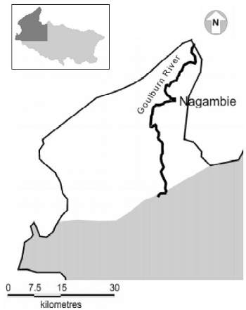
Figure 7: The Goulburn River between Seymour and Nagambie.
In this section between Seymour and Nagambie, the Goulburn River is undergoing transition to its plain tract. The gradient and velocities decrease as the river flows through a less restrictive floodplain and comes under the influence of the Goulburn Weir. The stream becomes depositional, and silt, clay and fine particles begin to dominate the substrate. Although some rocks and rock bars are present, they are less common in this section.
The river is incised into a very wide mostly cleared floodplain. Riparian vegetation is present along both banks and is dominated by willows. The riparian zone is generally wider on the low banks of the stream and the adjacent lagoons and billabongs where flooding is likely. Large woody debris is present instream along the banks and sometimes in the main channel. However, extensive desnagging has occurred to facilitate small boat navigation upstream of Lake Nagambie.
Aquatic vegetation is present where the waters are under the influence of the weir and the river height remains relatively constant.
2.6.2 Water management
Water management in the Goulburn River between Seymour and Lake Nagambie differs little from the Eildon Pondage to Seymour section. Water transfer to Goulburn Weir remains the primary management function, with private extraction from the waterway also continuing.
The presence of wetlands and billabongs along the section has little impact on water management. The wetlands are usually filled during the first series of increased flows after winter.
2.6.3 Environmental issues
Environmental issues include:
- the thermal regime of the river and its effect on the fishery (native fish);
- the predominance of willows in riparian vegetation and subsequent impacts on instream habitat/food chain; and
- the impacts of the extensive de-snagging upstream of Lake Nagambie.
2.6.4 Access and facilities
Boating is the main form of access other than a few road crossings and private property. Basic boat launching facilities are present at Majors Creek and Chinamans Bridge.
2.6.5 Current fishery
The river in this area contains redfin to about 1.5 kg, some good brown trout and a few Murray cod. Golden perch, bony bream, catfish, tench, carp and goldfish have been recorded and freshwater spiny crayfish are also sought. The current status of some of these species in the main river, particularly catfish and bony bream, is not known. Catfish have also been recorded in the Tabilk Lagoon (see off stream wetlands and billabongs). The best fishing is generally in early summer.
Trout are sought after, but numbers decrease from Seymour. Murray cod are present and targeted by some anglers but numbers appear small. Best cod fishing occurs in summer when the backwaters warm up.
2.6.6 Specific objectives and fishery management strategies
The objective of the fishery in the Goulburn River between Seymour and Nagambie is to:
develop a mixed species fishery for trout, and a restored Murray cod, golden perch, redfin and freshwater spiny crayfish population.
The fisheries management objectives for the Goulburn River between Seymour and Nagambie are to:
- determine the fishery potential of this reach;
- enhance angling opportunities for native species;
- maintain the trout population;
- encourage the taking of redfin and carp;
- maximise natural recruitment to native fish populations and residency of adult native fish in this part of the Goulburn system;
- restore the freshwater spiny crayfish population; l protect populations of Macquarie perch;
- protect and, where possible, restore stream habitats, including physical structure, riparian vegetation, water quality and flows; and
- minimise the impacts and reduce the numbers of carp.
The impediments to achieving these goals are:
- high summer flows at low temperatures not suitable to native fish;
- low winter flows;
- apparent escapement of stocked native fish (into the Waranga Basin/channel system);
- habitat/water conditions which evidently do not support large populations of native fish or brown and rainbow trout;
- the decline in numbers of freshwater spiny crayfish, probably linked to a decline in habitat quality; and
- restricted access for both bank and boatbased anglers.
The management strategies to meet the fisheries management objectives and address the issues listed include:
- maintaining a daily bag limit of trout;
- maintaining a winter closed season for trout;
- maintaining the State-wide size, catch and season restrictions for Murray cod;
- undertaking studies to determine limiting factors for the fish species in this reach;
- encouraging the taking of carp;
- actively encouraging fishing activities and management programs aimed at controlling the impacts of carp;
- assessing freshwater spiny crayfish populations and reviewing regulations to ensure effective conservation;
- identifying and defining public access points and improving angler access opportunities through signage and development of land holder relations
- actively encouraging anglers to recognise Macquarie perch and avoid harming these and other threatened aquatic species;
- enhancing opportunities for golden perch and Murray cod fisheries; and
- working in conjunction with the Catchment Management Authority waterways program and seeking other assistance to restore priority habitats that will benefit the long-term management of the fishery.
For further information refer to Part 3, Action Plan Research and Performance Indicators
2.7 Goulburn River Tributary Streams – Seymour to Nagambie
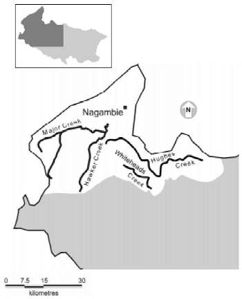
Figure 8: The major tributaries of the Goulburn River between Seymour and Nagambie.
The tributaries of the Goulburn River in the area from Seymour to Nagambie (Figure 8) rise in a drier part of the catchment and therefore have lower flows than the streams higher in the catchment. These streams have generally warm summer water temperatures and often cease to flow at these times. The streams do not support a lot of fishing with the exception of Hughes Creek.
Land use is principally dryland agriculture including grazing and cropping. The townships of Seymour and Nagambie are the largest regional centres in this area.
2.7.1 Geomorphology
A. Major Creek
Major Creek to the west is a small, often dry, watercourse. The main tributary stream is Hawker Creek. Both creeks flow through low hills where although some State Forest remains, the catchment has generally been cleared. The substrate is rock, clay and pebbles. The lower reaches of the stream are a series of long pools with shallower areas between.
Native riparian vegetation is generally continuous along the banks and some aquatic vegetation is present where water is more permanent. Instream habitat is present in the form of woody debris.
B. Whiteheads Creek
Whiteheads Creek is sourced in the granite highlands to the east. It is small and often dries out due to low summer flows. The catchment is cleared, and riparian vegetation is generally discontinuous and patchy along the stream.
C. Hughes Creek
Hughes Creek also has its source in the granite highlands to the east. It is relatively large compared to the other creeks in this section. Hughes Creek flows through the plateau of the highlands before rapidly descending through a gorge to the Goulburn plains at Avenel. The Hughes Creek catchment has been extensively cleared and land use is generally sheep grazing and viticulture.
In the extreme upper reaches, the stream flows over granite boulders and the gradient is steep. The stream has a number of deep plunge pools and shallow rapids. On the plateau proper, the gradient lowers and the stream flows through a broad valley. The granitic soils of the upper catchment are prone to erosion and the stream carries an enormous amount of sand in the riverbed, which has filled in many of the deeper areas. Consequently, the stream morphology is broad and shallow with an unbroken flow. Deeper areas are present where granite bedrock is found in the streambed and flow has washed out sand around the base.
Riparian vegetation is generally poor, although there are some patches of remnant native vegetation present, particularly near Kulaba Station. As the stream traverses the gorge, granite boulders again cause plunge pools and rapids. Downstream of the gorge some rock and pebble substrate is present in areas of faster stream velocities, but generally the flows are slow and sand dominates the substrate.
Downstream of Avenel, the lower reaches of the stream have a more diverse substrate of sand and clay. Instream woody debris is present and creates hydraulic diversity. Riparian vegetation is also more prevalent in this area, particularly downstream of the Hume Highway.
2.7.2 Water management
The major tributaries to the Goulburn River downstream of Seymour are Whiteheads Creek, Hughes Creek and Major Creek. None of these tributaries are regulated for water supply, but they provide water for irrigation and for domestic and stock use.
2.7.3 Environmental issues
Environmental issues include:
- erosion and siltation in the catchment;
- development of farm dams and resultant effects on stream flow;
- narrow (or absent) riparian buffer zones;
- remnant trout cod and Macquarie perch populations; and
- the importance of these tributaries for small native fish such as blackfish, galaxiids and pygmy perch.
2.7.4 Access and facilities
Access to Whiteheads Creek and the Major Creek system is at road crossings or through private property. Some parts of Major Creek and its tributaries also flow through areas of State Forest.
The upper reaches of Hughes Creek can be accessed near Tarcombe, at the road bridge at Bungle Boori, at the DNRE camping reserve near Bungle Boori and at some picnic sites along Hughes Creek Road upstream of Kulaba Station. The mid-reaches can be accessed at Avenel or via the Tarcombe-Avenel Road at the scout camp and at a small stream gauging weir. Downstream of the gauging weir, access is limited to private property and the Hume Highway Bridge.
2.7.5 Current fishery
With the exception of parts of Hughes Creek, streams in this area are not highly regarded as fisheries. Hughes Creek rises in hilly granite country. The large pools in this region are believed to contain a self-sustaining population of brown trout to that may weigh up to approximately 1.2 kg, presenting good opportunities for recreational angling. This area is a favoured area for fly fishers and general anglers alike.
The lower reaches off the Highlands plateau are in open plains country. Sedimentation has been found to be a major problem in this area, with large populations of carp, redfin and goldfish are present in this area.
Macquarie perch are present in the stream and were targeted by recreational anglers until they were protected in 1998. The status of the Macquarie perch population is not known. Trout cod were stocked into the reaches of the stream around Bungle Boori in the early 1990s but the current status of the population is also unknown. Stocking of native fish in Hughes Creek is not considered an appropriate management strategy in the current absence of suitable habitat
2.7.6 Specific objectives and fishery management strategies
The specific fisheries management objectives for the Goulburn River tributary streams between Seymour and Nagambie are to:
- protect populations of Macquarie perch and trout cod;
- protect and, where possible, restore populations of Macquarie perch and trout cod;
- protect and, where possible, restore stream habitats, including physical structure, riparian vegetation, water quality and flows;
- minimise the impacts and reduce numbers of carp; and
- encourage the taking of redfin and carp.
The impediments to achieving these goals are:
- low or ephemeral water flows; and
- siltation and habitat degradation in many streams.
The management strategies to meet the fisheries management objectives and address the issues listed include:
- maintaining existing fishery management strategies;
- encouraging the taking of carp;
- actively encouraging fishing activities and management programs aimed at controlling the impacts of carp;
- assessing freshwater spiny crayfish populations and reviewing regulations to ensure effective conservation;
- identifying and defining public access points, and improving angler access opportunities through signage and development of land holder relations;
- actively encouraging anglers to recognise Macquarie perch and trout cod, and to avoid harming these and other threatened aquatic species; and
- working in conjunction with the Catchment Management Authority waterways program and seeking other assistance to restore priority habitats that will benefit the long-term management of the fishery
For further information refer to Part 3, Action Plan Research and Performance Indicators
2.8 Nagambie Lakes
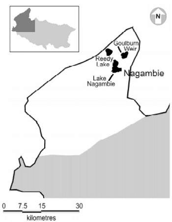
Figure 9: The location of Lake Nagambie within the Goulburn catchment.
The township of Nagambie (population est. 1,500) which borders the lake is situated 123 km north of Melbourne on the Goulburn Valley Highway. The lake (Figure 9) is a very popular tourist destination and is used for water skiing and canoeing as well as recreational fishing. There is also a rowing course on the lake.
Lake Nagambie is generally a shallow water storage, developed in the early 1890s as the first major attempt to regulate water for irrigation in Northern Victoria. Water in the lake is regulated through the Goulburn Weir, which diverts water from the Goulburn River to channels that carry water eastwards to irrigation areas around Shepparton and westwards to the Mallee region via the Waranga Basin.
The lake covers an area of 1,120 Ha and has a capacity of 25,000 ML. It is mostly surrounded by open grazing land.
2.8.1 Geomorphology
The creation of the Goulburn Weir impounded the Goulburn River, and flooded the old river course and adjacent lagoons and billabongs. he result is a storage, although often described as shallow, that has a highly variable depth depending on where the lagoons and old river channels occur. As much of the land was not cleared before the weir was formed, Lake Nagambie is dominated by a large amount of standing dead timber. Submerged large woody debris is also prolific in the storage. Littoral vegetation is profuse. Substrate is soft silt and mud with some harder clay areas.
2.8.2 Water management
Goulburn Weir creates two major pools connected by the former river course. For the purposes of this document, the entire water body is considered to be Lake Nagambie however, the northern pool is commonly referred to as Goulburn Weir while the southern pool is often referred to as Lake Nagambie. Water detained by the weir is diverted to the East Goulburn Main Channel and the Stuart Murray and Cattanach Canals. The East Goulburn Main Channel supplies the Shepparton Irrigation Area while the Stuart Murray and Cattanach Canals supply water to the Waranga Basin in the north. The East Goulburn Main Channel and the Stuart Murray Canal are diverted from near the weir structure, while the Cattanach Canal off-take is located to the south west.
The Production Management Unit of Goulburn-Murray Water has the prime responsibility for determining the levels of releases from Lake Nagambie. These releases are governed by a number of factors including:
- the level of current demand;
- the standing volume of the Waranga Basin;
- the maintenance of minimal flow requirements;
- the amount of inflow from tributaries; and l seasonal and ambient weather conditions.
Water levels in Lake Nagambie are maintained at the full supply level of Goulburn Weir during the irrigation season, which commences on 15 August and finishes on 15 May annually. A constant water level during the irrigation season is achieved by regulation of the distribution channels, with the Cattanach Canal being heavily regulated. Before 1980, the channels were usually drawn down during the winter non-irrigation season to permit maintenance on the irrigation distribution system. From 1980 to 1993, the weir level was lowered by at least 1 m to permit rehabilitation of the Goulburn Weir structure. At this time bulkheads were installed on the weir structure and on all of the outlet channel structures, hence there is no longer any requirement to lower the lake level for structure maintenance works.
In 1986 and 1996 the weir level was lowered by 3 m in the off season and since 1980 it has been lowered by 1 m annually with the exception of 1993, 1994 and 1995. Water level manipulation during this period has been used in an attempt to control aquatic weeds. The lowering of the lake by 1 m releases 10,000 ML, which represents 40% of the total lake volume.
2.8.3 Environmental issues Environmental issues include:
- the effect of the thermal regime on aquatic habitat in the lake, for example, the filling of deeper sections of the lake with cold water during summer irrigation flows;
- the impact of low winter water levels on the habitat in the lake;
- the impact of the winter drawdown for operational management on fish habitat and the aquatic ecosystem in general; l the impact of lake drawdown on aquatic vegetation and the proliferation of exotic plant species;
- the declining population of freshwater spiny crayfish in the lake - it is uncertain whether this is due to habitat degradation, overfishing or a combination of both;
- the impact of the accumulated silt and the resulting shallowness of the lake on the fishery; and
- the environmental impact of the annual use of herbicides to control aquatic weeds.
2.8.4 Access and facilities
Angler access is a problem within LakeNagambie as the majority of the land bordering the lake is private property. There are four boat ramps within the lake, only one of which is open to the public. This ramp requires a permit to launch from the local council. The availability and ease of access to a particular fishery is an important determinant of angler participation.
2.8.5 Current fishery
Historically until the early 1980s, Lake Nagambie was regarded as a notable redfin, golden perch and freshwater spiny crayfish fishery. Today the abundance of such species has declined to levels that substantially reduce the attractiveness of the lake to recreational anglers.
Prior to the decline in fish abundance in the lake, anglers could expect to catch a reasonable variety of fish species. Captures of river blackfish, catfish and Murray cod were frequent although redfin and golden perch dominated. More recently, captures of species other than carp, redfin and golden perch seldom occur.
The size of catchable fish in Lake Nagambie has also decreased. In the past, catches of redfin over 1.5 kg were common. However, the present size of redfin is now usually less than 800g.
In the past, the lake was extensively stocked with native fish species, reflecting the popularity of the fishery. From 1979 to 1986 the Nagambie Angling Club stocked the lake with 38,000 golden perch, 5,000 silver perch and 2,000 Murray cod fingerlings. From 1986 to 1994 Fisheries Victoria stocked over 400,000 golden perch fingerlings. Since 1994 there has been no stocking of fish in Lake Nagambie.
The decline in the fishery in Lake Nagambie has coincided with the annual lowering of the water levels by one or more metres most winters since 1980. Simultaneously, there has been a substantial decline in native aquatic plants in the lake, particularly ribbon weed and pipe reed. At the same time water lilies have taken over large areas previously covered by native plants. An extensive control program for water lilies has been undertaken by Goulburn-Murray Water using herbicides.
Fish populations have declined through the 1990s to levels that have discouraged fishers from frequenting the lake. Freshwater crayfish numbers have also declined in the lake. Reports from anglers indicate that catches of catfish and Murray cod have also declined.
2.8.6 Specific objectives and fishery management strategies
The fishery goals in Nagambie Lake and Goulburn Weir focus on:
restoring the mixed-species fishery for golden perch, Murray cod, redfin and freshwater spiny crayfish.
The impacts of lowering the water level in Lake Nagambie in winter and the presence of exotic aquatic plants coincide with the decline in the fishery. In addition, siltation may have resulted in a build-up of mud substrate, which may not suit native fish. Before any real improvement can be expected to this fishery, the critical limiting factors must be identified and addressed. Noting the above, the specific fisheries management objectives for Nagambie Lake are to:
- restore critical fish habitat;
- ensure effective conservation of freshwater spiny crayfish; and
- minimise the impacts and reduce the numbers of carp.
The impediments to achieving these goals are:
- water management practices;
- the condition of lake habitat and water quality; and
- possible migration of stocked fish.
The management strategies to meet the fisheries management objectives and address the issues listed include:
- maintaining existing fishery management strategies;
- encouraging the taking of carp;actively encouraging fishing activities and management programs aimed at controlling the impacts of carp;
- assessing critical habitat limitations on fisheries for redfin and native fish, especially the impacts of winter drawdown;
- assessing freshwater spiny crayfish populations and reviewing regulations to ensure effective conservation;
- identifying and defining public access points and improving angler access opportunities through signage and development of land holder relations;
- working in conjunction with the Catchment Management Authority waterways program and seeking other assistance to restore priority habitats that will benefit the long-term management of the fishery;
- assessing the need to prevent the escape of fish from the lake by the use of physical barriers; and
- evaluating the desirability and effectiveness of a fish ladder for the Goulburn Weir.
Stocking of native fish does not appear to be an appropriate management strategy at the present time. Experience has shown stocked fish do not remain in the lake. The absence of golden perch in the lake and the regular catches of golden perch reported by anglers from the connected irrigation channels suggest that the stocked golden perch may move out of the Goulburn Weir.
For further information refer to Part 3, Action Plan Research and Performance Indicators.
2.9 Offstream Wetlands and Billabongs
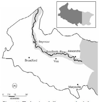
Figure 10: The location of off stream wetlands from Eildon to Nagambie.
Downstream of the Eildon Pondage (Figure 10) the Goulburn River is typical of the lowland rivers of the Murray-Darling Basin. An extensive meander belt is associated with this floodplain. The cut-off meanders have formed many oxbow lakes, swamps and billabongs along the river downstream to Nagambie. Some of these waterbodies are quite large, being up to several kilometres in length. Some hold water permanently while others are ephemeral and dry in summer. Such systems are important to the overall ecological processes of a natural river ecosystem and can provide habitat, food and nutrients to the main river.
These waterbodies are typically lined with some remnant vegetation (usually redgums) and sedges are often associated with the littoral zone. Aquatic plants are often present in the shallower areas. Typically the substrate of these lagoons is clay and silt with woody debris and
leaf litter often present. The relationship with the main channel varies for each lagoon and can vary from permanent connection to the main channel (such as the lower end of the breakaway near Alexandra), to a separate catchment (such as Sheepwash Lagoon near Molesworth). In addition, the construction
of roads on the floodplain has created artificial 'levees' which cut natural connecting channels with the Goulburn River, alienating many wetlands from the 'parent' river-channel.
These floodplain wetlands are of high value for their resident fauna, and they contain a large area of habitat for aquatic flora and fauna such as water plants, waterbirds, fish and invertebrates.
2.9.1 Geomorphology
The meandering channel of the Goulburn River has left a series of river cut-offs and former channels across the loodplain. These periodically fill to create wetlands and lagoons.
2.9.2 Water management
There is provision in the water management strategy to ensure that the off channel wetlands along the Goulburn River are replenished at reasonable intervals.
2.9.3 Environmental issues Environmental issues include:
- the unknown status of fish populations in this zone;
- watering strategies for the wetlands; and
- maintenance of riparian vegetation.
2.9.4 Access and facilities
Some public access is available at selected wetlands such as Sheepwash Lagoon, the wetlands in Yea township, Homewood Game refuge and Horseshoe Lagoon faunal reserve. Generally most of the wetlands are on private property.
2.9.5 Current fishery
The off channel wetlands offer limited angling for species such as redfin, carp and tench. Some of these areas offer potential for small water fisheries for species such as golden perch and Murray cod.
2.9.6 Specific objectives and fishery management strategies
The fishery goals for the off channel wetlands focus on:
restoring connection of the wetlands to the main channel and the development of small scale native fisheries in areas with suitable public access.
The main potential for recreational fisheries in these waters probably lies in development of:
- stocking-based fisheries for golden perch and Murray cod in large accessible and permanently isolated wetlands that do not contain threatened species;
- improved access to waters on public land;
- privately managed fishing in waters on private land; and
- restoring the connection between off stream wetlands and the main river channel.
Aside from managing the recreational fisheries in these waters, the main management priority is the protection of relict populations of native fish.
For further information refer to Part 3, Action Plan Research and Performance Indicators
Part 3
Action Plan, Research & Performance Indicators
3.1 Action Plan
Management objectives, and strategies to achieve these objectives for the separate regions of the GERFMP area, are outlined above. The major actions to be undertaken to implement the GERFMP are now summarised below, indicating the main agencies or groups responsible. These actions are additional to the ongoing trout and native fish stocking programs and the continued administration of the fisheries regulations applying to these inland waters. Priority research and assessment needs are described separately (see section 3.2).
3.1.1 Special management waters/arrangements
A. The GERFMP recognises the changing attitudes of many recreational trout anglers and the rise in the number of anglers who wish to fish primarily for sport. A concern of these anglers is that catch-rates decline over the course of the season in the more popular and accessible streams due to angler harvest early in the season.
Action: Undertake research to assess the reported decline in angler catch rates throughout the season and introduce appropriate management arrangements. Undertake a concurrent education and monitoring program to determine usage, catch rates and angler attitudes.
Responsible party: DNRE (Fisheries Victoria)
B. Fisheries Victoria currently base management of the trout fisheries in many of the streams in the GERFMP area on naturally reproducing, wild trout populations. Anglers are also supportive of wild trout fisheries.
Action: Develop feasibility plans of adaptive management strategies for stream trout fisheries.
Responsible party: DNRE (Fisheries Victoria)
C. Some streams in the GERFMP area contain endangered or threatened species. The GERFMP recognises and supports conservation efforts of such species, and does not encourage nor support practices that will further negatively impact on these species.
Action: Manage recreational fishing for minimal impact on endangered species, and support management of endangered and threatened species to ensure their sustainability.
Responsible party: DNRE (Fisheries Victoria/Parks, Flora and Fauna)
D. Some streams in the GERFMP area contain naturally reproducing wild populations of native species. The GERFMP recognises and supports conservation efforts to ensure their sustainability by lessening the impact of recreational fishing on such species, and does not encourage nor support practices that will further negatively impact on these species.
Action 1: Manage recreational fishing for the continued sustainability of naturally reproducing wild native fish species targeted by anglers.
Responsible party: DNRE (Fisheries Victoria/Parks, Flora and Fauna)
Action 2: Review recreational fishing management for Murray crayfish in collaboration with Parks, Flora and Fauna.
Responsible party: DNRE (Fisheries Victoria/Parks, Flora and Fauna)
3.1.2 Enforcement
Anglers strongly and absolutely expressed the need for more enforcement of fisheries regulations in the GERFMP area. The Steering Committee notes that a parliamentary inquiry into this aspect of fisheries management is underway at this time and that individual members have made representations to that inquiry supporting the need for more enforcement.
Action: Review current fisheries enforcement operating arrangements in accordance with the outcomes of the parliamentary inquiry that will address this specific issue.
Responsible party: DNRE (Fisheries Victoria and Regional Services)
3.1.3 Bag and size limits and salmonid regulations review
Bag and size limits are management tools imposed to achieve specific management outcomes. Common uses of these regulations are in fisheries where angling pressure is affecting the fishery and some modification of this pressure will be reflected in the fishery. Some of the reasons for imposing these regulations are:
- to spread access to the fishery resources across many users; to modify the size of fish in the fishery; to limit an individual's daily take to what most recreational fishers consider to be reasonable for personal use;
- to protect size classes or species of the fishery from over harvest; and to alter catch rates (not necessarily take rates).
Following an extensive review and public consultation process, from August 2001 Fisheries Victoria will implement bag and legal minimum size limit regulations for:
- golden perch, to spread access to the resource across users; and
- river blackfish, allowing for liberal catches of this species to encourage anglers to focus on a currently under utilised fishery. Measures introduced in July 2000, under the Flora and Fauna Guarantee Act 1988 have:
- prohibited the taking of Macquarie perch throughout the Goulburn River basin to protect this threatened species; and l tightened restrictions on taking Murray cod and catfish to protect these threatened species.
Action 1: Implement reviewed bag and size limits.
Responsible party: DNRE (Fisheries Victoria)
Action 2: Review trout bag and size limits in response to the specific objectives of the GERFMP and if necessary implement revised bag and size limits for trout.
Responsible party: DNRE (Fisheries Victoria)
3.1.4 Carp control
The Marine and Freshwater Resources Institute will continue with the current carp research program, which is aimed at describing carp population biology and characteristics which is necessary for future carp control strategies in Lake Eildon (and elsewhere in Victoria). This 3-year program is scheduled for completion in 2001. Following the release of the National Management Strategy on Carp Control in October 2000, Fisheries Victoria will lead the development of a State-wide carp control program for the catchments covered in the GERFMP in alignment with the National carp management strategy.
Action: Develop a carp control program for the catchments covered in the GERFMP in alignment with the National Carp Management Strategy
Responsible party: DNRE (Fisheries Victoria)
3.1.5 Fish habitat
Fish habitat is crucial to productive fisheries. Every attempt should be made to maintainand enhance fish habitat in the GERFMP area. DNRE (Fisheries Victoria and Regional Services) will work with the Goulburn-Broken Catchment Management Authority, GoulburnMurray Water, local government, and angler, community and industry groups to improve:
- water quality (including nutrient and sediment abatement);
- and riparian and instream physical habitat.
Action: Investigate possibilities to maintain and enhance fish habitat in the GERFMP area.
Responsible party: DNRE (Fisheries Victoria and Regional Services), Goulburn-Broken Catchment Management Authority.
3.1.6 Angler access
Access is a major issue for recreational anglers. While many access areas are available, there is much scope to open up more access locations through consultation with landholders and re-opening gazetted roads. Scope also may exist to develop access along the old SeymourAlexandra railway line. DNRE (Fisheries Victoria and Regional Services) will work with the Goulburn-Broken Catchment Management Authority, GoulburnMurray Water, local government, and angler, community and industry groups to improve:
- angler access to the Goulburn River and tributaries to Seymour for both boat and bank anglers; and
- legal access for boat launching when Lake Eildon is at low water levels.
Action 1: Investigate possibilities to increase angler access. An angler access project for the Goulburn River upstream of Alexandra is currently underway.
Action 2: Promote angler awareness of the need to obtain landowner permission prior to entering freehold land. Responsible party: DNRE (Fisheries Victoria and Regional Services), Goulburn Broken Catchment Management Authority, local
councils, Goulburn-Murray Water.
3.1.7 Eildon Pondage water levels
The DNRE Northern Region, MAFRI, local anglers and business representatives will work with Goulburn-Murray Water and Southern Hydro to ensure maintenance of adequate continuous water levels in the Eildon Pondage for the maximum period possible each year.
Action: Review operating procedures of the Eildon pondage with a view to providing adequate continuous water levels for the maximum period possible each year.
Responsible party: DNRE (MAFRI and Regional Services), local anglers and business representatives, Goulburn-Murray Water, Southern Hydro
3.1.8 Development of new fisheries
Scope exists in the catchment to increase angling opportunities. Ideas such as the development of small scale native fish waters in places such as Sheepwash Lagoon, or stocking programs for the development of native fisheries in some streams such as the Yea River or Sunday Creek, need to be explored.
Action: Develop new fisheries in the GERFMP area.
Responsible party: DNRE (Fisheries Victoria)
3.1.9 Fish escaping from fish farms
DNRE (Fisheries Victoria and Regional Services) will work with trout and salmon growers with a view to minimising escapes of fish into the Goulburn River and its tributaries.
Action: Investigate the feasibility of incorporating fish escape minimisation as a condition of aquaculture permits.
Responsible party: DNRE (Fisheries Victoria)
3.1.10 Water management
DNRE (Fisheries Victoria and Regional Services), in consultation with the GoulburnBroken Catchment Management Authority, Goulburn-Murray Water, local anglers and business representatives will pursue a review of the Bulk Water Allocation for the Goulburn River for an appropriate environmental flow allocation, including Goulburn Weir.
Action 1: Review the environmental flow allocations and delivery process for the Goulburn River
Action 2: Review the operating procedures of Goulburn Weir with a view to optimising water levels for the protection of the aquatic ecosystem.
Responsible party: DNRE (Fisheries Victoria and Regional Services), Goulburn-Broken Catchment Management Authority, GoulburnMurray Water
3.1.11 Recreational fisheries promotion
Promoting an understanding of the many factors that impact on our fisheries is an important role for Fisheries Victoria. It is equally as important to communicate what is being done as it is to explain clearly what the impediments to improving our fisheries are. Information, which assists anglers to gain the maximum from their angling experience, is also required. Much scope currently exists to promote recreational fisheries in the area via access point signage, improving land holder/angler relations and improved access.
Action: Produce educational material such as access maps and 'how to fish' guides for the GERFMP area.
Responsible party: DNRE (Fisheries Victoria - Education & Information)
3.2 Research Priorities
The fisheries in the GERFMP area are complex and dynamic. They can fluctuate considerably as a result of an interconnected range of climatic, environmental and human factors. The need for fisheries management to incorporate the results of scientific research into its decision-making processes is well recognised.
The main recreational fishing issues identified in the GERFMP center on some common areas: primarily the population status of angling species, and the improvement of these stocks and of the fisheries based on them. At present, there exist several essential knowledge gaps that are impediments to selecting the right management tools to tackle many of these issues. These gaps reflect the concerns of anglers. The following strategic research priorities are specifically aimed at key issues across the GERFMP area as determined through the public consultation process. These research priorities are:
- Assess intra-seasonal variation in trout populations to determine the necessity to further control harvest
- Eildon to Seymour tributary streams
- Upper tributaries of Lake Eildon.
- Monitor trout populations to determine population size
- Goulburn River
- Lake Eildon brown trout.
- Quantify fisheries performance through creel surveys and angler diaries
- Upper tributaries of Lake Eildon
- Eildon - Seymour tributary streams
- Goulburn River
- Lake Eildon
- Eildon Pondage (include cost benefit analysis of stocking).
- Establish indices of trout recruitment as long-term indicators of recruitment levels and assess impacts of flow variations on recruitment where applicable
- Upper tributaries of Lake Eildon
- Eildon - Seymour tributary streams
- Goulburn River.
- Assess the fisheries decline in Lake Nagambie and develop a strategy for fishery rehabilitation.
- Assess the golden perch fishery in Lake Eildon. Assess the freshwater crayfish fishery throughout Plan area and develop a management strategy.
- Assess the status of Macquarie perch and trout cod within the GERFMP area.
- Assess the impacts of flow regimes on spawning trout in the Goulburn River and fish populations in the Goulburn River
- Assess opportunities for aquatic and riparian habitat enhancement
- Tributary streams
- Goulburn River
- Lake Eildon.
- Determine angler usage patterns in high use areas.
- Develop a program for the improvement of access, including signage.
Many of these issues are closely linked and a comprehensive research program would incorporate a number of topics. Conversely, it may be necessary to undertake several studies to develop a full picture of a fishery such as the Goulburn River. It is therefore difficult to determine a strict order of priority. In general terms the Committee determined the following order of priority recognising that some elements from each section may be included in one project.
- Goulburn River and tributary streams
- Lake Nagambie fishery
- Fisheries of Lake Eildon and tributary streams
- Aquatic and riparian habitat studies/ fisheries access
- Native fish
3.3 Performance Measurement
Stakeholders' responses have been used to verify, amend or replace the angler goals, fisheries management objectives, strategies and actions set out in the discussion paper.
Following the consultation process necessary to achieve this feedback, the acceptance of these elements by all stakeholders is the crucial element of the GERFMP.
As required under the Fisheries Act 1995, the final GERFMP must specify performance measures, targets and monitoring methods for each of the key fisheries management objectives, addressing the biological, social and economic dimensions of these fisheries. This performance measurement framework will enable the impact of the GERFMP to be tracked and those responsible for mplementing it to be held accountable.
The following matrix sets out the performance measures, targets and actions of the GERFMP. Current status and end/review dates have been added. It is expected that a review of the GERFMP will be undertaken in 2005. At this point the actions will be reviewed for completeness and new actions formulated.
3.4 Stakeholder Consultation & Responses
The development of the GERFMP was carried out with involvement and input sought from all major stakeholders including DNRE (Fisheries Victoria and Regional Services), Goulburn-Murray Water, the Victorian Recreational Fishing Peak Body (VRFish), local angler groups, conservation interests, Aboriginal interests, catchment and water managers, local government, and tourist and business interests.
An essential part of the preparation of the GERFMP involved stakeholder comment on specific issues related to the fishery. A letter requesting written submissions outlining the intentions of the GERFMP and the need for public comment was developed and approved through consultation with the steering committee. A copy of this letter is reproduced in Section 4.2.
Sixty-one letters were sent on 10 December 1999. A list of respondents has been provided in Section 4.3.
Four public meetings were also conducted in the GERFMP area (Mansfield, Eildon, Seymour and Nagambie) to receive comments on the discussion paper. Calls for public submissions were also published on the DNRE web site, through pamphlets distributed around stores, information centres and tackle outlets throughout the upper Goulburn catchment, and through articles released to the press for publication in newspapers. All submissions received were collated and presented to the Steering Committee for consideration
| Objective |
Performance Measure | Target |
Monitoring Method | ||
|---|---|---|---|---|---|
| Biological | Social | Economic | |||
| 1. Provide a wide variety of fishing experiences with year-round fishing opportunities for both native and introduced species | a. % of anglers who are moderately to highly satisfied with their day's fishing b. % of anglers who caught ≥ 1 fish of each species they targeted on day of interview c. Angler catch rate d. Completion of feasibility study for adaptive trout management e. Completion and implementation of Salmonid Regulations Review and Golden Perch bag and size limits | a. >60% in mid 2002 >70% in mid 2003 b. >40% in 2002 >50% in 2003 c. 0.2 takeable fish/hour in recognised trout streams d.Completed by December 2002 e. Start September 2001 | a. Creel surveys and Fisheries Officer interviews b. Creel surveys and Fisheries Officer interviews c. Creel surveys and Fisheries Officer interviews d. Annual report to FCC and Minister Regulations widely publicised | ||
| 2. Manage with a view to developing the fisheries to their full sustainable potential | a. Production and distribution of promotional information on fishing opportunities b. % of tourists who are aware of the fishing opportunities | a. Trend over time b. > 25% by mid 2002 | a. Annual report to FCC and Minister b. Tourism Surveys | ||
| 3. Provide for improvements to fish ihabitats, in relation both to a wide range of threatening processes and to the opportunities for improved production or access to target fish species | a. Completion of identified research priorities b. Catchment and water managers' strategic and operational plans | a. All projects fully funded or scheduled for funding by specified dates b. Habitat improvements incorporated in all plans | a. Annual report to FCC and Minister | ||
| 4. Provide for the conservation and enhancement of recreational fishing target species and other freshwater fauna within the system | a. Development and implementation of Carp Controls b. Demonstrable effectiveness of controls on fish escapement from fish farms c. Maintenance and support of FFG listing of threatened species d.Completion and implementation of Salmonid Regulations Review | a. Carp control measures and community education programs in place b. Fish farm escapes eliminated c. >70% of anglers aware of threatened species and able to identify them d.Regulations publicised by 1 September 2001 | a. Annual report to FCC and Minister b. Angler reports and MAFRI surveys c. Angler surveys and Fisheries Officer reports, including compliance data d.Report to Minister | ||
| 5. Involve relevant resource managers in the fisheries management process and consult/negotiate with them in relation to possible positive outcomes for the fisheries resources and fish habitats | a. Completion of review of environmental component of Goulburn Broken Bulk Water entitlement | End 2002 | Annual report to FCC and Minister | ||
| 6. Provide for the positive input of resource users in the fisheries management process for the area | a. % of anglers who are aware of the plan and opportunities for input to review processes b. % of Goulburn Valley locals who are aware of the plan and opportunities for input to review processes |
>10% >25% | Creel surveys | ||
| 7. Facilitate processes for improvement of access and facilities within the GERFMP area | Streams b. Number of easy, identifiable access pts/km c. Boat launching facilities per 5 km Lakes b. Improved boat launching facilities | a. Continuous improvement b. Continuous improvement c. 1/5 km below Seymour a. >2 with different aspects on each of Eildon Pondage, Lake Nagambie | |||
| 8. Achieve the best possible match between the fisheries management arrangements and Victorian recreational fishers' aspirations for the fisheries in these waters | a. Recreational fishers' satisfaction with the plan outcomes b. Recreational fishers' satisfaction with compliance with management arrangements | >75% by mid 2003 | Angler Surveys and Fisheries Officer reports | ||
Part 4
Further Reading & Supporting Information
AcknowledgmentsThroughout the development of the GERFMP, assistance has been sought and cooperation has been received from many people in various private and government institutions. Mr Rod Theobald (Chair) Department of Natural Goulburn-Murray Water Eildon Action Southern Hydro Partnership | FutureFish Foundation VRFish Australian Water Technology Murrindindi Shire Strathbogie Shire Goulburn Broken Catchment Management Authority Angling Clubs Fishing Tour Operators Aquaculture Operators |
4.1 Further Reading
Flora and Fauna Guarantee Act 1988, Act No. 47/1988
Fisheries Act 1995, Act No. 92/1995
Environment Protection and Biodiversity Conservation Act, Act No. 91/1999
Cadwallader, P & Lawrence, B (1990) Fish in the Murray in The Murray eds. Mackay, N.E.& Eastburn, D., Murray Darling Basin Commission (Australia), Canberra
Caldwell Connell Engineers (1978) Study of Recreation and Land Use: Lake Eildon and Environs, State Rivers and Water Supply Commission of Victoria, Melbourne, Australia
Commonwealth of Australia (1992) National Strategy for Ecologically Sustainable Development, Commonwealth Government of Australia, Canberra
Cottingham, P (1994) Development of a Nutrient Management Strategy for the Goulburn and Broken River Basins (A National Landcare Program project):Inception Report, State Water Laboratory of Victoria, Goulburn/Broken Water Quality Working Group: Report No. 113, Armadale, Australia
Cottingham, P, Amenta V, & Lidston, J (1995) The Occurrence of Algal Blooms and a Review of Nutrients in Surface Waters in the Goulburn and Broken River Basins, Water EcoScience Report No. 36/95, Mt Waverley, Australia
Environment Protection Authority (Victoria) (1988) State Environment Protection Policy, Melbourne, Australia
Goulburn-Broken Catchment Management Authority (1997) Goulburn Broken Catchment Land Protection Board, Final Catchment Strategy, Goulburn Broken Catchment Land Protection Board
Goulburn-Broken River Environment Water Quality Committee (1997) Goulburn Broken Water Quality Strategy: Addendum to Draft Strategy: Goulburn/Broken Regional Catchment Strategy, Goulburn City Council, Tatura
Kearney, R. E., Davis, K.M. and Beggs, K.E., eds. (1999) Issues affecting the sustainability of Australia's Freshwater Fisheries Resources and Identification of Research Strategies, CRC
Freshwater Ecology Project No 97/142, University of Canberra, Australia Lawrence, B. W. (1991) Fish Management Plan: Draft, Canberra, Murray-Darling Basin Commission
Murray Darling Basin Commission (1992) River Murray Boating Management: Draft Discussion Paper, Murray Darling Basin Commission (Australia), Canberra
Murrindindi Shire Council (1999) Murrindindi Magic: Visitor Director (Summer 1999/2000)
Nathan, R. J. (1992) Environmental Flows in the Goulburn River between Eildon and the Murray River, Armadale, Rural Water Commission of Victoria
Natural Resources & Environment, Dept of (1997) Heritage Rivers and Natural Catchment Areas: Draft Management Plans, Dept of Natural Resources and Environment, East Melbourne, Victoria
Natural Resources & Environment, Dept of (1997) Victoria's Biodiversity: Directions in Management, Dept of Natural Resources& Environment, East Melbourne, Victoria
Natural Resources & Environment, Dept of (2001) Victorian Recreational Fishing Guide 2001-2002, Fisheries Victoria, Melbourne, Australia
Sandercock, C. (1996) Major Storages Operational Monitoring Program Report 1992-1995, Prepared for Goulburn-Murray Water, Southern Rural Water & Wimmera-Malley Water by Water
Ecoscience, Mt Waverley, Victoria
Thomson, W. K. (1998) The Evolution of Regional Tourism in Victoria, Country Victoria Tourism Council, Melbourne, Australia
Tourism Victoria (1995) Building Tourism: Guidelines for Tourism Development in Victoria, Tourism Victoria, Melbourne, Australia
Tourism Victoria (c1997) Strategic Business Plan 1997-2001: Building Partnerships, Tourism Victoria, Melbourne, Australia
Tourism Victoria (c1997) Strategic Business Plan 1997-2001: Building Partnerships: Summary, Melbourne, Tourism Victoria: 15.
Trueman, J. W., Hoye, G.A., Hawking, J.H., Watson, J.A. & New, T.R. (1992) Hemiphlebia mirablis Selys: New Localities in Australia and Perspectives on Conservation (Zygoptera: Hemiphlebiidae) Odonatalogica 21: 367-374.
Upper Goulburn Waterways Authority (1998) Upper Goulburn Waterway Plan, Upper Goulburn Waterways Authority
Unkles, B. (1997) Economic Impact of Recreational Fishing in Victoria, Fisheries Victoria, Melbourne, Australia
Water EcoScience (1997) An Assessment of the Aquatic Vegetation of the Goulburn Weir, Report prepared for Goulburn-Murray Water by Water EcoScience, Mt Waverley, Australia
Water EcoScience (1988) Ranking GoulburnMurray Water Storages by Environmental Condition and Needs, Report prepared for Goulburn-Murray Water by Water Ecoscience, Report No. 214/98, Mt Waverley, Australia
4.2 Appendix A
Copy of the letter sent out seeking public comment:
10thDecember 1999
The Steering Committee are developing a fisheries management plan for the Goulburn River upstream of and including Lake Nagambie (Goulburn Weir), on behalf of the Department of Natural Resources and Environment. A fisheries management plan (FMP) provides a means whereby fisheries can be managed to ensure the use of the fish resources, aquaculture industries and associated aquatic biological resources are undertaken in an effective, efficient and ecologically sustainable manner. The GERFMP must be consistent with the objectives of the Fisheries Act 1995 and with the principles of the Victorian Inland Fisheries Strategy, Ecologically Sustainable Development and Conservation of Biodiversity. The GERFMP must also be developed within the statutory requirements of regulatory bodies such as Goulburn-Murray Water and the Southern Hydro Partnership. A key component of the development of the GERFMP is the identification of stakeholder issues and constraints. The preparation of the GERFMP is being overseen by a steering committee made up of relevant stakeholders including; Fisheries Victoria, VRFish, Eildon Action, Goulburn-Murray Water, Goulburn Broken Catchment Management Authority, Murrindindi Shire, Marine and Freshwater Resources Institute and Fisheries Victoria. However, AWT Victoria recognises that this committee although broadly based, does not represent the whole community. Therefore, AWT Victoria would like to take this opportunity to invite you or your organisation to comment on the following key issues and provide your thoughts on any additional points you feel relevant to the development of the GERFMP. The quality of fish habitat including water levels. Angler access. Native versus non-native fisheries. Conservation needs. Abundance versus condition of fish stocks. Sustained multiple use in the fishery. The Steering committee request that written submissions be forwarded to Anthony Conallin C/- AWT Victoria Private Bag 1 Mt Waverley 3149 by Friday the 10th of December 1999. If you have any further queries or need more information, please do not hesitate to contact the Program Leader Michael Shirley or myself on (03) 9550 1000. |
4.3 Appendix B
List of respondents of the Goulburn-Eildon Region Fisheries Management Plan questionnaire.
| Mr Russ Atkinson | Promotions Officer | Strathbogie Shire | Nagambie | Vic |
| Mr W Cubbin | Secretary | Nagambie Angling Club | Nagambie | Vic |
| Mr Wayne Fulton | Steering Committee | MAFRI (Snobs Creek) | Alexandra | Vic |
| Mr Mick Hall | Steering Committee | Eildon Action | Eildon | Vic |
| Mr Geoff Hall | Tour Operator |
Goulburn Valley Fly Fishing Centre | Thornton | Vic |
| Mr Kevin Jacka | Committee Member |
VRFish (North East Association) | Violet Town | Vic |
| Mr Lawrence Marretti | Chairman |
VRFish (North East Association) | Jindera | NSW |
Mr Gary O'Donaghu | Steering Committee | VRFish | Glen Waverley | Vic |
Mr W O'Kan | CEO | GBCMA | Shepparton | Vic |
| Mr J Pincombe | Steering Committee | Angling Guide | Mansfield | Vic |
Mr Rod Theobal |
Chair Steering Committee | Landowner | Nagambie | Vic |
| Secretary | Goulburn River Trout | Alexandra | Vic |
Appendix C
Gazetted Guidelines.