Bendigo Region - Fisheries Management Plan
Foreword
The primary purpose in managing the Bendigo Regional Inland fishery is to provide and enhance opportunities for year round angling and to ensure the long-term sustainability of the resource. Stage One of the Bendigo Region Fisheries Management Plan establishes the guidelines to achieve that purpose.
As part of the Bracks Government's commitment to effective consultation in decision making, the Fisheries Co-Management Council in consultation with the Inland Fisheries Committee has overseen the preparation of the plan.
In addition, the active contribution of the Bendigo Region Fisheries Management Plan Steering Committee has substantially shaped the plan's content by providing the focus for input from major stakeholder groups, anglers and other interested agencies. This extensive community input gives rise to my confidence that the plan will accommodate both the current and future needs of the fishery and its users.
The plan sets out the strategies and actions for managing the fishery over the next five years. In doing so it acknowledges the need to establish and strengthen partnerships between all stakeholders sharing an interest in the management of the region's fish stocks and aquatic habitats and the waterways that support them. It is part of the Bracks Government's vision for Victoria as a state where protecting the environment and using our resources sustainably is built into everything we do.
In the years to come, it is expected that management issues will change as new information about the fishery comes to light. The evolution of different attitudes and traditions within the angling community may also give rise to the need for new management initiatives. Therefore, it is important that this plan is not regarded as a static document, but rather as a dynamic mechanism that will be adapted and enhanced according to changing community requirements and increased understanding of the environmental factors affecting the fishery.
To that end, the Government will continue to invite input from stakeholders in implementing and refining the plan in the years ahead.
I take this opportunity to congratulate all those involved in the plan's development, in particular the Bendigo Region Fisheries Management Plan Steering Committee for its extensive commitment to this project.
Candy Broad
Minister for Energy and Resources
Steering Committee Members and Affiliations
| Chair: Ms Jacinta Allan M.P. Member for Bendigo East Bendigo |
Mr David Schier Goulburn-Murray Water Tatura |
| Mr Neville Fowler NRE (Fisheries Northern) Benalla |
Mr Lindsay Hamley Midland & North Central Angling Association Bendigo |
| Mr Eain McRae NRE (Fisheries Northern) Bendigo |
Mr Greg Peters North Central Catchment Management Authority Huntly |
| Mr Alan Baxter NRE (Fisheries Victoria) Box Hill |
Mr Keith Oberin City of Greater Bendigo Bendigo |
| Mr John Corbett VRFish Bendigo |
Ms Melody Jane Bendigo Region Fisheries Management Plan Project Officer Bendigo |
| Mr Bruce Duncan Coliban Water Bendigo |
How to Use This Document
This document is divided into eight parts:
- Part 1 provides an Executive Summary of the document.
- Part 2 describes the legal and planning process of the BRFMP and includes its context, background, and overall goals and objectives.
- Part 3 identifies major environment and habitat issues across the catchments, and outlines strategies and actions for future management.
- Part 4 gives a narrative overview of the major fisheries management zones in the Bendigo region, as identified through stakeholder response, and outlines the specific strategies and actions for these waters.
- Part 5 presents the actions required to implement the BRFMP.
- Part 6 identifies the research priorities for the Bendigo region's fisheries.
- Part 7 describes the performance measures of the BRFMP.
- Part 8 lists further reading and supporting information.
Abbreviations Used Throughout This Document
| BRFMP | Bendigo Region Fisheries Management Plan |
| CALP | Catchment and Land Protection Act 1994 |
| CAS | Catchment and Agricultural Services |
| CAW | Catchments and Water |
| CCWG | Campaspe Community Working Group |
| CFA | Country Fire Authority |
| CoM | Committee of Management |
| CRC | Co-operative Research Centre |
| FCC | Fisheries Co-Management Council |
| F&F | Flora and Fauna |
| FFG | Flora and Fauna Guarantee Act 1989 (Vic) |
| FFGIP | Flora and Fauna Guarantee Implementation Plan |
| FV | Fisheries Victoria |
| G-MW | Goulburn-Murray Water |
| LCWG | Loddon Community Working Group |
| LG | Local Government |
| LV | Land Victoria |
| MAFRI | Marine and Freshwater Resources Institute |
| NCCMA | North Central Catchment Management Authority |
| NRE | Department of Natural Resources and Environment |
| OCE | Office of the Commissioner for the Environment |
| PFF | Parks, Flora and Fauna |
| PV | Parks Victoria |
| RWA | Rural Water Authority |
| SRD | Sustainable Regional Development |
| VRFish | Victorian Recreational Fishing Peak Body |
| WHS | Water Health Strategy |
| WWC | Waranga Western Channel |
Table of Contents
- Part 1: Executive Summary
-
Part 2: Context, Background, and Actions of the BRFMP
- 2.1 Introduction
- 2.2 Planning Framework
- 2.3 Goals and Objectives
- 2.4 Context and Background
- 2.5 Fishes of the Region
-
Part 3: Key Management Strategies and Actions
- 3.1 Introduced Fish Species
- 3.2 Threatened or Vulnerable Native Fish Species
- 3.3 Habitat
- 3.4 Water Quality
- 3.5 Access and Facilities
- 3.6 Fisheries Compliance
- 3.7 Angler Education
- 3.8 Implementation
-
Part 4: Localised Management Zones, Strategies and Actions
- 4.1 Upper Coliban River Storages (Zone 1)
- 4.2 Lake Eppalock (Zone 2)
- 4.3 Campaspe River (Lake Eppalock - Echuca) (Zones 3A & 3B)
- 4.4 Cairn Curran Reservoir (Zone 4)
- 4.5 Jim Crow Creek (Zone 4)
- 4.6 Barkers Creek Reservoir (Zone 4)
- 4.7 Tullaroop Reservoir (Zone 5)
- 4.8 Loddon River (Laanecoorie–Bridgewater) (Zone 7)
- 4.9 Crusoe and No. 7 Reservoirs
-
Part 5: Action Plan
- 5.1 Implementation
- 5.2 Enforcement
- 5.3 Carp and Roach Control
- 5.4 Bag and Size Limits
- 5.5 Fish Habitat
- 5.6 Angler Access
- 5.7 Water Management
- 5.8 Water Level Above the Campaspe Siphon
- 5.9 Riparian Rehabilitation
- 5.10 Recreational Fisheries Promotion
- 5.11 Angler Conduct
-
Part 6: Research Needs
- 6.1 Environmental Flows for the Campaspe River
- 6.2 Lower Loddon River and Campaspe River Murray Cod Assessment
- 6.3 Upper Coliban Reservoir Macquarie Perch Assessment
- 6.4 Threatened Species Stock Assessments
- 6.5 Mercury Analysis
- 6.6 Riparian Management Strategy
- 6.7 Stocking Regimes
- Part 7: Performance
-
Part 8: Further Reading and Supporting Information
- 8.1 Further Reading
- 8.2 Appendix A
- 8.3 Appendix B
- 8.4 Appendix C
- 8.5 Appendix D
- 8.6 Appendix E
Part 1: Executive Summary
Victoria's fisheries are managed according to a framework of statewide policies and strategies. The Bendigo Region Fisheries Management Plan (BRFMP) sets out how these policies and strategies will be applied at a local level.
The BRFMP is a strategic document that clearly outlines future management directions and arrangements for fisheries in the Bendigo region.
The issues affecting fisheries in the Bendigo region were identified by the major stakeholder groups represented on the Steering Committee and through extensive consultation with anglers, other interested agencies and the wider community.
Key issues identified for the major fisheries of the Bendigo region are:
- access to the fisheries and facilities
- angler education
- carp and roach control
- FFG listed, threatened or vulnerable native fish species and communities
- fisheries compliance
- funding
- habitat, in particular water quality and quantitY
- introduced fish species
Management strategies with specific actions were developed for each issue and these have regard for other natural resources and users of the habitats concerned.
An action plan is set out in Part 5 of the BRFMP, and addresses:
- implementation
- enforcement
- carp and roach control
- bag and size limits
- fish habitat
- angler access
- water management
- water level above the Campaspe Siphon
- riparian rehabilitation
- recreational fisheries promotion
- angler conduct
All strategies and actions are designed to be consistent with the overriding mission for management of the Bendigo region fishery, and wherever possible are clearly measurable so that anglers and managers can be confident that suitable progress is being made. The Fisheries Act 1995 (Vic) states that all fisheries management plans must specify performance indicators, targets and monitoring methods. Performance measures, targets and monitoring methods for the overall Objectives of the BRFMP are outlined in Part 7 (Table 11).
The BRFMP also outlines future research requirements for the improved management of fisheries in the Bendigo region (Part 6).
- Identified research priorities include:
- environmental flow requirements for the Campaspe river;
- the status of the Macquarie perch populations in the Upper Coliban Reservoir;
- stock assessments of FFG-listed species such as trout cod and silver perch;
- analysis of the mercury levels in the major angling species taken, in particular from Tullaroop Reservoir, Lake Eppalock and Cairn Curran Reservoir; and
- the development of a riparian management strategy.
Partnerships are Essential for Delivering Outcomes
In striving for effective fisheries management, the strengthening of partnerships between all stakeholders is critical.
At a broad level, the fisheries management arrangements specified in the BRFMP will be led by NRE (Fisheries Victoria and Northern Region). The inputs to environment, biodiversity and land use plans and programs will be coordinated by NRE and the North Central CMA, and water storage management will be coordinated by Goulburn-Murray Water and Coliban Water.
An important role of all agencies will be facilitation of community involvement and information programs.
Specific projects will be developed on a collaborative basis, similar to the Recreational Fishing Licence funded 'angler access and stream habitat restoration project' being conducted in the Goulburn River by the Goulburn-Broken CMA in conjunction with NRE.
While the main direct outcomes of fisheries management plans are focused on the sustainable use and allocation of fisheries resources, the health of aquatic ecosystems is fundamental to the health of these resources. In addition, fisheries can have harmful impacts on ecosystems if not managed and conducted sensitively.
Accordingly, fisheries management plans must identify environmental issues and impediments, and the appropriate management responses.
Once identified, these issues and their importance to fish and fisheries form important inputs to a number of Victoria's natural resource planning processes.
In understanding the development of the BRFMP, a clear understanding of the relationships between Victoria's resource management frameworks involved, and of the linkages between management planning processes, are both important.
For example, fisheries management is within the Government's Energy and Resources portfolio, separate from biodiversity catchment management and water management which are within the Environment and Conservation portfolio.
Habitat and environmental planning is manifest in an integrated framework of regional catchment strategies, catchment action plans (salinity, water), river health plans, bulk water entitlements, streamflow management plans, and Victoria's Whole of Government Biodiversity Strategy. This portfolio of Conservation and Environment also includes the Flora and Fauna Guarantee Implementation Plan (FFGIP), addressing:
- Instream temperature pollution
- Flow patterns
- Sedimentation
- Removal of woody debris
- Fish passage impediments
- Threatened species actions
As an overarching framework for aquatic environmental management, Victoria is currently developing a catchment-based State River Health Strategy (SRHS) to set the directions for all the major management functions that affect the health of rivers and their associated floodplains and wetlands. The SHRS will:
- Identify environmental, recreational, cultural, social and economic assets for each major river reach, the current condition of the asset and its comparative community value.
- Identify processes threatening these values and the severity of the risk involved.
- Identify opportunities for restoration of any degraded values and the requirements for restoration.
- Set broad priorities for action.
- Identify the key specific action plan required and its overall priority (for example if flow is a threat, then a streamflow management plan may be required; if the threat is increased incidence of algal blooms, then a nutrient management strategy will be needed).
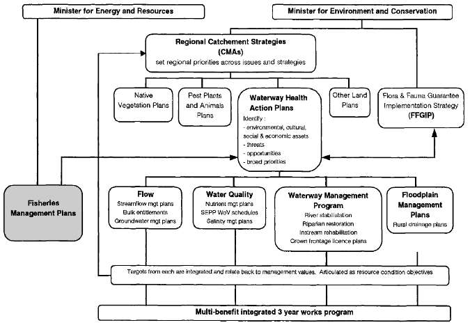
More detailed catchment based waterway health action plans (WHAPs) based on the SRHS will be developed by each CMA.
Actions under the FFGIP and the WHAPs will deliver many of the desirable fisheries outcomes identified in the BRFMP, but are separate from direct actions under the BRFMP.
The habitat and environmental issues identified in each of the issue-specific action plans, including fisheries management plans, will be integrated and articulated in each WHAP as river health objectives for major river reaches within each catchment.
A reporting program that will enable monitoring and achievement of both resource condition and implementation targets in these processes can be included in the WHAP framework to illustrate how the issues identified in the BRFMP are being addressed.
Part 2: Context, Background, and Actions of the BRFMP
2.1 Introduction
Recreational fishing is one of the most popular recreational pursuits in Victoria, with more than 800 000 Victorians participating in fishing at least once a year (Tourism Victoria, 2000). The contribution of the recreational fishing sector (including support industries) to the Victorian economy is estimated to be approximately $1.265 billion per annum; it also generates 27 000 associated jobs (Unkles, 1997).
As the Government agency responsible for this area, the role of Fisheries Victoria is to be a lead advocate for fish habitat protection in public waters and to manage recreational, commercial and traditional fisheries and commercial aquaculture in Victorian waters.
In doing so, Fisheries Victoria recognises and supports the need for protection of species listed under the Flora and Fauna Guarantee Act 1988 (Vic) (FFG Act) from the impacts of fishing and other influences.
The primary focus of the BRFMP is on the recreational fisheries of the region. Nevertheless, the BRFMP also aims to influence and assist those engaged in water and catchment management programs to improve the quality of fish habitats through their policies and actions. It also identifies the need and opportunities for improving fish habitat and controlling noxious species.
A fisheries management plan is a public document which clearly outlines future management directions and arrangements for recreational and/or commercial fishing for a given water body or species.
The overall aim of the BRFMP is to achieve the best possible match between the fisheries management arrangements of Fisheries Victoria, and the Victorian recreational fisher's aspirations for recreational fisheries in the catchments of the Campaspe River and upper Loddon River.
In doing so the BRFMP must:
- ensure that the use of the fishery resource is ecologically sustainable;
- ensure that the management of the fishery is consistent with other conservation and natural resource management aims of the Department of Natural Resources and Environment (NRE); and
- develop guidelines for the resolution of issues between user groups.
Whilst a whole of catchment approach is possible for the Campaspe River catchment, a slightly different approach has been adopted for the Loddon River catchment. This catchment is much larger and significantly more complex than the Campaspe River catchment. The adoption of a whole of catchment approach for the Loddon River Catchment can be managed more easily if a staged method is utilised.
The current management of fisheries along the Loddon River has an easily defined boundary at Fernihurst Weir. Below this structure, influences by the Torrumbarry Irrigation System begin to occur and the complexities of the Kerang Lakes area also impact on fisheries management.
The management of the Loddon River catchment has been divided into two stages:
Stage One: The whole of the Campaspe River catchment and that section of the Loddon River Catchment down to and including Fernihurst Weir.
Stage Two: The lower Loddon River catchment including the Kerang Lakes and the Torrumbarry Irrigation System.
This BRFMP encompasses Stage One of the Loddon River Catchment - from the headwaters down to and including Fernihurst Weir.
The development of the BRFMP features direct participation by Victorian recreational fishers and operates in an inclusive manner to ensure that the wider stakeholder groups are informed of progress and have every opportunity to have input into its development. The BRFMP is being led by a steering committee with strong representation from key stakeholder groups in the Bendigo region.
2.2 Planning Framework
The Fisheries Act 1995 (Vic) and fishing regulations provide the main framework for sustainable use of living aquatic resources, protection of fish habitats, promotion of sustainable quality recreational fishing opportunities, facilitation of access for a range of uses and community involvement in fisheries management.
As set out in the first objective of the Act, the overriding principle in the management of Victoria's fisheries is that they should be managed on an ecologically sustainable basis. Throughout the BRFMP, the concept of sustainability of fisheries is stated or implied and refers to the principles of Ecologically Sustainable Development as they apply to fisheries.
Part 3 of the Act sets out the legislative framework for developing inland fisheries management plans. In accord with this framework, guidelines for the development of the BRFMP were published in the Government Gazette on 12 August 1999.
Additionally, under Part 3 of the Fisheries Act 1995:
- the purpose of a fisheries management plan is to specify policies and strategies for the management of the fisheries on a sustainable basis, having regard to recreational, commercial, traditional and non-consumptive uses of the resources; and
- public authorities (such as catchment and water managers) must have regard to relevant fisheries management plans and, before taking any action that is inconsistent with a fisheries management plan, must consult with the Secretary of NRE.
Victorian Government policies on the stocking of native and salmonid fish, translocation of fish, and biodiversity conservation are also important parts of the framework for the BRFMP.
The guidelines in Part 3 of the Act describe the scope, aim, process and key features of the BRFMP. In addition to these legal requirements, the BRFMP must be structured so that key fishery attributes are described, and goals and objectives provided to guide future management.
These goals and objectives are a blend of ecological need and the aspirations of the users of the fishery. This blend forms the vision for the future of the fishery. As such, the BRFMP is jointly 'owned' by all that have an interest in the resource.
The Fisheries Co-Management Council has overseen the fisheries management planning process and has ensured that the planning process has conformed to the requirements of the Act and the guidelines published in the Government Gazette.
The appropriateness of the BRFMP's provisions and the level of success achieved will be measured by the degree to which overall and specific goals and objectives are met. It will be necessary for managers and anglers to monitor this collectively on an ongoing basis.
The purpose of the BRFMP is to identify required actions.
Part 5 of the BRFMP outlines the fisheries management tools that may be used to implement the BRFMP and may include methods outlined in the 1997 Victorian Inland Fisheries Strategy. The limitations of fish habitat and other external factors strongly influence what these tools can achieve in any water body.
VRFish, the peak body representing the interests of all Victorian recreational fishers' has also developed policies on native fish fisheries, salmonid fisheries and environmental flows.
As more information on the fishery comes to light, management requirements will change and new needs will be identified. Also, the aspirations of anglers and fishing traditions will continue to evolve and subtly change over time. For these reasons it will be necessary to review and update the BRFMP from time to time.
Fundamental factors that determine what is possible in terms of fisheries management in the region include water release practices and the water temperature regime during the irrigation season.
Such factors limit the scope for restoration of healthy native fish populations which are a threatened community and is also among a number of potentially threatening processes listed under the FFG affecting aquatic ecosystems in Victoria. (see Act listing "Lowland riverine fish community in Victorian drainage flowing north into the River Murray")
This circumstance also conflicts with the protection of beneficial uses of Victoria's public waters and the intent of the State Environment Protection Policy (Waters of Victoria) (SEPP (WoV)).
While the BRFMP recognises these impediments and threatening processes, and strongly advocates remedial action, the fisheries management strategies that follow are framed in the context of current water management arrangements.
Major changes to the aquatic environment in the future will act as triggers for reviewing the BRFMP. Examples include changes to water flows and release patterns, implementation of FFG Action Statements that address threats to aquatic ecosystems, or the provisions of the revised SEPP (WoV).
2.3 Goals and Objectives
Mission Statement
To manage the fisheries of the Bendigo region to:
- Maintain and enhance:
- habitat for fish;
- sustainable populations of native fish and 'desirable' non-indigenous species in the rivers, lakes and streams of the region; and
- populations of species listed as threatened or vulnerable under the Flora and Fauna Guarantee Act 1988 (VIC).
- Limit the impacts on the environment of fishing.
- the relationships between key stakeholders in fisheries of the Bendigo area; and
- working partnerships between managing authorities.
- Maintain and enhance:
The goals of the BRFMP are:
Goal 1
To manage the fisheries of the Bendigo region in an ecologicaly sustainable manner.
Goal 2
to maintain a healthy aquatic and riparian environment for the improvement and maintenance of fish communities and productive fisheries.
Goal 3
to protect the environment and ensure the health of waterways, water bodies and the valuable fish populations they support, and to support water and catchment management agencies in their actions to protect the environmental health of waterways.
Goal 4
to provide management arrangements that as far as possible suit Victorian recreational fishers' aspirations for the fisheries covered by this plan whilst addressing the requirements of other stakeholders.
The objectives to achieve these goals are:
Objective 1
To develop the fisheries of the Bendigo region to provide a wide variety of fishing experiences with year-round fishing opportunities for both native and introduced target species.
Objective 2
To maximise the recreational fisheries to their full potential.
Objective 3
To improve fish habitats, with the view to better production and access to fisheries, and minimising the effects of a range of threatening processes.
Objective 4
To conserve and enhance recreational fishing species and other freshwater fauna and flora within the system with the view to conserving biodiversity.
Objective 5
To involve water storage, catchment and local government agencies in an integrated strategy to address all the goals of the BRFMP.
Objective 6
To establish opportunities for the positive input of resource users in the fisheries management process for the area.
Objective 7
To assess the adequacy of facilities and access to fisheries, and to develop a program to address the outcomes.
Objective 8
To achieve the best possible match between the fisheries management arrangements and Victorian recreational fishers' aspirations for the fisheries in the Bendigo region.
Objective 9
To develop and implement a communications strategy to develop and promote programs to better inform anglers of all issues affecting fish and fishers.
2.4 Context and Background
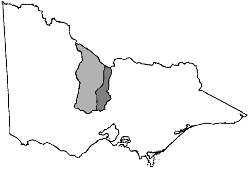
Figure 1 - Loddon River and Campaspe River catchments.
2.4.1 Upper Loddon River Catchment
The Loddon River rises in the Great Dividing Range between Daylesford and Trentham, and extends approximately 300 km north, flowing into the Little Murray River 20 km north of Kerang. At its widest point along the Great Dividing Range, the catchment is 100 km across. The basin covers 15 320 km2, which is 6.8% of the total area of Victoria, with an average annual discharge for the basin of 250 000 ML, representing 1.1% of the total State discharge (DWR, 1989b).
The upper Loddon River catchment includes the Loddon River and all inflowing tributaries, upstream of Fernihurst Weir. The area relevant to the BRFMP also includes a number of impoundments such as Laanecoorie Reservoir, Cairn Curran Reservoir, Tullaroop Reservoir and several smaller storages.
Rainfall is generally low and variable in the Loddon River catchment, increasing with elevation. Daylesford, located in the upper reaches of the catchment, receives an average annual rainfall of 750 mm, whereas Kerang and Boort in the more arid regions of the north have average annual rainfalls of 370 mm and 400 mm respectively (DWR, 1989b).
Major population centres in this catchment include Bendigo, Maryborough, Creswick, Daylesford and Clunes. These centres, together with agricultural activities throughout the catchment, rely on the upper Loddon River and its storages and tributaries as providers of quality water.
McGuckin and Bennett (1999) identified 282 known instream barriers to fish migration and movement throughout the Loddon River catchment comprising:
- 66 stream gauging stations
- 171 farm dams and weirs
- 39 fords
- 1 culvert
- 5 natural barriers
The construction of such structures has resulted in the regulation of streamflow. The large water storage reservoirs (Laanecoorie, Cairn Curran and Tullaroop), along with smaller storages like the Loddon and Kerang Weirs, were designed specifically for the regulation of water for irrigation.
2.4.2 Campaspe River Catchment
The Campaspe Basin occupies 4180 km2 of north central Victoria, and represents 1.8% of the State's area with an average annual discharge for the basin of 280 000 ML, representing 1.3% of the total State discharge (DWR, 1989b).
The Basin is bounded in the south by the northern slopes of the Great Dividing Range and in the east by Cobaw Ridge, McIvor Range and Mt. Camel Range. The western boundary extends from the Murray River and south past the townships of Lockington and Elmore to Bendigo, Kyneton and Trentham.
The Campaspe River is the predominant watercourse in the catchment, with its major tributary being the Coliban River. Both rivers rise separately but nearby on the northern side of the Great Dividing Range in the Woodend/ Kyneton area, before converging within Lake Eppalock and flowing 150 km northwards through the Murray Valley to enter the Murray River at Echuca.
Other major streams in the catchment include the Axe, McIvor, Mt Pleasant and Sheepwash creeks. Major impoundments relevant to the BRFMP are the Upper Coliban, Lauriston and Malmsbury Reservoirs on the Coliban River and Lake Eppalock on the Campaspe River. There are also numerous other smaller storages throughout the catchment.
The Campaspe River has one of the most naturally variable streamflows of all major watercourses in Victoria (OCE, 1988), with periods of very low flow broken by sudden periods of high flows. Rainfall averages 1080 mm at Trentham and 400 - 500 mm in the Northern Plains of the catchment (DWR, 1989b).
The Campaspe River Basin's water is limited and close to being fully committed. Woodend, Kyneton, Tylden, Malmsbury, Heathcote, Tooborac, Axedale and Goornong are supplied from the Campaspe River and its tributaries. In addition to stock and domestic supplies, water is used for the irrigation of areas alongside the Coliban channel system, lower Campaspe River and within the Campaspe Irrigation District.
Agriculture is the dominant land use, with dairying under irrigation the most prominent. In an average year 258,230 ML of water are consumed in the Basin, of which 92% supplies irrigation, 6% supplies rural use and 2% supplies urban and industrial consumption (Bennett, 1991).
McGuckin and Bennett (1999) identified 114 known instream barriers throughout the Campaspe River catchment comprising:
- 79 instream structures, including large storages, stream gauging stations (including fixed crest dam/weirs, gated dam/weirs and other stream gauging weirs);
- 23 minor obstructions (fords/culverts); and
- 12 natural barriers (waterfalls and lakes).
The major population centres in the Campaspe catchment include Kyneton, Trentham, Heathcote, Elmore, Rochester and Echuca.
2.5 Fishes of the Region
A total of 16 native freshwater fish have been recorded from the Campaspe River and Loddon River catchments (NRE, 2000a). Of these species listed, three are migratory species, and eight are listed as threatened fish in Victoria under the FFG. Eight introduced species have also been recorded from these catchments (Table 1).
2.5.1 Key Angling Fish Species in the Bendigo Region
Introduced Species:
- Brown trout,Salmo trutta
This species is native to the cool and cold waters of Europe, and was introduced to Australia in the 1860s as a recreational sport fish (McDowall, 1996). Its distribution has increased through a combination of stocking and migration.
The ideal habitat for this species are cool, well oxygenated waters, such as rivers and streams with moderate to fast flow, and cool clear lakes.
Spawning season extends from autumn into winter. Fish migrate upstream into smaller tributaries and feeder streams, or spawn locally in resident rivers or lakes. Trout require a gravel substrate for the deposition of eggs to ensure sufficient oxygen supply.
Wager and Jackson (1993) reported that this species has had a major impact on indigenous fish species - it is implicated in the decline in numbers of several species such as native galaxiid and pygmy perch, as well as in predation on juveniles of Australian grayling and Macquarie perch.
- Rainbow trout, Oncorhynchus mykiss
This species is native to the pacific coast of North America. It was introduced to Australia in the 1890s from New Zealand where it had been previously introduced from California. As was the case with brown trout it was introduced to satisfy a sport fishing market (McDowall, 1996).
Table 1: Fish species recorded from the Campaspe River and Loddon River catchments, with information on conservation status and migratory habits.
| Native Fish Species | Introduced Fish Species |
| Silver perch 1 2 3 | Brown trout |
| Non-speckled hardyhead 3 | Rainbow trout |
| River blackfish(Loddon Basin only) | Redfin |
| Mountain galaxias | Common carp |
| Flat - headed galaxias 2 3 | Goldfish |
| Western carp gudgeon | Tench |
| Murray cod 1 2 3 | Roach (Campaspe Basin only) |
| Trout cod 2 3 (Campaspe Basin only) | Mosquito fish |
| Golden perch 1 2 | |
| Macquarie perch 2 3 | |
| Crimson-spotted rainbowfish 2 3 |
|
| Southern pygmy perch (unconfirmed) |
|
| Bony bream | |
| Flat-headed gudgeon | |
| Australian smelt | |
| Freshwater catfish 2 3 | |
| Spotted galaxias * |
Rainbow trout are able to tolerate slightly higher water temperatures than brown trout. This species tends to be more successful in lakes than in rivers and streams. However it has been noted that when brown trout and rainbow trout are present together, brown trout tend to dominate.
Spawning requirements for this species are similar to those of brown trout, although they spawn later in the year, during winter and early spring.
Wager and Jackson (1993) suggest that this species has had adverse impacts on native fishes through predation and competitive exclusion.
- Redfin, Perca fluviatilis
Other names: European or English perch
This species was introduced from Europe during the 1860s (McDowall, 1996) and prefers still and slow flowing rivers with abundant aquatic vegetation. Vegetation plays an important part in the life cycle of redfin. During spawning the female disperses eggs amongst aquatic plants, submerged logs and debris.
Redfin feed on a variety of aquatic animals, including molluscs, crustaceans and small fish. This species is thought to have had a negative effect on native fish species including galaxiids and some pygmy perch species, as well as juvenile Macquarie perch and trout cod (Wager & Jackson, 1993).
- Tench, Tinca tinca
Originating from Europe, this species was introduced to Australia in 1876 by acclimatisation societies as a coarse angling species (McDowall, 1996). It generally inhabits slow moving or still waters and tends to favour waters with abundant weed beds and deep sheltered holes.
- Common carp, Cyprinus carpio
Other names: European carp, koi
This species is native to Asia, was introduced to Europe, and from there has become established on every continent except Antarctica. Several strains were introduced into Australia from as far back as 1850 - 60 and as recently as 1961 (McDowall, 1996).
Carp are a very hardy species, and can tolerate very low dissolved oxygen concentrations and extremes of temperature. They prefer still or slow flowing waters with abundant aquatic vegetation, an important substrate for spawning. Spawning generally occurs during spring but can extend into summer if conditions favour.
Young carp hatch quickly and mature rapidly. If environmental conditions favour, carp may reach 500 - 700 mm in just two years (McDowall, 1996). A highly productive species, egg count numbers range from 113 000 to 146 000 per kg of whole fish, with an average of 129 000 (MAFRI, 2000).
Koi carp are an ornamental form of the common carp and have been selectively bred over a number of years.
Carp are declared noxious in Victoria. Under Section 76 of the Fisheries Act 1995, it is an offence for a person to bring into Victoria or take, hatch, keep, possess, sell, transport, put into any container or release into protected waters, a prohibited noxious aquatic species. The illegal introduction of carp into a protected waterway carries a penalty of up to $10 000 for the first offence.
- Goldfish, Carrassius auratus
Other names: Prussian carp, crucian carp
Native to eastern Asia, this species is now distributed almost globally due to its popularity as an ornamental and aquarium fish. Goldfish were first imported into Australia in the 1860s (McDowall, 1996) and are now common in natural waterways.
Their ideal habitat includes still and sluggish waters. Goldfish are common in backwaters of rivers and in billabongs and lakes, and can survive in isolated shallow waterholes in summer. Like common carp the species can tolerate low dissolved oxygen levels and withstand temperatures as low as 0°C and as high as 42°C.
Spawning occurs during spring-summer with females laying eggs among aquatic plants and other submerged objects. Goldfish also breed with common carp to produce hybrids with characteristics representative of both species. Goldfish serve as forage fish for Murray cod, golden perch and other large native predatory fish.
- Roach, Rutilus rutilus
Roach were introduced to Australia from Europe in the 1860 - 70s. They are common in slow flowing rivers, particularly where aquatic plants provide abundant spawning substrate. This species survives well in moderately fast flowing streams and can tolerate brackish water. It can also tolerate temperature changes between 0°C to 38°C.
Adult roach are omnivorous, feeding predominantly on aquatic invertebrates but also consuming aquatic plants. This is a popular angling species in Europe but is of little recreational importance in Australia.
Carp, tench, goldfish and roach are all members of the family Cyprinidae.
Native Species:
- River blackfish, Gadopsis marmoratusOther names: freshwater blackfish, slippery, slimy, greasy, tailor, marbled river cod
The preferred habitat of the river blackfish includes cool, clear streams with a gravel, cobble or boulder substrate and abundant cover. Koehn (1987) showed that the introduction of artificial habitats in the form of boulders and woody debris to otherwise sparse waterways has drastically increased the abundance of this species - confirming its preference for instream habitat and providing shelter from high water velocities.
Spawning occurs in spring and early summer. Eggs are laid in areas of low water velocity such as hollow logs and between boulders; artificial structures such as P.V.C. pipes also provide successful spawning habitat (Koehn & O'Connor, 1990).
It is a carnivorous species, feeding mainly on benthic aquatic insect larvae such as mayflies, stoneflies, dipterans and caddis, as well as other fish, fish eggs, terrestrial insects, crustaceans and earthworms.
This species coexists relatively well with introduced trout species, although feeding requirements overlap and some level of predation occurs.
- Golden perch, Macquaria ambigua
Other names: Yellowbelly, callop, perch, Murray perch, white perch Golden perch prefer warm, turbid and slow flowing inland rivers and their floodplains, lakes and anabranches.
Spawning occurs at night in spring and summer during the flood period when water temperature exceeds 23°C. Females of this species can withhold eggs until favourable environmental conditions occur, otherwise ovaries are resorbed until the next spawning season.
A predator fish, golden perch are opportunistic feeders, feeding on crustaceans, small fish, molluscs and insect larvae.
- Macquarie perch, Macquaria australasica
Other names: Silvereye, white-eye, mountain perch, bream, black bream
Macquarie perch are listed under the FFG (Threatened Species), because of limited distribution and ongoing decline in abundance. Reduction in numbers has been attributed to a combination of factors including overfishing; degradation of habitat through siltation and river regulation, and possible competition with introduced species. Epizootic haematopoietic necrosis (EHN) is a disease carried by redfin, which is fatal to Macquarie perch and may also have contributed to its decline.
Spawning occurs in October and November when water temperature reaches at least 16°C in shallow upland streams. Impoundment fish migrate upstream for spawning, however it is not certain that riverine fish do the same. Eggs are laid in riffles with a water depth of 50 - 75 cm and flow of about 1 metre per second (McDowall, 1996).
Mature fish feed on a diet of stream invertebrates, particularly aquatic insects. The decline in numbers of this species has led to a restocking program.
Recreational angling for this species is prohibited throughout Victoria with the exception of Lake Dartmouth, the Upper Coliban Reservoir, the Yarra River, and their tributaries. A closed season currently exists between 1 October and 31 December.
- Freshwater catfish, Tandanus tandanus
Other names: tandan, eel-tail catfish, freshwater jewfish, kenaru
This species is a non-migratory benthic dweller of lakes and slow flowing rivers, and spawning occurs during spring and summer. Adults build a nest of pebbles and gravel for fertilised eggs to settle into. One parent remains with the eggs until hatching.
Catfish consume a varied diet but are predominantly carnivorous bottom – feeders. Juveniles feed on zooplankton and small insects, adults on shrimps and crayfish in summer and midge larvae in winter. Diet also includes dragonfly, caddis and mayfly larvae and molluscs. During flood periods catfish also feed on terrestrial invertebrates such as earthworms, termites and beetles.
Freshwater catfish are listed under the FFG, (Threatened Species). Recreational fishing for freshwater catfish in all Victorian waters outside the Wimmera River Basin is prohibited.
- Murray cod, Maccullochella peelii
Other names: cod, codfish
This is Australia's largest wholly freshwater fish. Its abundance and distribution have declined dramatically through a combination of environmental degradation; competition with introduced species such as carp, and overfishing. Stocking programs are now in place to attempt to build up the numbers and range of this species throughout Victoria.
The natural habitat of Murray cod ranges from small clear rocky streams to turbid slow flowing rivers and creeks, with fish usually residing in or near deep holes. Rocks, fallen trees, overhanging vegetation, root systems, stumps and other forms of cover provide essential habitat.
Spawning occurs when water temperature reaches about 20oC usually from September to November however in colder areas spawning may occur later. Eggs are laid onto submerged structures and males guard eggs until hatching.
Murray cod are voracious feeders, and are the top predator in inland waters. Their diet consists of fish, crustaceans, molluscs, frogs, turtles and even water birds, terrestrial snakes and mice.
Murray cod are listed under the FFG, (Threatened Species). Angling restrictions apply for this species and are outlined in the Victorian Recreational Fishing Guide.
- Silver perch, Bidyanus bidyanus
Other names: black or silver bream, bidyan
A schooling fish, populations of this species have declined significantly, resulting in silver perch being classified as critically endangered (NRE, 2000d) and listed as threatened under the FFG.
Construction of dams and weirs, and competition for food from introduced species, are suggested as major causes of the decline. Stocking programs are now in place to replenish wild stocks. Preferred habitat is fast flowing waters with rapids or races; open waters rather than heavily snagged areas are preferred.
A wide range of water temperatures can be tolerated, from 2°C to 37°C, with spawning triggered by a rise in water levels coupled with an increase in water temperature during spring and summer. Following an upstream migration, semi-buoyant eggs are released into the water column to drift downstream.
Adult silver perch are omnivorous, feeding on zooplankton, shrimps, yabbies, aquatic insects, molluscs and filamentous algae.
Part 3: Key Management Strategies and Actions
Key management strategies with specific supportive actions are set out in this section.
They seek to balance the protection and improvement of the environment for fishing, as well as to provide a sound basis for the future of fish and recreational fishing.
They also highlight the need for strategic partnerships and commitments across all relevant agencies as well as asserting the role of the fishing community.
This section of the BRFMP breaks the fishery down into key issues. Strategies and actions are developed for each issue based on ecological status and requirements and on the views and wishes of anglers. These strategies and actions also have regard for other natural resources and users of the habitats concerned.
All strategies and actions are designed to be consistent with the overriding mission for management of the Bendigo Region Fishery, and wherever possible are clearly measurable so that anglers and managers can be confident that suitable progress is being made. The Fisheries Act 1995 (VIC) states that all fisheries management plans must specify performance indicators, targets and monitoring methods.
The appropriateness of the BRFMP's provisions and the level of success achieved will be measured by the degree to which overall and specific strategies and actions are met. It is necessary for managers and anglers to monitor this collectively on an ongoing basis.
As more information on the fishery comes to light, management requirements will change and new needs will be identified. Also, the aspirations of anglers and fishing traditions will continue to evolve and subtly change over time. For these reasons it will be necessary to review and update the BRFMP from time to time.
3.1 Introduced Fish Species
The Victorian Fish Database (NRE, 2000a) lists eight introduced fish species as present in the Loddon and Campaspe river basins, these being brown trout, rainbow trout, redfin, common carp, goldfish, tench, roach and mosquito fish. Many of these species have formed self-sustaining populations.
Both common carp and mosquito fish have been declared noxious under the Fisheries Act 1995. These species adversely affect the environment in many ways, including increasing turbidity and nutrient loads, and possible predation on eggs of threatened native or more desirable introduced fish species.
Roach and goldfish are two known carriers of the bacterium that causes the goldfish ulcer disease Aeromonas salmonicida, which can infect and cause mortalities amongst desirable angling species.
The translocation of live baitfish and intentional release of noxious and pest fish species pose a threat to existing native and introduced fish populations through direct competition and the threat of disease.
The introduction of fish outside their natural range is considered a threatening process (under the FFG), having the capacity to adversely impact on native species and biodiversity. In these circumstances these fish could be considered pests. Examples in the Loddon and Campaspe river basins include roach and the spotted galaxias.
Roach are believed to have spread through illegal introductions as an angling species and their use as live bait. Fisheries Victoria has been requested by the Parks, Flora and Fauna Division of NRE to have roach declared a noxious species.
Spotted galaxiids, although native to Victoria, normally occur in the coastal drainages at low altitudes and relatively close to the sea. This species is believed to have spread north of the Divide through its use as live bait.
Carp are a major problem in waters throughout the region, particularly in the lower reaches of the catchments. They are hardy and reproduce very successfully.
Carp are predominantly benthic feeders, sucking up loose sediment while foraging for food, increasing turbidity in the overlying water and contributing to the re-suspension of nutrients.
Feeding at the water's edge is often observed and is widely believed to contribute to undercutting which eventually results in bank collapse (Roberts & McCorkelle, 1995)
It has also been suggested that in high densities, carp may alter habitat through damage of soft leaved plants in shallow wetlands. This has been observed in some New South Wales wetlands.
Experiments by Roberts et al (1995) showed that adding carp to experimental ponds led to an immediate effect on water quality, a rapid effect on physico-chemical properties of the water column, and a persistent loss of specific structural components. Although representative of pond systems, results were suggested to be relevant to river systems as well.
It should be noted that it is an offence under the Fisheries Act 1995 for a person to bring into Victoria, or take, hatch, keep, possess, sell, transport, put into any container or release into protected water, a prohibited noxious aquatic species.
Strategy 1
Determine, monitor and review the status of f ish populations, and develop and update an environmental profile for fish at each principal storage
Goals 1,2,3,4
Action 1.1
Support the development of, and distribute current status assessments of, the principal fisheries in the region for comment, review and ongoing update.
Action 1.2
Revise management arrangements in response to changes in the biomass (population) of fish generally, or of species in particular.
Action 1.3
Determine and prioritise the storages and rivers for the development of an environmental profile of and for fish having regard to available information. Each profile to include the following information:
- fish species and population
- environmental flows
- fish movement/passaged) breeding and stocking
- fish health
- aquatic habitat (including water quality and temperature)
- flood-plain (terrestrial) habitat
- threats and risks including impacts from exploitation
- relevant Flora and Fauna Guarantee Act 1988 considerations
Strategy 2
Minimise detrimental impacts on fisheries from the introduction of potentially harmful fish species
Goal 1
Support the Flora and Fauna Guarantee processes with emphasis on the following:
Action 2.1
Investigate the effects of introduced angling species such as brown trout, rainbow trout and redfin on recent native fish stockings.
Action 2.2
Support and promote legislation that aims to protect the desirable fish species in a particular area from threatening processes.
Action 2.3
Support and assist where possible in carp control methods.
Action 2.4
Identify the impacts of carp and roach, and reduce numbers of carp, roach, goldfish and tench by encouraging increased recreational and commercial exploitation.
Action 2.5
Support the declaration of roach as a noxious species under the Fisheries Act 1995.
Strategy 3
Maintain existing trout and redfin fisheries in the Bendigo region, whilst minimising detrimental effects on native fish populations
Goal 4
Action 3.1
Continue to stock brown trout and rainbow trout in accordance with the current Fisheries Victoria Salmonid Stocking Policy.
3.2 Threatened or Vulnerable Native Fish Species
Sixteen species of native fish have been recorded from the Campaspe and Loddon river basins. Of these, approximately half have been listed as threatened species under the FFG, those being silver perch, non-speckled hardyhead, flat-headed galaxias, Murray cod, trout cod, Macquarie perch, crimson-spotted rainbowfish and freshwater catfish.
Trout cod are currently totally protected in all Victorian waters. As part of the Flora and Fauna Guarantee program an action statement has been formulated for this species which outlines actions to ensure the long-term survival of the species (FFG Action Statement No. 38).
The threatened status of several other popular angling species has necessitated angling restrictions:
- Macquarie perch may only be taken from Lake Dartmouth, the Yarra River, the Upper Coliban Reservoir and their tributaries.
- Silver perch may only be taken from lakes and impoundments north of the Great Dividing Range excluding the Wimmera Basin, however this species may be taken from all other waters south of the Great Dividing Range, including the Wimmera Basin.
- Freshwater catfish may only be taken from waters within the Wimmera basin.
Catch and size limits, and open seasons apply to these and other native fish species. These are outlined in the Victorian Recreational Fishing Guide.
Strategy 4
Protect and enhance natural populations of Flora and Fauna Guarantee 1988 listed fish species
Goals 1,2,3
Action 4.1
Comply with conservation programs developed by Parks Flora and Fauna on behalf of NRE; develop and implement a communications strategy and promote a program to better inform fishers of all issues affecting fish and fishers.
Action 4.2
Support conservation stockings to establish populations of threatened species and to supplement remnant populations in accordance with NRE's current Native Fish Stocking Policy.
Action 4.3
Encourage the timely preparation of Action Statements as described under the FFG for silver perch, Macquarie perch, Murray cod, freshwater catfish, crimson spotted rainbowfish, non-speckled hardyhead, flat headed galaxias and the lowland fish community.
Action 4.4
Advocate the development of a detailed information base of the habitat requirements of threatened fish species.
Action 4.5
Identify, register, publicise and share the knowledge of habitat areas that are significant to threatened fish species.
Action 4.6
Encourage the creation and protection of specific and abundant habitat for threatened and diminishing fish species.
Action 4.7
Encourage anglers to recognise trout cod and other threatened fish species.
3.3 Habitat
3.3.1 Riparian vegetation
Many areas within the Loddon River andCampaspe River catchments exhibit poorriparian cover. In many cases vegetation hasbeen removed or damaged by several processesincluding:
- Deliberate modification of streams (such as creation of channels) which has resulted in the destruction/removal of native trees and shrubs.
- Clearing of land for agriculture.
- Stock access, which has prevented regeneration of native species through trampling and grazing.
- Planting and the consequential spread of exotics (such as willow species) which have overrun native species and prevented their regeneration.
- Recreational activities.
A healthy riparian zone is extremely important for the health of rivers, streams and lakes. The zone serves many environmental purposes, such as:
-
Improving water quality by:
- reducing velocities of runoff water
- trapping nutrients which results in reduced algal growth;
- lowering water tables
- filtering light to control algae and aquatic vegetation growth
-
Stream stabilisation by:
- binding soils to prevent erosion
- providing frictional resistance to overbank flow, reducing erosive potential
-
Providing instream habitat by:
- shading which reduces the likelihood of excessively high water temperatures
- trapping sediments that could otherwise fill pools in the bed
- providing a food source for benthic organisms and providing habitat for insects and the fish that feed on them
-
Nature conservation by:
- providing wildlife corridors
- providing habitat
-
Fire management by:
- retaining moisture during summer months
- acting as a windbreak to summer north winds
Riparian vegetation also serves several nonenvironmentalpurposes such as:
- providing shelter for pastures and crops from debilitating winds
- enhancing appearance of farmland, adding to land and landscape values
Indigenous vegetation is adapted to grow in the local soils and climatic conditions. It provides the habitat requirements for a wide range of fauna species that may not be provided by exotic plant species. Several exotic pest plant species are established along the waterways of the Bendigo region, notably crack and weeping willow, gorse and blackberry.
Although these species offer short-term stabilisation benefits, watercourses dominated by introduced species show marked physical modification and habitat changes. Altered watercourse behaviour and displacement of indigenous plants and animals are often consequences.
Thick streamside growth of gorse and blackberry does offer some protection from stock and can, when overhanging the water, provide refuge for fish. Terrestrial organisms that live in the blackberries in particular also fall into the stream, providing a regular source of food for aquatic organisms along with the berries themselves.
Ideally, all waterways would have healthy riparian strips, comprised of a diversity of native trees, shrubs and grasses. However, it should be noted that any form of streamside vegetation provides some level of benefit to the environment (be it river red gum or crack willow). As such, care should be exercised in the planning and management of riparian lands - a tree is better than no tree, and an indigenous tree is better than an exotic tree.
3.3.2 Fish passage
The unimpeded passage of fish throughout streams is crucial for spawning migration, re-colonisation, general movement and habitat selection. Under section 119 of the Fisheries Act 1995 it is an offence to obstruct the passage of fish.
Barriers restrict movement of native fish that must migrate to complete their lifecycle and can geographically isolate fish populations, reducing genetic variation. Barriers can also alter the quality, quantity and timing of water delivered downstream, potentially affecting the habitat, breeding and feeding grounds of native fish (McGuckin & Doeg, 2000).
Schedule 3 of the FFG lists the prevention of passage of aquatic biota as a result of the presence of in-stream structures as a potentially threatening process. Restoring fish passage, either by removing barriers or by installing fish-ways, is possibly the most immediate, demonstrable improvement that can be made to the conservation of native fish in the catchments.
The State Fishway Program has identified over 100 high priority sites across Victoria and is currently undertaking a program to provide fish passage at these sites. Two sites on the Loddon River and one site on the Campaspe River have been identified as requiring urgent attention.
3.3.3 Uncontrolled stock access
Uncontrolled stock access to waterways results in bank instability and destruction of soil structure. Destruction of undercut banks and streamside vegetation by trampling may result in loss of habitat for fish and other aquatic biota.
Riparian vegetation is damaged through grazing and trampling, and weed invasion is facilitated through seed spreading from faeces and destruction of native plants.
Stock access also creates water quality problems associated with nutrient influx from faeces and urine, such as blue-green algal blooms, decreased dissolved oxygen, increased faecal coliforms and increased turbidity.
The proper management of stock is most important in the protection of stream frontages. In most cases, fencing of the stream combined with well placed watering points (off-stream or on-stream) may represent the best solution (NRE, 2000c).
In areas where stock need to be excluded from damaged banks, concrete or gravelled walkways can allow stock access to water. Alternatively, off-stream water storage could be provided. Funding and subsidies are available for fencing and revegetating riparian lands through NRE and the North Central Catchment Management Authority (NCCMA).
3.3.4 Siltation
Siltation is considered a major factor destroying available habitat for fish and other aquatic animals. The resulting layer of mud provides little or no shelter for aquatic animals, as it covers rocks, crevices, woody debris and other instream habitat.
Silt may bury the benthic eggs of some fish species such as river blackfish. Silt can also inhibit the ability of many plants to photosynthesize, resulting in loss of productivity.
Eventually siltation reduces depth and may alter stream hydrology through the formation of silt banks. The decrease in capacity of reservoirs resulting from long-term silt deposition is also of concern.
3.3.5 Environmental flows
In the past, environmental values of rivers have been largely overlooked due to high demand for limited water resources for domestic, industrial and agricultural purposes. Today, government agencies are aware of the importance of maintaining adequate flows to preserve natural flora and fauna and to provide an important stimulus for spawning in many native species.
Environmental flows are volumes of water set aside for the environment, that cannot be bought or sold. These flows provide a way of reducing the impact of regulation on river and stream plants and animals.
Flows are selected during the design construction stage of a storage to best meet the downstream requirements, whilst maintaining the principle that a storage is designed for conservation of water. However, in many instances experience has shown that these flows are inadequate and are thus altered.
The Loddon-Campaspe irrigation season extends from October through to May. Water is released from lower down in the storages, and as such is often very cold. This conflicts with the breeding requirements of many species of native fish - golden perch, for example, spawn in spring-summer when water temperature reaches approximately 23oC.
One of the major problems encountered with environmental flows is a lack of knowledge about individual systems and about the biological requirements of instream plants and animals.
It should also be noted that central Victoria is regularly subject to periodic drought, and as such it has not been possible to maintain environmental flows down the Campaspe River.
3.3.6 Erosion
Stream bank erosion occurs under natural conditions, particularly during peak storm flows, and is part of an on-going cycle of sediment erosion and deposition within the stream system. However, large-scale changes to streams and their catchments since European settlement have greatly accelerated this process and many streams have become potentially unstable as a new balance is sought.
Stream bank erosion may be caused by increased run-off from cleared catchments, clearing of riparian vegetation, unrestricted stock access to streams, stream modification (such as creation of channels or de-snagging) resulting in increased water velocity along the length of the stream, and decreased structural stability.
Other factors contributing to stream bank erosion include vehicle access, rabbits (reduced plant cover and burrowing weakening banks), fallen logs or willows creating instream islands and forcing water into stream banks, and deepening of the stream bed either through dredging or through increased water velocity.
Stream bank erosion may result in water quality problems, invasion by noxious weeds once native vegetation is depleted and soil is exposed, reduction in vegetated streamside margins and the subsequent loss of habitat for fish and other animals, as well as damage to roads, bridges and levee banks.
Of high priority in managing stream bank erosion is the protection and maintenance of existing riparian vegetation. Revegetation works are complex and potentially costly, as erosion control structures may need to be built prior to commencing revegetation works. If revegetation work is necessary, diversity of native vegetation type and species should be sought by planting grasses, sedges, shrubs and trees so that maximum ground cover and protection is achieved.
Steep banked areas of reservoirs may also be subject to severe wind-generated wave erosion. This slope may impact on erosion in three ways:
- immediately adjacent to the shore the lake will be relatively deeper, and hence wind generated waves will have higher energy;
- in the event that the slope is undercut by erosion it will be less stable and more likely to collapse, evacuating a large amount of material; and
- evacuated material is more likely to be transported down into the lake than to sit at the shoreline and protect the bank by dissipating wave energy (Davis, 1998).
Riparian vegetation plays an important role in stabilising shorelines of impoundments by binding together soil and absorbing some of the wave energy. Loose rock on banks around impoundments may also protect soil from wave action by providing a solid barrier.
Strategy 5
Provide environmental flows that as far as possible mimic the natural flow regime of rivers and streams in the Bendigo Region
Goals 1,2,3,4
Action 5.1
Support the development of operational changes to regulated releases from all major water storages as described in the NCCMA's Investigation of Aquatic Ecosystems of the Campaspe Catchment (McGuckin and Doeg, 2001).
Action 5.2
Support potential water savings within the irrigation and domestic distribution systems as described in the NCCMA's Investigation of Aquatic Ecosystems of the Campaspe Catchment (McGuckin and Doeg, 2001).
Action 5.3
Identify environmental flow regimes required to improve existing aquatic habitat.
Action 5.4
Support water management strategies that maximise survival and growth of recently recruited or released trout or native fish.
Strategy 6
Promote recognition of the importance of environmental flows, particularly in times of drought
Goals 1,2,3
Action 6.1
Encourage the enhancement of environmental flows through review of the triggers and environmental aspects of the bulk entitlement process; support other agencies to develop long-term targets in environmental flows at agreed times and volumes.
Strategy 7
Maintain and enhance riparian vegetation and minimise the effects of threatening processes on riparian health
Goals 1,2,3
Action 7.1
Protect and restore native riparian vegetation and restrict stock access as outlined in the NC CMA's Investigations of the aquatic ecosystems of the Loddon and Campaspe Catchments (McGuckin & Doeg, 2000and McGuckin & Doeg, 2001).
Action 7.2
Promote habitat restoration/rehabilitation through support and encouragement of habitat restoration projects.
Action 7.3
Develop low cost options for habitat replacement.
Action 7.4
Support and encourage the removal of exotic vegetation, primarily willows, in areas where removal will not exacerbate environmental problems.
Action 7.5
Support the policies and programs under the Catchment and Land Protection Act 1994 (Vic) towards the control and removal of pest plants and animals deleterious to aquatic and terrestrial life and biodiversity.
Strategy 8
Advocate fish movement throughout rivers and storages
Goals 2,3,4
Action 8.1
Support the development and management of the Victorian State Fishway Program Weir Review.
Action 8.2
Encourage reduction of the number of existing barriers to fish movements.
Action 8.3
Assess all instream structures with a view to the potential for eventual removal, modification or altered operation.
Action 8.4
Encourage any future storages or structures to incorporate a fishway into initial construction plans as a priority action.
Strategy 10
Support environmental protection and improvement policies and programs of water storage managers
Goals 1,3
Action 10.1
Promote understanding and acceptance of the key roles and obligations of water storage managers.
Action 10.2
Seek the integration of relevant sections of the BRFMP with the storage management plans of water storage managers.
Action 10.3
Promote the principle of mutual obligation and active commitment between all the relevant agencies and groups in the implementation of the BRFMP.
Action 10.4
Maintain frequent dialogue between NRE, water storage managers and fisher representatives.
Action 10.5
Support water storage managers or catchment authorities in their investigation and implementation of fish zones or reserves having regard to water quality, fish refuge, boating and angler access.
3.4 Water Quality
Water quality is emerging as arguably the most important issue in environmental management. Appropriate catchment management is critical to the long-term wellbeing of the streams, rivers and lakes of the Bendigo region.
A range of catchment and water-based activities influence water quality, and poor management manifests itself in many forms,some more visibly than others.
3.4.1 Algal blooms
The frequency and intensity of toxic blue-green algal blooms in particular has become an ever increasing problem over recent years, for both the environment and for domestic, agricultural, industrial and recreational users of water.
Whilst tastes and odours can make water objectionable for drinking and recreation, toxic blooms can have serious health implications for humans, fish, birds and other animals when contaminated water is contacted or consumed. Effects of toxins are an issue not only at the bloom site, but downstream as well.
Algal blooms occur when environmental conditions are extremely favourable to their growth. A bloom is the result of a complex interaction of a number of environmental factors including nutrient availability, sunlight, turbidity, pH, temperature, salinity, conductivity, carbon availability, calm weather conditions, river flow and water storage levels.
Blooms tend to occur in shallow, stagnant or low-flow water bodies with high nutrient loading, and are more common in the summer months when water temperatures and photoperiod increase. However, at present it is not possible to attribute algal blooms to any one specific factor, and the exact combination of factors that triggers and sustains an algal bloom is undetermined.
The Nutrient Management Strategy for Victorian Inland Waters (Government of Victoria, 1995) was launched in response to the increased number of reports of potentially toxic bluegreen algal blooms and to prevent further deterioration of water quality in Victorian waterways.
The Nutrient Management Strategy for Victorian Inland Waters provides a policy and planning framework to assist in identifying and managing particular nutrient problems, and to minimise the potential for the development of algal blooms. Research to date suggests that the best way to reduce the frequency and severity of algal blooms is to maintain adequate flow to flush waterways.
3.4.2 Salinity
Salinity is identified as the greatest single threat facing Victoria's environment and refers to the movement and concentration of salt in landscapes.
Fish and other wholly aquatic organisms within the Loddon River and Campaspe River catchments may die once salinity levels exceed their tolerance levels. Fish are often particularly vulnerable to the effects of salinity in the early life stages and its toxicity may also depend on the length of exposure and the acclimatisation rate.
Effective salinity management requires a total catchment management approach. The longterm solution to salinity is to restore the balance of inputs and outputs of the soil-water system by controlling the process of groundwater recharge. Treatment of salt affected land is an important component of salinity management.
Salinity Management Plans are currently in existence for both the Loddon River and Campaspe River catchments (LCWG, 1992 and CCWG, 1992).
3.4.3 Turbidity
Turbidity is caused by the suspension of particles in the water. These are most commonly soil particles, although other particles may include detritus or algae. Turbidity causes a reduction in the transmission of light. High turbidity lowers the acceptability of water for drinking purposes, and by absorbing light may restrict plant photosynthesis and oxygen production in the water. Turbidity also increases the costs of potable water, as it has to be filtered.
Soil loosened by erosion and stock access washes into the river, resulting in increased turbidity.
Turbidity affects fish both directly and indirectly. Particulate matter in the water eventually causes gill damage, and decreased light penetration results in reduced productivity and hence a lack of food.
The headwaters of rivers and streams in mountain regions tend to have low turbidity, whereas high turbidities usually occur in the lowland river reaches. Turbidity within lakes and impoundments is affected by the nature of feeder streams. surrounding land use, and soil types.
Increased turbidity can result from a range of land management practices which increase sediment loads in the water, including catchment and riparian land clearing, over irrigation, unrestricted access of stock to waterways, removal of aquatic vegetation, and bank destabilisation. Unsealed roads, road crossings and inappropriate drainage can also contribute large amounts of sediment to streams. Soils can also be exposed by wildfire. If heavy rains follow the wildfire, turbidity levels can be increased markedly, particularly on a local scale. High numbers of carp may also be a major contributing factor to turbidity in many water bodies.
3.4.4 Chemical pollution
Potential sources of chemical contamination in the Loddon River and Campaspe River catchments include:
- runoff from agricultural catchments following rainfall;
- drainage discharge points from irrigation developments;
- forestry operations;
- intensive rural industries, particularly livestock production;
- discharges from both domestic and industrial sewage systems;
- stormwater and drainage from sealed road surfaces; and
- heavy metal contamination from mine tailings.
Poorly managed agricultural systems can contribute significant quantities of agricultural chemicals to waterways through runoff, airborne drift from spraying, infiltration of chemicals to the soil profile and subsequent contamination of ground water resources.
Common agricultural pollutants are fertilisers and pesticides. In sufficient concentrations, these chemicals are toxic to fish and other aquatic life. Fertilisers and animal waste from agricultural land also facilitate nutrient loading.
Seepage from septic tanks adjacent to waterways can result in increased faecal coliform bacteria, posing health risks both for humans and stock. Recreational uses such as swimming are also potentially affected. Increases in phosphorous and nitrogen levels associated with sewage pollution may also stimulate algal blooms.
Motor boating in rivers and on lakes and impoundments may result in the introduction of heavy metals such as lead, carbon monoxide from fumes, and petroleum products from unburnt fuel and oils. These products may have drastic effects on resident biota.
A long history of mining in the catchments has resulted in the introduction of heavy metals such as mercury. Mercury was used in goldmining and processing operations to remove free gold from concentrates, and as such found its way into waterways from tailing dams. The health implications of excessive mercury concentrations are enormous.
EPA studies show high mercury levels in Victorian tailings dams that serviced batteries; many of these tailings dams would be regarded as contaminated sites.
Mercury is considered the most toxic metal found in the freshwater environment. Mercury tends to bind with organic particles, settle out of the water column and accumulate in the sediments. Some research suggests that microbiological processes in the sediments can transform the mercury into the more toxic methyl mercury form.
Many aquatic organisms can accumulate mercury either from the water or through their food chain. Research indicates that mercury and inorganic mercury can be eliminated from the organism while methyl mercury is retained and accumulates.
Fish have very primitive kidneys and are unable to excrete large quantities of mercury, and therefore mercury accumulates in the flesh. Mercury poisoning in humans is usually the result of eating contaminated fish and molluscs.
In Victoria, research by the EPA has shown that many streams flowing through old goldmining areas have elevated mercury levels in their sediments. The data indicates that old tailings deposits with elevated mercury levels are the source of contamination.
Strategy 11
Support the development of responses to indentifiable threats to fish generally or to specific species
Goals 1,2,3,4
Suggested "areas" where relevant agencies may be supported in this strategy include:
Area 11.1
Encourage the relevant agencies to identify all forms of potential contamination of water with an adverse impact on aquatic life.
Area 11.2
Make representations to all relevant agencies to have appropriate responses, including emergency plans, for spills and other contamination.
Area 11.3
Encourage the assessment and remediation of the impact on fish of thermal pollution (if present) and stratification.
Area 11.4
Educate fishers and the community as to the impact on fish of water contamination and pollution of the water (however slight).
Strategy 12
Minimise the effects of catchment practices on waterways and aquatic ecosystems
Goals 1,2,3,4
Action 12.1
Encourage the maintenance and provision of adequate buffer zones around rivers, streams and lakes, comprising a range of native trees, shrubs and grasses.
Action 12.2
Support the responsible use of farm chemicals such as pesticides and fertilisers, and the reduction of the use of substances with residual consequences harmful to aquatic life.
Action 12.3
Advocate the creation of a buffer zone around water storages and rivers for no spraying of substances that are known to adversely affect the riparian and aquatic fauna.
Action 12.4
Monitor heavy metal and pesticide/herbicide residues in the long-lived species of fish targeted by anglers.
Action 12.5
Promote the control of stock access to waterways by fencing.
Strategy 13
Reduce the detrimental effects of erosion on waterways in the Bendigo Region
Goals 1,2,3
Action 13.1
Support and assist in erosion control measures in areas of severe erosion.
Action 13.2
Support and encourage revegetation programs in areas susceptible to, or affected by, significant erosion events.
Action 13.3
Encourage the installation of instream sediment traps whilst ensuring fish passage if appropriate.
3.5 Access and Facilities
There appears to be some confusion amongst anglers over what rights of access anglers have to waterways in the Bendigo region.
The only land to which anglers have legal access are unused and used government roads and other designated rights of way. Anglers' access rights have never, in any part of the region, included the provision to cross private land, particularly with vehicles, to gain access to the designated rights of way and fishing locations.
However, the use of farm tracks and formed roads over private land to get to popular fishing sites is a widespread and common practice throughout the Bendigo region, at the goodwill of landowners. Anglers need to appreciate that they enjoy access additional to that afforded by public roads and the designated rights of way, courtesy of landowners. However landowners have the right to exclude the public if they choose, and anglers must respect this right.
Water authorities own and manage man-made storages throughout the Bendigo region. Many of these storages are also popular recreational destinations. It should be noted that authorities supply facilities for boating/fishing at the expense of the authority, and have no legal requirement to do so or to allow access to the storages.
Water authorities would like it recognised that water levels will fluctuate as required for the management of the water supply systems, and that from time to time reservoirs will be closed for management reasons, or may be drained completely for maintenance purposes or due to drought. Authorities may also restrict access or close storages for public safety reasons.
There are particular rules governing use of potable water storages for recreation. These include that no one may enter the water body for fishing (for example, wading, including use of float tubes, and boating are not permitted).
Consultation with anglers has suggested that anglers do not necessarily want more access, but better access. By providing adequate facilities, a greater proportion of the community will be able to benefit from the region's fisheries resources.
There is an increasing awareness of the need to provide angler access for junior, disabled and elderly members of the community. Managing authorities support such ventures, however safety considerations govern the suitability and location of the relevant structures.
An important step in improving the recreational fishery is creating signage for existing public access points. Improved signage has many benefits, such as allowing visiting anglers to find a place to fish, informing anglers of where facilities are located and of any zoning or regulations, and encouraging participation.
Some waterways in the Bendigo region attract very high visitation with angler activity concentrated around existing access points. This exerts enormous pressure over a relatively small area of the fishery. In cases such as this, additional access points may be of benefit, as they will spread fishing pressure over a larger area.
Strategy 14
Provide access and facilities which enable anglers to participate across the full range of fishing opportunities within the fishing district
Goals 3,4
Action 14.1
Support the maintenance of existing access points and facilities to an acceptable standard, and investigate ways to achieve improved facilities.
Action 14.2
Support and assist where possible in developing access points for disabled/junior/elderly anglers.
Action 14.3
Investigate options for increasing access points through used government roads, non-renewed leases and public reserves.
Action 14.4
Identify funding options for improving access and facilities at locations throughout the Bendigo region.
Action 14.5
Promote, where appropriate, development of multi-use facilities, including fishing in decommissioned water storages.
Strategy 15
Minimise conflicts between resource users and the detrimental effects of angler access
Goals 3,4
Action 15.1
Encourage anglers to acknowledge and respect the rights of landowners and the obligations of water storage managers.
Action 15.2
Support and encourage public access agreements between landowners, anglers and other water users.
Action 15.3
Endorse the development of an angler code of conduct that encourages anglers to take a responsible approach to minimising the impacts of their activities on the environment, facilities, private property and other people's enjoyment, with emphasis on litter, fires and camping refuse.
Action 15.4
Identify and define public access points and improve angler access opportunities through signage and development of landholder relations.
Action 15.5
Investigate the potential for opening up additional access points in some areas to reduce fishing pressure on popular access points.
Action 15.6
Support and assist in mechanisms for notifying the public of the location of angler access points to popular waterways.
3.6 Fisheries Compliance
A recreational fishing licence is required for all forms of recreational fishing in all of Victoria's marine, estuarine and fresh waters.
The Recreational Fishing Licence (RFL) applies to the taking, or attempting to take, of any species of fish by any method, which means it covers more than just line fishing. The licence also covers other activities such as bait collection, gathering shellfish, yabby fishing, prawning and spear fishing.
The current regulations for recreational fishing in Victorian waters are summarised for recreational anglers in the Victorian Recreational Fishing Guide, which is updated annually.
Angler education is an important tool in the management of the Bendigo region's fisheries.
Programs such as 'fishcare' or other volunteer programs may be of benefit to the Bendigo region by promoting angler awareness and appropriate conduct.
There is also a need to ensure effective deterrents to potential offenders, such as fines and other penalties.
The community has demonstrated a level of interest and involvement in fisheries management. Education programs should strategically channel some of this demand and ensure that participation is in effective programs.
Strategy 16
Protect fish populations and angling values through compiance with the fishing regulations
Goals 1,3,4
Action 16.1
Promote the principle of community ownership of the fisheries resources in the region, and thus encourage an element of selfpolicing within the angling community.
Action 16.2
Promote compliance with fisheries regulations through a combination of public education, information and enforcement strategies.
Action 16.3
Encourage anglers to report incidents to NRE as and when they occur and to work with NRE in combating illegal activity.
Action 16.4
Maintain and enhance the NRE's enforcement capabilities through the provision of appropriate staffing, training and resources.
Action 16.5
Enhance community education.
Action 16.6
Develop community education programs in the following areas:
- junior angler education
- responsible angler conduct
- land management practices
Action 16.7
Maintain and update the website www.fishingbendigo.com as a means of communication between anglers, Fisheries Victoria and other managing authorities.
Action 16.8
Support and assist in the implementation of volunteer programs such as 'fishcare'.
Action 16.9
Identify strategic enforcement priorities based on knowledge of where non-compliance poses the greatest threats to fish resources.
Strategy 17
Support VRFish and recreational anglers in monitoring the effectiveness of State regulations
Goals 1,3,4
Action 17.1
Promote the need and benefits for all fishers to be licensed (unless exempted under the Fisheries Act 1995 from that requirement) and to be better informed of State laws and regulations.
3.7 Angler Education
The conduct of anglers themselves can have a significant effect on the environmental health of fisheries in the Bendigo region. It is important for anglers to recognise the effects of their actions on the environment and behave responsibly.
Rubbish in and around waterways (including discarded fishing line) may pose a threat to animals and is aesthetically unappealing. Proper handling of fuels used for boating is also important, as spills are toxic to biota.
Anglers enjoy vehicle access to many waterways throughout the region, however irresponsible driving may result in the destruction of vegetation and valuable habitat, increased turbidity and sediments, and bank degradation.
Camping around waterways is common in the Bendigo region. It is important, however, for campers to behave in a manner that minimises their impact. This includes appropriate sanitation measures (for example, toilet facilities should be located well away from waterways).
The removal of woody debris around waterways is a major problem in the Bendigo region. Low water levels have left stumps, trees and branches exposed. These are often removed or burnt as firewood, depriving the fishery of vital habitat when water levels resume.
Strategy 18
To increase angler awareness of the environmental effects of their conduct and to minimise impacts
Goals 1,4
Action 18.1
Support the identification of appropriate vehicle access around waterways.
Action 18.2
Support the provision of sanitary facilities at locations where appropriate.
Action 18.3
Promote the development of an angling 'Charter of Care'.
3.8 Implementation
Perhaps the key factor that will determine the level of success of the BRFMP and its credibility among stakeholders will be the commitment of funding to implement the actions and strategies outlined above. The final BRFMP will require an implementation strategy setting out the commitment of all key participating agencies, community and business groups.
The BRFMP requires support by all the key agencies.
Strategy 19
Obtain a strategic commitment across all stakeholders to support and implement the plan to the extent that it is applicable to them
Goals 1,3,4
Action 19.1
Establish a Bendigo Regional FisheriesPartnership Committee comprised ofrepresentatives from key stakeholders tosupport, implement and report onimplementation of the plan, including thedevelopment of terms of reference.
Action 19.2
Develop a memorandum of understanding and commitment between stakeholders.
Strategy 20
Identify management funding opportunities
Goals 1,4
Action 20.1
Promote early acceptance of the BRFMP and a commitment to continued implementation.
Action 20.2
Encourage recognition of the economic contribution of the Bendigo region fisheries.
Action 20.3
Encourage financial support from the beneficiaries of fish-related regional income to be applied to the objectives of the BRFMP.
Strategy 21
Implementation of the BRFMP
Goals 1,3,4
Action 21.1
NRE will act as Convenor in the implementation of the BRFMP.
Action 21.2
Seek and secure a partnership approach with relevant key agencies (including storage managers) with the responsibility of managing a targeted area.
Action 21.3
Develop a system to prioritise the targeting of areas for the implementation of the BRFMP.
Action 21.4
Develop a works program with relevant agencies or storage managers with short and long-term goals compatible with the BRFMP and with funding support.
Action 21.5
Develop clear linkages between the goals and key strategies of the BRFMP with the works programs.
Action 21.6
Ensure that the Implementation Committee has key performance guidelines in place to periodically monitor progress and the success of the BRFMP.
Action 21.7
Ensure that the performance guidelines take into account the applicable principles of economically sustainable development.
Action 21.8
Prepare an annual report to stakeholders and the public on the progress and results of the BRFMP.
Part 4: Localised Management Zones, Strategies and Actions
The size and complexity of the Loddon River and Campaspe River catchments has necessitated formation of management zones. A brief description of the area covered by each zone is given below in Table 2, and supported by the map provided as Figure 2.
Table 2: Description of management zones for the Loddon and Campaspe River catchments.
| Management zone | Area covered | Major towns |
| 1 | From the headwaters of the Coliban River to the Malmsbury Reservoir wall, also encompassing the Upper Coliban Reservoir and Lauriston Reservoir. | Trentham Malmsbury |
| 2 |
Lake Eppalock and its two major tributaries:
This zone also includes small waters within the Bendigo City boundaries. |
Bendigo Kyneton Woodend Heathcote Redesdale |
| 3A | Campaspe River from the outflow of Lake Eppalock to the town of Axedale. | Axedale |
| 3B | Campaspe River from the town of Axedale through the remainder of its length to the Murray River at Echuca. | Elmore Rochester Echuca |
| 4 | Cairn Curran Reservoir and the major feeder streams and tributaries. This zone also encompasses several other smaller storages. | Daylesford Castlemaine Harcourt Newstead |
| 5 | Tullaroop Reservoir and the major feeder streams and tributaries. This zone also encompasses several other smaller storages. | Creswick Clunes Smeaton |
| 6 | Laanecoorie Reservoir and the Loddon River and tributaries from the outflow of Cairn Curran Reservoir. This zone also includes several other small storages. | Maryborough Carisbrook Dunolly Eddington |
| 7 | Lower Loddon River from the outflow of Laanecoorie Reservoir to Fernihurst Weir and Serpentine Creek. | Newbridge Bridgewater Inglewood Serpentine |
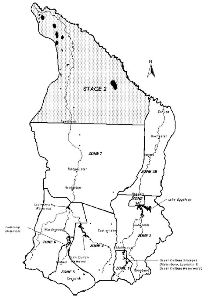 Figure 2: Scope of the BRFMP, showing designated management zones as described in Table 2.
A number of both native and introduced fish species are targeted by anglers within the management zones covered by this BRFMP. The vast majority of waters contain at least two angling species and it can be generally said that the majority of waters will be managed as multi-species waters. The available habitat will dictate which species occur naturally and which species may need to be stocked to help maintain a recreational fishery.
Table 3: Angling species present in major waters within the management zones for the BRFMP.
| Zone | Waterway | BT | CC | RF | RT | BF | CF | GP | MC | MP |
|---|---|---|---|---|---|---|---|---|---|---|
| 1 | Lauriston Reservoir Malmsbury Reservoir Upper Coliban Reservoir Upper Coliban Reservoir |
X X X X |
X |
X X X |
X |
X |
||||
| 2 | Upper Campaspe Reservoir Lower Coliban Reservoir Eppalock Lake |
X X X |
X X |
X X X |
X |
X |
X |
|||
| 3A | Campaspe River above Axedale | X | X | |||||||
| 3B | Campaspe River below Axedale | X | X | X | ||||||
| 4 | Barkers Creek. Reservoir Bullarto Reservoir Cairn Curran Reservoir Daylesford Lake Expedition Pass Reservoir Jim Crow Creek Jubilee Lake Loddon River above Cairn Curran. Wombat Creek. Reservoir |
X X X X X X |
X X X X X X X X |
X |
X X X |
X X X |
||||
| 5 | Birch Creek Cosgrove Reservoir Creswick Creek Dean Reservoir Hepburn Lagoon Newlyn Reservoir St. Georges Lake Tullaroop Creek Tullaroop Reservoir |
X X X X X X X X |
X X X X X X X X X |
X X X |
X X X |
X |
||||
| 6 | Bet Bet Creek Deep CreeK Goldfield Reservoir Laanecoorie Reservoir Loddon River below Cairn Curran Talbot Reservoir Victoria Lake |
X X |
X |
X X X X X X |
X X |
X X X X X |
X X |
|||
| 7 | Crusoe Reservoir Kennington Reservoir Loddon River below Laanecoorie Serpentine Creek |
X X |
X X X X |
X |
X X |
X |
| Fish Species Legend | ||
| BT - Brown trout CC - Carp RF - Redfin |
RT - Rainbow trout BF - Blackfish CF - Freshwater catfish |
GP - Golden perch MC - Murray cod MP - Macquarie perch |
The size of the area covered by the BRFMP, and the diversity of waters included are such that it is not feasible to prescribe management arrangements for all waters at once. Rather, it is more practical to address the management requirements of major fisheries in the area as a matter of priority, and to address the management of other waters as an ongoing process.
Angler response during the public consultation phase for the BRFMP suggested that the majority of angler effort in the Bendigo region focused on the larger, better known fisheries. For this reason, the BRFMP gives priority to the following waters:
- the Upper Coliban storages (Upper Coliban Reservoir, Lauriston Reservoir and Malmsbury Reservoir)
- Lake Eppalock
- the Campaspe River from the outflow of Lake Eppalock to Echuca
- Cairn Curran Reservoir
- Barkers Creek Reservoir
- Jim Crow Creek
- the Loddon River from the outflow of Laanecoorie Reservoir to Bridgewater
- Tullaroop Reservoir
This list is by no means inclusive of the whole the BRFMP, however it provides some reasonable targets for its initial implementation and will pave the way for further management arrangements for other identified fisheries in the Bendigo region.
4.1 Upper Coliban River Storages (Zone 1)
The Upper Coliban Reservoir, Lauriston Reservoir and Malmsbury Reservoir are situated in a series along the Upper Coliban River with short stretches of the Coliban River separating the storages.
The Upper Coliban Reservoir is the largest of the three with a capacity of 37 500 ML, a surface area of 340 ha at full supply level and a catchment area of 192 km². Initially built in 1903, it was upgraded and enlarged in 1993 whena further two metres were added to the wall.
The reservoir has few shallow zones and relatively steep banks that exhibit little riparian vegetation. Surrounding land has been extensively cleared for grazing.
Water is released through two 730 mm diameter low level outlets. The Upper Coliban Reservoir is usually the first of the three reservoirs to be drawn down, usually to a greater extent than the remaining two reservoirs.
Lauriston Reservoir was constructed in 1941. The dam is a 33 m high buttress and slab concrete structure. It has a capacity of almost 20 000 ML and a surface area at full capacity of 208 ha. The reservoir has a catchment area of about 223 km², with the immediate area around the dam wall forming the primary recreational focus for Coliban Water.
Surrounded by grazing land, the storage hasrelatively few shallow areas, with exposedbanks and minimal riparian vegetation. Wateris released via two 750 mm diameter low leveloutlets or the nine spillway gates.
Malmsbury Reservoir, built in 1870, is one of the oldest storages in the area and parts of the structure and outlet works are heritage listed. Adjacent land use is predominantly grazing.
With an 18 m earthfill embankment, Malmsbury Reservoir has a capacity of 18 000 ML, a surface area of 301 ha at full supply level, and a catchment area of 290 km2. Water is released via a 1200 mm diameter low level outlet.
Based on the results of fish surveys conducted by NRE over many years, Malmsbury Reservoir is considered the most productive of the three upper Coliban storages, due to its extensive shallow areas and weedy margins (Tunbridge, Rogan & Barnham, 1991). Aquatic vegetation is particularly thick in the upper reaches of the impoundment (Douglas, 1998).
4.1.1 Water management
Coliban Water owns and maintains the three impoundments as urban supply storages, comprising the bulk of the Coliban Water Supply System, which supplies 14 towns throughout the region including Bendigo and Castlemaine. Coliban Water also manages the short stretches of the Coliban River linking the three storages.
The storages are essentially operated as one functional unit. During winter-spring the storages fill to capacity in most years. As demands are met, Lauriston Reservoir is drawn down 0.5 m in order to minimise bank erosion. Malmsbury Reservoir is drawn down next by 2-4 m, creating storage space of sufficient size to store tributary inflows that may eventuate from summer thunderstorms. Once the drawdown targets for Lauriston and Malmsbury reservoirs are reached, Upper Coliban Reservoir is used to meet further demand as far as is practical.
The 1999 Bulk Entitlement Conversion Order for the Campaspe system stipulates that Coliban Water must maintain a passing flow of 8 ML per day, or the natural inflow (whichever is lower), in the Coliban River immediately below Malmsbury Reservoir. The Malmsbury Reservoir releases 33 200 ML of water annually into the lower Coliban River, and has some inflow from James and Myrtle Creeks (Bennett, 1991).
4.1.2 Access and facilities
The Upper Coliban Reservoir has a recreational area situated along the lower section of the spillway chute. Due to the condition of the facilities, vandalism and relatively low visitor numbers, this area has a low priority for maintenance and improvement. The storage is a major component of the Coliban Supply System and is used to supply rural and urban demands. Fishing is permitted but not swimming or boating.
Lauriston Reservoir is an urban water supply storage, hence boating and swimming are prohibited. However bank fishing is permitted. The reservoir is open from 8.00a.m, until dusk, seven days a week, and a tollgate fee applies. Visitor amenities include barbecues, playground equipment, parking and sealed roadways, rubbish bins and toilet facilities with disabled access.
A recreational area is located at the Malmsbury reservoir. Facilities include a toilet block and barbecue. Fishing is permitted but not boating or swimming.
4.1.3 Environmental issues
- Environmental issues of the Upper Coliban River storages include that:
- Introduced flora threatens biodiversity along the upper Coliban River and between storages by overrunning native species and preventing regeneration.
- Low level releases from the three storages results in cold, deoxygenated water entering the Coliban River immediately downstream of the reservoirs. Few indigenous species can survive and prosper in this type of environment.
- There is unrestricted stock access.
- Carp recently introduced into the UpperColiban Reservoir are likely to have spread into the Lauriston and Malmsbury reservoirs via flood events.
4.1.4 Current status of the fishery
The dominant fish species within zone 1 are redfin and brown trout, with some waterways hosting self-supporting populations. Best fishing is recorded when the water level is low.
The Upper Coliban Reservoir is classed as a mixed species fishery primarily (Macquarie perch, trout and redfin primarily) and is managed accordingly. The dam is one of only three waters in Victoria where anglers may target and take Macquarie Perch. Between 1994 and 1997 nearly 85 000 Macquarie perch were stocked into the upper Coliban River with the aim of providing a recreational fishery.
The Upper Coliban Reservoir is an established brown trout fishery, and has been stocked by NRE since 1941. Tunbridge, Rogan & Barnham (1991) suggested that some trout migrate into the Coliban River above the storage to spawn. Although the trout population is not considered to be self-supporting, some natural recruitment occurs (Douglas, Brown & Strongman 1998). Results of a 1998 MAFRI fisheries assessment are summarised in Table 4.
Table 4: Catch summary of the 1998 MAFRI survey for the Upper Coliban Reservoir, showing major angling species caught, mean length and mean weight.
| Species | No. caught | Mean length (mm) | Mean weight (g) |
| Brown trout | 48 | 395 | 785 |
| Macquarie perch | 15 | 275 | 400 |
| Redfin | 43 | 237 | 356 |
| Roach | 3 | 220 | 180 |
| Chinook salmon | 1 | 330 | 500 |
| Australian smelt | 4 | 56 | 1 |
There are specific bag and size limits on recreational fishing within the Upper Coliban Reservoir; these are outlined in the Victorian Recreational Fishing Guide, 2001-2002 (NRE, 2001).
Carp were illegally introduced into the storage. This is an offence under Section 76 of the Fisheries Act 1995 and carries a penalty of up to $10 000 for the first offence. It is also an offence to use live carp, including goldfish, as bait.
Classed as a mixed species (salmonids and redfin) fishery, Lauriston Reservoir is currently stocked regularly with brown trout by NRE. This is a popular angling water for both brown trout and redfin. Results of a 1998 MAFRI survey on Lauriston Reservoir are summarised in Table 5 (Brown, 1998c).
Table 5: Catch summary of the 1998 MAFRI survey for Lauriston Reservoir, showing species caught, mean length and mean weight.
| Species | No. caught | Mean length (mm) | Mean weight (g) |
| Brown trout | 29 | 372 | 597 |
| Redfin | 24 | 236 | 321 |
| Roach | 22 | 227 | 208 |
Although carp have not yet been recorded in the Lauriston Reservoir, recent floods (October 2000) suggest their presence, coupled with their presence in the Upper Coliban Reservoir.
Malmsbury Reservoir is classed as a mixed species (salmonids and redfin) fishery, and is a popular brown trout and redfin angling water. Brown trout and redfin averaging 1 kg (2.8 kg maximum) and 350 g (1.2 kg maximum) respectively are common, and tench up to 2 kg and goldfish are also reported (Tunbridge, Rogan & Barnham, 1991).
Malmsbury Reservoir has been stocked with rainbow trout and brown trout since its completion in 1870. Rainbow trout were last stocked in 1964 since then the reservoir has been managed as a brown trout fishery with regular NRE stockings.
A 1998 fisheries assessment concluded that the reservoir produces quality trout for recreational fishers. The results of this survey for the major angling species are summarised in Table 6.
Table 6: Catch summary of the 1998 MAFRI survey for Malmsbury Reservoir, showing major angling species caught, mean length and mean weight. (Source Douglas, 1998)
| Species | Mean length (mm) | Mean weight (g) |
| Brown trout | 394 | 750 |
| Redfin | 333 | 719 |
| Tench | 334 | 611 |
| Goldfish | 258 | 486 |
The survey confirmed the dominance of trout in the reservoir and that anglers had access to large (>30 cm) well conditioned fish (Douglas, 1998).
Carp have not yet been recorded in Malmsbury Reservoir, although flood events coupled with their presence in the Upper Coliban Reservoir suggest that their presence is likely.
Very good fishing is reported when the storage is rising, with fish moving onto the newly covered shallow margins to feed on terrestrial insects and other invertebrates.
4.1.5 Specific fisheries management strategies and actions
Strategy 22
Continue to manage the Upper Coliban storages as a mixed species fishery
Action 22.1
Maintain and enhance the stocked Macquarie perch population in the Upper Coliban Reservoir.
Action 22.2
Maintain the existing self-sustaining redfin population.
Action 22.3
Continue NRE's 'ten waters trout stocking program' in Lauriston and Malmsbury reservoirs.
Action 22.4
Continue existing management of trout in the Upper Coliban, Lauriston and Malmsbury reservoirs. Stock brown trout regularly, numbers being dependent on existing environmental conditions including water level.
Action 22.5
Monitor the recently introduced carp stocks in the Upper Coliban Reservoir, and potentially Lauriston and Malmsbury reservoirs.
Strategy 23
Maintain the Macquarie perch fishery
Action 23.1
Maintain and enhance the Macquarie perch population in the Upper Coliban Reservoir by regular stocking.
Action 23.2
Actively encourage anglers to recognise the conservation status of this species and comply with fishing regulations.
4.2 Lake Eppalock (Zone 2)
Located approximately 25 km from the centre of Bendigo, Lake Eppalock is a multi-use storage, and at 3,230 ha and 312 000 ML at full supply level is regarded as central Victoria's premier recreational waterway.
The lake has a total catchment area of 2 124 km² with its major feeder streams, the Coliban and Campaspe Rivers and Wild Duck and McIvor Creeks, resulting in a mean annual inflow of approximately 222 200 ML.
The primary land uses surrounding the storage are broadacre cropping and grazing. Some red gum woodlands exist along the eastern-most banks, although generally riparian tree cover is sparse. The lake has a good ratio of deep to shallow waters, and inflow of nutrients washed from surrounding agricultural land makes the lake relatively productive. Summer water temperatures are warm.
4.2.1 Water management
The primary purpose of Lake Eppalock is to supply irrigation water. However water is also extracted as part of the Coliban Water Supply System and as urban supply for the township of Heathcote.
Lake Eppalock is owned and managed by Goulburn-Murray Water. Goulburn-Murray Water are currently developing a Recreation Development Strategy for Lake Eppalock, which will complement the BRFMP.
A 28 km pipeline supplies water from Lake Eppalock to urban storages in Bendigo, forming part of the Coliban Water Supply System. The total regulated output from Lake Eppalock is estimated at 100 400 ML per annum.
A pumping station at Lake Eppalock delivers chlorinated water via a 24 km pipeline to the 320 ML capacity Caledonia Reservoir where it serves as an urban supply for the township of Heathcote.
Several other private and urban diversions exist throughout the Eppalock supply system.
The Bulk Entitlement Conversion Order 1999 (Vic) stipulates that passing flows must be maintained in the Campaspe River below Lake Eppalock. The volume of these flows varies with available water and season.
4.2.2 Access and Facilities
The main entrance to the Lake Eppalock foreshore is 25 km from the centre of Bendigo. Fishing, boating, waterskiing, jetskiing, swimming and sailing are all permitted. Accommodation is also available at caravan parks and a hotel/motel. There are many picnic and barbecue facilities surrounding the lake.
4.2.3 Environmental issues
Environmental issues of Lake Eppalock include:
- Water quality.
- Power boating and swimming are permitted in Lake Eppalock but are of some concern, as the lake is also used as a domestic water supply.
- Shoreline erosion contributes to the turbidity of the lake, reducing light penetration and thus productivity. Increased sedimentation on the lake floor is also a consequence.
- Carp populations in Lake Eppalock are very high.
- Loss of fish habitat (fallen timber and stumps) through its removal for firewood etc.
- Goulburn-Murray Water are currently developing storage perimeter policies to address uncontrolled stock access to storages.
4.2.4 Current status of the fishery
Lake Eppalock is managed as a mixed species fishery (primarily redfin and native fish).
A recent fisheries assessment (MAFRI, 2000b) was conducted by MAFRI in September 2000. Results of this survey are summarised below.
NRE stockings of golden perch commenced in 1991 and have been ongoing since. A number of private stockings have also taken place under permit.
Murray cod have also been stocked into the Campaspe arm upstream of Metcalfe Pool since the early 1990s. Occasional angling reports of cod were confirmed by a fisheries assessment in 1998 when 2 cod were caught (Brown, 1998b).
Occasional rainbow trout and brown trout up to 3.3 kg are reported, however brown trout have not been stocked into the lake since 1979 nor have rainbow trout since 1978 due to poor returns from major releases (Tunbridge, Rogan & Barnham, 1991). In 1978 approximately 27 000 brown trout and 84 000 rainbow trout were released, and a further 15 000 brown trout were released in 1979 (Barnham, 2001).
The best fishing times for redfin in Lake Eppalock are reported between December to May and from April to June for trout at the mouth of Wild Duck Creek, providing there is sufficient flow (Tunbridge, Rogan & Barnham, 1991).
An area of consideration for the Lake Eppalock fishery, is that its popularity as a recreational angling water is increasing.
Table 7: Summary of results obtained from the 2000 Fisheries Assessment of Lake Eppalock, (Source: MAFRI. 2000b), showing location, mean weight and number of each species caught.
| Site | Species | No. caught | Mean length (mm) | Mean weight (g) |
| Metcalfe Pool | Golden perch Carp |
10 7 |
334 456 |
607 2074 |
| Kimbolten Pool | Golden perch Carp Redfin |
82 24 14 |
370 395 347 |
970 1253 767 |
Angling pressure is increasing over a longer period, with anglers targeting golden perch during the warmer summer months previously dominated by redfin fishing.
Between 1991 and 1994 trout cod were stocked in the Coliban River upstream of Lake Eppalock. There are no stock assessments or anecdotal angler reports to suggest that these stockings were successful.
The potential exists for the introduction of artificial structures into Lake Eppalock to compensate for fluctuating water levels and to provide improved habitat for stocked Murray cod. This may also enhance the likelihood of breeding and allow shore-based anglers to target this species.
4.2.5 Specific fisheries management strategies and actions
Strategy 24
Continue to manage Lake Eppalock as a high use, mixed species fishery
Action 24.1
Continue to provide opportunities to use all aspects of the fishery.
Action 24.2
Maintain and enhance the stocked golden perch and Murray cod populations.
Action 24.3
Manage the fisheries based on self-sustaining brown trout and redfin populations.
Action 24.4
Recognise angler interest in the wild selfsustaining redfin fishery within Lake Eppalock.
Strategy 25
Provide an abundance of quality fish habitat in Lake Eppalock
Action 25.1
Protect existing fish habitat in Lake Eppalockand enhance where practicable.
Action 25.2
Promote spawning and artificial habitat utilisation by Murray cod population at varying water levels.
Strategy 26
Promote angler access for shore and boat based fishing on the lake
Action 26.1
Provide access to the lake to allow anglers to fish a range of locations, and provide adequate facilities to accommodate high visitation rates without compromising environmental values.
Action 26.2
Identify areas of importance to anglers and endeavour to maintain current levels of access.
Action 26.3
Upgrade facilities at high-use access points. Possible improvements may include cleaning tables, lighting and so on.
Action 26.4
Assess sites with potential for development for use by disabled/ junior/elderly anglers.
4.3 Campaspe River (Lake Eppalock - Echuca) (Zones 3A & 3B)
Between Lake Eppalock and Axedale the Campaspe River is of slow to medium flow with well-defined riffles, runs and pools around Axedale. The stream bed is composed of gravel with a light coating of silt. Undercut banks, overhanging and instream vegetation, woody debris, deep pools, root wads and mats, and shallow margins provide habitat for fish and other aquatic animals along this stretch of the river (NCCMA, 2000).
The width of the riparian zone along this stretch of the Campaspe River is generally between 10 and 40 m and the vegetation is comprised largely of native species. Land adjacent to the river is predominantly used for grazing, with some residential settlements. Stock have uncontrolled access to the river in some places.
The river is of medium flow in the area from Axedale to the Elmore Weir, with a distinct transition between well-developed riffles and pools of varying depth and a streambed is composed of gravels.
A weir located at Elmore regulates the Campaspe's flow for irrigation. The weir pool is mud bottomed and surrounded by open country. Below the Elmore Weir, the river demonstrates pooled flow, with poorly developed or absent riffles, and pools of varying depth. The streambed is composed ofsand and extensive silt beds.
The Campaspe Weir at Elmore and the Campaspe Siphon downstream from Rochester regulate the river from Elmore to Echuca. The Waranga Western Main Channel (WWC) crosses the Campaspe River north of Rochester. This channel brings water from the Goulburn River catchment and, if required, can pick up a further 500 ML per day from the Campaspe River.
The riparian zone is generally between 10 and 40 m wide, but as the Campaspe River approaches the Murray River the riparian vegetation is often over 40 m wide. This riparian vegetation is comprised almost entirely of native species, notably river red gum of various ages.
The predominant land use is grazing, with uncontrolled stock access to the river along most of its length. Bank erosion affects the length of the river.
Habitat for fish and other aquatic animals is excellent, with undercut banks, shallow margins and deep pools, overhanging and instream vegetation, extensive woody debris, and root wads found throughout the entire length of the river. Water quality deteriorates below the Elmore Weir, due to high turbidity.
The Campaspe River near Axedale is moderately meandering, increasing as the river moves toward the Murray.
Flood events are rare, due to the highly regulated nature of the Campaspe River. However, during flood the river breaks out below Rochester and spreads out over a floodplain about six km wide for a distance of about 20 km downstream to Echuca.
Typically the depth and velocity of flow of a flood are relatively low and last for one or two days. Roads, railway lines, water supply channels and drains complicate the flood pattern.
4.3.1 Water management
The mean annual discharge to the Campaspe River from Lake Eppalock is 209 500 ML. This figure does not include the 14 800 ML diverted into the Coliban Water Supply System (Bennett, 1991). There is a minimum flow of 0-10 ML per day that is dependent on seasonal conditions, extent of diversion and tributary flows. There is also no restriction on the rise and fall of the Campaspe River below Lake Eppalock, the reason being to limit potential losses resulting from rapid changes in water downstream. This means that a sudden decrease in demand during heavy rains must be balanced with a sudden decrease in supply, or water will be lost over the Campaspe Weir.
In 1999 a review of the bulk water allocationfor the Campaspe River was completed, with allocation for an environmental flow in the Campaspe River below Lake Eppalock.
The primary consumers of water released from Lake Eppalock are irrigators in the Campaspe Irrigation District, approximately 60 km north of the lake around the township of Rochester. Water is also supplied to irrigators and private diverters on the Campaspe River and into the WWC at Rochester.
The Campaspe Weir located on the Campaspe River between Elmore and Rochester supplies water to the Campaspe Irrigation District. The Rochester Irrigation Area extends north from the WWC to the Murray River and covers an area of 75 900 ha.
Water that is not diverted to the Campaspe Irrigation District by the weir is utilised by private diverters below the weir and by the WWC. The Campaspe Siphon Pumps may drive up to 500 ML per day into the channel, where the water serves to increase the peak flow to the Deakin, Rochester, Pyramid Hill and Boort areas.
Irrigation water is diverted between 15 August and 15 May, with little water usually required early in the season.
A pumping station located on the Campaspe River supplies the townships of Axedale and Goornong. The annual consumption of Goornong is 117 ML.
Rochester township draws water from the WWC for urban supply. When the channel is not flowing, urban requirements are met by pumping from the Campaspe River. The water entitlement for these purposes is not specified other than the right to take sufficient water for the town's needs (Bennett, 1991).
4.3.2 Access and facilities
Access to the river is mainly through private property and permission should be sought from the landowner.
Boating is permitted throughout the river. However boat access is difficult except for the backed up water above the Campaspe Weir between Elmore and Rochester.
4.3.3 Environmental issues
Environmental issues of the Campaspe River include:
- Excess silt and dust runoff from the quarry on the eastern bank that may affect water quality.
- Uncontrolled stock access.
- Low water levels below the Campaspe Weir.
- Agricultural litter entering the river.
- Carp infestation.
- 'Fish kill' events that result from poor water quality associated with heavy localised rainfall.
- Barriers to fish passage.
- Low water temperature.
4.3.4 Current status of the fishery
The stretch of river from Lake Eppalock to Axedale is managed as a self-sustaining 'wild' brown trout stream. This section of river was last stocked by NRE in 1979 (with the exception of a small trial release of specially fin-clipped fish in 1990). Angler reports suggest redfin and small golden perch also occur, although the release of cold water from the low level off-take at Lake Eppalock will restrict the establishment of 'warm' water species immediately below the dam.
Between Axedale and Elmore, the Campaspe River is managed as a mixed species fishery, with occasional brown trout, redfin and small golden perch. Murray cod were stocked by NRE between 1988 and 1991. No further NRE stockings have occurred, due to inadequate flow (Tunbridge, Rogan & Barnham, 1991). NRE stockings of brown trout into this section of the river continued until 1979.
The Elmore Weir pool is regarded as one of the best fishing areas along the Campaspe River. Golden perch and Murray cod have recently been stocked by NRE with reports suggesting that a successful fishery has been established. Redfin and occasional brown trout are also reported. Brown trout were last stocked into the weir in 1981 (Tunbridge, Rogan & Barnham, 1991).
NRE released Murray cod into the Campaspe River at Rochester early in 2001, but does not regularly stock the river below Elmore, primarily due to lack of fish habitat. The Rochester Angling Club has also stocked Murray cod at Rochester. This stretch of the river is managed as a native species fishery, with golden perch and Murray cod the target angling species.
The Campaspe River below Lake Eppalock also contains self-supporting populations of common carp, goldfish and tench throughout its length.
The river between Axedale and Echuca is not ranked highly on NRE priority lists for recreational fish stockings. Although this stretch of the Campaspe River features Murray cod and golden perch, in the form of woody debris, deep pools and riparian vegetation, the heavily regulated nature of the river provides insufficient flows to support healthy fish communities.
An ongoing assessment of fish communities in the Campaspe River, conducted by the Cooperative Research Centre for Freshwater Ecology and MAFRI, indicates that the golden perch and Murray cod populations are not breeding successfully, and that to date the fishery is reliant on stockings for its survival.
4.3.5 Specific fisheries management strategies and actions
Strategy 27
Provide a range of fishing opportunities in the Campaspe River below Lake Eppalock
Action 27.1
Maintain and enhance the wild and stocked native fish fisheries throughout the Campaspe River.
Action 27.2
Maintain the existing wild brown trout tailrace fishery immediately below Lake Eppalock and minimise disturbances to spawning fish.
Action 27.3
Recognise angler interest in the wild selfsustaining redfin fishery throughout the Campaspe River.
Strategy 28
Provide environmental flows that as far as possible mimic the natural flow regime of the Campaspe River
Action 28.1
Support the development of operational changes to regulated releases from Lake Eppalock as described in the NCCMA's Investigation of Aquatic Ecosystems of the Campaspe Catchment (McGuckin & Doeg, 2001).
Action 28.2
Specify environmental flows needed to improve existing aquatic habitat.
Action 28.3
Examine the potential for water savings within the irrigation and domestic distribution systems as described in the NCCMA's Investigation of Aquatic Ecosystems of the Campaspe Catchment (McGuckin & Doeg, 2001).
Action 28.4
Determine and promote water management strategies that maximise survival and growth of recently recruited or released trout, redfin and native fish.
Strategy 29
Promote free fish movements throughout the Campaspe River
Action 29.1
Encourage the installation of a fishway at the Echuca Weir (and subsequent fishways on the Campaspe Siphon and Campaspe Weir).
Action 29.2
Encourage any future structures on the Campaspe River to incorporate a fishway into initial construction plans as a priority action.
Action 29.3
Promote the importance of aligning environmental flows, water temperatures and fishways.
Strategy 30
Reduce levels of pollution and rubbish in the Campaspe River from agricultural practices
Action 30.1
Encourage land and riparian revegetation programs to reduce runoff from agricultural land, and avoid mass sediment deposition.
Action 30.2
Encourage landowners to adopt responsible farm practices in the disposal of rubbish, particularly adjacent to the Campaspe River and its tributaries.
4.4 Cairn Curran Reservoir (Zone 4)
Cairn Curran Reservoir was formed by the impoundment of the Loddon River and its tributaries below Newstead, and has a capacity of 148 000 ML, a catchment encompassing 1 593 km², and a surface area of 1 900 ha at full storage level. The reservoir has a mud bottom, and is surrounded by grazing land, with the shoreline largely bare of riparian vegetation. The reservoir has extensive shallows and abundant aquatic vegetation at the southern end; it also experiences large fluctuations in water level.
4.4.1 Water management
Cairn Curran Reservoir's major function is to provide irrigation water for the Loddon River Irrigation system, and the western half of the Goulburn-Murray Irrigation District.
4.4.2 Access and Facilities
Cairn Curran Reservoir is a very accessible multi-use waterbody. Boating, swimming and fishing are all permitted activities on and around the Reservoir. Camping and extensive picnic and recreational areas are located at Welshmans Reef on the northern end of the lake, along with a boat ramp. Boat ramps are also located at Woolshed Bay and Letheridge Bay.
4.4.3 Environmental issues
Environmental issues of Cairn Curran Reservoir include:
- Poor or absent riparian vegetation around the storage.
- Uncontrolled stock access.
- Poor water quality, particularly blue-green algal blooms.
- Pollution associated with power boating and human activity on the storage.
- Goulburn-Murray Water are currently developing storage perimeter policies to address uncontrolled stock access to storages.
4.4.4 Current status of the fishery
Managed as a mixed species fishery, Cairn Curran Reservoir supports year round angling, with established brown trout, redfin and native species populations.
NRE first stocked brown trout into Cairn Curran Reservoir in 1960. Rainbow trout were stocked from 1961 until 1970. Brown trout stockings resumed in 1973 and they have been regularly stocked since then.
More recently the decision was made to manage the reservoir as a mixed species fishery for both native and introduced species of fish. Golden perch and Murray cod were first released into Cairn Curran Reservoir by NRE in 1994-1995, and have been regularly stocked since then.
Results of a 1998 MAFRI fisheries assessment are summarised in Table 8.
Table 8: Summary of results of the 1998 MAFRI survey, showing major angling species caught, and mean lengths and weights (Source: Brown, 1998a).
| Species | Mean length (mm) | Mean weight (g) |
| Golden perch | 443 | 2016 |
| Brown trout | 457 | 1389 |
| Redfin | 343 | 889 |
| Tench | 364 | 776 |
| Goldfish | 243 | 359 |
The survey showed that golden perch were in excellent condition and were heavier than average for their length. The golden perch sampled were likely to have been from the 1994 - 1995 stocking (Brown, 1998a). Brown trout were generally in good condition (ranging from fair to excellent). Murray cod were not recorded during this survey, but anecdotal reports of angling captures suggest that this species has survived in small numbers.
Under the current salmonid fishing regulations for Victoria, anglers fishing Cairn Curran Reservoir can take up to 10 trout a day, of which no more than five may be under 30 cm in length.
Winter and spring are the best times to target brown trout in this waterway, whilst late summer is the optimum time for targeting redfin (Tunbridge, Rogan & Barnham, 1991). Holders of a Victorian Recreational Fishing Licence (or persons otherwise exempt) are permitted to use a 6 m bait net within the reservoir.
The potential exists for the introduction of artificial structures into Cairn Curran Reservoir to compensate for fluctuating water levels and to provide improved habitat for stocked Murray cod. This may also enhance the likelihood of breeding and allow shorebased anglers to target this species.
4.4.5 Specific fisheries management strategies and actions
Strategy 31
Manage Cairn Curran Reservoir as a high use, mixed species fishery
Action 31.1
Continue to provide opportunities to use all aspects of the fishery.
Action 31.2
Maintain the self-sustaining and stocked brown trout population.
Action 31.3
Maintain and enhance the stocked golden perch and Murray cod populations.
Action 31.4
Recognise angler interest in the wild selfsustaining redfin fishery in Cairn Curran Reservoir.
Action 31.5
Maintain bag limits on yabbies and monitor angler catches.
Strategy 32
Maintain quality fish habitat in Cairn Curran Reservoir
Action 32.1
Protect existing fish habitat in Cairn Curran Reservoir.
Action 32.2
Explore the potential for the introduction of artificial structures into Cairn Curran Reservoir to provide improved habitat for stocked Murray cod and to enhance the likelihood of breeding.
Strategy 33
Provide suficient access to the lake to allow anglers to fish a range of locations, and provide adequate facilities to accommodate high visitation rates without compromising environmental values
Action 33.1
Recognise areas of importance to anglers and endeavour to maintain current levels of access.
Action 33.2
Upgrade facilities at high-use access points. Possible improvements include cleaning tables, lighting and so on.
Action 33.3
Consider potential sites that could be developed for use by disabled/junior/elderly anglers.
4.5 Jim Crow Creek (Zone 4)
This small, fast flowing stream flows into the Loddon River above Cairn Curran Reservoir. The stream has a gravel and cobble substrate, well-defined riffles and deep pools. Instream habitat is abundant, with woody debris, instream vegetation (such as reeds), large rocks, shallow margins and deep pools. Banks are undercut, and riparian vegetation is continuous and overhanging.
The major land use adjacent to the stream is grazing. Stock access is controlled for the majority of the stream with banks fully fenced, however some stock access in the mid-sections has resulted in trampled banks and visible algal blooms probably due to nutrient influx. Some mild bank erosion exists in the upper reaches, whilst the lower regions experience more severe erosion of 50–75% and greater (NCCMA, 2000).
4.5.1 Water management
Jim Crow Creek is largely unregulated, with the exception of several small weirs.
4.5.2 Access and facilities
Access is generally good, however above the weir at Yandoit the stream flows through private property, and hence permission for access should be sought from the landowner. Dense introduced riparian vegetation such as gorse and blackberry presents some access problems.
4.5.3 Environmental issues
Environmental issues of the Jim Crow Creek include:
- Introduced pest species such as gorse, blackberry, fennel, cape brown and spiny rush growing thickly along the riparian zone of Jim Crow Creek, restricting access to the stream, and preventing establishment of native vegetation. However, excellent water quality may be partially attributed to this thick riparian zone as land adjacent to the creek is cleared and used for grazing, with some sections unfenced. If the pest plants were to be removed, stock access and subsequent water quality problems may present a far more serious issue.
- It should be noted that unless adequate controls such as fencing and large-scale revegetation programs are in place, removal of these introduced species may be detrimental to the fishery.
- Willow infestation altering stream morphology and preventing establishment of native vegetation.
- Excessive blackberry growth.
4.5.4 Current status of the fishery:
The stream holds a self-supporting population of brown trout, supplemented by fish migrating from Cairn Curran Reservoir via the Loddon River. The stream is believed to serve as an important nursery stream for Cairn Curran Reservoir.
Trout are most abundant above the Loddon junction, where the stream is regarded as one of the best trout waters in the basin, due to high numbers of fish. Summer flows are known to affect fish stocks, and the large number of fish present results in poor growth rate and stunted fish. This waterway was last stocked with brown trout by NRE in 1958.
4.5.5 Specific fisheries management strategies and actions
Strategy 34
Manage Jim Crow Creek as a self-sustaining brown trout creek
Action 34.11
Minimise interference with spawning trout.
Strategy 35
Provide quality habitat and water quality for a self-sustaining population of brown trout in Jim Crow Creek and minimise disturbances
Action 35.1
Control stock access to the stream.
Action 35.2
Continue to control blackberry and willow, and ensure that adequate follow up procedures are adopted to prevent re-establishment.
Note
Removal of hostile pest plant species such as gorse from the banks of the creek should not be attempted unless resources are available for mass revegetation and exclusion of stock.
4.6 Barkers Creek Reservoir (Zone 4)
The Barkers Creek Reservoir is often incorrectly referred to as the Harcourt (North) Reservoir. This 58 ha domestic water supply reservoir comprises a 13 m high earthfill embankment and a 900 mm-diameter cast iron outlet. The embankment and outlet tower were built in 1869 and are heritage listed.
The lake has a silt/sand substrate with large amounts of organic matter, and is fed by Barkers Creek, which reforms at the outflow and passes through the towns of Harcourt and Castlemaine before feeding into the Loddon River. The reservoir once had a maximum depth of about 15 m, however dam safety issues have resulted in the maximum water level being reduced to 14.2 m.
Major land uses around the impoundment are grazing, orchards and low density residential development. Water within the reservoir is very clear with noticeable tannin colouration.
Shallow margins with abundant weed growth are extensive, and a good stand of river red gums surrounds the lake. Stands of common reed inhabit the margins and there is an abundance of woody debris where Barkers Creek flows into the lake; the reservoir also has extensive aquatic weed growth.
The creek downstream of the reservoir serves as an important fishery for junior anglers.
4.6.1 Water management
Barkers Creek Reservoir, constructed in 1869, is owned and managed by Coliban Water.
The capacity of Barkers Creek Reservoir is greater than Coliban Water requires for water supply purposes. As an initial response to dam safety concerns the storage has been permanently lowered by the removal of boards from the spillway. The new capacity is 2 250 ML, down from 2 690 ML. Options for upgrading will consider further lowering.
This reservoir is currently a high priority for upgrading due to its age and construction, which is no longer meets current standards.
Detailed investigations are being undertaken on ten storages, including Barkers Creek Reservoir, to finalise works priorities for a major dams improvement program. At this time it is expected that Barkers Creek will remain a high priority for upgrading with works likely to commence in the winter of 2002. The storage may be lowered to almost empty for construction works, however it is expected that decisions will not be finalised until at least early 2002.
4.6.2 Access and facilities
Access to the car park is off a bend in the main road through Harcourt North. Care should be taken as the entrance is narrow, signage is poor and there is no entry lane.
Swimming, boating and camping are prohibited activities at the storage; bank fishing is allowed. The storage is probably too small to consider general boating and there are no facilities for camping. The storage has an unsealed car park and access track, a toilet block, rubbish collection and a water supply.
4.6.3 Environmental Issues
Environmental issues of Barkers Creek Reservoir include:
- Spray drift and runoff from adjacent orchards may result in pesticides/fertilisers entering the fishery.
- Proposed lowering of the reservoir by 2-4 m may have an effect on the recreational fishery both within the reservoir and on fisheries downstream.
4.6.4 Current status of the fishery
Barkers Creek Reservoir is managed as a mixed species fishery and contains abundant brown trout, rainbow trout and redfin. Goldfish and tench are also present. The storage has been regularly stocked with brown trout by NRE.
A decision to significantly lower the water level for works in 2001 resulted in the stocking plan switching from brown trout to rainbow trout for 2000 to maximise the capture of trout and minimise wastage of stocked fish before the reservoir was drawn down/drained in 2001. Rainbow trout are a shorter lived species than brown trout, and considered easier to catch.
Fisheries Victoria will not undertake a fish recovery or relocation, because the reservoir is a mixed species (brown trout/redfin) fishery and has no FFG listed species present. The Fisheries Victoria-VRFish Fish Recovery Protocol developed by Fisheries Victoria and endorsed by the NRE regions and VRFish specifies that fish recoveries will target only FFG-listed species but other fish species may be collected as by catch.
A fisheries assessment conducted by MAFRI (Hall, 2000a) concluded that Barkers Creek Reservoir supports a stocked population of healthy trout surviving up to 5 years of age, and is of fair condition for recreational angling. The results of the survey are summarised in Table 9.
Table 9: Summary of 2000 MAFRI survey on Barkers Creek Reservoir, showing species caught, and mean lengths and weights (Source: Hall, 2000a).
| Species | No. Caught | Mean length (mm) | Mean weight (g) |
| Brown trout | 46 | 344 | 501 |
| Redfin | 66 | 268 | 398 |
| Tench | 1 | 550 | 2583 |
| Goldfish | 1 | 280 | 79 |
| Flatheaded gudgeon | 2 | 781 | 6 |
The quality of fishing within the reservoir has improved in recent years (in particular the numbers of fish caught). This improvement may be attributed to higher average water levels with less draw down in summer (creating permanent weed beds and associated aquatic life).
4.6.5 Specific fisheries management strategies and actions
Strategy 36
Manage Barkers Creek Reservoir as a mixed species fishery
Action 36.1
Resume stocking Barkers Creek Reservoir with brown trout upon the completion of proposed works and the reservoir filling to an acceptable level.
Action 36.2
Continue to stock the reservoir with rainbow trout, as this has proved beneficial for junior and less experienced anglers.
Strategy 37
Provide access and facilities that enable all anglers to participate across the full range of fishing opportunities provided at Barkers Creek Reservoir
Action 37.1
Investigate the potential for developing facilities to allow disabled/junior/elderly anglers to participate in angling at the reservoir.
Action 37.2
Support and assist in improving access from the main road to the car park at the reservoir.
Strategy 38
Minimise the detrimental effects of agricultural and catchment based activities on water quality in Barkers Creek Reservoir
Action 38.1
Support responsible farming practices in the application of fertilisers/pesticides.
Action 38.2
Protect and enhance riparian vegetation surrounding the reservoir.
4.7 Tullaroop Reservoir (Zone 5)
The damming of Tullaroop Creek near the township of Carisbrook forms Tullaroop Reservoir. The storage has a capacity of 74 000 ML, with a surface area of 742 ha (although this diminishes drastically as the storage is drawn down). Surrounded by light forest and grazing land, the storage is a domestic water supply.
The reservoir catchment includes Coghills Creek, Creswick Creek, Birch Creek, Lawrence Creek and the major tributary Tullaroop Creek. The reservoir has extensive shallows, and some stands of dead trees.
4.7.1 Water management
Owned and managed by Goulburn-Murray Water, Tullaroop Reservoir is an urban supply storage, supplying water to the Maryborough region.
4.7.2 Access and facilities
Goulburn-Murray Water permits bank fishing only. No boating, wading or swimming is allowed. Access to the shoreline by vehicle is limited, and many tracks are in poor condition.
A picnic area is located at the spillway; otherwise facilities surrounding the storage are minimal.
4.7.3 Environmental issues
Environmental issues of Tullaroop Reservoir include:
- Mercury pollution from mine tailings, particularly around Creswick where, until fairly recently, a small battery operated. Mercury concentrations in Tullaroop Reservoir have been recorded as exceeding health limits.
- Numerous and prolonged blue green-algal blooms in Tullaroop Reservoir.
- Poor or absent riparian or buffer zones surrounding the storage.
- Carp reported within the storage.
- Large fluctuations in water level which frequently expose spawning habitat.
- Goulburn-Murray Water are currently developing storage perimeter policies to address uncontrolled stock access to storages.
4.7.4 Current status of the fishery
Tullaroop Reservoir was routinely stocked with brown trout and rainbow trout from 1960 until 1983. Stocking no longer occurs because spawning habitat in the creek above the reservoir is more than adequate to maintain a trout population (Baxter, Vallis & Quinlan, 1992). Fisheries assessments have consistently shown that Tullaroop Reservoir contains stocks of large and mainly fair to good conditioned brown trout, with occasional but limited recruitment of trout to the fishery (Hall, 2000b). The results of a 2000 MAFRI fisheries assessment on Tullaroop Reservoir are summarised in Table 10.
Table 10: Summary of results of a 2000 MAFRI fisheries survey for Tullaroop Reservoir, showing species caught, and mean lengths and weights (Source: Hall, 2000b).
| Species | No. Caught | Mean length (mm) | Mean weight (g) |
| Brown trout | 15 | 543 | 2038 |
| Golden perch | 1 | 506 | 3125 |
| Redfin | 77 | 260 | 336 |
| Tench | 2 | 462 | 1558 |
| Goldfish | 1 | 221 | 309 |
Trout Services Victoria privately stocked rainbow and brown trout into the reservoir in 1998 and 1999. Despite these releases, as well as rainbow trout stocked from 1960-1970, fisheries assessments have not recovered any rainbow trout from the lake (Hall, 2000b) although there are anecdotal reports of occasional rainbow trout being taken by anglers.
Golden perch were accidentally stocked into Tullaroop Creek above the dam in 1994, so it is possible that some of these fish may have moved down into the reservoir; the occurrence of a single golden perch in the 2000 fisheries assessment suggests that this may be occurring (Hall, 2000b).
4.7.5 Specific fisheries management strategies and actions
Strategy 39
Manage Tullaroop Reservoir as a mixed species fishery
Action 39.1
Maintain the self-sustaining brown trout population.
Action 39.2
Maintain the remnant rainbow trout population.
Action 39.3
Recognise angler interest in the wild selfsustaining redfin fishery in Tullaroop Reservoir.
Strategy 40
Provide sufficient access to the resevoir to allow anglers to fish a range of locations, and provide adequate facilities to accommodate high visitation rates without compromising environmental values
Action 40.1
Recognise areas of importance to anglers and endeavour to maintain current levels of access.
Action 40.2
Upgrade access tracks to an acceptable level.
Action 40.3
Consider potential sites that could be developed for use by disabled/junior/elderly anglers.
Strategy 41
Minimise the effects of catchment practices on water quality and fish habitat in Tullaroop Reservoir
Action 41.1
Conserve and rehabilitate riparian buffer strips for a diversity of type and species of native vegetation.
Action 41.2
Undertake habitat improvement programs.
4.8 Loddon River (Laanecoorie-Bridgewater) (Zone 7)
This stretch of the Loddon River is highly meandering with medium to fast flow. Stream bed is comprised largely of silt, however some areas have a rocky substrate; a few shallow riffle areas with sandy substrates are also present. Woody debris is abundant and instream vegetation consists mainly of water ribbons and sedges in the shallow margins, with many trees also present in the main channel.
The river becomes quite deep around Bridgewater, with one pool known to reach a depth of 8 m. The deep channel through this section of the river may partially be attributed to the granitic rock in the area (McGuckin, 1995).
Habitat for fish and other aquatic animals is provided in the form of overhanging and instream vegetation, woody debris, and root wads extending from the bank. Deep pools in the lower regions, and some shallow margins and undercut banks, also provide cover.
The predominant adjacent land use is grazing, with some residential settlements scattered along the river's length. Stock have uncontrolled access along a large proportion of the river, particularly in the mid to lower reaches toward Fernihurst.
4.8.1 Water management
This stretch of the Loddon River is managedfor irrigation purposes, with flows releasedfrom Laanecoorie subject to the requirementsof downstream irrigators.
The river is regulated by a large weir atBridgewater, which diverts water to thetownship of Inglewood, and several othersmaller weirs divert water along the streamlength.
4.8.2 Access and facilities
The only two boat ramps located along this stretch of the Loddon River are at Bridgewater, and are subject to Victorian Marine Board regulations on transit and activity. No fishing is permitted in the ski zones.
Some small boat launching facilities are scattered along the length of the river, such as those at Newbridge and below Laanecoorie Reservoir.
Camping is permitted at the Newbridge Recreation Reserve and at the caravan park below Laanecoorie Reservoir. Several other reserves are located along the river, however the majority of access is through private land and permission to traverse must be requested from the landowner.
4.8.2 Environmental Issues
Environmental issues of the Loddon River (Laanecoorie-Bridgewater) include:
Uncontrolled stock access.
Bank erosion resulting in increased turbidity.
Instream barriers blocking fish migration.
Carp and redfin dominating fish populations in this stretch of the Loddon River; native fish appear to be low in number.
High salinity levels.
Low water temperatures below the reservoir.
4.8.3 Current status of the fishery
Carp and redfin dominate fish populations in the Loddon River below Laanecoorie Reservoir, except for the Bridgewater Weir pool where golden perch and Murray cod dominate the angler's creel. Other species present elsewhere include tench, golden perch, brown trout, some Murray Cod and redfin.
Historical reports suggest that a silver perch population existed in the Loddon River between Laanecoorie and Bridgewater, however there are no recent records indicating that this is still the case.
The Bridgewater Weir contains Murray cod, golden perch and some silver perch and catfish (Tunbridge, Rogan & Barnham, 1991).
NRE stockings of golden perch and Murray cod at Bridgewater Weir have resulted in improved numbers of these species in this area.
Golden perch were first stocked into the Loddon River from Laanecoorie to Fernihurst in 1982, and Murray cod in 1991. Both species have been stocked regularly since then.
Brown trout were stocked into the Loddon River between Laanecoorie and Bridgewater until 1975. None of the stocked fish remain. There may be some local recruitment or escapees from stockings upstream when these storages spill.
4.8.4 Specific fisheries management strategies and actions
Strategy 42
Manage the Loddon River from the outflow of Laanecoorie Reservoir to Fernihurst Weir as a mixed species fishery
Action 42.1
Maintain and enhance stocked and remnant populations of golden perch.
Action 42.2
Maintain and enhance stocked and remnant populations of Murray cod.
Action 42.3
Protect and enhance remnant populations of silver perch and catfish.
Action 42.4
Recognise angler interest in the wild selfsustaining redfin fishery in the Loddon River between Laanecoorie and Bridgewater.
Strategy 43
Provide environmental flows that as far as possible mimic the natural flow regime of the Loddon River below Laanecoorie Reservoir
Action 43.1
Ensure that future river regulation provides the water necessary for preserving and protecting the remnant natural biota of the river ecosystem whilst meeting the needs of irrigators.
Action 43.2
Determine and promote water management strategies that maximise survival and growth of recently recruited or released native fish.
Action 43.3
Adjust regulation from Laanecoorie Reservoir to assist in the breeding and survival of native fish in this section of the Loddon River.
Strategy 44
Maintain and enhance riparian vegetation and minimise the effects of threatening processes on riparian health
Action 44.1
Protect existing riparian vegetation and restrict stock access.
Action 44.2
Promote habitat restoration/rehabilitation through support and encouragement of habitat restoration projects.
Strategy 45
Provide access and facilities which enable anglers to participate across the full range of fishing opportunities in the Loddon River between Laanecoorie Reservoir and Fernihurst Weir
Action 45.1
Maintain existing access and facilities to an acceptable standard.
Action 45.2
Investigate the potential for opening additional reserves along the river to reduce angling pressure on high visitation areas.
Action 45.3
Support and assist in the construction of additional boat ramps at more suitable locations for anglers.
4.9 Crusoe and No. 7 Reservoirs
Crusoe and No. 7 reservoirs are located adjacent to one another on the outskirts of the city of Bendigo. Both reservoirs are small and historically filled with channel water from the Upper Coliban system. The shorelines of both waterways are surrounded by box ironbark forest.
Both storages were built in the 1800s and the treatment works at the base of both dam walls are heritage listed.
4.9.1 Water management
Crusoe and No. 7 reservoirs are currently owned and managed by Coliban Water as part of the Coliban Storage System. However the completion of the AQUA2000 Project will see these storages become surplus to Coliban Water's requirements.
Following this, ownership and management will be transferred to the City of Greater Bendigo. Plans are underway to develop these storages into a recreational complex.
A small channel links the two reservoirs, with overflow from No. 7 Reservoir carried via a pipeline into the channel and discharging into Crusoe Reservoir.
4.9.2 Environmental issues
No information is available as yet.
4.9.3 Access and facilities
Public access to the reservoirs is currently prohibited, however when the City of Greater Bendigo assumes responsibility for the reservoirs it plans to open the storages as a recreational park.
4.9.4 Current status of the fishery
The current status of the fishery is unknown. NRE plans to commence stocking Crusoe Reservoir with golden perch in 2001 pending the approval of Coliban Water.
4.9.5 Specific fisheries management strategies and actions
Strategy 46
Include angling as a passive activity in the future development of Crusoe and No. 7 Reservoirs
Action 46.1
Represent the BRFMP on future committees of management for the storages.
Action 46.2
Use the recreational complex as a venue for angler education programs, special angling events and as a 'home water' to local angling clubs.
Strategy 47
Develop the Crusoe and No. 7 Reservoirs as a put and take mixed species fishery
Action 47.1
Undertake a preliminary fish survey to ascertain the current status of the fisheries.
Action 47.2
Develop Crusoe Reservoir as a mixed native fish/redfin fishery, with NRE stockings of golden perch commencing as soon as possible. The potential for stocking with other native species should also be investigated.
Action 47.3
Develop No. 7 Reservoir as a mixed salmonid/redfin fishery, with regular NRE stockings of yearling brown trout commencing as soon as possible. 'Advanced' Rainbow trout should be stocked during school holiday periods and for special events.
Part 5: Action Plan
Management strategies and actions for the major fisheries units in the Bendigo region are identified in the previous sections. This section consolidates and describes the major specific actions to be undertaken to implement the BRFMP, indicating the lead stakeholders and agencies.
These actions are additional to the ongoing trout and native fish stocking programs and the continued administration of the fisheries regulations applying to these inland waters. Priority research and assessment needs are described separately (see Part 6).
5.1 Implementation
Perhaps the key factor that will determine the level of success of the BRFMP will be the availability of funding to implement the management strategies described.
Action: Develop and activate with priority an implementation plan with an accent on securing ongoing and sufficient levels of funding.
Lead Stakeholder: NRE as convenor of the Bendigo Regional Fisheries Partnership Committee
Action: Develop and implement a communications strategy for, and inclusive of, all stakeholders.
Lead Stakeholder: NRE as convenor of the Bendigo Regional Fisheries Partnership Committee
Action: Use the communications strategy to develop and promote a program to better inform fishers of all relevant issues.
Lead Stakeholder: NRE as convenor of the Bendigo Regional Fisheries Partnership Committee
5.2 Enforcement
Anglers expressed the need for more enforcement in the BRFMP area. Current enforcement levels are restricted by lack of resources.
Action: Review current enforcement operating procedures and seek more resources if necessary to support increased enforcement activities in the BRFMP area.
Lead Stakeholders: NRE (Fisheries Victoria and Regional Services).
Action: Review current enforcement operating procedures and resources in accord with outcomes of current Parliamentary Inquiry.
Lead Stakeholders: NRE (Fisheries Victoria and Regional Services).
5.3 Carp and Roach Control
MAFRI will continue with the current major carp research program aimed at describing the population, biology and characteristics necessary for future carp control strategies in Victoria. This three year program is scheduled for completion in 2001. Following the release of the National Management Strategy on Carp Control in October 2000, Fisheries Victoria are leading the development of a statewide carp control program for the catchments covered in the BRFMP in alignment with the national carp management strategies.
Another species of growing concern is roach, with populations increasing in number and distribution throughout the BRFMP area. Processes have commenced to have roach declared a noxious species.
Action : Development of a carp control program for the catchments covered in the BRFMP in alignment with the National Management Strategy on Carp Control. This program should include guidelines for the involvement of commercial fishers operating under fisheries permits.
Lead Stakeholder: NRE (Fisheries Victoria)
Action: Continue processes for declaring roach a noxious species.
Lead Stakeholder: NRE (Fisheries Victoria)
5.4 Bag and Size Limits
Bag and size limits are management tools and are imposed for specific management outcomes. Common uses of these management tools are in fisheries where angling pressure is affecting the fishery and some form of modification of this pressure will be reflected in the fishery. The reasons for implementing bag and size limits include to spread the resource across many users, to modify the size of fish in the fishery, to protect size classes or species of the fishery from over-harvest and to alter catch rates (not necessarily take rates).
Specific examples where Fisheries Victoria has used such limits include:
- Implementing minimum size limit regulations for golden perch.
- Specifying bag and size limits for golden perch to spread the resource across users.
- Providing for liberal catches of river blackfish to encourage anglers to focus on a currently underutilised fishery.
Measures introduced in July 2000, under the FFG, have:
- Prohibited the taking of Macquarie perch throughout the Loddon and Campaspe river basins with the exception of the Upper Coliban Reservoir and its tributaries.
- Tightened restrictions on taking of Murray cod to spread the resource across users.
Action: Implement reviewed bag and size limits.
Lead Stakeholder: NRE (Fisheries Victoria).
Action: Investigate the potential for the introduction of closed seasons to protect vulnerable fish species during spawning seasons.
Lead Stakeholder: NRE (Fisheries Victoria).
5.5 Fish Habitat
Fish habitat is crucial to productive fisheries. Every attempt should be made to maintain and enhance fish habitat in the BRFMP area. Unrestricted passage of fish is also crucial to the spawning requirements of many native species.
The potential for enhancing fish populations by introducing artificial habitat and improving accessibility of key target species to anglers should be evaluated.
NRE (Fisheries Victoria and Regional Services) will work with the NCCMA, with local government and with angler, community and industry based groups to improve:
- water quality (including nutrient and sediment abatement)
- riparian and instream habitat
- fish passage
Action: Undertake fish habitat improvement programs at key locations throughout the BRFMP area.
Lead Stakeholder: NCCMA
Action: Investigate options for introducing artificial and natural habitat into Lake Eppalock and Cairn Curran Reservoir.
Lead Stakeholder: NRE (Fisheries Victoria)
5.6 Angler Access
In certain areas, access is a major issue for recreational anglers. While many access areas are available, there is much scope to open up more access locations through consultation with landowners and reopening gazetted roads.
NRE (Fisheries Victoria and Regional Services) will work with the NCCMA, with local government and with angler, community and industry based groups to improve angler access to the Campaspe River below Lake Eppalock and to the Loddon River between Laanecoorie and Fernihurst Weir for both boat and bank anglers.
Action: Investigate possibilities to increase angler access.
Lead Stakeholders: NCCMA, NRE (Fisheries Victoria and Regional Services), VRFish, local angling groups, local government.
5.7 Water Management
NRE (Fisheries Victoria and Regional Services), in consultation with the NCCMA, G-MW, and local angler and business representatives will pursue a review of the Bulk Water Allocation for the Loddon River for an appropriate environmental flow allocation for the Loddon River system. This process was completed for the Campaspe system in 1997.
A long-term study on environmental flow allocations for the Campaspe River is being conducted by the CRC for Freshwater Ecology in collaboration with the CRC for Catchment Hydrology, MAFRI and G-MW.
Action: Seek review of the Bulk Water Allocation for the Loddon River for an appropriate environmental flow allocation. Lead Stakeholders: NRE Fisheries (Victoria and Regional Services), NCCMA, G-MW, local angler and business representatives.
Action: Maintain environmental flows in the Campaspe River in accordance with the Bulk Water Allocation.
Lead Stakeholder: G-MW.
5.8 Water Level Above the Campaspe Siphon
Of major concern to anglers are water levels in the Campaspe River downstream of the Campaspe Weir and upstream of the Campaspe siphon. There are no significant tributary inflows, and the weir diverts water away from the river.
Habitat is abundant in this stretch of river, and low water levels restrict boat passage.
NRE Regional Services, MAFRI and local angler and business representatives will work with G-MW to ensure maintenance of adequate continuous water levels in the Campaspe River above the siphon for the maximum period possible each year.
Options for raising the level of the siphon to hold back more water will also be investigated, with consideration given to fish passage and to flow requirements of the river downstream of the siphon.
Action: Investigate options for raising the level of the Campaspe Siphon with a view to raising the level of the river above.
Lead Stakeholders: NRE (Fisheries Victoria, MAFRI and Regional Services), G-MW, and local angler and business representatives
5.9 Riparian Rehabilitation
A major issue throughout the BRFMP area is degradation of the riparian zones of lakes, streams and rivers through land clearing, stock access, and invasion by introduced plant species and environmental weeds. Protection and rehabilitation of riparian vegetation is probably the one single action that can have the most benefit to stream conditions in general.
The NCCMA lists the protection and restoration of riparian vegetation and the restriction of stock access as a priority action in their Investigation of Aquatic Ecosystems of the Loddon Catchment (McGuckin & Doeg, 2000) and Investigation of Aquatic Ecosystems of the Campaspe Catchment (McGuckin & Doeg, 2001).
The main areas where vegetation is degraded are in the southern areas of the catchments. However, a detailed strategy needs to be developed to target specific sites. In areas where riparian vegetation is in poor condition, fencing and replanting with native vegetation is required. This includes removal and replacement of willows.
Goulburn-Murray Water is currently reviewing marginal land management policies, with the view to restoring adequate buffer strips surrounding all storages.
Action: Develop a detailed strategy to target specific sites for riparian rehabilitation. A similar priority setting exercise could be used to select priority areas for treatment. This should identify areas where good quality riparian vegetation needs to be protected. In areas where riparian vegetation is in poor condition, fencing and replanting with native vegetation is required. This includes removal and replacement of willows.
Lead Stakeholder: NCCMA
Action: Prioritise and undertake riparian protection and restoration programs on streams in the BRFMP area.
Lead Stakeholder: NCCMA
Action: Review marginal land management for all storages in the BRFMP area and reestablish buffer strips.
Lead Stakeholder: Water authorities
5.10 Recreational Fisheries Promotion
Promoting an understanding of the many factors that impact on our fisheries is an important role of resource managers. It is equally important to communicate what is being done as it is to explain clearly what the impediments to improving our fisheries are. Information that assists anglers to gain the maximum from their angling experience is also required. Much scope currently exists to promote recreational fisheries in the area via access point signage, improving landholder/angler relations, improved access and so on.
Action: Produce educational/promotional material such as access maps and 'how to fish' guides for the BRFMP area.
Lead Stakeholders: NRE (Fisheries Victoria and Regional Services), VRFish.
5.11 Angler Conduct
A Charter of Care for waters in the Bendigo region has been developed and will be distributed to tourism outlets Statewide; it will also be distributed to recreational fishers in the area through fishing tackle stores. The information will be in booklet form and also available from the website www.fishingbendigo.com. Junior anglers will also be encouraged to adopt the charter through primary and secondary school newsletters.
Action: Produce and distribute an angler Charter of Care for the Bendigo region, emphasising the impacts angler conduct has on the environment and on the community.
Lead Stakeholder: VRFish
Action: Regularly update the website www.fishingbendigo.com with information relevant to fisheries in the Bendigo region and maintain feedback links to relevant organisations.
Lead Stakeholders: BRFMP Steering Committee
Part 6: Research Needs
6.1 Environmental Flows for the Campaspe River
CRC for Freshwater Ecology and collaborating organisations will continue long-term studies on the environmental flow requirements of the Campaspe River.
6.2 Lower Loddon River and Campaspe River Murray Cod Assessment
Monitoring and assessment programs of Murray cod populations in the lower Campaspe River and Loddon Rivers should be undertaken. This will give an indication of the success of previous NRE and private fish stockings.
6.3 Upper Coliban Reservoir
Macquarie Perch Assessment On completion of the current Lake Dartmouth fisheries assessment program in 2001, an assessment of the following fisheries and populations in the Upper Coliban Reservoir should begin.
Key factors include:
- To what extent the stocked Macquarie perch recreational fishery has been established.
- Evaluation of the brown trout stocking program and recommendation of ongoing stocking requirements.
- Survey of anglers' desired fishing outcomes and satisfaction ratings.
This survey would supplement the 1998 Fisheries Assessment conducted by MAFRI, which concluded that Macquarie perch were just starting to enter the recreational fishery.
6.4 Threatened Species Stock Assessments
The status of remnant populations of trout cod in the upper reaches of the Campaspe catchment, and of silver perch in the lower reaches of the Loddon and Campaspe River catchments, is unknown and requires assessment, as does their habitat condition and the measures necessary to ensure their future viability.
6.5 Mercury Analysis
Analyses should be undertaken on samples of the main target species taken in Lake Eppalock, Cairn Curran and Tullaroop Reservoir where mercury has accumulated from past goldmining operations in the catchments.
6.6 Riparian Management Strategy
A detailed strategy to target specific sites for riparian rehabilitation should be developed. A similar priority setting exercise could be used to select priority areas for treatment. This should identify areas where good quality riparian vegetation needs to be protected. In areas where riparian vegetation is in poor condition, fencing and replanting with native vegetation is required. This includes management of exotic species where appropriate.
6.7 Stocking Regimes
It is desirable for biodiversity studies to be undertaken in Lake Eppalock with a view to increasing understanding of fish population models, and to identifying fish stocking regimes that will allow a preferred fishery to be maintained. The success of the Lake Eppalock fishery is mainly based on redfin and golden perch, and insufficient data exists for future management of the lake fishery.
Part 7: Performance
Stakeholders' responses have been used to identify the major fisheries in the Bendigo region, and to develop fisheries management actions for these waters.
As required under the Fisheries Act 1995, the final plan must specify performance measures, targets and monitoring methods for each of the key fisheries management actions, addressing the biological, social and economic dimensions of these fisheries. This performance measurement framework will enable the impact of the BRFMP to be tracked and those responsible for implementing it to be held accountable.
Table 11 sets out the actions of the BRFMP and the performance measures, targets and methods for monitoring progress. It is expected that a complete review of the BRFMP will be undertaken in 2006. At this point the actions will be reviewed for completeness and new actions formulated.
Part 8: Further Reading and Supporting Information
Acknowledgments
Throughout the development of the BRFMP, assistance has been sought and cooperation has been received from many people in various private and government institutions. To those listed below, and to the many others who contributed to the development of the BRFMP, the Steering Committee extends its sincere appreciation.
NRE
Alan Baxter
Neville Fowler
Ross Winstanley
Eain McRae
Greg Brodie
Joy Sloan
(MAFRI)
John Douglas
Wayne Fulton
Kylie Hall
Paul Brown
Goulburn-Murray Water
David Schier
Ivan Smith
John McDonell
Coliban Water
Bruce Duncan
City of Greater Bendigo
Keith Oberin
Central Highlands Water
Gareth Finlay
North Central CMA
Greg Peters
Angela Gladman
Jody Abel
Tania West
Murray-Darling Freshwater Research Centre
Paul Humphries
New Zealand Department of Conservation
Mandi Goffin
VRFish
John Corbett
Central Goldfields Shire Council
Charles Knight
Angling Clubs
Lindsey Hamley
Greg Helleston
Ms Jacinta Allan MP (Chair)
Ms Rhylis Plant (Artist - Castlemaine Vic)
8.1 Further Reading
Ainsworth, M, and Winstanley, R. (2000). Year 2000 Consultations with NRE Regions on Fish Stocking, Fish Population Surveys and other Recreational Fisheries Management Issues. NRE Document.
Askey-Doran, A., Bunn, S., Hairsine, P., Price, P., Prosser I. and Rutherford, I (1996). Riparian Management. Fact sheet #2: Streambank Stability. Land and Water Resources Research and Development Corporation.
Barnham, C. (2000). Summary of Available Records of Non-indigenous and Indigenous Fish Stockings into Victorian Public Waters 1871-2000 (17th edition). Recfishinfo Australia.
Baxter, A., Vallis, S. and Quinlan, P. (1992). A summary of Trout Management Group fish population surveys, 1991. Department of Conservation and Environment.
Bennett, P.A. (1991). Draft Campaspe River Basin Bulk Entitlements Background Information Document. Department of Conservation and Environment, Rural Water Commission of Victoria.
Brown, P. (1998a). Cairn Curran Reservoir Fisheries Assessment. March 1998. MAFRI Inland Systems Division Fish Survey 98/20.
Brown, P. (1998b). Lake Eppalock Fisheries Assessment Using Angling and Fishery Independent Methods, April 1998. MAFRI Freshwater Division Fish Survey 98/11.
Brown, P. (1998c). Lauriston Reservoir Fisheries Assessment, May 1998. MAFRI Inland Systems Division Fish Survey 98/18.
Campaspe Community Working Group, (1992). Campaspe Catchment Salinity Management Plan, a land and water management strategy.
Central Goldfields Shire Council (2000). Prince's Park Maryborough Conservation Analysis and Master Plan. John Patrick Pty Ltd Landscape Architects, Landscape Heritage Consultants.
City of Greater Bendigo (1999). Kennington Reservoir, Strathdale Park and Grassy Flat Creek Landscape and Management Plan. R. Crocker and Associates.
Clements, J. (1988). Salmon at the Antipodes; A history and rev iew of trout, salmon, and char and introduced coarse fish in Australasia. Eels Pty Ltd.
CRC for Freshwater Ecology & MAFRI (2000). Environmental Flows Research on the Campaspe River in North East Victoria. Preliminary Results. Unpublished.
Davis, J.A. (1998). Lake Eppalock Shoreline Erosion. CRC for Catchment Hydrology.
Douglas, J. (1998). Malmsbury Reservoir Fisheries Assessment, September 1998. MAFRI Freshwater Division Fish Survey 98/17.
Douglas, J., Brown, P. and Strongman, R. (1998). Upper Coliban Reservoir Fisheries Assessment, May 1998. MAFRI Freshwater Division Fish Survey 98/16.
DWR (1989a). Water Victoria: An Environmental Handbook. Government Printer, Victoria.
DWR. (1989b). Water Victoria: A Resource Handbook. Government Printer, Victoria.
DWR (1990). The Environmental Condition of Victorian Streams. Department of Water Resources Victoria.
Fisheries Act 1995. (VIC).
Fisheries Victoria and VRFish. Fish Recovery Policy.
Forbes, I.G. (1950). The Catchment of Cairn Curran Water Supply. Victoria State Rivers and Water Supply Commission. Government Printer, Melbourne.
Government of Victoria (1995). The Nutrient Management Strategy for Victorian Inland Waters.
Hall, K. (2000a). Barkers Creek (Harcourt) Reservoir Fisheries Assessment, May 2000. MAFRI Freshwater Fish Division Fish Survey 00/9.
Hall, K. (2000b). Tullaroop Reservoir Fisheries Assessment, April 2000. MAFRI Freshwater Fisheries Report 00/8.
Koehn, J.D. (1987). Artificial habitat increases abundance of two-spined blackfish Gadiopsis bispinosis in Ovens river, Victoria. Department of Conservation, Forests and Lands, Arthur Rylah Institute for Environmental Research, Heidelberg, Victoria.
Koehn, J.D. and O'Connor, W.G. (1990). Biological Information for Management of Native Freshwater Fish in Victoria. Department of Conservation and Environment.
Loddon Community Working Group. (1992). Loddon Catchment Salinity Management Plan, a land and water management strategy.
MAFRI (2000a). Carp Population Biology. Marine and Freshwater Resources Institute Project No. 99/23. Unpublished.
MAFRI (2000b), Draft Eppalock Survey Report. Marine and Freshwater Resources Institute, Snobs Creek.
McDowall, R. (1996). Freshwater Fishes of South Eastern Australia. Reed Books, Chatswood N.S.W.
McGuckin, J. (1995). River Condition, Fish Habitat, and Environmental Flow Requirements of the Loddon River. Water Ecoscience Report no 6/95. Goulburn-Murray Water.
McGuckin, J. and Bennett, P. (1999). State Fishway Program - An Inventory of Fishways and Potential Barriers to Fish Movement and Migration in Victoria. Waterways Unit, Department of Natural Resources and Environment.
McGuckin, J. and Doeg, T. (2000). Aquatic Ecosystems of the Loddon Basin. Report prepared for North Central Catchment Management Authority. Streamline Research Pty. Ltd.
McGuckin, J. and Doeg, T. (2001). Investigation of Aquatic Ecosystems of the Campaspe Catchment. Report prepared for North Central Catchment Management Authority. Streamline Research Pty. Ltd.
Mitchell, P. (1990). Environmental Condition of Victorian Streams. Department of Water Resources Victoria.
NCCMA (2000). Loddon Stream Health Database. North Central Catchment Management Authority Database, Bendigo, Victoria.
NRE (2000a). Victorian Fish Database.
NRE (2000b). Goulburn/Eildon Fisheries Management Plan Draft. Department of Natural Resources and Environment.
NRE (2000c). Landcare Notes. Department of Natural Resources and Environment Website.
NRE (2000d). Threatened Vertebrate fauna in Victoria - 2000. Available through Department of Natural Resources and Environment Website.
NRE (2001). Victorian Recreational Fishing Guide, 2001-2002. Department of Natural Resources and Environment.
OCE (1988). State of the Environment Report 1988. Victoria's Inland Waters. Office of the Commissioner for the Environment. Melbourne.
Osborn, B. and DuBourg, T. (1985). Maryborough: A Social History, 1854-1904. Dominion Press.
Roberts, J. and McCorkelle, G. (1995). Impact of carp (Cyprinus carpio) L. on channel banks in NSW. Environment Protection Authority of New South Wales.
Roberts, J., Chick, A., Oswald, L. and Thompson, P. (1995). 'Effect of carp, Cyprinus carpio L., an Exotic Benthivorous Fish, on Aquatic Plants and Water Quality in Experimental Ponds'. Marine and Freshwater Research, vol 46, pp 1171-80.
Tourism Victoria. (2000)Fishing Tourism Action Plan 2000 - 2003.
Tunbridge, B.R., Rogan, P.L. and Barnham, C.A. (1991). A guide to the inland angling waters of Victoria. Arthur Rylah Institute for Environmental Research, Heidelberg, Victoria.
Unkles, B. (1997). The Economic Impact of Recreational Fishing in Victoria. A report for Fisheries Victoria, NRE. Prepared by the National Institute of Economic and Industry Research.
Victorian Recreational Fishing Guide - Published by NRE annually as a summary of fishing regulations for recreational fishers. Water Act 1989 (VIC). Bulk Entitlement Conversion Order 1999.
Wager, R. and Jackson, P. (1993). The Action Plan for Australian Freshwater Fishes. Australian Nature Conservation Agency, Canberra.
8.2 Appendix A
Inventory of management plans - regional.
| Lead Business | Management Plan | NRE Stakeholders/Agency(Region/Policy) | Key Stakeholders |
| Vic Coastal Council | Victorian Coastal Strategy | Coasts | Regional Boards, LG, CoM |
| Regional Coasts Boards | Coastal Action Plans | Coasts | LG, CoM |
| Coastal Unit | Coastal Management Plans | LV | LG, CoM |
| CMAs/CALP Board | Regional Catchment Strategy | CAS, F&F, Forest Management, LV, CAWs | LG, CICs, RWAs |
| CMAs/CALP Board | Catchment Action Plans Forest (salinity, water quality) | CAS, Forest Management, LV, CAWs, Agriculture | CICs |
| CMAs/CALP Board | Issue Action Plans (weeds, rabbits, etc). | CAS, Forest Management, LV, CAWs | |
| CMAs/CALP Board | Native Vegetation Management Plans | CAS, Forest Management, LV, CAWs, PFF | |
| CAW | Streamflow Management Plans | F&F, FV, CAS, LV, CAWs, PFF | |
| CMAs | River Health Plans | F&F, FV, CAS, LV, CAWs, PFF | RWAs |
| CAW/RWAs | Groundwater Management | CAS, CAWs | |
| FV | Fisheries Management Plans | CAS, F&F, CAWs, FV, CAW | VRFish, CMAs, RWAs |
| Fire Management | Fire Protection Plan (5 years) | F&F, FV, Forest Management | CFA, PV |
| Fire Management | Fire Readlines & Response Plan (1 year) | Fire Management, Forests | CFA, PV |
| Forests | Forest Management Area Plans | F&F, Fire Management Forest, Management Forests, PFF | |
| Local Government | Municipal Fire Protection Plans | Fire | CFA |
| Parks Victoria | Park Management Plans | F&F, Fire Management, PFF | |
| Parks Victoria | Ramsar Wetland Plans | F&F, Forest Management, PFF, Forests | |
| PFF | FFG Action Statements | F&F, PV, Forest Management | |
| CMAs | Heritage Rivers Plans | ||
| CAW | Bulk Water Entitlements | F&F, FV, PFF | CMA |
| CAS | SRD Action Plans | CAS, Agriculture | CMA, DSRD |
8.3 Appendix B
NRE and Agency Management Planning
| Focus | Plan / Strategy | Links |
| Catchment (All) |
Regional Catchment Strategy Catchment Action Plans (salinity, water quality) Issue Action Plans (weeds, rabbits) Native Vegetation Management Plans Groundwater Management Plans FFG Action Statements |
2,3,4,5,6,7,10,11,12,13,15,16 1,4,5,6,7,10,11,12,13,14,16 1,2,4,6,7,10,11,13,16 1,2,6,7,10,11,13,16 1,2,13
|
| Catchment (Public Land) |
Forest Management Area Plans Fire Protection Plans (5 years) Fire Readiness and Response Plans (1 year) Park Management Plans Ramsar Wetland Management Plans |
1,2,3,4,6,8,10,11,13,16 4,6,7,10,11,16 7,8,10 1,2,3,4,6,7,8,11,13,16 1,2,3,4,6,7,10,12,13,15,16 |
| Catchment (Freehold) | ||
| Catchment (Waterways) |
Streamflow Management Plans River Health Plans Fisheries Management Plans Bulk Water Entitlements Heritage Rivers Plans |
1,2,6,7,10,11,13,14,15,16 1,2,3,4,5,6,7,10,11,12,14,15,16 1,2,6,10,11,12,13,15,16 1,2,6,7,10,11,12,13,14,16 1,2,3,4,6,7,10,11,13,14,15 |
8.4 Appendix C
Gazetted Guidelines.
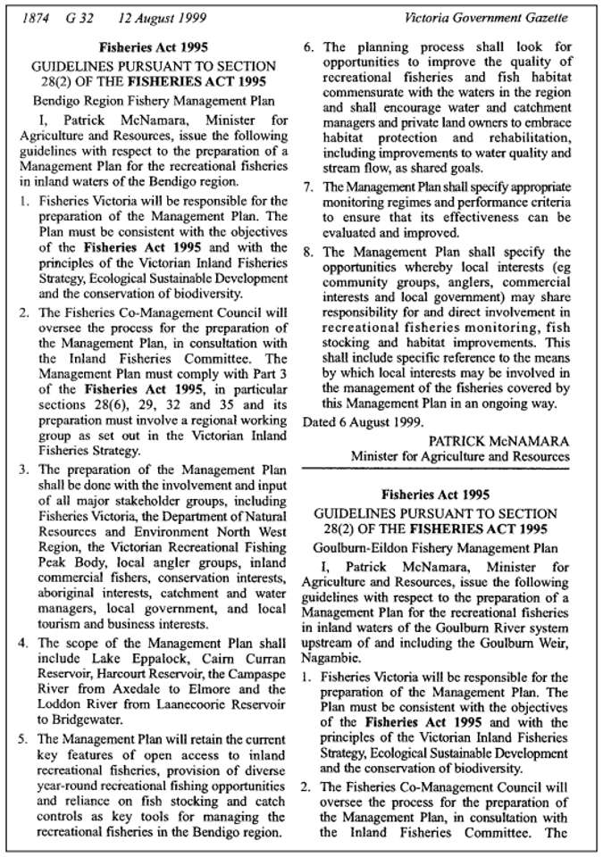
8.5 Appendix D
Fisheries Victoria Policy Statement. Trout Stocking (Public Waters)
Notes Series No. FN0006Charles Barnham (PSM)Current @ January, 1998.
4.1 Policy
4.2 Other Common Terms
4.3 Background
4.4 Stocking Requests
4.5 Stocking Intensity
4.1 Policy
NRE will produce trout for stocking inland waters of the State.
Stocking of trout will be confined to public waters except where recognised alternative arrangements exist, or where special management or research needs exist or arise.
Waters will be considered for stocking with trout where all of the following conditions are satisfied:
- sufficient acceptable or marginal habitat for their maintenance and/or growth exists;
- natural reproduction is insufficient to support a fishery;
- the fish are accessible to anglers;
- there is a reasonable expectation that enough anglers will fish the water to justify the expenses involved.
Priorities for waters considered for stocking will be determined according to habitat suitability criteria, existing or potential population levels and needs of the angling public.
Where a water is selected for stocking, trout of the largest size possible will be used.
Stocking with trout will be excluded from waters in the following categories:
- where the released fish may constitute a threat to a population of a species ofspecial concern or where a unique faunal assemblage exists;
- where natural reproduction adequately supports a fishery;
- waters east of the Snowy River catchment; and
- waters identified as unacceptable habitat.
4.2 Other Common Terms
Definitions of "Species of special concern' as adopted from the recommendations of the Australian Society for Fish Biology:
- Endangered - Taxa which have suffered a population decline over all or most of their range, whether the causes of this decline are known or not, and which may be in danger of extinction within the near future.
- Vulnerable - Taxa not presently endangered but which may be at risk by having small populations and/or by occupying restricted habitats susceptible to rapid environmental change and/or populations that are declining at a rate that would render them endangered in the near future.
- Potentially threatened - Taxa that could become vulnerable or endangered in the near future because they have a relatively large population in a restricted area, or small populations in a few areas; or have been heavily depleted and are continuing to decline, or which are dependent on specific habitat for survival.
- Indeterminate - Taxa that are likely to fall into one of the above categories but for which insufficient data are available to make an assessment.
- Restricted - Taxa that are not presently in danger but which occur in restricted areas or have suffered a long term reduction in distribution and/or abundance and are now uncommon.
"Catchable size" is taken as not less than 20 cm.
"Sizes" of fish are:
- fry (<20 mm)
- fingerlings (<100 mm)
- yearlings (100-250 mm)
- two-year-olds (250 mm plus)
"Put-and-take stocking" is where fish of "catchable size" are stocked and where a majority are expected to be caught within 2-3 months.
4.3 Background
Between 1970 and 1978, about 120 waters were stocked regularly with trout. Since then, Fisheries Victoria has been questioning and evaluating the release of trout into many of these waters. This has resulted in a more efficient use of approximately the same total weight of trout at a larger average size in about 80 waters each year.
The information gained from this work has been used to set the criteria for stocking. Acknowledging that any policy cannot cover every situation, the annual review of Regional stocking programs could identify the possible need to modify policy.
4.4 Stocking Requests
All requests for stocking should be initiated within the appropriate Region, for referral to an annual review of stocking programs with each Region. These reviews are proposed for May of each year, at which time Regions will submit their overview of client needs and opinion, as well as the stocking requests.
In conjunction with Regions, Fisheries Victoria will finalise a stocking priority schedule and implement the year's stocking program. Prior advice will be provided to Regions on details of fish releases in their areas.
To facilitate "ad hoc" requests, the procedure is:
- Refer to the criteria within this Policy.
- Check classification in "Management Plans for Victorian Waters".
- Send request and recommendation to Fisheries Victoria.
- Inform client of action taken.
- When decision is made, inform client.
4.5 Stocking Intensity
Generally, survival increases with size of fish at release. Under most conditions yearlings provide the best return to anglers. The stocking of fingerlings or smaller fish is usually unsuccessful in the presence of significant numbers of predators.
Stocking intensity is determined according to the following criteria:
- size of fish available
- size of waterbody to be stocked
- results of previous stockings
- presence or absence of predators
Policy Definitions
- "Public waters": those waters to which the angling community have unrestricted access for most of the time.
- "Recognised alternative arrangements": formal arrangements for stocking of trout approved by Fisheries Victoria and existing at the time this policy statement comes into effect.
- "Special management or research needs": needs which in the view of Fisheries Victoria are sufficient to merit variation in general policy to the overall benefit of angling in the State. The habitat is assessed in the following manner according to biological criteria (Frost and Brown 1967, Tilzey 1977, Cadwallader and Tilzey 1980):
- "acceptable habitats": lakes with a recent history of successfully supporting salmonids or having some water with temperatures not exceeding 25oC and dissolved oxygen (DO) concentrations are always above 5 ppm; streams or sections of streams without a self- supporting healthy population of salmonids and either a recent history of supporting a trout fishery or having maximum temperatures not exceeding 25oC and a minimum of 5 ppm DO concentration during any period of the year;
- "marginal habitats": lakes with maximal surface temperatures exceeding 25oC but less than 29oC or DO concentrations regularly below 5 ppm; streams with maximal temperatures exceeding 25oC or DO concentration regularly below 5 ppm; and
- "unacceptable habitats": waters having maximal temperatures exceeding 29oC or DO concentrations below 3 ppm; waters with a history of unsuccessful salmonid survival.
- "Anglers": members of the community who fish by rod and/or line in accordance with the Fisheries Act and the Fishing Regulations.
- "Species of special concern": taxa identified by the Australian Society for Fish Biology as being in any of the following categories: endangered, vulnerable, potentially threatened, indeterminate or restricted. Victorian freshwater species presently in these categories are: trout cod (endangered), Australian grayling (potentially threatened), Macquarie perch (restricted).
- "Unique faunal assemblage": a faunal association or group of associations which, in the opinion of the Fisheries Branch is, or may be, sufficiently unusual as to merit special protection.
Policy Number: 05-20-0109-1
Policy Date: 5.12.1988
FN006.DOC
This publication may be of assistance to you but the State of Victoria and its officers do not guarantee that the publication is without flaw of any kind or is wholly appropriate for your particular purposes and therefore disclaims all liability for any error, loss or other consequence which may arise from you relying on any information in this publication.
Please note that this stocking policy is currently being reviewed by MAFRI on behalf of Fisheries Victoria.
8.6 Appendix E
Fisheries Victoria Policy Statement. Native Fish Stocking (Public Waters)
Charles Barnham (PSM)
Notes Series No. FN0007
Current @ January, 1998
5.1 Policy
5.2 Status of Taxa
5.3 Background
5.4 Stocking Requests
5.5 Contact
5.6 Update
5.1 Policy
Fisheries Victoria will stock native fish in inland waters of the State for both conservation and recreational purposes.
Stocking of native fish will be confined to public waters except where special management or research needs exist or arise.
Waters will be considered for stocking with native fish for conservation purposes where al of the following conditions are satisfied:
- there is a need to maintain or enhance the conservation status of a species;
- the waters are within the known former natural range of the species, except where special management or research needs arise or exist, including maintenance of existing populations;
- there is a reasonable expectation that the fish will survive; and
- the conservation status of other native fish species or unique faunal assemblages are not put at risk.
Waters will be considered for stocking with native fish for recreational purposes where all of the following conditions are satisfied:
- there is a reasonable expectation that the habitat is suitable for survival and growth;
- recruitment is insufficient to support a fishery;
- the fish are accessible to anglers;
- there is a reasonable expectation that enough anglers will fish the water to justify the expense involved;
- the waters are within the known former natural range of the species, except where special management or research needs exist or arise, including maintenance of existing populations;
- mesh netting is not permitted; and
- the conservation status of other native fish species or unique faunal assemblages are not put at risk.
Priorities for waters considered for stocking will be based on habitat suitability criteria, existing or potential population levels of the species, capacity to monitor the stocking results, and the needs of the angling public or conservation status of the species.
NRE will encourage the participation of Regions, and other clients in native fish stocking.
5.2 Status of Taxa
- Endangered - Taxa which have suffered a population decline over all or most of their range, whether the causes of this decline are known or not, and which may be in danger of extinction within the near future.
- Vulnerable - Taxa not presently endangered but which may be at risk by having small populations and/or by occupying restricted habitats susceptible to rapid environmental change and/or populations that are declining at a rate that would render them endangered in the near future.
- Potentially threatened - Taxa that could become vulnerable or endangered in the near future because they have a relatively large population in a restricted area, or small populations in a few areas; or have been heavily depleted and are continuing to decline, or which are dependent on specific habitat for survival.
- Indeterminate - Taxa that are likely to fall into one of the above categories but for which insufficient data are available to make an assessment.
- Restricted - Taxa that are not presently in danger but which occur in restricted areas or have suffered a long-term reduction in distribution and/or abundance and are now uncommon.
5.3 Background
The Fisheries Branch has developed facilities a its Snobs Creek Station near Eildon for production of native fishes. These facilities provide supplies of Macquarie perch, Murray cod and trout cod in addition to golden perch and Murray cod purchased from commercial fish farms to support NRE's programs for recreational use of native fish and for their longer-term conservation.
This policy provides a framework within which decisions can be made on the deployment of native fishes produced by NRE.
5.4 Stocking Requests
All requests for stocking should be initiated within the appropriate Region, for referral to an annual review of stocking programs with each Region.
These reviews are conducted during February-April each year, at which time Regions will submit their overview of client needs and opinion, as well as the stocking requests. In conjunction with Regions, Fisheries Victoria will finalise a stocking priority schedule and implement the year's stocking program.
Prior advice will be provided to Regions on details of fish releases in their areas.
To facilitate "ad hoc" requests, the procedure is:
- Refer to the criteria within this Policy.
- Check classification in "Recreational Fisheries Management Actions for Victorian Fresh Waters" (Barnham 1987).
- Send request and recommendation to Manager - Recreational Fisheries, Fisheries Victoria (address below).
- Inform client of action taken.
- When decision is made, inform client.
5.5 Contact
Manager - Recreational Fisheries,
Fisheries Victoria
Level 6, 232 Victoria Parade
East Melbourne
VIC 3002
Policy Number: 05-20-0108-1
Policy Date: 5.12.1988
5.6 Update
Snobs Creek Hatchery: Development of native fish research and production facilities was completed in 1989. The initial concentration of the Hatchery is on the native fish species for which there is primarily a conservation Action: Murray cod, trout cod and Macquarie perch.
Details of NRE's stockings of these species into suitable streams and lakes are available in NRENOTES - Fisheries NOTES series - Native Fish Releases - individual information sheets for each year with periodic consolidations into 5 year reports.
Policy Definitions
- "Public waters": those waters to which the angling community have unrestricted access for most of the time.
- "Native fish": species of fish as defined under the Fisheries Act occurring in Victoria as part of the State's indigenous fresh water aquatic fauna.
- "Conservation purposes": stocking to ensure the long-term survival of native fish.
- "Recreational purposes": stocking to meet a demand for active and passive use of fish resources by anglers and the general public.
- "Special management or research needs": needs which in the view of Fisheries Victoria are sufficient to merit variation in general policy to the overall benefit of conservation and/or angling in the State.
- "Anglers": members of the community who fish by rod and/or line in accordance with the Fisheries Act and Regulations made thereunder.
- "Conservation status": status of taxa as identified by the Australian Society for Fish Biology as being in any of the following categories: endangered, vulnerable, potentially threatened, indeterminate or restricted.
- Victorian freshwater species presently in these categories are: trout cod (endangered), Australian grayling (potentially threatened), Macquarie perch (restricted).
- "Unique faunal assemblage": a faunal association or group of associations which, in the opinion of the Fisheries Branch, merits special protection.
This publication may be of assistance to you but the State of Victoria and its officers do not guarantee that the publication is without flaw of any kind or is wholly appropriate for your particular purposes and therefore disclaims all liability for any error, loss or other consequence which may arise from you relying on any information in this publication.
Please note that this stocking policy is currently being reviewed by MAFRI on behalf of Fisheries Victoria.
Footnote
1 migratory species
2 listed as threatened fauna in Victoria (NRE 1999).
3 denotes species provided legal protection under the FFG.
* Populations of Spotted galaxias have been located in the upper Coliban River and some smaller tributaries of Lake Eppalock. This species is normally found in coastal drainages and this feral population may be the result of anglers using them as live bait.