Guidelines and Ongoing Monitoring of Aquaculture Fisheries Reserves
Management Report Series No. 35
April 2006
ISSN: 1448-1693
ISBN: 1 74146 644 X
Preferred way to cite this publication:
Fisheries Victoria, DPI (2006). Guidelines for Environmental Baseline Surveys and Ongoing Monitoring of Aquaculture Fisheries Reserves in Port Phillip and Western Port. Fisheries Victoria,DPI Management Report Series No. 35.
1 Introduction
The Guidelines for Environmental Baseline Surveys and Ongoing Monitoring of Aquaculture Fisheries Reserves in Port Phillip and Western Port (the Guidelines) prescribe the methods by which aquaculture proponents, and or their nominated service providers, are to conduct baseline surveys and ongoing monitoring of Crown lease sites within aquaculture fisheries reserves (AFRs) in Port Phillip and Western Port.
All baseline surveys and ongoing monitoring are to be conducted using the prescribed methods and in accordance with the prescribed standards unless otherwise authorised.
The Guidelines prescribe two stages of environmental assessment:
- a baseline survey is a one–off survey of the sediment and seabed of greenfield Crown lease sites to be undertaken by Crown lease holders within one year from the commencement date of the Crown lease and prior to the commencement of aquaculture activity; and
- ongoing monitoring is the monitoring of Crown lease sites to be undertaken by aquaculture licence holders annually for aquaculture using non–artificial feeds or as specified by the Secretary, Department of Primary Industries (DPI), or twice a year for aquaculture using artificial feeds or as specified by the Secretary, DPI.
1.1 Environmental management framework
The environmental management framework detailed in the AFR management plans is based on the following three key components:
- a characterisation survey;
- a baseline survey; and
- ongoing monitoring.
1.1.1 Characterisation survey
A characterisation survey is a one–off assessment of the habitat, physico–chemical and biological attributes of an AFR. Fisheries Victoria with this department have conducted characterisation surveys for all AFRs.
1.1.2 Baseline survey
A baseline survey is a one–off assessment of the sediment and seabed of greenfield Crown lease sites. A baseline survey shall be carried out by the Crown lease holder and or their nominated service provider.
1.1.3 Ongoing monitoring
Ongoing monitoring refers to the ongoing assessment of the Crown lease site with particular emphasis on appropriate performance indicators, and associated management triggers identified in the management plans. Ongoing monitoring of the Crown lease site shall be carried out by the aquaculture licence holder and or their nominated service provider.
1.2 Environmental monitoring requirements
The environmental variables to be monitored for baseline and ongoing monitoring in the AFRs are summarised in Table 1.
1.2.1 Crown lease sites sharing a common border
Where Crown lease sites share a common border, baseline surveys or ongoing monitoring may be conducted as a single Crown lease site.
1.3 Timing of baseline surveys and ongoing monitoring
The aquaculture proponent, and or their nominated service provider, must notify Fisheries Victoria, DPI of the sampling date chosen at least 48 hours prior to conducting the survey to facilitate compliance activities.
All sampling surveys and video surveys shall be completed within a 48 hour period at any one Crown lease site, unless otherwise authorised by the Secretary, DPI.
The Crown lease holder shall conduct a baseline survey within one year from the commencement date of the Crown lease and prior to the commencement of aquaculture activity.
Existing aquaculture operators are not required to undertake baseline surveys for Crown leases developed prior to the declaration of the relevant management plan.
For aquaculture using non–artificial feeds, ongoing monitoring shall be undertaken annually (or as specified by the Secretary, DPI) during the same month as the baseline survey to avoid seasonal variation between samples. For existing aquaculture operators, where a baseline survey is not required, ongoing monitoring shall be undertaken during the same month each year.
For aquaculture using artificial feeds, ongoing monitoring shall be undertaken twice a year or as specified by the Secretary, DPI. Where a baseline survey has been conducted, the first ongoing monitoring event shall occur six months later; all subsequent monitoring events shall occur in the same month as the baseline survey and the first ongoing monitoring event. Where a baseline survey is not required, ongoing monitoring shall be undertaken during the same months as the first two monitoring events.
1.4 Service providers
Baseline surveys and ongoing monitoring may be undertaken by any appropriately qualified service provider that adheres to the prescribed methods as outlined in these Guidelines.
Service providers shall be experienced in the area of marine environmental monitoring with demonstrated skills in marine ecological sampling, marine species identification and underwater video analysis.
Such service providers may include appropriate government agencies and private sector business enterprises, as nominated by the Crown lease holder for baseline surveys and the aquaculture licence holder for ongoing monitoring.
1.5 Auditing procedures
Baseline surveys and ongoing monitoring may be audited by Fisheries Victoria, DPI for compliance with the Guidelines. Auditing may include three key components:
- field surveys may be audited to assess methods of data collection in the field;
- data and analysis may be audited to assess the validity of the data, the analytical integrity and the accuracy of the report; and
- reports will be audited to ensure they include all the required information. All reports will be audited.
Checklists will be used to guide the audits (Appendices 14–19).
Where non–compliance with the requirements of the Guidelines is found, the Crown lease holder or the aquaculture licence holder (for baseline surveys or ongoing monitoring respectively) shall be required to correct the non–compliance and advise Fisheries Victoria, DPI of any action taken to correct and prevent the recurrence of noncompliance.
Table 1: Environmental monitoring requirements for baseline surveys and ongoing monitoring (Source: modified from Gavine and McKinnon, 2002).
| Method | Variable |
Baseline surveya | Ongoing monitoringb | |
|---|---|---|---|---|
|
Aquaculture using non–artificial feeds |
Aquaculture using artificial feeds | |||
| Sampling survey | Carbon nitrogen ratio | X | X | * |
| Redox | 
| * | * | |
| Total organic carbon |
| * | * | |
| Sediment particle size |
| * | * | |
| Visual |
| * | * | |
| Infauna |
| * | * | |
| Video survey | Vegetation |
|
|
|
| Epifauna |
|
|
| |
a – to be completed by the Crown lease holder or nominated service provider
b – to be completed by the aquaculture licence holder or nominated service provider –
required
X – not required
* – required upon activation of management trigger
In addition, the environmental monitoring framework will be the subject of an independent audit to assess the accuracy and adequacy of information generated by the environmental monitoring framework.
1.6 Review of guidelines
The Guidelines are a key action of the AFR management plans which describe the management of the AFRs with an emphasis on ecologically sustainable development and as such the Guidelines will be reviewed at the same time as the AFR management plans. Prior to that time, the Guidelines may be subject to review should there be a need for the Secretary, DPI, to amend the Guidelines.
The Guidelines may be amended from time to time based on changes in:
- aquaculture technology or techniques;
- understanding of the risks; and
- technological advances in environmental monitoring.
Updated Guidelines will be numbered and dated, with the most recent version being the correct Guidelines. A table inside the Guidelines shall list the date and number of all previous versions of the Guidelines (Table 2).
1.7 Public reporting
Public reporting on environmental monitoring undertaken within the AFRs is a primary component of public accountability for the management of AFRs. Characterisation studies, baseline surveys and ongoing monitoring information shall be available to the public.
1.8 Contact us
For consultation with Fisheries Victoria, DPI contact the Customer Service Centre on telephone 136 186 and they will transfer you to the Fisheries Victoria, DPI Officer responsible for assisting Crown lease and aquaculture licence holders undertaking baseline surveys and or ongoing monitoring.
Table 2: Guidelines for environmental baseline surveys and ongoing monitoring of aquaculture fisheries reserves amendment record.
| Version | Date | Initials |
|---|---|---|
2 Baseline surveys
A one–off baseline survey shall be carried out by the Crown lease holder, and or their nominated service provider, for all individual, greenfield Crown lease sites within one year from the commencement date of the Crown lease and prior to the commencement of aquaculture activity.
Existing aquaculture operators are not required to undertake baseline surveys for Crown leases developed prior to the declaration of the relevant management plan.
Table 3: The number of survey transects, compliance points and reference points required to be surveyed according to the size of Crown lease.
|
Size of Crown lease site (ha) |
Required number of 300 m survey transects |
Required number of compliance points |
Required number of reference points |
|---|---|---|---|
| 0–10 | 1 | 6 | 6 |
| 11–20 | 2 | 8 | 8 |
| 21–30 | 3 | 10 | 10 |
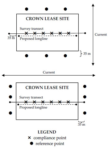
Figure 1: Schematic of Crown lease site indicating approximate placement of the survey transect, reference points and compliance points in relation to current (diagram not to scale).
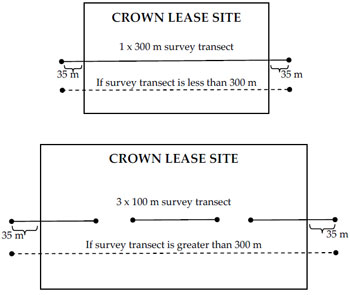
Figure 2: Schematic of Crown lease site indicating approximate placement of the survey transect in relation to the size of the Crown lease site (diagram not to scale).
2.1 Survey design
The Crown lease holder, in consultation with Fisheries Victoria, DPI, will determine the exact location and number of survey transects, reference points and compliance points prior to conducting the survey. The survey transects, reference points and compliance points may be at the same location and or at a different location to previous surveys. The number of survey transects, compliance points and reference points may vary according to the size of the Crown lease site (Table 3).
2.1.1 Survey transect
Longlines shall not be present during the baseline survey; however, the survey transect shall be positioned as close as possible to the site of the proposed aquaculture equipment. The survey transect (Figure 1) shall be set along a central line within the Crown lease and shall extend at least 35 m beyond the Crown lease at both ends. Where the total length of the transect exceeds 300 m due to the size of the Crown lease, the transect should be divided into three 100 m transects: two 100 m transects, each extending from at least 35 m beyond opposing Crown lease boundaries towards the centre of the Crown lease; and one 100 m transect centred on the midpoint of the Crown lease (Figure 2).
2.1.2 Compliance points
Longlines shall not be present during the baseline survey; however, compliance points shall be positioned as close as possible to the site of the proposed aquaculture equipment.
All compliance points shall be located within the Crown lease, at least 20 m apart from one another and shall be positioned on the survey transect.
2.1.3 Reference points
All reference points shall be located:
- 35 m beyond the Crown lease;
- parallel to the Crown lease boundary;
- at least 20 m apart from one another;
- half the reference points shall be located upstream of the prevailing current; and
- half the reference points shall be located down–stream of the prevailing current.
If current direction is not known or variable, additional reference points may be required.
2.2 Sampling survey specifications
Sampling surveys shall be carried out at compliance points and at reference points. The Crown lease holder, in consultation with Fisheries Victoria, DPI, will determine the reference points to be sampled prior to conducting the baseline survey.
2.2.1 Benthic infauna collection and analysis
2.2.1.1 Collection of benthic infauna
Each sample shall be collected as follows:
- one sediment grab shall be collected at the agreed compliance points and at the agreed reference points with a Van Veen grab (or equivalent apparatus) able to cover a surface area of 0.1 m2 and has a capacity of 20 litres; and
- each sample shall be sieved (Section 2.2.1.2) and stored within 3 hours of collection in 10% buffered formalin.
2.2.1.2 Sieving of benthic infauna
Each sample shall be sieved using the following sequence:
- carefully and thoroughly washed into a 1 mm stainless steel mesh sieve using salt or fresh water;
- rinsed over the sieve to remove fine sediments;
- picked over to remove coarse inorganic material and debris such as detritus and empty shells (check whole gastropod shells are empty by gently breaking them); and
- transferred into strong sealable plastic containers with their label and submerged in 10% buffered formalin such that the container shall be no more than half full of sample and filled to the top with formalin.
2.2.1.3 Analysis of benthic infauna
After being stored in 10% buffered formalin for at least three days each benthic infauna sample shall be processed using the following sequence:
- formalin removed by gently rinsing each sample through a 1 mm sieve with water;
- all organisms in each sample sorted; and
- each organism identified to at least family level, or to species level for known introduced species, counted and recorded on a benthic fauna identification data record sheet (Appendix 5).
2.2.1.4 Storage of benthic infauna
After identification and enumeration, the benthic infauna samples shall be transferred to 70% ethanol for long–term storage as follows:
- samples shall be stored in sealable polythene or polypropylene containers, which shall be clearly and permanently labelled (Appendix 3); and
- samples shall be securely stored out of direct sunlight, and maintained for at least five years after the date of collection to provide for independent auditing.
All stored samples shall be made available to the Secretary, DPI, upon request.
2.2.2 Physico–chemical sample collection and analysis
Each sample shall be collected and analysed as follows:
one sediment core shall be collected at the agreed compliance points and at the agreed reference points with a Craib Corer (or equivalent apparatus);
- sediment cores shall be collected in transparent perspex tubes called a core barrel (approximately 50 mm diameter and 220 mm length) and sealed immediately upon arrival on deck;
- cores shall be retained upright, sealed and undisturbed, and shall be stored in the dark at 4°C until redox and total organic carbon (TOC) are measured; and
- samples shall be discarded if the sediments have been significantly disturbed or where water has drained from the sediments.
2.2.2.1 Sediment core description
Sediment cores shall be described with regards to length (cm), colour (record a maximum of two colour using a Munsell soil colour chart), presence of hydrogen sulphide odour, presence of plants or animals and presence of gas bubbles (Appendix 6).
2.2.2.2 Oxidation reduction potential Redox measurements shall be made on each undisturbed sediment core within 2 hours of retrieval using a suitable electrode as follows:
- measurements shall be taken at the surface (sediment–water interface) and at 10 and 40 mm depths within the sediment sample (Appendix 7) ;
- in low permeable sediments the electrode should be allowed to equilibrate at each depth until it's value is changing by less than 1 mV/sec;
- in permeable sediments the lowest reading in each sample should be recorded because movement of the probe draws surface waters into the sediments;
- the redox probe shall be washed with distilled water and tested in a standard buffer solution between each sample; and
- redox measurements shall be reported in millivolts (mV).
All redox measurements are to be calibrated against a standard reference solution.
2.2.2.3 Total organic carbon After redox measurements have been made:
- the top 30 mm of the sediment core shall be collected by extruding the core from the barrel by pushing a tight fitting plunger up through the bottom of the barrel;
- the sample shall be cut or scraped off and placed in a bowl then homogenised by mixing with a spatula;
- a 10 g subsample shall be removed from the homogenised sample, placed with a label in a labelled jar and stored in the dark at –18°C until sent to a National Association of Testing Authorities (NATA) accredited laboratory for TOC analysis (Appendix 8); and
- the remaining sample shall be put aside for sediment particle size analysis.
2.2.2.4 Sediment particle size analysis
After the TOC sample has been taken and the top 30 mm of the sediment core has been collected, sediment particle size analysis shall be conducted as follows:
- the next 70 mm (30–100 mm) of the sediment core shall be collected by extruding the core from the barrel by pushing a tight fitting plunger up through the bottom of the barrel;
- the sample shall be cut or scraped off and placed in a bowl, then homogenised by mixing with a spatula;
- a proportional amount of sediment core (to that removed from the 0–30 mm for TOC analysis) shall be removed and discarded from the 30–100 mm sample, that is for each 10 g subsample removed from the 0–30 mm sample for TOC analysis, 23 g of sediment core shall be removed and discarded from the 30–100 mm sample;
- the 0–30 mm sample remaining from TOC analysis shall be placed in the bowl with the 30–100 mm sample, then homogenised by mixing with a spatula; and
- a labelled sample jar shall be packed full with the homogenised mixture, the sample label shall be placed on top of the sample and the lid screwed on, the sample is then ready for sediment particle size analysis.
Sediment particle size analysis can be done to a degree of accuracy of <3% in a suitably equipped laboratory using the following procedure:
- a sample of wet sediment shall be wet sieved through a stack of seven sieves using gentle hosing either by hand or a sieve shaker;
- the sieve stack shall be made up of 4 mm, 2 mm, 1 mm, 0.5 mm, 0.25 mm, 0.125 mm and 0.063 mm stainless steel mesh sieves;
- the drained contents of each sieve from coarsest to finest particle size shall be placed into a measuring cylinder containing 20 ml of water;
- the cumulative volume from each sieve shall be recorded and the volume from each sieve shall be computed;
- the volume of the <0.063 mm fraction shall be calculated by subtracting the total volume collected in all the sieves from the initial volume in the sample jar; and
- the particle size distribution shall then be tabulated and graphed as percent by volume (Appendix 9).
All sediment particle size shall be described using the Udden–Wentworth scale.
2.3 Video survey specifications
Video surveys shall be conducted along the survey transects, at compliance points and reference points.
2.3.1 Video surveys
Video surveys shall be conducted as follows:
- video recording may be conducted by diver, underwater tow or remotely operated vehicle (ROV);
- the time and date shall be visible on the video footage at all times;
- video footage of survey transects shall be continuous, unedited and the camera speed along the transect shall not exceed 1 m/s;
- stationary video footage of reference points and compliance points shall be unedited and at least 15 seconds in duration after which time a further 60 seconds of footage shall be taken of the immediate area surrounding the compliance point or reference point;
- at each compliance point and reference point, the sediment shall be gently disturbed while filming to reveal the sediment colour beneath the surface;
- the camera shall be held no more than 1 m above the substrate and include a view of at least 0.5 m around each point;
- the substrate shall be in focus at all times; and
- all images shall be clear and well-lit.
2.3.2 Video camera
The video camera shall be capable of recording:
- in colour;
- at 1 lux or less plus have an artificial light source (a minimum of 2 x 50 W lights);
- with the date and time visible on the footage at all times;
- in PAL format; and
- on Hi–8 video tape, mini–DV video tape or the equivalent.
2.3.3 Video footage description
Video records are required to provide both a general overview and localised qualitative data (Appendices 10–12). Video footage shall be described with regards to:
- sediment colour and texture;
- seaweed cover;
- visibility;
- variety and density of epifauna on the sea bed;
- presence of Beggiatoa spp. (white bacterial mats);
- presence of opportunistic polychaetes (e.g. Capitellids) on the sediment surface;
- release of bubbles from the sediment; and
- presence of any other extraneous materials related to aquaculture infrastructure or activities.
2.3.4 Video analysis
The interpretation of video information shall be verified by more than one analyst (Appendices 10 and 11).
2.4 Data recording and quality assurance
- Survey records shall include: date;
- start time;
- finish time;
- Reserve name;
- Crown lease number;
- vessel name;
- weather conditions;
- staff names;
- data recorder;
- Team Leader;
- sample ID;
- type of sample;
- depth (m);
- time of collection; and
- location (using GPS and recorded in either GDA94 degrees decimal minutes) (Appendix 4).
2.4.1 Data collection and analysis
All data shall be managed as follows:
- a waterproof label detailing the Crown lease site, date, sample ID, assessor's name and collector's name shall be placed with each sample (Appendix 3). This label shall remain with the sample through all sample processing stages;
- if a data field is not required it shall be marked with a 'strikethrough';
- all field data shall be recorded on waterproof data sheets using a 2B pencil;
- the interpretation of video information shall be verified by more than one analyst;
- TOC analysis and carbon nitrogen ratio analysis shall be undertaken by an agency holding NATA accreditation for those tests; and
- all data sheets shall be verified by the Team Leader.
2.4.2 Database
All raw data shall be managed as follows:
- all raw data shall be entered into a database template provided by Fisheries Victoria, DPI;
- all electronic data shall be verified by more than one analyst. The analysts shall sign the quality assurance data sheet (Appendix 13) to confirm all data has been verified; and
- the Team Leader shall sign the quality assurance data sheet (Appendix 13) to verify all data has been collected and entered into the database according to the prescribed methods and standards.
2.5 Reporting
The Crown lease holder must deliver a copy of an Interim Baseline Survey Report to Fisheries Victoria, DPI for approval within one month of completion of the survey fieldwork and the Final Baseline Survey Report within four months of the completion of survey fieldwork.
The Interim Baseline Survey Report shall contain:
- a hard copy of the sample location data sheet; and
- a copy of the video footage on Hi–8 video tape, mini–DV video tape or the equivalent in PAL format.
The Final Baseline Survey Report shall contain:
- Crown lease number;
- Reserve name;
- aquaculture licence number;
- applicant's name;
- name of person / organisation conducting environmental assessment;
- an introduction – preamble to the report indicating any previous work done relevant to this report and previous work done at the Crown lease site;
- the methods used for the assessment of each parameter presented in the same order as in the Guidelines;
- the results presented in the same order as in the Guidelines and data summarised in tables and graphs;
- an interpretation of the data providing an integrated understanding of the results plus any unusual results highlighted;
- a copy of the raw data attached as appendices and provided electronically in spreadsheets (templates shall be provided);
- a photograph (or a still from stationary video footage) of each reference point and compliance point; and
- a map of the Crown lease site with all compliance points, reference points and survey transects, including their coordinates.
All original data, video footage and samples shall be retained by Crown lease holders for auditing purposes for a period of five years or as specified by the Secretary, DPI.
The data shall be maintained by Fisheries Victoria, DPI, within a data management system. Fisheries Victoria, DPI will utilise this system for data analysis, reporting and management needs, consistent with the objectives of the AFR management plans.
Reports and data to be sent to:
Manager Aquaculture
Department of Primary Industries
GPO Box 4440
Melbourne VICTORIA 3001
3 Ongoing monitoring
Ongoing monitoring of the Crown lease site shall be carried out by the aquaculture licence holder and or their nominated service provider.
Monitoring shall be carried out annually for aquaculture using non–artificial feeds or as specified by the Secretary, DPI, or twice a year for aquaculture using artificial feeds or as specified by the Secretary, DPI, with emphasis on appropriate performance indicators, and associated management triggers identified in the management plans.
Table 4: The number of survey transects, compliance points and reference points required to be surveyed according to the size of Crown lease.
|
Size of Crown lease site (ha) |
Required number of 300 m survey transects |
Required number of compliance points |
Required number of reference points |
|---|---|---|---|
| 0–10 | 1 | 6 | 6 |
| 11–20 | 2 | 8 | 8 |
| 21–30 | 3 | 10 | 10 |
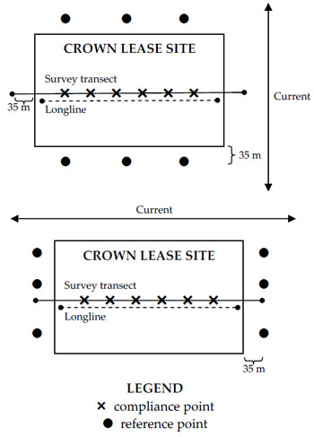
Figure 3: Schematic of Crown lease site indicating approximate placement of the survey transect, reference points and compliance points in relation to current (diagram not to scale).
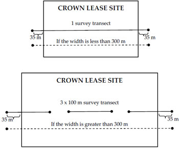
Figure 4: Schematic of Crown lease site indicating approximate placement of the survey transect in relation to the size of the Crown lease site (diagram not to scale).
3.1 Survey design
The aquaculture licence holder, in consultation with Fisheries Victoria, DPI, will determine the exact location of the survey transects, compliance points and reference points prior to conducting the survey. The number of survey transects, compliance points and reference points may vary according to the size of the Crown lease site (Table 4).
3.1.1 Survey transect
The survey transect shall be set along a longline within the Crown lease and shall extend at least 35 m beyond the Crown lease at both ends (Figure 3). Where the total length of the transect exceeds 300 m due to the size of the Crown lease, the transect may be divided into three sections: two 100 m transects, each extending from at least 35 m beyond opposing Crown lease boundaries towards the centre of the Crown lease; and one 100 m transect centred on the midpoint of the Crown lease (Figure 4).
3.1.2 Compliance points
Compliance points shall be positioned as close as possible to the site of the aquaculture equipment. All compliance points shall be located within the Crown lease, at least 20 m apart from one another and shall be positioned on the survey transect.
3.1.3 Reference points
All reference points shall be located:
- 35 m beyond the Crown lease;
- parallel to the Crown lease boundary;
- at least 20 m apart from one another;
- half the reference points shall be located upstream of the prevailing current; and
- half the reference points shall be located down–stream of the prevailing current.
If current direction is not known or variable, additional reference points may be required.
3.2 Video survey specifications
Video surveys shall be conducted out along the survey transect, at compliance points and at reference points.
3.2.1 Video surveys
Video surveys shall be conducted as follows:
- video recording may be conducted by diver, underwater tow or remotely operated vehicle (ROV);
- the time and date shall be visible on the video footage at all times;
- video footage of survey transects shall be continuous, unedited and the camera speed along the transect shall not exceed 1 m/s;
- stationary video footage of reference points and compliance points shall be unedited and at least 15 seconds in duration after which time a further 60 seconds of footage shall be taken of the immediate area surrounding the compliance point or reference point;
- at each compliance point and reference point, the sediment shall be gently disturbed while filming to reveal the sediment colour beneath the surface;
- the camera shall be held no more than 1 m above the substrate and include a view of at least 0.5 m around each point;
- the substrate shall be in focus at all times; and
- all images shall be clear and well–lit.
3.2.2 Video camera
The video camera shall be capable of recording:
- in colour;
- at 1 lux or less plus have an artificial light source (a minimum of 2 x 50 W lights);
- with the date and time visible on the footage at all times;
- in PAL format; and
- on Hi–8 video tape, mini–DV video tape or the equivalent.
3.2.3 Video footage description
Video records are required to provide both a general overview and localised qualitative data (Appendices 10–12). Video footage shall be described with regards to:
- sediment colour and texture;
- seaweed cover;
- visibility;
- variety and density of epifauna on the sea bed; – presence of Beggiatoa spp. (white bacterial mat);
- presence of opportunistic polychaetes (e.g. Capitellids) on the sediment surface;
- release of bubbles from the sediment; and
- presence of any other extraneous materials related to aquaculture infrastructure or activities.
3.2.4 Video analysis
The interpretation of video information shall be verified by more than one analyst (Appendices 10 and 11).
3.3 Data recording and quality assurance
Survey records shall include:
- date;
- start time;
- finish time;
- Reserve name;
- Crown lease number;
- vessel name;
- weather conditions;
- staff names;
- data recorder;
- Team Leader;
- sample ID;
- type of sample;
- depth (m);
- time of collection; and
- location (using GPS and recorded in either GDA94 degrees decimal minutes) (Appendix 4).
3.3.1 Data collection and analysis
All data shall be managed as follows:
- if a data field is not required it shall be marked with a 'strikethrough';
- all field data shall be recorded on waterproof data sheets using a 2B pencil;
- the interpretation of video information shall be verified by more than one analyst; and
- all data sheets shall be verified by the Team Leader.
3.3.2 Database
All data shall be managed as follows:
- all raw data shall be entered into a database template provided by Fisheries Victoria, DPI;
- all electronic data shall be verified by more than one analyst to ensure accurate data entry. The analysts shall sign the quality assurance data sheet (Appendix 13) to confirm all data has been verified; and
- the Team Leader shall sign the quality assurance data sheet (Appendix 13) to verify all data has been collected and entered into the database according to the prescribed methods and standards.
3.4 Activation of a management trigger
Management triggers include, but are not limited to:
- the presence of Beggiatoa spp. mats;
- organic accumulation; or
- the presence of debris.
Where monitoring identifies a management trigger, further monitoring will be conducted according to the procedures described in Section 2: Baseline survey.
In addition, aquaculture using artificial feeds shall collect and analyse carbon nitrogen ratios at compliance points and reference points. Sample collection for carbon nitrogen ratios shall follow the same procedure as for TOC analysis. For carbon nitrogen ratio analyses a second 10 g subsample shall be sent to a National Association of Testing Authorities (NATA) accredited laboratory for carbon nitrogen ratio analysis (Appendix 8).
3.5 Reporting
A written report for the ongoing monitoring undertaken by the aquaculture licence holder is to be provided to Fisheries Victoria, DPI no later than two months after the completion of the ongoing monitoring event.
The Ongoing Monitoring Report shall contain:
- Crown lease number;
- Reserve name;
- aquaculture licence number;
- applicant's name; – name of person / organisation conducting environmental assessment;
- an introduction – preamble to the report indicating any previous work done relevant to this report and previous work done at the Crown lease site;
- methods and results;
- data summarised in tables and graphs;
- an interpretation of the data providing an integrated understanding of the results plus any unusual results highlighted;
- recommendations in regard to compliance with management triggers;
- a copy of the raw data attached as appendices and provided electronically in spreadsheets (templates shall be provided);
- a photograph (or a still from stationary video footage) of each reference point and compliance point;
- a map of the Crown lease site with all compliance points, reference points and survey transects, including their coordinates; and
- a copy of the video footage on Hi–8 video tape, mini–DV video tape or the equivalent in PAL format.
All original data, video footage and samples shall be retained by Crown lease holders for auditing purposes for a period of five years or as specified by the Secretary, DPI.
The data shall be maintained by Fisheries Victoria, DPI, within a data management system. Fisheries Victoria, DPI will utilise this system for data analysis, reporting and management needs, consistent with the objectives of the AFR management plans.
Reports and data to be sent to:
Manager Aquaculture
Department of Primary Industries
GPO Box 4440
Melbourne VICTORIA 3001
4 References
Barry, J. M., and Bailey, M. (2001) Bathymetric survey of the proposed aquaculture zone, Pinnace Channel, Port Phillip. Marine and Freshwater Research Institute Report No. 35.
Coleman, N., Longmore, A. and Cohen, B. (2001) Baseline data for the Pinnace Channel aquaculture site. Marine and Freshwater Research Institute Report No. 34.
DPIWE (2004) A review of the Tasmanian finfish farming benthic monitoring program. Marine Environment Section, Marine Farming Branch, Marine Resources Group, DPIWE, Tasmania.
DPI (2005) Eastern port Phillip Bay Aquaculture Fisheries Reserves Management Plan. Fisheries Victoria, DPI Management Report Series No. 33.
DPI (2005) Flinders Aquaculture Fisheries Reserve Management Plan. Fisheries Victoria, DPI Management Report Series No. 32.
DPI (2005) Geelong Arm Aquaculture Fisheries Reserves Management Plan. Fisheries Victoria, DPI Management Report Series No. 34.
DPI (2005) Pinnace Channel Aquaculture Fisheries Reserve Management Plan. Fisheries Victoria, DPI Management Report Series No. 31.
ECC (2000) Marine Coastal and Estuarine Investigation – Final Report.
Gavine, F. and McKinnon, L. (2002) Environmental monitoring of marine aquaculture in Victorian coastal waters: A review of appropriate methods. Marine and Freshwater Research Institute Report No. 46.
GESAMP (IMO / FAO / Unesco–IOC / WMO / WHO/ IAEA / UN / UNEP Joint Group of Experts on the Scientific Aspects of Marine Environmental Protection) (1996) Monitoring the ecological effects of coastal aquaculture wastes. GESAMP Reports and Studies No. 57.
McKinnon, L.J., Leporati, S.C., Parry, G.D., Blake, S. and Hatton, D. (2004a) Environmental characterisation of the Aquaculture Fisheries Reserves in the Geelong Arm, Port Phillip Bay, Victoria. Fisheries Victoria, DPI Research Report Series No. 8.
McKinnon, L.J., Leporati, S.C., Parry, G.D., Blake, S. and Hatton, D. (2004b) Environmental characterisation of the aquaculture fisheries reserves in Eastern Port Phillip Bay, Victoria. Fisheries Victoria, DPI Research Report Series No. 10.
McKinnon, L.J., Leporati, S.C., Parry, G.D. and Blake, S. (2004c) Environmental characterisation of the Flinders Aquaculture Fisheries Reserve in Western Port, Victoria. Fisheries Victoria, DPI Research Report Series No. 14.
McKinnon, L.J., Leporati, S.C., Parry, G.D., Blake, S. and Hatton, D. (2005) Environmental characterisation of the Aquaculture Fisheries Reserve in Portland Bay, Victoria. Fisheries Victoria, DPI Research Report Series No. 22.
McKinnon, L.J., Parry, G.D., Leporati, S., Heislers, G.F., Werner, G.F., Gason, A.S.H., Fabris, G., and O'Mahoney, N. (2003) The environmental effects of blue mussels (Mytilus edulis) aquaculture in Port Phillip Bay. Fisheries Victoria, DPI Research Report Series No. 1.
5 Abbreviations
| AFR | Aquaculture Fisheries Reserve |
| C | Carbon |
| cm | Centimetre |
| °C | Degrees Celsius |
| DPI | Department of Primary Industries (Victoria) |
| DPIWE | Department of Primary Industries, Water and Environment (Tasmania) |
| ECC | Environment Conservation Council |
| g | Grams |
| GDA | Geocentric Datum of Australia |
| GPS | Global positioning system |
| ha | Hectare |
| ID | Identification |
| m | Metre |
| ml | Millilitre |
| mm | Millimetre |
| mV | Millivolt |
| N | Nitrogen |
| NATA | National Association of Testing Authorities |
| Redox | Oxidation reduction potential |
| PIRVic | Primary Industries Research Victoria |
| QA | Quality assurance |
| ROV | Remotely operated vehicle |
| sec | Second |
| TOC | Total organic carbon |
| W | Watts |
| µm | Micrometre |
6 Glossary
| Artificial feeding | A method of culture that requires the use of supplementary feed including, but not limited to pelleted formulated feeds, whole/trash fish and byproducts used for aquaculture. |
| Baseline survey | An initial assessment of physico–chemical, environmental and biological attributes of the specific Crown lease site. |
| Crown lease site | The area of land specified on a Crown lease issued under the Land Act 1958 and or the area specified on an aquaculture licence issued under section 43 of the Fisheries Act 1995 within which aquaculture activity is authorised. |
| Ecologically sustainable development | A term used to describe development that takes account of environmental sustainability, economic viability and social equity. |
| Epifauna | Animals that live on the sea floor, or attached to other animals or objects underwater. |
| Existing aquaculture operators | Those aquaculture licence holders who have been authorised to conduct aquaculture over a specific site prior to 1 January 2006. |
| Fallow | Method of allowing sea floor to lie for a season or more, in order to increase its productivity or to allow it to recover from the stresses of cultivation. |
| Greenfield | An area not previously developed. |
| Non–artificial feeding | A method of culture that does not require the use of artificial feed. |
| Stock | The aquaculture species specified in an aquaculture licence for culture. |
| Stocked site | A site that contains a cage that has been stocked and not moved from its current location for a period of at least 6 months. |
| Team Leader | The individual responsible for leading and coordinating the environmental monitoring team including biological, seabed and physico–chemical monitoring. |
7 Appendices
Appendix 1: Checklist for baseline surveys
Appendix 2: Checklist for ongoing monitoring
Appendix 3: Labels for samples
Appendix 4: Sample location data sheet
Appendix 5: Benthic infauna data sheet
Appendix 6: Sediment description data sheet
Appendix 7: Redox data sheet
Appendix 8: Total organic carbon and carbon nitrogen ratio data sheet
Appendix 9: Sediment particle size data sheet
Appendix 10: Video transect data sheet
Appendix 11: Stationary video footage data sheet
Appendix 12: Key for video surveys
Appendix 13: Quality assurance data sheet (for data entry)
Appendix 14: Field survey audit checklist for baseline surveys
Appendix 15: Data and analysis audit checklist for baseline surveys
Appendix 16: Report audit checklist for baseline surveys
Appendix 17: Field survey audit checklist for ongoing monitoring
Appendix 18: Data and analysis audit checklist for ongoing monitoring
Appendix 19: Report audit checklist for ongoing monitoring
Appendix 1: Checklist for baseline surveys
| Attributes | checkbox | Method |
|---|---|---|
| Sampling survey | 
| The location of the survey transects, reference points and compliance points determined by the Crown lease holder in consultation with Fisheries Victoria, DPI |
|
| Survey transects, reference points and compliance points recorded in GDA94 degrees decimal minutes | |
|
| Survey transects, reference points and compliance points located by GPS | |
| Infauna analysis |
| One grab at all the reference and compliance points |
|
| Each sample sieved through a 1 mm sieve and store in 10% buffered formalin within 3 hours of collection | |
|
| All organisms identified (to family or to species if exotic ) and counted | |
|
| Organisms stored in 70% ethanol in a labelled container | |
| Sediment description |
| One core at all the reference and compliance points |
|
| Describe sediment | |
| Redox |
| Calibrate probe |
|
| Measure at the surface, 10 mm and 40 mm | |
| Total organic carbon |
| 10 g sample removed from top 30 mm and stored at –18°C until sent to NATA accredited laboratory |
|
| Remaining subsample kept for particle size analysis | |
| Particle size |
| 23 g of sediment core removed from 30–70 mm subsample and discarded |
|
| Combine 30 mm and 30–70 mm subsample, mix and fill a 77 ml sample jar | |
|
| Sieve sediment through a sieve stack of 4 mm, 2 mm, 1 mm, 0.5 mm, 0.25 mm, 0.125 mm and 0.063 mm mesh sieves | |
|
| Measure the sediment volume from each sieve and the <0.063 mm fraction | |
| Video survey |
| Survey transects, reference points and compliance points are identifiable on video footage |
|
| Video footage is unedited | |
|
| Stationary video footage of the substrate occur at all control and compliance points | |
|
| At each reference point and compliance point, video will include footage of the sediment gently disturbed to reveal the sediment colour beneath the surface | |
| Quality assurance |
| Data entered onto an appropriate data sheet |
|
| Data checked for errors and corrected, with annotations if necessary | |
|
| Data sheets verified by Team Leader | |
|
| Data entered into a database | |
|
| Data verified by more than one person | |
|
| Team Leader verified that all data has been collected and entered into a database according to the prescribed methods and standards. |
Appendix 2: Checklist for ongoing monitoring
| Attributes | checkbox | Method |
|---|---|---|
| Video survey |
| The location of the survey transects, reference points and compliance points determined by the aquaculture licence holder in consultation with Fisheries Victoria, DPI |
|
| Survey transects, reference points and compliance points recorded in GDA94 degrees decimal minutes | |
|
| Survey transects, reference points and compliance points located by GPS | |
|
| Survey transects, reference points and compliance points identifiable on video footage | |
|
| Stationary video footage of the substrate occur at reference points and compliance points | |
|
| At each reference point and compliance point, video will include footage of the sediment gently disturbed to reveal the sediment colour beneath the surface | |
| Quality assurance |
| Data entered onto an appropriate data sheet |
|
| Data checked for errors and corrected, with annotations if necessary | |
|
| Data sheets verified by Team Leader | |
|
| Data entered into a database | |
|
| Data verified by more than one person | |
|
| Team Leader verified that all data has been collected and entered into a database according to the prescribed methods and standards |
Appendix 3: Labels for samples
| Crown lease no | Crown lease no | Crown lease no |
| Reserve name | Reserve name | Reserve name |
| Date | Date | Date |
| Sample ID | Sample ID | Sample ID |
| Collected by | Collected by | Collected by |
| Assessed by | Assessed by | Assessed by |
| Comments | Comments | Comments |
| Crown lease no | Crown lease no | Crown lease no |
| Reserve name | Reserve name | Reserve name |
| Date | Date | Date |
| Sample ID | Sample ID | Sample ID |
| Collected by | Collected by | Collected by |
| Assessed by | Assessed by | Assessed by |
| Comments | Comments | Comments |
| Crown lease no | Crown lease no | Crown lease no |
| Reserve name | Reserve name | Reserve name |
| Date | Date | Date |
| Sample ID | Sample ID | Sample ID |
| Collected by | Collected by | Collected by |
| Assessed by | Assessed by | Assessed by |
| Comments | Comments | Comments |
| Crown lease no | Crown lease no | Crown lease no |
| Reserve name | Reserve name | Reserve name |
| Date | Date | Date |
| Sample ID | Sample ID | Sample ID |
| Collected by | Collected by | Collected by |
| Assessed by | Assessed by | Assessed by |
| Comments | Comments | Comments |
| Crown lease no | Crown lease no | Crown lease no |
| Reserve name | Reserve name | Reserve name |
| Date | Date | Date |
| Sample ID | Sample ID | Sample ID |
| Collected by | Collected by | Collected by |
| Assessed by | Assessed by | Assessed by |
| Comments | Comments | Comments |
Appendix 4: Sample location data sheet
| Start date | Start time | Finish date | Finish time |
| Crown lease number | Aquaculture Fisheries Reserve name | ||
| Vessel name | |||
| Weather conditions | |||
| Staff names | |||
| Assessed by | |||
| Team Leader | Signature | ||
# Sample type: 1 = compliance point; 2 = reference point; 3 = transect * Collection method: G = grab sample; C = core sample; V = video ^ Latitude and Longitude must be recorded in GDA94 degrees decimal minutes, record both start and finish location for transects.
| Sample ID | Sample Type# | Collection Method* | Depth (m) | Time | Latitude^ | Longitude^ |
|---|---|---|---|---|---|---|
Appendix 5: Benthic infauna data sheet
| Crown lease number | Aquaculture Fisheries Reserve name |
| Sample ID | Date |
| Sample size | |
| Assessed by | Identified by |
| Team Leader | Signature |
| Family name (or species name, if exotic) | Abundance |
|---|---|
Appendix 6: Sediment description data sheet
| Crown lease number | Aquaculture Fisheries Reserve name |
| Date | |
| Assessed by | |
| Team Leader | Signature |
* Munsell Soil Colour Chart Code (2000 edition)
| Sample ID | Length (cm) | Dominant colour* | Subdominant colour* | Presence of hydrogen sulphide odour (Yes or No) | Presence of plants or animals (Yes or No) | Presence of gas bubbles (Yes or No) |
|---|---|---|---|---|---|---|
Appendix 7: Redox data sheet
| Crown lease number | Aquaculture Fisheries Reserve name |
| Date | |
| Assessed by | |
| Team Leader | Signature |
| Redox (mV) | ||||
|---|---|---|---|---|
| Sample ID | Surface | 10 mm | 40 mm | Calibration |
Appendix 8: Total organic carbon and carbon nitrogen ratio data sheet
| Crown lease number | Aquaculture Fisheries Reserve name |
| Date | |
| Assessed by | |
| Team Leader | Signature |
| Sample ID | Total organic carbon (%organic matter) | Carbon nitrogen ratio |
|---|---|---|
Appendix 9: Sediment particle size data sheet
| Crown lease number | Aquaculture Fisheries Reserve name |
| Date | |
| Assessed by | |
| Team Leader | Signature |
| Sediment particle size (% of volume) | ||||||||
|---|---|---|---|---|---|---|---|---|
| Sample ID | 4 mm | 2 mm | 1 mm | 0.5 mm | 0.25 mm | 0.125 mm | 0.063 mm | <0.063 mm |
Appendix 10: Video transect data sheet
| Crown lease number | Aquaculture Fisheries Reserve name | ||
| Sample ID | Date | ||
| Method (circle one) | Towed | Diver | ROV |
| Video operator | |||
| Assessed by | Verified by | ||
| Team Leader | Signature | ||
| Distance along transect (m) | |||||||||
|---|---|---|---|---|---|---|---|---|---|
| 0–10 | 10–20 | 20–30 | 30–40 | 50–60 | 60–70 | 70–80 | 80–90 | 90–100 | |
| Sediment colour (top) | |||||||||
| Sediment colour (under) | |||||||||
| Gas bubbles | |||||||||
| Pellets | |||||||||
| Faeces | |||||||||
| Natural debris (e.g. shells) | |||||||||
| Artificial debris (e.g. rope) | |||||||||
| Fish | |||||||||
| Crabs | |||||||||
| Crustaceans | |||||||||
| Polychaetes | |||||||||
| Beggiatoa spp. cover | |||||||||
| Algal cover | |||||||||
| Seagrass cover | |||||||||
| Sponge cover | |||||||||
| Burrows | |||||||||
| Worm tubes | |||||||||
| Faunal tracks | |||||||||
| Depth (m) | |||||||||
| Visibility (m) | |||||||||
Appendix 11: Stationary video footage data sheet
| Crown lease number | Aquaculture Fisheries Reserve name | ||
|---|---|---|---|
| Sample ID | Date | ||
| Method (circle one) | Towed | Diver | ROV |
| Video operator | |||
| Assessed by | Verified by | ||
| Team Leader | Signature | ||
| Description of stationary video footage | |||||||||
|---|---|---|---|---|---|---|---|---|---|
| Sample ID | |||||||||
| Sediment colour (top) | |||||||||
| Sediment colour (under) | |||||||||
| Gas bubbles | |||||||||
| Pellets | |||||||||
| Faeces | |||||||||
| Natural debris (e.g. shells) | |||||||||
| Artificial debris (e.g. rope) | |||||||||
| Fish | |||||||||
| Crabs | |||||||||
| Crustaceans | |||||||||
| Polychaetes | |||||||||
| Beggiatoa spp. cover | |||||||||
| Algal cover | |||||||||
| Seagrass cover | |||||||||
| Sponge cover | |||||||||
| Burrows | |||||||||
| Worm tubes | |||||||||
| Faunal tracks | |||||||||
| Depth (m) | |||||||||
| Visibility (m) | |||||||||
Appendix 12: Key for video surveys
| Key | 0 | 1 | 2 |
|---|---|---|---|
| Sediment colour (top) | neutral | grey | black |
| Sediment colour (underneath) | neutral | grey | black |
| Gas bubbles | absent | on disturbance | present |
| Pellets | absent | few | abundant |
| Faeces | absent | few | abundant |
| Natural debris (e.g. shells) | absent | few | abundant |
| Artificial debris (e.g. rope) | absent | few | abundant |
| Fish | absent | few | abundant |
| Crabs | absent | few | abundant |
| Crustaceans | absent | few | abundant |
| Polychaetes | absent | few | abundant |
| Beggiatoa spp. cover | absent | few | abundant |
| Algal cover | absent | few | abundant |
| Seagrass cover | absent | few | abundant |
| Sponge cover | absent | few | abundant |
| Burrows | absent | few | abundant |
| Worm tubes | absent | few | abundant |
| Faunal tracks | absent | few | moderate |
Appendix 13: Quality assurance data sheet (for data entry)
Key for date sheet:
- Sample location
- Benthic infauna
- Sediment description
- Redox
- Total organic carbon and carbon nitrogen ratio
- Sediment particle size
- Stationary video footage
- Video transect
- Other
| Data Sheet | Number of Pages | Analyst 1 (print and sign) | Analyst 2 (print and sign) | Team Leader (print and sign) |
|---|---|---|---|---|
Appendix 14: Field survey audit checklist for baseline surveys
(to be carried out by Fisheries Victoria, DPI)
| Date |
| Aquaculture Fisheries Reserve name |
| Crown lease number |
| Crown lease holder name |
| Aquaculture licence number |
| Aquaculture licence holder name |
| Service provider name |
| Auditor name |
| Name and position of people present |
| Survey requirements | Met? (Y/N) | Comments |
|---|---|---|
| A survey plan was available. | ||
| The actual surveyed locations were the same as the survey transects, reference points and compliance points in the survey plan. | ||
| All survey transects, reference points and compliance points were recorded in GDA94 degrees decimal minutes. | ||
| All survey transects, reference points and compliance points were located using a GPS. | ||
| The Van Veen grab (or equivalent) covered a surface area of 0.1 m2 and had a capacity of 20 litres. | ||
| Van Veen grab samples were collected at all the agreed reference and compliance points. | ||
| Van Veen grab samples were sieved and stored in 10% buffered formalin within 3 hours of collection. | ||
| The Craib Core (or equivalent) had a core barrel of approximately 50 mm diameter and 220 mm length. | ||
| Craib Core samples were collected at all the agreed reference and compliance points. | ||
| Craib Core sample containers were sealed upon arrival on deck. | ||
The description of the Craib Core samples include all of the following:
| ||
| Craib Core samples were stored undisturbed, in the dark and at 4°C until redox measurements were taken. | ||
| Redox measurements were made on each Craib Core sample within 2 hours of retrieval. | ||
| Redox measurements on each Craib Core sample were made at the surface (sediment–water interface) and at 10 and 40 mm depths. | ||
| The redox probe was washed and calibrated between redox measurements on each Craib Core sample. | ||
| After redox was measured, the top 30 mm of each Craib Core sample was stored in the dark at –18°C for TOC analysis. | ||
| After samples for TOC analysis were stored, the next 70 mm of the Craib Core samples were stored for sediment particle size analysis. | ||
| All sample containers (both Craib Core and Van Veen) were adequately labelled. | ||
The video camera was capable of recording:
| ||
| Stationary video footage was recorded at all the agreed reference and compliance points. | ||
| Stationary video footage of the reference and compliance points was unedited. | ||
| Video footage was recorded along the agreed survey transects. | ||
| Video footage of the survey transects was unedited and continuous. | ||
Sampling and video survey records include all of the following:
| ||
| Data were entered in the appropriate data sheet. |
| Additional comments | |
| Signed (Auditor) | |
| Date | |
| PLEASE RETURN THE ORIGINAL FORM TO: | Manager Aquaculture Department of Primary Industries GPO Box 4440 Melbourne VICTORIA 3001 |
| AND ONE COPY TO THE AQUACULTURE LICENCE HOLDER. | |
Appendix 15: Data and analysis audit checklist for baseline surveys
(to be carried out by Fisheries Victoria, DPI)
| Date |
| Aquaculture Fisheries Reserve name |
| Crown lease number |
| Crown lease holder name |
| Aquaculture licence number |
| Aquaculture licence holder name |
| Service provider name |
| Date of monitoring event |
| Auditor name |
| Survey requirements | Met? (Y/N) | Comments and evidence sighted |
|---|---|---|
| A survey plan was available. | ||
| The location of all survey transects, reference points and compliance points in the survey plan were agreed to by Fisheries Victoria, DPI. | ||
| The actual surveyed locations were the same as the survey transects, reference points and compliance points in the survey plan. | ||
| All survey transects, reference points and compliance points were recorded in GDA94 degrees decimal minutes. | ||
The following raw data sheets were available and filled in correctly (e.g. there were no missing data and it has been signed off by the Team Leader):
| ||
| The results of TOC analysis were available and were analysed at a NATA accredited laboratory. | ||
| The benthic infauna samples were stored appropriately for future reference. | ||
| The benthic infauna sample analysis corresponds with the actual samples (if possible view a sample of the original benthic infauna). | ||
| The video analysis for survey transects, reference points and compliance points corresponds with the actual footage (view a sample of the original footage). | ||
The video footage was:
| ||
Stationary video footage included:
| ||
| The data in the databases corresponds with actual data on the data sheets (view a sample of the database). | ||
| The report submitted to Fisheries Victoria, DPI accurately reflects the results of the survey. |
| Additional comments | |
| Signed (Auditor) | |
| Date | |
| PLEASE RETURN THE ORIGINAL FORM TO: | Manager Aquaculture Department of Primary Industries GPO Box 4440 Melbourne VICTORIA 3001 |
| AND ONE COPY TO THE AQUACULTURE LICENCE HOLDER. | |
Appendix 16: Report audit checklist for baseline surveys
(to be carried out by Fisheries Victoria, DPI)
| Date |
| Aquaculture Fisheries Reserve name |
| Crown lease number |
| Crown lease holder name |
| Aquaculture licence number |
| Aquaculture licence holder name |
| Service provider name |
| Date report was received |
| Date of monitoring event |
| Auditor name |
| Report requirement | Met? (Y/N) | Comments and action taken if nonconformance identified |
|---|---|---|
| Monitoring was conducted at the required frequency (e.g. prior to the commencement of aquaculture activity). | ||
| The Interim Baseline Survey Report was received within one month of the completion of the survey fieldwork. | ||
| The Interim Baseline Survey Report includes a hard copy of the sample location data sheet and a copy of the video footage on Hi–8, mini DV (or equivalent) in PAL format. | ||
| The video footage was unedited, in focus and well–lit. | ||
| The Final Baseline Survey Report was received within four months of the completion of the survey fieldwork. | ||
The Final Baseline Survey Report includes:
| ||
The following raw data sheets were available and filled in correctly (e.g. there are no missing data and it has been signed off by the Team Leader):
| ||
| The location of all survey transects (for aquaculture using non–artificial feeds), reference points and compliance points were agreed to by Fisheries Victoria, DPI. |
| Additional comments | |
| Signed (Auditor) | |
| Date | |
| PLEASE RETURN THE ORIGINAL FORM TO: | Manager Aquaculture Department of Primary Industries GPO Box 4440 Melbourne VICTORIA 3001 |
| AND ONE COPY TO THE AQUACULTURE LICENCE HOLDER. | |
Appendix 17: Field survey audit checklist for ongoing monitoring
(to be carried out by Fisheries Victoria, DPI)
| Date |
| Aquaculture Fisheries Reserve name |
| Crown lease number |
| Crown lease holder name |
| Aquaculture licence number |
| Aquaculture licence holder name |
| Service provider name |
| Auditor name |
| Name and position of people present |
| Survey requirements | Met? (Y/N) | Comments |
|---|---|---|
| A survey plan was available. | ||
| The actual surveyed locations were the same as the survey transects, reference points and compliance points in the survey plan. | ||
| All survey transects, reference points and compliance points were recorded in GDA94 degrees decimal minutes. | ||
| All survey transects, reference points and compliance points were located using a GPS. | ||
The video camera was capable of recording:
| ||
| Stationary video footage was recorded at all the agreed reference and compliance points. | ||
| Stationary video footage of the reference and compliance points was unedited. | ||
| Video footage was recorded along the agreed survey transects. | ||
| Video footage of the survey transects was unedited and continuous. | ||
Sampling and video survey records include all of the following:
| ||
| Data were entered in the appropriate data sheet. |
| Additional comments | |
| Signed (Auditor) | |
| Date | |
| PLEASE RETURN THE ORIGINAL FORM TO: | Manager Aquaculture Department of Primary Industries GPO Box 4440 Melbourne VICTORIA 3001 |
| AND ONE COPY TO THE AQUACULTURE LICENCE HOLDER. | |
Appendix 18: Data and analysis audit checklist for ongoing monitoring
(to be carried out by Fisheries Victoria, DPI)
| Date |
| Aquaculture Fisheries Reserve name |
| Crown lease number |
| Crown lease holder name |
| Aquaculture licence number |
| Aquaculture licence holder name |
| Service provider name |
| Date report was received |
| Date of monitoring event |
| Auditor name |
| Survey requirements | Met? (Y/N) | Comments and evidence sighted |
|---|---|---|
| A survey plan was available. | ||
| The location of all survey transects, reference points and compliance points in the survey plan were agreed to by Fisheries Victoria, DPI. | ||
| The actual surveyed locations were the same as the survey transects, reference points and compliance points in the survey plan. | ||
| All survey transects, reference points and compliance points were recorded in GDA94 degrees decimal minutes. | ||
The following raw data sheets were available and filled in correctly (e.g. there were no missing data and it has been signed off by the Team Leader):
| ||
| The video analysis for survey transects, reference points and compliance points corresponds with the actual footage (view a sample of the original footage). | ||
The video footage was:
| ||
Stationary video footage included:
| ||
| The data in the databases corresponds with actual data on the data sheets (view a sample of the database). | ||
| The report submitted to Fisheries Victoria, DPI accurately reflects the results of the survey. |
| Additional comments | |
| Signed (Auditor) | |
| Date | |
| PLEASE RETURN THE ORIGINAL FORM TO: | Manager Aquaculture Department of Primary Industries GPO Box 4440 Melbourne VICTORIA 3001 |
| AND ONE COPY TO THE AQUACULTURE LICENCE HOLDER. | |
Appendix 19: Report audit checklist for ongoing monitoring
(to be carried out by Fisheries Victoria, DPI)
| Date |
| Aquaculture Fisheries Reserve name |
| Crown lease number |
| Crown lease holder name |
| Aquaculture licence number |
| Aquaculture licence holder name |
| Service provider name |
| Date report was received |
| Date of monitoring event |
| Auditor name |
| Report requirement | Met? (Y/N) | Comments and action taken if nonconformance identified |
|---|---|---|
| Monitoring was conducted at the required frequency (e.g. annually for aquaculture using non–artificial feeds or every six months for aquaculture using artificial feeds). | ||
| The Final Ongoing Monitoring Report was received within two months of the completion of the survey fieldwork. | ||
The Final Ongoing Monitoring Report includes:
| ||
The following raw data sheets were available and filled in correctly (e.g. there were no missing data and it has been signed off by the Team Leader):
| ||
| The video footage was unedited, in focus and well–lit. | ||
| The location of all survey transects, reference points and compliance points were agreed to by Fisheries Victoria, DPI. | ||
A management trigger was activated by the presence of:
|
| Additional comments | |
| Signed (Auditor) | |
| Date | |
| PLEASE RETURN THE ORIGINAL FORM TO: | Manager Aquaculture Department of Primary Industries GPO Box 4440 Melbourne VICTORIA 3001 |
| AND ONE COPY TO THE AQUACULTURE LICENCE HOLDER. | |