West Region
The West Region encompasses the Hopkins, Portland, Glenelg, Hopkins, Mallee and Wimmera basins. Popular angling species include brown and rainbow trout, redfin, golden perch, silver perch, Murray cod, Murray spiny crayfish, blackfish and a range of estuarine species. The Wimmera basin is unique because freshwater catfish may be taken by anglers.
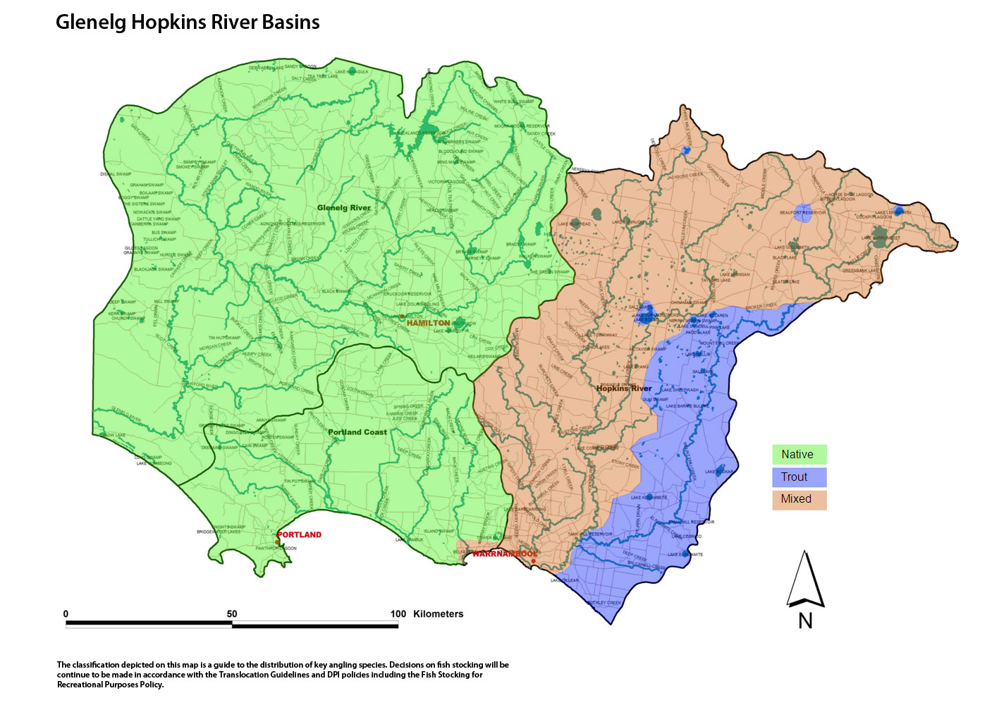
Map showing Glenelg Hopkins River Basins (click map for large version)
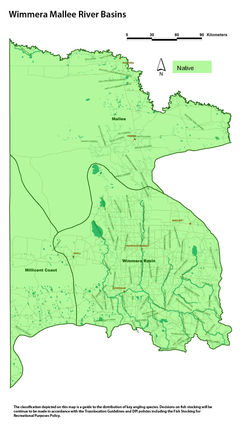
Map showing Wimmera Mallee River Basins (click map for large version)
Hopkins Basin
Preliminary assessment
Species evidence
Estuary perch, black bream, river blackfish, southern shortfin eel, brown trout, rainbow trout, redfin.
Known range of angling species
Lake Burrumbeet - brown trout, redfin, eels.
Merri River downstream Bromfield St Weir (Wollaston Weir) - brown trout, estuary perch, black bream, mullet, Australian salmon and short-finned eel.
Merri River upstream of Bromfield St Weir (Wollaston Weir) - brown trout, river blackfish.
Mount Emu Creek and Hopkins River - river blackfish, shortfin eel and brown trout.
Hopkins River estuary - estuary perch, black bream, mulloway and other native estuarine species.
Hopkins and Merri rivers and tributaries - shortfin eel, brown trout.
Waterway management
The Glenelg Hopkins Catchment Management Authority manages waterways in the Region through the Glenelg Hopkins River Health Strategy. Activities undertaken through the Strategy include habitat improvement through erosion control, bed and bank stabilization, willow and weed removal, fencing and replanting banks.
The Western Region Sustainable Water Strategy is currently in preparation and will respond to pressures facing water resources including climate change, drought, and land use change. The strategy aims to secure water for towns, industry, the environment and agriculture for the next 50 years.
The Hopkins River estuary is a Premier River because it can provide high quality, accessible and sustainable fishing for developing and experienced anglers. The Hopkins River estuary was selected to be developed and promoted as a Premier River through the Go Fishing in Victoria initiative to enhance the social and economic contribution of fishing to Victorian communities.
Ramsar site – Lake Bookar.
Threatened fish species
Australian grayling, Yarra pygmy perch, Portland burrowing crayfish, hairy burrowing crayfish and dwarf galaxias.
Socio-economic value
Hopkins River estuary - estuary perch, black bream.
Lower Merri including the estuary - brown trout, black bream, and estuary perch, yellow-eye mullet.
Lake Burrumbeet - redfin, brown trout and eels.
Beaufort Lake – brown trout.
Greenhill Lake – brown trout.
Criteria assessment
Flow
Unregulated.
Habitat
This basin is mostly cleared for agriculture except for small areas of low mixed-species forest north of Beaufort. All the rivers flow through grassland and riparian tree cover is usually absent apart from scattered individual trees.
The absence of forest, the predominance of finely textured soils and low rainfall results in slow-flowing, mud-bottom streams with relatively high summer salinity. The numerous lakes provide excellent fishing.
Identifiable structures
Merri River weir.
Bromfield St Weir (Wollaston Weir).
Princes, Glenelg and Hopkins highways.
Classification
Trout - Merri River downstream of Drysdale Creek to Princes Highway, Mount Emu Creek from Hopkins River junction to Skipton.
Mixed - all other waters including Hopkins River downstream of the Hopkins Falls and Merri River downstream of Bromfield Weir
Portland Basin
Preliminary assessment
Species evidence
Estuary perch, river blackfish, southern shortfin eel, brown trout, rainbow trout, redfin.
Known range of angling species
Surry, Fitzroy, Eumerella, Shaw and Moyne rivers and Darlots Creek - shortfin eels, redfin, tupong, river blackfish and brown trout.
Yambuk Lake, Fitzroy, Moyne, Surrey and Eumerella river estuaries - black bream, mullet, Australian salmon, estuary perch and flounder.
Aringa Reservoir - brown and rainbow trout.
Waterway management
The Glenelg Hopkins River Health Strategy guides waterway management and is implemented by the Glenelg Hopkins Catchment Management Authority. Activities undertaken through the Strategy include habitat improvement through erosion control, bed and bank stabilization, willow and weed removal, fencing and replanting banks.
The Western Region Sustainable Water Strategy is currently in preparation and will respond to pressures facing water resources including climate change, drought, and land use change. The strategy aims to secure water for towns, industry, the environment and agriculture for the next 50 years.
Threatened fish species
Yarra pygmy perch, dwarf galaxias, Portland burrowing crayfish, Glenelg spiny crayfish, hairy burrowing crayfish.
Socio-economic value
Aringa Reservoir - brown trout, rainbow trout.
Yambuk Lake & Fitzroy River estuary - black bream, yellow-eye mullet, Australian salmon, estuary perch and flounder.
Moyne River – brown trout, and estuarine species in estuary.
Criteria assessment
Flow
Unregulated.
Habitat
The Portland Basin is primarily a flat volcanic plain with a coastal strip of dune complex. Land use is primarily grazing and broad acre cropping. The Surry River, Fitzroy River, Darlots Creek, Eumerella River, Shaw River and Moyne River are the main freshwater rivers in this basin.
Most rivers of the Portland Coastal Basin are in poor environmental condition having limited riparian vegetation, elevated nutrients and elevated salinity.
Freshwater sections of these rivers support populations of shortfin eels, tupong and river blackfish. Some of the rivers also support small populations of brown trout.
Identifiable structures
Not applicable.
Classification
Trout - Aringa Reservoir.
Native - all other waters.
Mixed – Moyne River.
Glenelg Basin
Preliminary assessment
Species evidence
Estuary perch, Australian bass, river blackfish, shortfin eel, brown trout, rainbow trout, tupong, redfin.
Known range of angling species
Trout fishing is largely dependent on stocking.
Blackfish - Kangaroo and Muddy creeks, Stokes, Crawford, Glenelg and Wannon rivers, Mombeong Lake, Rocklands Reservoir.
Glenelg estuary - Estuary perch, black bream, yellow-eye mullet, Australian salmon, mulloway, luderick, flathead and flounder.
Glenelg estuary and Glenelg River to Casterton - estuary perch and rainbow trout.
Glenelg River – Australian bass and rainbow trout.
Waterway management
The Glenelg Hopkins Catchment Management Authority manages the waterways in the region through the Glenelg Hopkins River Health Strategy. Activities undertaken through the Strategy include erosion control, bed and bank stabilization, willow and weed removal, fencing and replanting banks. Works have been carried out on numerous waterways in this basin.
The Western Region Sustainable Water Strategy is currently in preparation and will respond to pressures facing water resources including climate change, drought, and land use change. The strategy aims to secure water for towns, industry, the environment and agriculture for the next 50 years.
Heritage River - The Glenelg River from Dartmoor to the sea (excluding the section in South Australia).
Threatened fish species
Dwarf galaxias, Yarra pygmy perch, variegated pygmy perch, Glenelg spiny crayfish, Glenelg freshwater mussel, Australian grayling, Portland burrowing crayfish and Macquarie perch.
Socio-economic value
Waters valued for angling for trout include - the Konong Wootong and Rocklands reservoirs, Lake Hamilton and the Family Fishing Lakes.
Waters valued for angling for native species include - Glenelg River and Glenelg River estuary.
Criteria assessment
Flow
Unregulated apart from Glenelg below Rocklands Reservoir.
Habitat
Many waterways in this basin including the Glenelg and Wannon Rivers carry elevated sediment loads from erosion of tributary streams. The Glenelg River downstream of Rocklands Reservoir to Dartmoor has almost continuous riparian vegetation of mature gums along both banks.
The Wannon River downstream to the Wannon Falls on the Glenelg Highway is in good, moderate and excellent condition at various localities. It is in poor condition downstream of Tahara deteriorates towards the Glenelg River because of sedimentation.
The top of the Glenelg River estuary has sedimentation but habitat further downstream in the Lower Glenelg National Park is in excellent condition.
Identifiable structures
Rocklands Reservoir
Classification
Mixed - Rocklands Reservoir, Konong Wootong Reservoir (Lake) and Lake Hamilton
Native - all other waters.
Millicent Basin
Preliminary assessment
Species evidence
Murray cod, golden perch, brown and rainbow trout, redfin.
Known range of angling species
Bringalbert Lake, Carpolac Lake, Charlegark Lake and Miga Lake - Murray cod, golden perch.
Wallace Lake - brown and rainbow trout.
Mosquito Creek - brown and rainbow trout
Waterway management
The Glenelg Hopkins Catchment Management Authority manages the waterways in the region through the Glenelg Hopkins River Health Strategy. No activities have been undertaken in this basin.
The Western Region Sustainable Water Strategy is currently in preparation and will respond to pressures facing water resources including climate change, drought, and land use change. The strategy aims to secure water for towns, industry, the environment and agriculture for the next 50 years.
Threatened fish species
Murray cod, Australian mudfish and Yarra pygmy perch.
A Governor in Council order allows anglers to take Murray cod.
Socio-economic value
Lake Charlegark and Booroopki Swamp - Murray cod.
Wallace Lake - brown and rainbow trout.
Criteria assessment
Flow
Not applicable.
Habitat
This basin is mainly located in South Australia. The small area extending into Victoria includes a sand dune complex with mallee, saltbush and heathland scrub, some farmland and scattered low forest. Surface water consists of a large number of shallow, brackish lakes and swamps and the upper reaches of Mosquito Creek. Only a few waters are suitable for angling. Murray cod and golden perch have been introduced into a number of waters.
Identifiable structures
Not applicable.
Classification
Trout - Wallace Lake.
Native - all other waters.
Mallee Basin
Preliminary assessment
Species evidence
Murray cod, golden perch, Murray spiny crayfish, silver perch freshwater catfish, redfin.
Known range of angling species
Murray cod, golden perch, silver perch, yabby and freshwater catfish.
Waterway management
The Mallee Catchment Management Authority manages the waterways in the region through the Mallee River Health Strategy. Environmental flood flows for red gum forests were provided for Lindsay and Walpolla islands and Hattah Lakes as part of the Regional River Health Strategy.
The Western Region Sustainable Water Strategy is currently in preparation and will respond to pressures facing water resources including climate change, drought, and land use change. The strategy aims to secure water for towns, industry, the environment and agriculture for the next 50 years.
Ramsar sites - Lakes Bitterang, Cantala, Konardin, Yelwell, Yerang, Mournpall, Bulla, Hattah, Arawak, Brockie and Kramen in the Hattah-Kulkyne National Park.
Threatened fish species
Murray cod, freshwater catfish, Murray hardyhead, Murray River rainbowfish, silver perch, unspecked hardyhead, southern purple-spotted gudgeon and Murray spiny crayfish.
Murray cod, silver perch freshwater catfish and Murray spiny crayfish - a Governor in Council order allows anglers to take Murray cod and Murray spiny crayfish from any water and silver perch only from lakes or impoundments in this Basin.
Socio-economic value
Waters valued for angling for native species such as golden perch and Murray cod include - Cullulleraine Lake, Lindsay and Mullaroo rivers, Walpolla Creek and the Hattah lakes when holding water.
Classification
Native - all waters.
Wimmera Basin
Preliminary assessment
Species evidence
Golden perch, Murray cod, freshwater catfish, silver perch, river blackfish, brown trout, rainbow trout, redfin.
Known range of angling species
Wimmera River and tributaries - freshwater catfish, redfin, golden perch, silver perch, Murray cod.
Richardson River - golden perch, freshwater catfish, Murray Cod, and redfin.
MacKenzie River - trout, blackfish and redfin.
Upper Wimmera River creeks and streams - blackfish, redfin.
Mount William and Burnt Creek - blackfish, golden perch and redfin.
Lakes Lonsdale, Taylors, Hindmarsh, Albacutya and Buloke - yabbies.
Lake Hindmarsh - yabbies, redfin and golden perch.
Rich Avon weir pool on the Richardson River near Marnoo – redfin, Murray cod, golden perch.
Lakes Bellfield, Fyans, Wartook and Toolondo – brown and rainbow trout, redfin.
MacKenzie River between Horsham Water Supply channel diversion weir (Dad & Dave's Weir) and the outlet of Lake Wartook – brown trout and blackfish.
Fyans Creek - brown trout, rainbow trout (blackfish?) and redfin.
Waterway management
The Wimmera Catchment Management Authority manages waters in the region through the Wimmera River Health Strategy. Activities undertaken through the Strategy include habitat improvement in the headwaters of the Wimmera River, in the McKenzie Creek and the Avon-Richardson river.
The Western Region Sustainable Water Strategy is currently in preparation and will respond to pressures facing water resources including climate change, drought, and land use change. The strategy aims to secure water for towns, industry, the environment and agriculture for the next 50 years.
Heritage River - Wimmera River from Polkemmet Bridge to Wirrengren Plain.
Threatened fish species
Murray cod, silver perch, freshwater catfish. A Governor in Council order allows anglers to take Murray cod, freshwater catfish and silver perch from waters in this Basin.
Socio-economic value
The Wimmera Basin is of statewide significance because it is the only area of Victoria where anglers are legally permitted to take catfish. It has significant populations of Murray cod, golden perch, redfin and brown and rainbow trout.
Waters valued for angling for native species such as freshwater catfish, golden perch, Murray cod - Wimmera River both downstream of Horsham and lakes Taylor and Hindmarsh.
Waters valued for angling for trout include lakes Fyans, Wartook and Toolondo Reservoir. Other waters stocked by Fisheries when conditions are suitable, such as Lake Natimuk, are periodically important.
Rich Avon weir pool on the Richardson River near Marnoo – redfin, Murray cod, golden perch.
Waters valued for redfin include – lakes Lonsdale, Wartook, Toolondo and Fyans.
Criteria assessment
Flow
Regulated.
Habitat
Most waters in the region originate in the southern Pyrenees and Grampian ranges and flow north via the Wimmera and Avon-Richardson rivers. Flows are reduced north of the Wimmera Plains, through upper catchment water harvesting, diversion and consumptive use in the Wimmera River and tributaries. Lake
Hindmarsh periodically receives water from the Wimmera River and the terminal Buloke lakes occasionally receive water from both the Avon and Richardson river catchments.
The Basin has several large natural lakes and four man-made storages, located south of Horsham. These contain trout from regular stocking and self-sustaining populations of redfin. Murray cod, silver perch, golden perch and catfish have also been introduced into lakes in the Basin.
Identifiable structures
Not applicable.
Classification
Mixed - Lakes Bellfield, Fyans, Wartook and Toolondo, and other impoundments periodically stocked with trout by Fisheries Victoria through Vic Fish Stock. McKenzie River upstream of Horsham Water Supply channel diversion weir (Dad & Dave's Weir), and Fyans Creek.
Native - other all waters.