Central Region
The Central region encompasses all waters south of the Great Dividing Range and includes the inland waters surrounding Port Phillip Bay and Western Port including the basins of Bunyip, Yarra, Maribyrnong, Werribee, Barwon and Moorabool rivers.
Popular angling species in the region include brown and rainbow trout, black bream, Australian bass, estuary perch, redfin and a range of other estuarine species. Also highly valued are native species which have been moved into the region from the north of the state including populations of golden perch, Murray cod and Macquarie perch.
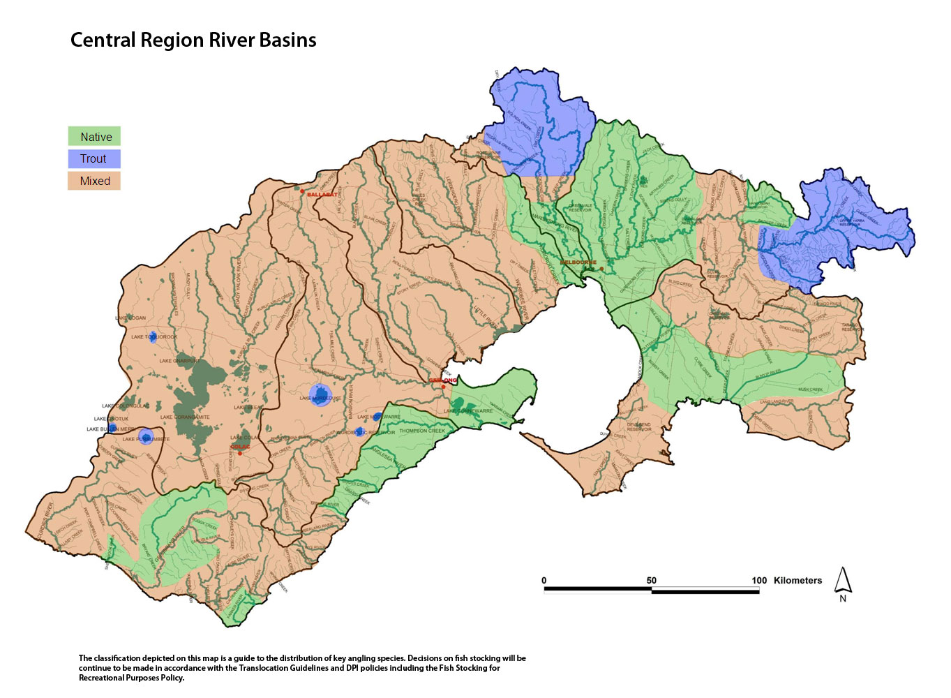
Map showing Central Region River Basins (click map for large version)
Bunyip Basin
Preliminary assessment
Species evidence
Black bream, mullet, brown and rainbow trout, redfin, Gippsland spiny crayfish, longfin eel, river blackfish, southern shortfin eel and Yarra spiny crayfish.
Known range of angling species
Tyers River - brown trout and river blackfish.
Main Creek - brown trout, southern shortfin eel, river blackfish.
Bunyip Creek - brown and rainbow trout, river blackfish.
Lang Lang River - brown and rainbow trout, river blackfish, southern shortfin eel, redfin, Gippsland spiny crayfish.
Waterway management
The Port Phillip and Westernport Regional River Health Strategy guides waterway management. Activities undertaken through the Strategy include removal of willow and pest plants and the protection of banks by fencing, re-establishing native vegetation and engineering works in the Cardinia and Deep creeks and the Lang Lang River.
Cardinia and Tarago reservoirs are domestic water storages managed by Melbourne Water and are closed to angling.
The Central Region Sustainable Water Strategy is a plan to secure water supplies for homes, business, industry, agriculture and the environment for the next 50 years. The Strategy sets out a plan to meet the water needs of towns, industry, farms and the environment in the context of growing populations, the uncertainty of climate change, land use changes and drought.
Threatened fish species
Australian grayling, dwarf galaxias, Australian mudfish, Warragul burrowing crayfish, Dandenong burrowing crayfish, Narracan burrowing crayfish, foothill burrowing crayfish.
Socio-economic value
Waters valued for angling for trout include - the Bunyip river upstream of the Princes Highway and Tarago River both upstream and downstream of Tarago Reservoir.
Waters valued for angling for native species include - Bunyip River upstream of the Princes Highway and Tarago River both upstream and downstream of Tarago Reservoir.
Criteria assessment
Flow
Regulated.
Habitat
The larger rivers originate in steep mountains on the northern and eastern sides of the Basin and flow through extensive plains and discharge into Western Port.
Most of the Basin has been cleared for agriculture with intensive irrigation and cropping in the south, particularly on Mornington Peninsula, which has many vineyards irrigated from local streams.
Identifiable structures
Not applicable.
Classification
Mixed - Waters north of Princes Highway including Tarago and Bunyip rivers and tributaries, Dandenong, Cardinia, Cannibal and Labertouche creeks. Waters south west of Dandenong Hasting Road including Main, Stony, Merricks and Balcombe creeks and Devilbend Reservoir.
Native - Waters south of Princes Highway including Cardinia, Toomuc and Yaloak creeks, Main Drain, and Lang Lang and Paterson rivers.
Yarra Basin
Preliminary assessment
Species evidence
Australian bass, golden perch, Macquarie perch, Murray cod, brown trout, rainbow trout, redfin, Gippsland spiny crayfish, river blackfish, Yarra spiny crayfish, snapper, mulloway, Australian salmon, black bream, mullet.
Known range of angling species
Yarra River upstream of Warburton - blackfish.
Yarra River upstream of Warburton - brown trout.
Yarra River between Warburton and Melba Highway - Macquarie perch, Murray cod, blackfish, brown trout.
Yarra River between Melba Highway and Dights falls - Macquarie perch, golden perch, Murray cod and brown trout.
Yarra River estuary to Dights falls - black bream, mulloway, snapper, trevally, mullet, Australian salmon, Australian bass.
Natural Catchment Area around Maroondah Reservoir including Badger Creek currently believed to not contain trout.
Sugarloaf Reservoir - brown trout and golden perch.
Waterway management
The Central Region Sustainable Water Strategy is a plan to secure water supplies for homes, business, industry, agriculture and the environment for the next 50 years. The Strategy sets out a plan to meet the water needs of towns, industry, farms and the environment in the context of growing populations, the uncertainty of climate change, land use changes and drought.
Heritage River - Yarra River from Warburton to Templestowe.
Natural Catchment Area - upper reaches of the O'Shannassy River.
Threatened fish species
Australian mudfish, Australian grayling, dwarf galaxias, Macquarie perch, Murray cod, Dandenong burrowing crayfish, Gippsland burrowing crayfish, tubercle burrowing crayfish, foothill burrowing crayfish and Yarra pygmy perch. An order has been made under Flora and Fauna Guarantee Act to allow anglers to take Macquarie perch and Murray cod within the Yarra Basin.
Socio-economic value
Waters valued for angling for trout include - the Yarra River upstream of Launching Place and the Family Fishing Lakes.
Waters valued for angling for native species include - the Yarra River including areas upstream and downstream of Warburton and around Warrandyte and Melbourne.
Lillydale Lake is a Premier Lake which is regularly stocked with large rainbow trout to provide opportunities for those new to fishing to try their luck.
Criteria assessment
Flow
Regulated.
Habitat
The Yarra River originates upstream of the Upper Yarra Reservoir in steep forest closed to fishing. The Yarra flows through forested areas upstream of Warburton and then into agricultural land and finally into urbanised areas and into Port Phillip Bay.
Identifiable structures
Melba Highway, Warburton, Yarra Junction.
Classification
Trout - Yarra and tributaries upstream of Launching Place including Don, Hoddles and Dee creeks and Little Yarra and tributaries from Yarra Junction.
Mixed - Yarra and tributaries from Melba Highway Warburton including Woori Yallock, McCrae, Shepphard, New Chum and Paul creeks.
Native - Yarra and tributaries from estuary to Melba Highway. Maroondah Reservoir and Badger Creek area around Healesville.
Maribyrnong Basin
Preliminary assessment
Species evidence
Brown trout, rainbow trout, redfin, blackfish, southern shortfin eel, estuary perch and other estuarine species.
Known range of angling species
Maribyrnong River from Solomons Ford to Yarra River estuary - estuary perch, black bream, silver trevally, mullet, flathead, pinkie snapper and mulloway and other estuarine species.
Maribyrnong River and tributaries upstream of Solomons Ford - shortfin eels and brown trout.
Jacksons, Riddells and Deep creeks - short-finned eels and brown trout.
Waterway management
Melbourne Water manages waterways through the regional Port Phillip and Westernport River Health Strategy and undertakes activities including erosion control, bed and bank stabilization, willow and weed removal, fencing and replanting banks and provision of fish passage.
Most waterways flow through private property, and due to settlement largely taking place before Crown Land Frontage was implemented, ownership often extends to the top of the bank or mid stream.
The Central Region Sustainable Water Strategy is a plan to secure water supplies for homes, business, industry, agriculture and the environment for the next 50 years. The Strategy sets out a plan to meet the water needs of towns, industry, farms and the environment in the context of growing populations, the uncertainty of climate change, land use changes and drought.
Threatened fish species
Australian grayling and Yarra pygmy perch (Deep Creek upstream of Lancefield).
Socio-economic value
Waters valued for angling for mixed species include - Maribyrnong River above Solomons Ford and tributaries including Deep, creeks and particularly Jacksons Creek downstream of Riddells Creek junction.
Waters valued for angling for native species include - Maribyrnong River downstream of Solomons Ford.
Criteria assessment
Flow
Unregulated - Deep Creek.
Regulated - Maribyrnong River and Jacksons creek.
Habitat
River flows in a deep valley through cleared farmland and Melbourne suburbs. Substrate is mud, sand, rock and boulders. Very extensive pools with sluggish flow and discoloured water.
Identifiable structures
Solomons Ford, Donnybrook Road, Calder Highway.
Classification
Native - Maribyrnong downstream of Bulla.
Mixed - Jacksons Creek upstream of Gisbourne, streams between Bulla and Clarkfield.
Trout – all other waters.
Werribee Basin
Preliminary assessment
Species evidence
Shortfin eel, river blackfish, brown trout,
Known range of angling species
Lerderderg River upstream of Blackwood - brown trout, shortfin eel, blackfish.
Werribee River and tributaries above Melton Reservoir – brown trout, blackfish and redfin.
Werribee River downstream of Melton Reservoir - shortfin eel.
Werribee River estuary - black bream, mulloway, mullet, snapper, some flathead and other estuarine species.
Kororoit Creek estuary - black bream, mulloway, mullet, snapper and other estuarine species.
Kororoit Creek - shortfin eel.
Waterway management
Melbourne Water manages waterways through the regional Port Phillip and Westernport River Health Strategy and undertakes activities including erosion control, bed and bank stabilization, willow and weed removal, fencing and replanting banks and provision of fish passage.
The Central Region Sustainable Water Strategy is a plan to secure water supplies for homes, business, industry, agriculture and the environment for the next 50 years. The Strategy sets out a plan to meet the water needs of towns, industry, farms and the environment in the context of growing populations, the uncertainty of climate change, land use changes and drought.
Heritage River - Lerderderg River downstream of Roach Road and the boundary of the southern extremity of Lerderderg State Park.
Representative River - The Lerderderg River, at O'Briens Crossing, has been listed as a Representative River of West Victorian dissected uplands, volcanic plains.
Ramsar - western shoreline of Port Phillip Bay, which is the receiving body for all water flowing out of this Basin.
Threatened fish species
Australian Mudfish.
Socio-economic value
Waters valued for angling for native species include - Werribee River downstream of Melton Reservoir including Werribee River estuary.
Waters valued for angling for mixed species include - Lerderderg River upstream of Blackwood.
Waters valued for angling for trout species include - Pykes Creek Reservoir and Lerderderg and Werribee rivers.
Classification
Native - Kororoit Creek.
Mixed - all other waters.
Moorabool Basin
Preliminary assessment
Species evidence
Brown and rainbow trout, redfin, river blackfish, shortfin eel.
Known range of angling species
Hovell Creek - shortfin eel, redfin, tupong and estuarine species including black bream, flathead, silver trevally and snapper.
Moorabool River including east and west branch - brown trout, shortfin eel, river blackfish and redfin.
Waterway management
The Corangamite Catchment Management Authority manages waterways in the region through the Corangamite Regional River Health Strategy and undertakes activities including erosion control, bed and bank stabilization, willow and weed removal, fencing and replanting banks and provision of fish passage, primarily in the Moorabool River.
The Central Region Sustainable Water Strategy is a plan to secure water supplies for homes, business, industry, agriculture and the environment for the next 50 years. The Strategy sets out a plan to meet the water needs of towns, industry, farms and the environment in the context of growing populations, the uncertainty of climate change, land use changes and drought.
Representative River - Moorabool River east branch is a volcanic plains, west Victorian dissected uplands river.
Ramsar - western shoreline of Port Phillip Bay, which is the receiving body for all water flowing out of this Basin.
Threatened fish species
Australian grayling, Yarra pygmy perch.
Socio-economic value
Bostock Reservoir - trout.
Moorabool Reservoir - trout.
Moorabool River between Bungal Dam and Sheoaks - brown trout.
Hovell Creek estuary - black bream.
Criteria assessment
Flow
Regulated.
Habitat
The Moorabool River rises as two major tributaries on the southern slopes of the Great Dividing Range near Ballan and flows in a southeast direction joining the Barwon River near Geelong. There is intensive, irrigated cropping in the headwaters, but most of the river flows through open farmland used for grazing and broad acre cropping.
Flow in the Moorabool River is controlled by releases from Lal Lal Reservoir (Bungal Dam) and Bostock Reservoir and flow in the southern streams is generally low during summer and autumn.
Identifiable structures
Not applicable.
Classification
Mixed - all waters.
Barwon Basin
Preliminary assessment
Species evidence
Brown trout, river blackfish, shortfin eel, black bream, Australian salmon, sand mullet, mullet, flathead, silver trevally, black bream, King George whiting, mulloway.
Known range of angling species
Barwon River from Forrest to Lake Connewarre - brown trout, river blackfish, redfin, shortfin eel.
Barwon River downstream of Lake Connewarre - Australian salmon, sand mullet, mullet, flathead, silver trevally, black bream and King George whiting, mulloway, brown trout, redfin, flounder, sea mullet, tupong, silver trevally, estuary perch, luderick, shorthead lamprey, King George whiting and tailor.
Lakes Modewarre Murdeduke, Wurdee Boluc and Wendouree and West Barwon Reservoir - brown trout and rainbow trout.
Waterway management
The Corangamite Catchment Management Authority manages waterways in the region through the Corangamite Regional River Health Strategy and undertakes activities including erosion control, bed and bank stabilization, willow and weed removal, fencing and replanting banks and provision of fish passage, primarily in the Barwon River.
The Central Region Sustainable Water Strategy is a plan to secure water supplies for homes, business, industry, agriculture and the environment for the next 50 years. The Strategy sets out a plan to meet the water needs of towns, industry, farms and the environment in the context of growing populations, the uncertainty of climate change, land use changes and drought.
Ramsar - western shoreline of Port Phillip Bay, which is the receiving body for all water flowing out of this Basin.
Threatened fish species
Australian grayling, Yarra pygmy perch, Australian mudfish, dwarf galaxid, Otways crayfish, western burrowing crayfish, hairy burrowing crayfish.
Socio-economic value
Barwon River estuary - estuarine species.
Barwon River above estuary (above Buckleys falls) - brown trout, shortfin eel, and redfin.
Yarrowee (Leigh) River – brown trout.
Lake Wendouree - brown and rainbow trout.
Wurdee Boluc, Modewarre and Murdeduke lakes, Gong Gong and West Barwon reservoirs when water levels are appropriate to support fish, and the Family Fishing lakes - trout.
Criteria assessment
Flow
Regulated.
Habitat
The Barwon River flows through southern end of the Basin and through Geelong. It rises in steep, forested mountains in the Otway Ranges upstream of Forrest and descends quickly into flat farmland of the western basalt plain. Salinity is the major water quality problem and the Barwon River has little riparian vegetation except for some sections with river red gums and willows, but rushes and sedges are abundant in most localities.
Outcrops of basalt rock particularly around Inverleigh, Pollocksford and at Buckleys Falls create rapids and cascades. The lower reaches experience extended periods of very low flow during summer and autumn. There are numerous deep pools, particularly in the lower reaches of the Barwon River, which provide permanent habitat supporting good fish populations.
Identifiable structures
Buckley's Falls, Lake Connewarre.
Classification
Trout – Wurdee Boluc, Modewarre, Wendouree and Murdeduke lakes, Gong Gong and West Barwon reservoirs and the Family Fishing lakes.
Native - below Lake Connewarre.
Mixed - all other waters.
Corangamite Basin
Preliminary assessment
Species evidence
Australian bass, golden perch, river blackfish, silver perch and short-finned eel, Atlantic salmon, brown trout, Chinook salmon, redfin, rainbow trout.
Known range of angling species
Lake Bullen Merri – trout, Chinook salmon and Australian bass.
Lake Tooliorook - trout and eel.
Woady Yaloak Creek - trout, redfin, eel, blackfish.
Waterway management
The Corangamite Catchment Management Authority manages waterways in the region through the Corangamite River Health Strategy and undertakes activities including erosion control, bed and bank stabilisation, willow and weed removal, fencing and replanting banks. Work has primarily been undertaken at Lake Bullen Merri, Lake Colac and on the Woady Yaloak River.
The Western Region Sustainable Water Strategy is a plan to secure water supplies for homes, business, industry, agriculture and the environment for the next 50 years. The Strategy sets out a plan to meet the water needs of towns, industry, farms and the environment in the context of growing populations, the uncertainty of climate change, land use changes and drought.
Ramsar - Lake Beeac, Lake Corangamite, Lake Colongulac, Lake Cundare, Lake Gnarpurt, Lake Milangil and Lake Terangpom.
Threatened fish species
Yarra pygmy perch, mountain galaxias, hairy burrowing crayfish.
Socio-economic value
Lake Bullen Merri – trout, Australian bass and salmonid species.
Lake Tooliorook (Ettrick) - trout and eel.
Woady Yaloak River - trout, redfin, eel, blackfish.
Criteria assessment
Flow
Regulated.
Habitat
Woady Yaloak Creek is the largest waterway in the basin and flows into the highly saline Lake Corangamite. Lake Bullen Merri is a deep, brackish lake enclosed in a volcanic crater. The catchment includes mixed species forest in the northern hills and southwest of Lake Corangamite and the remainder of the basin is grazing or broad acre cropping. There is no riparian tree cover except along the upper Woady Yaloak River and sections of Kuruc-A-Ruc Creek.
Identifiable structures
Not applicable
Classification
Mixed - all waters.
Trout - Bullen Merri and Tooliorook (Ettrick) lakes. Although Bullen Merri is classified as 'Trout', this does not preclude stocking of other salmonids such as Chinook or Atlantic salmon where such a decision is made through the Vic Fish Stock process.
Otway Basin
Preliminary assessment
Species evidence
Estuary perch, black bream, river blackfish, and short-finned eel, redfin, Atlantic salmon, brown and rainbow trout, Chinook salmon.
Known range of angling species
Rivers and creeks east of Cape Otway - brown trout, shortfin eels.
Estuaries of rivers and creeks - black bream, estuary perch, mullet, Australian salmon and flounder.
Gellibrand and Carlisle rivers and tributaries and Kennedy's, Sandy, Chapple creeks and tributaries - blackfish, brown trout and eels.
Aire River and tributaries including Ford River - brown trout.
Aire River estuary including Lake Hordon - estuary perch, black bream, mullet, brown trout and shortfin eel.
Lake Purrumbete – brown and rainbow trout, Chinook salmon, redfin and eels.
Lake Elingamite – brown trout, redfin and eels.
Curdies River – Estuarine species, brown trout, redfin and eels.
Waterway management
The Corangamite Catchment Management Authority manages waterways in the region through the Corangamite River Health Strategy and undertakes activities erosion control, bed and bank stabilization, willow and weed removal, fencing and replanting banks, restoring fish passage, habitat and improving angler access in selected waters. Work has taken place in the Barham, Curdies, Gellibrand and Wye Rivers.
The Western Region Sustainable Water Strategy is currently in preparation and will respond to pressures facing water resources including climate change, drought, and land use change. The strategy aims to secure water for towns, industry, the environment and agriculture for the next 50 years.
Representative Rivers - Kennedy Creek a tributary of the Gellibrand River has been listed as a Representative River of dissected coastal plains, volcanic plains. The Gellibrand River upstream of Carlisle has been listed as a Representative River for Otway Ranges, dissected plains. The entire length of the Aire River is recognised as a Representative River.
Heritage River - Aire River from Hopetown Falls to the sea.
Threatened fish species
Australian grayling, Australian mudfish, Yarra pygmy perch, Otway burrowing crayfish, hairy burrowing crayfish.
Socio-economic value
Purrumbete Lake - trout, eel, redfin.
Gellibrand and Carlisle rivers and tributaries - river blackfish and brown trout.
Aire River and tributaries including Ford River - brown trout.
Aire River estuary including Lake Hordon - estuarine species, brown trout and shortfin eel.
Lake Elingamite – trout, redfin
Otway coastal streams from and including Barham River to and including Erskine River – brown trout, estuarine species in estuaries.
Curdies River – estuarine species
Criteria assessment
Flow
Unregulated.
Habitat
The Otway Ranges in the basin are a large area of moderate to steep forested hills and all the larger streams drain from the ranges southern slopes into the sea, east and west of Cape Otway. The remainder of the Basin is all cleared farmland. There are two large rivers, the Gellibrand and the Curdies. Other waterways are small streams flowing a short distance from forested hills to the sea. They have high gradients and are characterized by cascades and rapids, with coarse substrates and small estuaries.
Identifiable structures
Lavers Hill to Colac Road, Princetown Road, Great Ocean Road.
Classification
Trout - Lake Elingamite and Lake Purrumbete. Although these lakes are classified as 'Trout', this does not preclude stocking of other salmonid species such as Chinook or Atlantic salmon where other conditions are met.\
Native - Barwon Heads Road to Erskine River and Gellibrand and Carlisle tributaries including Chapple, Sandy, Boggy, Cole, Bryant and Kennedys creeks.
Mixed – Gellibrand and Carlisle rivers and Lardners Creek and all other waters. Aire, Gellibrand and Ford rivers – downstream of the Great Ocean Road Bridge.