Eastern Port Phillip Management Plan - Appendices
Return to main article, 'Eastern Port Phillip Bay Aquaculture Fisheries Reserves Management Plan'
Appendix 1: The Ministerial guidelines for the preparation of Fisheries Reserve Management Plans
Appendix 2: Acronyms and abbreviations
Appendix 5: Detailed description of the attributes of the Dromana Aquaculture Fisheries Reserve
Appendix 6: Detailed description of the attributes of the Mount Martha Aquaculture Fisheries Reserve
Appendix 7: Detailed description of the attributes of the Beaumaris Aquaculture Fisheries Reserve
Appendix 8: Victorian Shellfish Quality Assurance Program (VSQAP) phytoplankton monitoring triggers
Appendix 9: Standing Committee members and affiliation
Appendix 10: Potential ecosystem impacts of bivalve mollusc and offshore abalone culture
Appendix 12: Transitional arrangements for existing licence holders
Appendix 1: The Ministerial guidelines for the preparation of Fisheries Reserve Management Plans
Geelong Arm Aquaculture Fisheries Reserves Management Plan Eastern Port Phillip Bay Aquaculture Fisheries Reserves Management Plan Flinders Aquaculture Fisheries Reserve Management Plan
- A Geelong Arm Aquaculture Fisheries Reserves Management Plan will be prepared in respect of the Bates Point Aquaculture Fisheries Reserve, Clifton Springs Aquaculture Fisheries Reserve, Grassy Point Aquaculture Fisheries Reserve and Kirk Point - Werribee Aquaculture Fisheries Reserve.
- An Eastern Port Phillip Bay Aquaculture Fisheries Reserves Management Plan will be prepared in respect of the Dromana Aquaculture Fisheries Reserve, Beaumaris Aquaculture Fisheries Reserve and Mount Martha Aquaculture Fisheries Reserve.
- A Flinders Aquaculture Fisheries Reserve Management plan will be prepared.
- Fisheries Victoria of the Department of Primary Industries will be responsible for the preparation of these Management Plans. These plans must be consistent with the objectives of the Fisheries Act 1995.
- The Fisheries Co-management Council will oversee the process for the preparation of these Management Plans, in consultation with the Aquaculture Fisheries Committee. The plans must comply with Part 3 of the Fisheries Act 1995, in particular sections 28(6), 30, 32 and 35 of the Act.
- The Management Plans shall be prepared with input from all major affected stakeholder groups including Fisheries Victoria, aquaculture interests, conservation interests, recreational fishing interests and commercial fishing interests.
- The Management Plans shall be consistent with the Victorian Government Response (2001) to the recommendations for marine aquaculture of the Environment Conservation Council in the final report of their Marine Coastal and Estuarine Investigation 2000.
- The Management Plans shall specify appropriate management controls with regard to commercial aquaculture equipment including visual amenity, identification, security and maintenance.
- The Management Plans shall specify the areas available for allocation within the reserves and also public access to the reserves.
- The Management Plans shall specify the requirements and responsibilities for navigational marking of the reserves and the navigational marking and survey of aquaculture sites allocated within the reserves.
- The Management Plans shall specify the requirements for holding Crown leases and criteria for the transfer, amalgamation, subdivision and subleasing within the fisheries reserves.
- The Management Plans shall specify the requirements for environmental monitoring of aquaculture operations by licence holders in the reserve. They will also determine processes for auditing of and reporting to the Victorian community on the outcomes of environmental monitoring relating to the reserves.
- The Management Plans shall specify the requirements of licence holders with regard to product quality assurance programs.
- The Management Plans will specify where appropriate, transitional arrangements from current to new management arrangements for existing aquaculture operators within the aquaculture fisheries reserves.
Appendix 2: Acronyms and abbreviations
µg Microgram(s)
µm Micrometre(s)
AFFA Department of Agriculture, Fisheries and Forestry
AMG Australian map grid
ANZECC Australian and New Zealand Environment Conservation Council
ANZFA Australian and New Zealand Food Authority (now Foods Standards Australia New Zealand)
AQIS Australian Quarantine Service
ARMCANZ Agriculture and Resource Management Council of Australia and New Zealand
ASQAAC Australian Shellfish Quality Assurance Advisory Committee
ASQAP Australian Shellfish Quality Assurance Program
BAFR Beaumaris Aquaculture Fisheries Reserve
BPAFR Bates Point Aquaculture Fisheries Reserve
C Carbon
C:N Carbon to nitrogen ratio
CSAFR Clifton Springs Aquaculture Fisheries Reserve
DAFR Dromana Aquaculture Fisheries Reserve
DO Dissolved oxygen
DPI Department of Primary Industries
DSE Department of Sustainability and Environment
ECC Environment Conservation Council
ENRC Environment and Natural Resources Committee
EPA Environment Protection Authority
EPBC Environment Protection and Biodiversity Conservation Act
ESD Ecologically Sustainable Development
FAFR Flinders Aquaculture Fisheries Reserve
FCC Fisheries Co-Management Council
FCR Food conversion ratio
FFG Flora and Fauna Guarantee Act
GDA Geocentric Datum of Australia
GPAFR Grassy Point Aquaculture Fisheries Reserve
h Hour(s)
ha Hectare(s)
km Kilometre(s)
KWAFR Kirk Point - Werribee Aquaculture Fisheries Reserve
m Metre(s)
MAFRI Marine and Freshwater Research Institute (now PIRVic)
MMAFR Mount Martha Aquaculture Fisheries Reserve
N Nitrogen
NRE Department of Natural Resources and Environment (former), now Department of Primary Industries and Department of Sustainability and Environment
°C Celsius
OIE Organisation Internationales des Epizootiques
ORP Oxidation reduction potential
PCAFR Pinnace Channel Aquaculture Fisheries Reserve
PIRVic Primary Industries Research Victoria Queenscliff Centre (formerly the Marine and Freshwater Resources Institute)
ppb parts per billion
PPB Port Phillip Bay
PPBEMP Port Phillip Bay Environmental Management Plan
ppm Parts per million
ppt Parts per thousand
PSA Particle size analysis
Redox Oxidation reduction
s Second(s)
sal Salinity
SEPP State Environmental Protection Policy
SIV Seafood Industry Victoria
temp Temperature
VNPA Victorian National Parks Association
VRCA Victorian Regional Channels Authority
VRFish the corporate name for the Victorian Recreational Fishing Peak-Body
VSQAP Victorian Shellfish Quality Assurance Program
WP Western Port
WSCZ Werribee Spat Collection Zone
Appendix 3: Definitions for the Eastern Port Phillip Bay Aquaculture Fisheries Reserves Management Plan
Abalone cage culture
The culture of abalone contained in mid-water and or movable cages located on the seafloor.
Abalone ranching
The non-contained culture of abalone on structures.
Active feeding
The use of harvested macroalgae and or artificial feeds in aquaculture.
Allocation
A process culminating in the issue of Crown leases over areas within an aquaculture fisheries reserve consistent with the Victorian Aquaculture fisheries reserves - leasing and licensing policy.
Artificial feeds
Feeds including pelleted formulated feeds, whole/trash fish and by-products used for aquaculture.
Baseline survey
An initial assessment of physico-chemical, environmental and biological attributes of the specific Crown lease site.
Biological reference site
Compliance points which are located outside the Crown lease/aquaculture licence site at a predetermined location and designed to be used as 'indicators' to clarify the extent of environmental impacts attributable to aquaculture activity within the Crown lease/aquaculture licence site.
Characterisation survey
A broad assessment of the habitat, physicochemical, environmental and biological attributes of new aquaculture areas, including extensions to existing areas.
Checkerboard design
An aquaculture fisheries reserve design in which the reserve is divided into equal sized square blocks (sites) and every alternate block is utilised for aquaculture, similar to the pattern on a checkerboard.
Compliance point
Those specific locations within the Crown lease/aquaculture licence site at which survey data and or samples will be measured/collected, typically along a specific transect. Biological Reference Sites are effectively compliance points which are located outside the Crown lease/aquaculture licence site at a predetermined location and designed to be used as 'indicators' to clarify the extent of environmental impacts attributable to aquaculture activity within the Crown lease/aquaculture licence site.
Crown lease site
The area of land specified on a Crown lease issued under the Land Act 1958.
Declaration of the Plan
A management plan may be declared by the Minister under section 28(1) of the Fisheries Act 1995.
Dredging spoil ground
An area set aside for the placement of sediment removed from commercial shipping channels by dredging.
Ecologically Sustainable Development
A term used to describe development that takes account of environmental sustainability, economic viability and social equity.
Epifauna
Animals that live on the sea floor, or attached to other animals or objects under water.
Fallow
Leave area uncultivated or move aquaculture cage to another area.
Food Conversion Ratio
The amount of food required to produce a certain amount of wet weight in an aquaculture species. Also expressed as a ratio.
Greenfield
A site/area not previously developed.
Infauna
Animals that live beneath the surface of the sea floor.
Licence site
The area specified on an aquaculture licence issued under section 43 of the Fisheries Act 1995 within which aquaculture activity is authorised.
Licensed Surveyor
A person whose name is entered on the Register of Licensed Surveyors as per the Surveying Act 2004.
Longline backbone
The length of longline that is available for the attachment of production substrate.
Management trigger
The status that is unacceptable and requires immediate remedial action.
Monitoring
Refers to ongoing assessment of physico-chemical, environmental and biological attributes of the aquaculture licence site(s).
Nutrient offset
A mechanism established through 'nutrient trading' whereby the addition of nutrients from one operation is offset by the removal of nutrients by another operation.
Performance indicators
Attributes to be measured in order to track the status of the FAFR relevant to the objectives.
Remediation action
An action undertaken to return the status to the target reference point.
Reference point
The status management wishes to achieve.
Stock
The aquaculture species specified in an Aquaculture Licence for culture.
Stocking rate
Stocking density includes both the number and biomass of a stocked species within a unit area or volume expressed as an average over one year.
Threatened
Under the EPBC Act, threatened species are listed under the following categories: Extinct; Extinct in the Wild; Critically Endangered; Endangered; Vulnerable; Lower Risk; or Data Deficient.
Translocation
Any human assisted movement of an aquatic organism.
Appendix 4: The Victorian Government response to the recommendations of the Final Report of the Environment Conservation Council's (ECC) Marine, Coastal and Estuarine Investigation (2000) for marine aquaculture in Victoria
- R40.
- Commercial finfish aquaculture should not be considered in Port Phillip Bay until preliminary trials have been conducted under the following conditions:
- the trials are undertaken according to the nutrient reduction plan as outlined in clause 12, Schedule F6 (Waters of Port Phillip Bay) of the State Environment Protection Policy (Waters of Victoria); and
- a detailed monitoring program, including monitoring of the ongoing net nutrient balance, is carried out by the Department of Natural Resources and Environment.
- Commercial operations should only be approved by the NRE after advising the Minister responsible for Fisheries and the Minister for Environment and Conservation that:
- the trial demonstrates that commercial operations can be carried out with no net additional nutrient input to Port Phillip Bay; and
- a mechanism is developed, and put in place, to ensure independent monitoring of the ongoing net nutrient balance of commercial finfish aquaculture operations in the bay.
Schedule F6 (Waters of Port Phillip Bay) of the State environment protection policy (Waters of Victoria) requires the annual nitrogen load to Port Phillip Bay to be reduced by 1000 tonnes by 2006, and development of a Port Phillip Bay Environmental Management Plan and associated Nutrient Reduction Plan. Any finfish aquaculture proposals will be required to conform to the Nutrient Reduction Plan.
Within this context, the application of nutrient offset mechanisms (through the establishment of 'nutrient trading' whereby the addition of nutrients from one operation is offset by the removal of nutrients by another operation) will be investigated. In addition, as nitrogen is the key limiting nutrient for biological processes in the Bay, the focus of any offsetting/trading will be on nitrogen rather than other nutrients, such as phosphorus. Under any offset/trading scheme, purchasers of offsets will need to ensure best practice approaches are used to minimise nutrient inputs.
Commercial finfish aquaculture in Port Phillip Bay will only be considered if it can be demonstrated through peer-reviewed scientific research that nutrient management can be implemented successfully and without detriment to the environmental values of the Bay.
During the current review of the State environment protection policy (Waters of Victoria), EPA will consider including specific provisions in relation to waste minimisation requirements of aquaculture.
- R41.
- Each aquaculture area be subject to preparation of a management plan, including:
- specification of baseline and ongoing environmental monitoring requirements;
- access to the zone by other users;
- design, construction, maintenance and visual impact of structures; and
- any additional requirements for individual areas noted in recommendations E1 to E12 below.
It is proposed that aquaculture zones be declared as fisheries reserves under Section 88 of the Fisheries Act 1995. As prescribed by Section 89 of the Act, a Management Plan must be prepared. The purpose of a Management Plan is to specify policies and strategies to ensure the ecological sustainable development of aquaculture zones. Accordingly the Management Plan will specify commitments to monitoring, public access, structural compliance and other requirements listed above (see R46).
- R42.
- Until the completion and approval of a Victorian Translocation Policy consistent with the National Policy for the Translocation of Live Aquatic Organisms, (Ministerial Council on Forestry, Fisheries and Aquaculture 1999), translocation of marine organisms for aquaculture be conducted according to interim translocation protocols or codes of practice, which should be publicly available. Preparation of the State policy and associated codes of practice should include public consultation.
NRE is developing a Victorian Translocation Policy, which will be released for public comment. In the interim, as a minimum standard NRE will continue to comply with the National Policy for the Translocation of Live Aquatic Organisms regarding translocation of marine organisms for aquaculture.
- R43.
- NRE expand existing and introduce new research and monitoring programs for existing and new aquaculture operations to include the following:
- assessment of changes in benthic species composition and abundance beneath aquaculture farms;
- monitoring for introduced species, pathogens, diseases, nutrient enrichment (particularly when supplementary feeding is used) and other potential ecosystem effects on the surrounding environment;
- an assessment of recovery times following cessation of aquaculture activities in an area;
- participation by the proponent in, and contribution to the cost of these programs; and
- publicly available reports.
Such detail will be outlined in the Management Plans for aquaculture zones, which will be released for public comment. The Management Plan will also give consideration to the indicators mentioned above, amongst others, and specify the frequency of public reporting.
- R44.
- Aquaculture operations which use supplementary food ensure that the food is tested and certified to be free from diseases, pathogens, other unwanted species, and therapeutic chemicals, subject to Import Risk Analyses (IRAs) to be developed by AQIS for processed aquatic animal feeds, aquatic meals and other aquatic animal products (see AQIS 1997).
Monitoring of imported product is the responsibility of Biosecurity Australia (formerly part of the Australian Quarantine and Inspection Service). Aquaculture operators will only be able to use imported product approved by Biosecurity Australia.
- R45.
- Conditions of aquaculture licences include provision for an instrument such as a performance bond to ensure that the operator undertake restoration of the site should the operation be abandoned or destroyed.
Recent changes to the Fisheries Act 1995 provide specific provision for the Secretary of NRE to require the clean-up of a site by the licence holder if that licence is cancelled or expired. This provision extends to the licence holder covering the costs associated with restoration of abandoned or destroyed aquaculture sites.
- R46.
- Other uses within licenced sites be allowed, except where they affect safe, secure and efficient aquaculture operations.
Aquaculture leases in zones are comparable to terrestrial commercial businesses. Public health and safety (ropes, surface obstructions, traffic etc.), operational efficiency and stock security are issues to consider when looking at multiple-use of these sites. In general, public access to aquaculture zones will be permitted but not to any declared lease areas.
Recommendation E: Aquaculture Zones: The recommended areas shown on Map A (numbered
E1 to E12) be made available for marine aquaculture subject to recommendations R41 to R46 above: E1 Portland Aquaculture Zone
E2 Grassy Point Aquaculture Zone
E3 Clifton Springs Aquaculture Zone
E4 Point Lillias Aquaculture Zone (land-based)
E5 Avalon Aquaculture Zone (land-based)
E6 Bates Point Aquaculture Zone
E7 Kirk Point–Werribee Aquaculture Zone
E8 Beaumaris Aquaculture Zone
E9 Mount Martha Aquaculture Zone
E10 Dromana Aquaculture Zone
E11 Pinnace Channel Aquaculture Zone
E12 Flinders Aquaculture Zone.
The Government will support aquaculture initiatives subject to environmental assessment in each case. Existing and future marine aquaculture will be assessed under a management planning process, where planning and environmental controls will be established following community consultation. Aquaculture initiative funds over the last two years were aimed at facilitating industry growth. A review of the aquaculture initiative has recently been completed and endorsed by the Minister for Energy and Resources and will guide future Government commitment to aquaculture development.
All proposed aquaculture zones in Port Phillip Bay will be developed in accordance with Schedule F6 (Waters of Port Phillip Bay) of the State environment protection policy (Waters of Victoria).
The Kirk Point-Werribee Aquaculture Zone is located near the Western Treatment Plant. Any aquaculture proposal will need to be developed in accordance with requirements specified in the Werribee Segment of Schedule F6 (Waters of Port Phillip Bay) of the State environment protection policy (Waters of Victoria).
Appendix 5: Detailed description of the attributes of the Dromana Aquaculture Fisheries Reserve
The physico-chemical and biological features of the Dromana Aquaculture Fisheries Reserve (DAFR) have been assessed and described by the Primary Industries Research Victoria Queenscliff Centre as part of characterisation studies of the area (McKinnon et al. 2004). The following description is a synopsis of this information.
Location
The DAFR is 20 ha (approximately 450 m by 450 m) and comprises the former Dromana aquaculture harvesting area and an extension along the north and western boundaries of 17 ha. The DAFR is located approximately 0.78 km offshore from Martha Point on the Mornington Peninsula, and has the following coordinates:
| Datum GDA94 (Degrees and decimal minutes) | ||
|---|---|---|
| South | East | |
| North West | 38°18.187' | 144°58.329' |
| North East | 38°18.192' | 144°58.635' |
| South West | 38°18.428' | 144°58.322' |
| South East | 38°18.434' | 144°58.629' |
Bathymetry
Water depth at the DAFR ranges from 8.5 to 11.0 m. The seabed gently slopes away in a north-west direction.
Sediment characteristics
In the characterisation survey a total of 10 randomly allocated sampling sites were analysed. The sediment of the DAFR was predominantly very fine to medium-grained sand (63-250 µm) with a very coarse component. The southern half of the area appeared to contain finer sediments.
Redox measurements were taken during the characterisation study from benthic sediment samples. The mean redox reading at the sediment surface was 114.7 mV, mean redox reading at 1 cm below the surface was 80.5 mV and mean redox reading at 4 cm was 35.5 mV. These redox readings suggest that the sediments at the DAFR represented a transitional environment between reducing and oxidising processes, with a slight tendency towards reductive environments.
Benthic fauna
The benthic fauna of the DAFR consists of a few species, dominated by low densities of crustaceans and annelids. The characterisation survey identified a total of 49 taxa, the mean number of individuals per sample was 56. Crustaceans of the class Ostracoda (mean density, 8 individuals per sample), order Cumacea (mean density, 7 individuals per sample) family Corophiidae (mean density, 5 individuals per sample), and annelids of the families Lumbrineridae and Polynoidae (each with a mean density, 3 individuals per sample) dominate.
Epiflora and epifauna
There are sparse coverings of the ascidian Pyura stolonifera and tufts of macroalgae from the phyla Phaeophyta, Chlorophyta and Rhodophyta are distributed throughout the DAFR. In shallower waters beyond the eastern boundary of the DAFR there are some sparse distributions of the seagrass (Heterozostera tasmanica), however the majority of the seagrass within the DAFR is detrital.
Currents, wind and waves
The DAFR is subject to daily tidal flushing that generates considerable mixing and exchange of water. Wind data collected during October 2002 were used with the Port Phillip Bay 400 m grid to model currents. Modelled current directions vary from north to north-east on the flood tide, and from south-south-east to south-south-west on the ebb tide. Peak currents generally range from 0.04 to 0.18 m/s.
Wind data from the South Channel Fort Wind Station approximately 16 km west of the DAFR from the year 2000 were collated. The predominant winds in south-eastern Port Phillip Bay are from the south (20%) and the north (18%). The most common wind speed range was 21 - 30 km/h (35%) followed by the 11 -20 km/h and 31 - 40 km/h (20%), greater than 40 km/h (16%) and 10 km/h or less (7%).
Wave modelling using data from the year 2000 indicates that the DAFR has significant wave heights greater than 0.5 metres 38% of the time. These waves are primarily produced by winds from the north (10%) and the west (9%). Under a modelled steady 40 knot wind the highest significant wave height at the DAFR is likely to be 2.1 metres from the north-west.
Water quality
Marine shellfish contamination events are commonly rainfall driven. Water quality at the DAFR is typically very high, due to the distance of the DAFR from any significant freshwater discharge points. The adjacent urban developments are sewered, however there are some small stormwater drains along the adjacent shoreline.
The DAFR is monitored under the Victorian Shellfish Quality Assurance Program and has been classified as 'Conditionally approved', the second highest Australian Shellfish Quality Assurance Program water quality classification. Fisheries Victoria is currently seeking Australian Quarantine Inspection Service accreditation for the DAFR for harvest for shellfish export. Food safety standard of product at harvest from the DAFR is assured through precautionary closures based on rainfall and phytoplankton triggers (Appendix 8). The mean annual rainfall is 886 mm.
The Environment Protection Authority compiled a report on PPB water quality during 1984–99 (EPA 2002) with the following results for Dromana Bay:
| Parameter | Median(µg L-1) | Range(µg L-1) |
|---|---|---|
| Phosphate | 56 | 32.9–76.3 |
| Phosphorous | 66 | 46.4–86.6 |
| Ammonia | 5.3 | 0.1–15.6 |
| Oxidised Nitrogen | 0.6 | 0–20.9 |
| Total Nitrogen | 153 | 101–192 |
| Silicate | 155 | 3.1–271 |
| Chlorophyll a | 0.6 | 0–5.0 |
| Suspended Solids | 2.0 | 0.2–6.0 |
These median values are all below regional trigger values as recommended in the ANZECC National Water Quality Management Strategy Guidelines (2000).
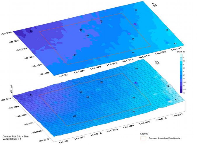
Figure 2: Surface and three dimensional contour plot of the DAFR (Source: McKinnon et al. 2004)
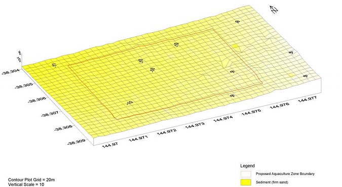
Figure 3: Habitat plot of the DAFR (Source: McKinnon et al. 2004)
Appendix 6: Detailed description of the attributes of the Mount Martha Aquaculture Fisheries Reserve
The physico-chemical and biological features of the Mount Martha Aquaculture Fisheries Reserve (MMAFR) have been assessed and described by the Primary Industries Research Victoria Queenscliff Centre as part of characterisation studies of the area (McKinnon et al. 2004) The following description is a synopsis of this information.
Location
The MMAFR is a 150 ha (approximately 1.9 km by 0.8 km) a greenfield area. The MMAFR is located approximately 700 m offshore from Fossil Beach on the Mornington Peninsula and has the following coordinates:
| Datum GDA94 (Degrees and decimal minutes) | ||
|---|---|---|
| South | East | |
| North West | 38°13.909' | 144°59.917' |
| North East | 38°13.928' | 145°01.059' |
| South West | 38°14.395' | 144°59.903' |
| South East | 38°14.415' | 145°01.046' |
Bathymetry
Water depth at the MMAFR ranges from 11 to 17 m. Inside the eastern boundary of the reserve depths drop away relatively steeply, from approximately 11 m to 13 m, before levelling off and dropping more gradually from 13 m to 17m. The seabed slopes gently away in a north-west direction. A small area of rocky reef is present along the eastern boundary of the MMAFR is due to the presence of an area of rocky reef.
Sediment characteristics
In the characterisation survey a total of 15 randomly allocated sampling sites were analysed. The sediment predominantly consists of very fine to medium-grained sand with a silt component (31–250 µm). Inside the eastern boundary of the MMAFR, where the slope of the bed is slightly steeper, the sediment was coarser. Numerous burrow holes formed by burrowing benthic invertebrates were observed at several locations through out the MMAFR.
Redox measurements were taken from benthic grab samples. The mean redox reading at the sediment surface was 111.1 mV, mean redox reading at 1 cm below the surface was 65.0 mV and mean redox reading at 4 cm was -99.7 mV. These redox readings suggest that the sediments at the MMAFR represented a transitional environment between reducing and oxidising processes, with a slight tendency towards reductive environments.
Benthic fauna
The benthic fauna of the MMAFR consists of many species, dominated by a few taxa. The characterisation study identified a total of 73 taxa, the mean number of individuals per sample was 257. Annelids of the family Lumbrineridae (mean density, 80 individuals per sample), crustaceans of the order Cumacea (mean density, 37 individuals per sample), the cnidarian Edwardsia vivipara (mean density, 17 individuals per sample), molluscs of the family Veneridae (mean density, 12 individuals per sample) and crustaceans of the family Corophiidae (mean density 12 individuals per sample) dominate. The exotic north pacific seastar (Asteria amurensis) was present at various locations within the MMAFR.
Epiflora and epifauna
Tufts of macroalgae from the phyla Phaeophyta, Chlorophyta and Rhodophyta are distributed throughout the MMAFR. The rocky reef was colonised primarily by algae but with some sponges present.
Currents, wind and waves
The MMAFR is subject to daily tidal flushing that generates a considerable mixing and exchange of water. Wind data collected during October 2002 were used with the Port Phillip Bay 400m grid to model currents. Modelled current directions vary from north to north-east on the flood tide, and from south to south-west on the ebb tide. Peak currents generally range from 0.04 to 0.16 m/s.
Wind data from the South Channel Fort Wind Station approximately 20 km south-west of the MMAFR from the year 2000 were collated. The predominant winds in south-eastern Port Phillip Bay are from the south (20%) and the north (18%). The most common wind speed range was 21 - 30 km/h (35%) followed by the 11 - 20 km/h and 31 40 km/h (20%), greater than 40 km/h (16%) and 10 km/h or less (7%).
Wave modelling indicates that the MMAFR has waves greater than 0.5 metres 44% of the time. These waves are primarily produced by winds from the north (10%) and the west (10%). Under a modelled steady 40 knot wind the highest significant wave height at the MMAFR is likely to be 2.1 metres from the north-west.
Water quality
Marine shellfish contamination events are commonly rainfall driven. No notable freshwater discharges occur near the MMAFR and the adjacent urban developments are sewered. The mean annual rainfall for the Mount Martha area is 810 mm.
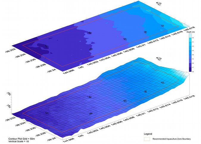
Figure 4: Surface and three dimensional contour plot of MMAFR (Source: McKinnon et al. 2004)
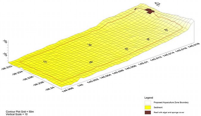
Figure 5: Habitat plot of MMAFR (Source: McKinnon et al. 2004)
Appendix 7: Detailed description of the attributes of the Beaumaris Aquaculture Fisheries Reserve
The physico-chemical and biological features of the Beaumaris Aquaculture Fisheries Reserve (BAFR) have been assessed and described by the Primary Industries Research Victoria Queenscliff Centre, (McKinnon et al. 2004.) The following description is a synopsis of this information.
Location
The BAFR is 25ha (approximately 0.5 km by 0.5 km) in total area, which comprises the former Beaumaris aquaculture harvesting area (3ha) approximately 0.4 km offshore and an extension of 19 ha that is approximately 0.6 km offshore. The BAFR is located approximately 0.6 km (east) offshore from Table Rock Point in Beaumaris Bay and has the following coordinates:
| Datum GDA94 (Degrees and decimal minutes) | ||
|---|---|---|
| South | East | |
| North West | 37°59.693' | 145°2.761' |
| North East | 37°59.699' | 145°3.103' |
| South West | 37°59.963' | 145°2.754' |
| South East | 37°59.969' | 145°3.096' |
Bathymetry
Water depth at the BAFR ranges from 5 to 7 m, the seabed slowly declines in a southerly direction. A small area of rocky reef exists along the southern boundary of the BAFR.
Sediment characteristics
In the characterisation survey a total of 10 randomly allocated sampling sites were analysed. The sediment predominantly consisted of very fine to medium-grained sand with a silt component (31–250 µm). The sediment contained a high degree of broken shell fragments on the surface of the benthos.
Redox measurements were taken from benthic grab samples. The mean redox reading at the sediment surface was 161.4 mV, mean redox reading at 1 cm below the surface was 127.4 mV and mean redox reading at 4 cm was 28.0 mV. These redox readings suggest that the sediments at the BAFR represented a transitional environment between reducing and oxidising processes, with a slight tendency towards reductive environments.
Benthic fauna
The benthic fauna of the BAFR consists of many species, a total of 78 taxa were identified, the mean number of individuals per grab was 266. Annelids of the families Lumbrineridae, Capitellidae and Magelonidae (mean densities, 59, 40 and 33 individuals per sample, respectively), crustaceans of the order Cumacea (mean density, 18 individuals per sample) and echinoders of the class Ophiuroidea (brittle stars) (mean density, 11 individuals per sample) dominate.
Epiflora and epifauna
The Ascidian Pyura stolonifera, sponges, and tufts of macroalgae from the phyla Phaeophyta, Chlorophyta and Rhodophyta, are distributed throughout the BAFR. Patches were present where Pyura stolonifera and sponges appeared to form dense raised colonies. The reef is heavily colonised with sponges.
Currents, wind and waves
The BAFR is subject to daily tidal flushing that generates considerable mixing and exchange of water. Wind data collected during October 2002 from the Fawkner Beacon Wind Station were used with the Port Phillip Bay 400m grid to model currents. Modelled current directions vary from north to east on the flood tide, and from southsouth-west to west on the ebb tide. Peak currents generally range from 0.02 to 0.12 m/s.
Wind data from the Fawkner Beacon Wind Station approximately 14 km north-west of the BAFR from the year 2000 were collated. The predominant wind directions in eastern Port Phillip Bay are from the north (27%) and the south (19%). The most common wind speed range was 21 - 30 km/h (33%) followed by the 11 - 20 km/h (27%), 31 - 40 km/h (17%), 10 km/h or less (14%) and greater than 40 km/h (10%).
Wave modelling using data from the year 2000 indicates that the BAFR has significant wave heights greater than 0.5 metres 29% of the time. These waves are primarily produced by winds from the south (6%), the south-south-west (6%) and the west (6%). Under a modelled steady 40 knot wind the highest significant wave height at the BAFR is likely to be 2.2 metres from the southwest.
Water quality
Marine shellfish contamination events are commonly rainfall driven. The adjacent urban developments are sewered, however there are numerous stormwater drains along the surrounding foreshore. The mean annual rainfall for the Beaumaris area is 689 mm.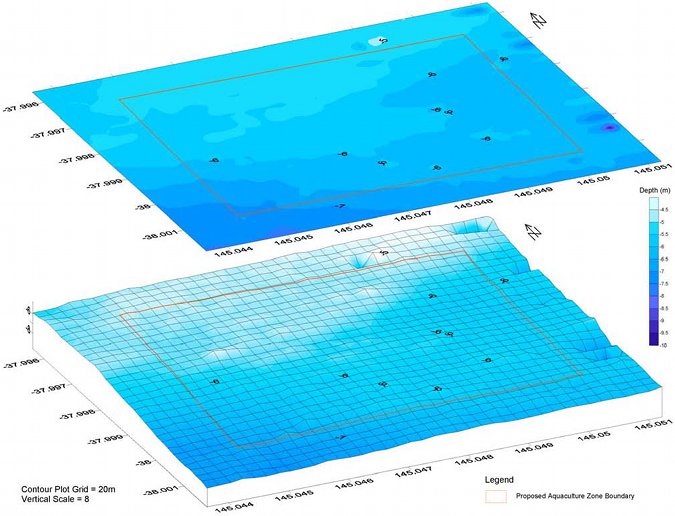
Figure 6: Surface and three dimensional contour plot of BAFR extension and existing area (Source: McKinnon et al. 2004)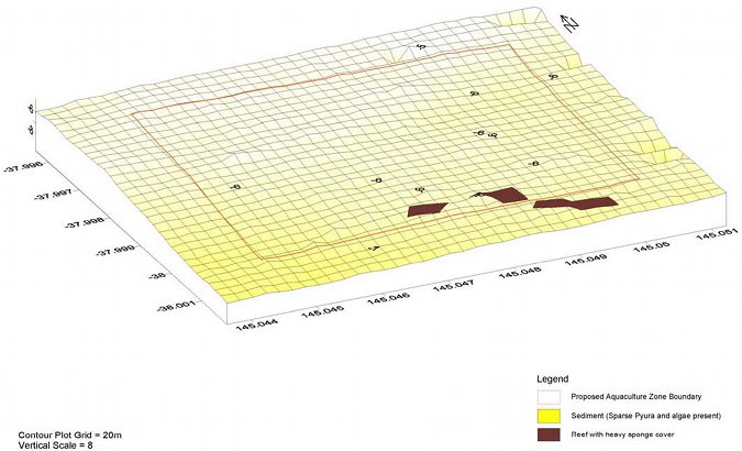
Figure 7: Habitat plot of BAFR extension and existing area (Source: McKinnon et al. 2004)
Appendix 8: Victorian Shellfish Quality Assurance Program (VSQAP) phytoplankton monitoring triggers
| Phytoplankton Abundance Triggers for the VSQAP (cells/L) | |||||
|---|---|---|---|---|---|
| Alga/Algal Group | Toxin | Warning Issued | Tissue Testing | Harvest Suspension Pending Toxin Analysis | Harvest Resumption |
| Bacillariophyceae | |||||
| Pseudo-nitzschia spp (<50% total phytoplankton) | ASP | 100000 | 300000 | 500000 | <10 µg/g domoic acid for 3 successive samples over 14 days; phytoplankton abundance not rising |
| Pseudo-nitzschia spp (>50% total phytoplankton) | ASP | 50000 | 100000 | 200000 | As above |
| Rhizosolenia cf chunii | Bitter Taste | 10000 | N/A | 20000 Level 2 Warning | Harvesting suspended/resumed by growers depending on taste of mussels |
| Dinophyceae | |||||
| Alexandrium catenella | PSP | 100 | Routine or 100 | *500 | <80 µg/g PSP for 3 successive samples over 14 days: phytoplankton abundance not rising |
| Alexandrium minutum | PSP | 100 | Routine or 100 | *500 | As above |
| Alexandrium tamarense | PSP | 100 | Routine or 100 | *500 | As above |
| Alexandrium margalefi | Haemolytic? | 100 | Routine or 100 | 500 | As above |
| Dinophysis acuminta | DSP | 1000 | 1000 | 2000 | <16 µg/100 g PSP for 3 successive samples over 14 days; phytoplankton abundance not rising. |
| Dinophysis caudata | DSP | 1000 | 1000 | 2000 | As above |
| Dinosphysis fortii | DSP? | 1000 | 1000 | 2000 | As above |
| Gymnodinium catenatum | PSP | Presence | *100 | *500 | <80 µg/100 g PSP for 3 successive samples over 14 days; phytoplankton abundance not rising |
| Karenia cf brevis (=Gymnodinium cf breve) | NSP | Presence | *1000 | *5000 | <20 MU/100 g for 3 successive samples over 14 days; phytoplankton abundance not rising |
| Gymnodinium/Karenia spp (NOT catenatum, mikimotoi or brevis) | NSP? | 5000 | 5000 | Not decided | < regulatory limit for biotoxin for 3 successive samples over 14 days; phytoplankton abundance not rising |
| Prorocentrum lima | DSP? | 1000 | 1000 | 2000 | <16 µg/100g DSP for 3 successive samples over 14 days; phytoplankton abundance not rising |
| Prorocentrum minimum | ? | 1000 | 1000 | 2000 | As above |
* Draft National Biotoxin Strategy and New Zealand triggers adopted for now until more information is available for PPB.
| Tissue Biotoxin Regulatory Limits for the VSQAP | ||||
|---|---|---|---|---|
| Toxin Class | Units | Regulatory Limit | Method | Limit of Detection |
| PSP | µg/100g | 80 | Bioassay | 26 |
| ASP (domoic acid) | µg/100g (ppm) | 20 | HPLC | 0.5–1.0 |
| DSP | µg/100g | 16 | HPLC/MS | 0.3 |
| NSP | MUg/100g | 20 | Bioassay | 10 |
| VSQAP Rainfall Triggers – Dromana Aquaculture Fisheries Reserve | |||
|---|---|---|---|
| 24 Hour rainfall (mm) | Minimum closure period | 48 Hour rainfall (mm) | Minimum closure period |
| 16 | 2 days | 16 | 1 day |
µg mircograms
mm millimetres
ASP Amnesic Shellfish Poisoning
MS Mass Spectrometry
DSP Diarrhectic Shellfish Poisoning
MU Mouse Units
g grams
NSP Neurotoxic Shellfish Poisoning
HPLC High Performance Liquid Chromatography
ppm parts per million
PSP Paralytic Shellfish Poisoning
L litres
Appendix 9: Standing Committee members and affiliation
Chair:
Dr David Smith
Primary Industries Research Victoria Queenscliff Centre
Committee members:
Mr Grant Arnold
Department of Primary Industries, Fisheries Victoria
Mr Graeme Creed
Fisheries Co-Management Council
Mr Max Fletcher
VRFish
Mr John Garnham
Department of Primary Industries, Fisheries Victoria
Ms Madeline Glynn
Department of Sustainability and Environment
Mr Robert Hede
Victorian Aquaculture Council
Mr John Hotchin
VRFish
Mr Don Hough
Department of Sustainability and Environment, Parks Flora and Fauna Division
Mr Ross McGowen
Seafood Industry Victoria
Mr John Mosig
Victorian Aquaculture Council
Mr Steve Rodis
Fisheries Co-management Council
Mr Peter Rankin
Fisheries Co-management Council
Executive Officers:
Dr Peter Appleford
Fisheries Victoria
Mr Andrew Clarke
Fisheries Victoria
Mr Geoff Gooley
Primary Industries Research Victoria, Queenscliff Centre
Appendix 10: Potential ecosystem impacts of bivalve mollusc and offshore abalone culture
(Source: modified from Gavine and McKinnon 2002)
Bivalve Culture
| Ecosystem component | Potential threats | Potential consequences | |
|---|---|---|---|
| Source | Impact | ||
| Sediments | Metabolic wastes and pseudo faeces | Accumulation beneath the culture sites | Localised deterioration in ecological quality |
| Dead shells and other detritus | Accumulation beneath the culture sites | Alteration of physical structure of the sediment | |
| Water column | Filter feeding of stock | Uptake of primary and secondary production | Positive impact on coastal eutrophication |
| Depletion of essential nutrients | |||
| Modification of nutrient cycle | |||
| Reduction in dissolved oxygen | |||
| Servicing sites, processing | Input of wastes into water | Water quality impacts | |
| Biological | Seedstock | Collection of wild seed | Impacts on native population |
| Stock | Impacts on seagrass beds | Possible competition for feed | |
| Possible reduction in sunlight | |||
| Culture infrastructure | Obstruction of native fauna | Potential impacts on whales and | |
| Creation of novel habitats for exotics | Proliferation of exotics | ||
| Coastal Resources | Culture infrastructure | Large areas may interfere with the direction and velocity of tidal currents | Changes in sedimentation patterns |
Offshore Cage Abalone Culture
| Ecosystem component | Potential threats | Potential consequences | |
|---|---|---|---|
| Source | Impact | ||
| Sediments | Uneaten feed, pelleted or fresh seaweed. | Accumulation beneath culture sites | Localised deterioration in ecological quality |
| Cage Infrastructure | Scouring of adjacent sediments | Alteration of sediment quality | |
| Water column | Uneaten feed | Possible release of nutrients to water column | Deterioration in water quality |
| Biological | Stock | Escape of hatchery reared stock | Possible impacts on genetic diversity |
| Disease transfer to wild stock, genetic 'pollution' | Possible impacts on wild population | ||
| Cage infrastructure | Creation of novel habitats for exotics | Proliferation of exotics | |
| Coastal Resources | Brood stock collection | Fishing pressure on stocks | Possible impacts on wild population |
Appendix 11: Summary of the recommended responsibilities of Crown lease and aquaculture licence holders
| Crown lease holder | Aquaculture licence holder | |
|---|---|---|
| Authorisation | Crown lease | Aquaculture licence |
| Environmental management | Fund and conduct a baseline survey for the lease site | Fund and conduct an ongoing monitoring program |
| Undertake appropriate remediation actions | ||
| Disease | Report diseases consistent with legislation | |
| Translocation | Comply with the relevant translocation guidelines | |
| Quality assurance programs | Licence holders producing bivalve shellfish for human consumption must participate in the VSQAP and comply with the Australian Shellfish Quality Assurance Program Operations Manual (ASQAAC 2002) | |
| Production reporting | Completion of production reports as required under the Fisheries Act | |
| Artificial feeds | Compliance with the SEPP | |
| Survey and navigation marking | Survey and navigation marking (including maintenance) of the Crown lease site | Maintain all commercial aquaculture equipment within the licence (Crown lease) site |
| Fund and undertake surface infrastructure surveys for compliance purposes as required | Fund and undertake surface infrastructure surveys for compliance purposes as required | |
| Pay a levy for the inspection and maintenance of navigation marking infrastructure relating to the navigation marking of the FAFR | ||
| Infrastructure requirements | Compliant with infrastructure size, shape and colour, and infrastructure attachment recommendations | |
| Request written approval prior to mooring barges, boats and other structures not compliant with the infrastructure recommendations within the FAFR for longer than 5 days | ||
| Stocking rates | Comply with the prescribed input controls | |
| Maintenance and removal of commercial aquaculture equipment | Responsible for removal of improvements from the Crown lease site at the expiry/cancellation of the Crown lease | Responsible for the maintenance of commercial aquaculture equipment as prescribed in the Plan |
| Provision of a bond or bank guarantee | In accordance with the Fisheries Act remove aquaculture equipment at expiry/cancellation of licence | |
| Waste management/processing | Manage waste and processing in accordance with legislation, the relevant food safety/quality assurance programs and industry code of practice | |
| Noise and lighting | Comply with relevant legislation and industry code of practice | |
| Rate of development | Comply with prescribed rate of development for the Crown lease site | Comply with prescribed rate of development for the licence site development |
| Public liability insurance | Hold a public liability trespass insurance policy consistent with the requirements of the Plan | |
| Bonds | Provide a bond or bank guarantee to the prescribed value by an agreed mechanism | |
| Exotic organisms | Report the presence of exotic organisms |
Appendix 12: Transitional arrangements for existing licence holders
The time limits allowed for existing licence holders to become compliant with the Plan are based on three broad categories of risk: human health and safety, environment, and social.
- In regard to management arrangements relating to human health and safety, compliance will be required within three months of the declaration of the Plan.
- In regard to management arrangements relating to environmental risk, compliance will be required within 12 months of the declaration of the Plan.
- In regard to management arrangements relating to social risk, compliance will be required within five years of the declaration of the Plan.
| Transitional arrangement | Risk category | Time permitted for transition |
|---|---|---|
| Navigation marking of licence sites | Human health and safety | Within three months of the declaration of the Plan. |
| Environmental management - ongoing monitoring | Environmental | Within 12 months of the declaration of the Plan. |
| Infrastructure requirements | Environmental | All commercial aquaculture equipment deployed prior to the declaration of the Plan must be compliant with the requirements of the Plan in relation to identification and secure attachment of buoys within 12 months of the declaration of the Plan; and |
| Infrastructure requirements | Social | All commercial aquaculture equipment deployed prior to the declaration of the Plan must be compliant with the visual amenity requirements of the Plan within five years of the declaration of the Plan; and |
| Public liability insurance | Human health and safety | All existing licence holders must provide evidence of a current insurance policy to the Secretary, DPI within three months of the declaration of the Plan. |
Appendix 13: Timetable for the implementation of key actions recommended in the Eastern Port Phillip Bay Aquaculture Fisheries Reserves Management Plan
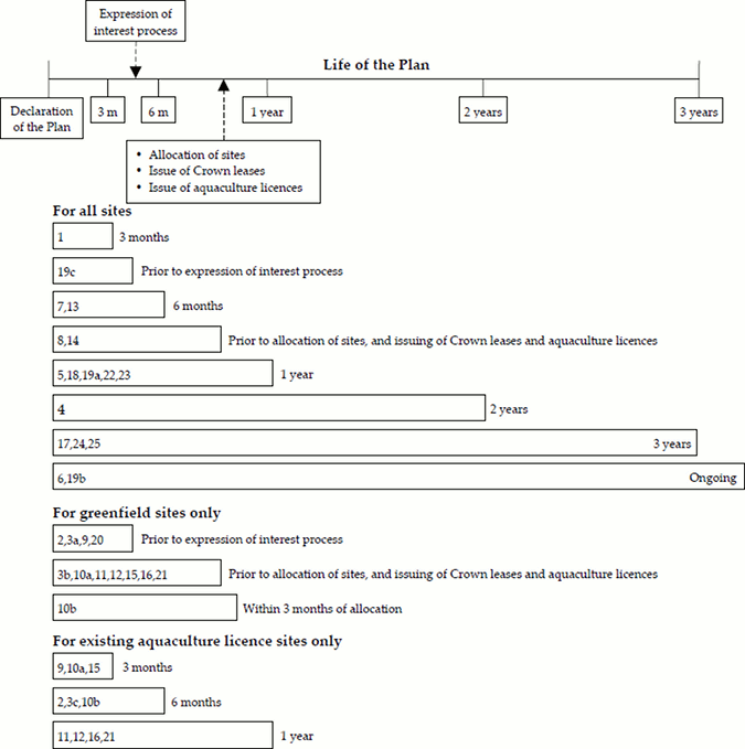
Note: Numbers refer to key actions listed in the 'Key actions to be undertaken in the implementation of the Plan'.
A 'Key action' may have multiple timelines.
For Key action 10, suffixes a and b refer to Timelines a, and b respectively.
For Key action 3 and 19, suffixes a, b and c refer to Timelines a, b and c respectively.
The 'expression of interest' and 'allocation' processes schematically
shown above are not to be taken as indicative of the timing of these events.
Appendix 14: List of recommended fees, costs and levies relating to the implementation of the Eastern Port Phillip Bay Aquaculture Fisheries Reserves Management Plan
Where possible the value of fees, costs and levies is provided below. The value of fees, costs and levies change and consequently the listed amounts are correct at the time of writing only. Costs are reviewed each year and changes are published in the Victoria Government Gazette.
New recommended fees, costs and levies relating to the implementation of the Eastern Port Philip Bay Aquaculture Fisheries Reserves Management Plan.
- A levy to recover costs associated with inspection and maintenance of navigation marking of the Reserves from aquaculture licence holders for each reserve.
- Crown lease holder's and aquaculture licence holder's costs relating to environmental baseline surveys and ongoing monitoring respectively.
- Crown lease holder's costs relating to the provision of a bond or bank guarantee for cost recovery for the removal of abandoned commercial aquaculture equipment.
- Crown lease administration cost.
- Public liability insurance requirements for lease holders.
- Cost of changing infrastructure.
Existing fees, costs and levies relating to aquaculture licences in the Eastern Port Philip Bay Aquaculture Fisheries Reserves.
Fees and levies applicable for the year commencing 1 November 2004 to aquaculture licences in the Eastern Port Philip Bay Aquaculture Fisheries Reserve are illustrated below. Fees and levies are subject to change in accordance with the implementation of cost recovery following a Regulatory Impact Statement or CPI increase.
| Category of Licence | Annual Management FMS Levy1 | Annual Compliance FMS Levy1 | Annual Research FMS Levy1 | Annual FRDC Levy1 | Annual Peak Body Levy2 |
|---|---|---|---|---|---|
| Aquaculture (Crown Land Bivalve Shellfish) Licence | $1091 | $804 | $0 | $154 | $181 |
| Aquaculture (Crown Land Other) Licence | $531 | $571 | $0 | $154 | $181 |
| Aquaculture (Crown Land Abalone) Licence | $509 | $400 | $138 | $154 | $181 |
1 Levied annually per licence.
2 Payable only once per year per licence holder.
The amount of the applicable VSQAP levy for an Aquaculture (Crown Land - Bivalve Shellfish) Licence is calculated in accordance with regulation 617A of the Fisheries Regulations 1998 and varies according to the formula as provided in that regulation. For the 2004/05 licence period the VSQAP levy for the DAFR was $6900.36 per 3 ha.
Lease/licence holders costs relating to the provision of a survey of a lease/licence site.
Lease/licence holder costs relating to the marking of a lease/licence site.